| Citation: | Huayu Lu, Marzieh Mokarram. Machine Learning-Based Integration of Climate and Desert Landform for Analyzing Sand Dune Processes. Journal of Earth Science, 2026, 37(4): 1789-1801. doi: 10.1007/s12583-025-0299-x

|
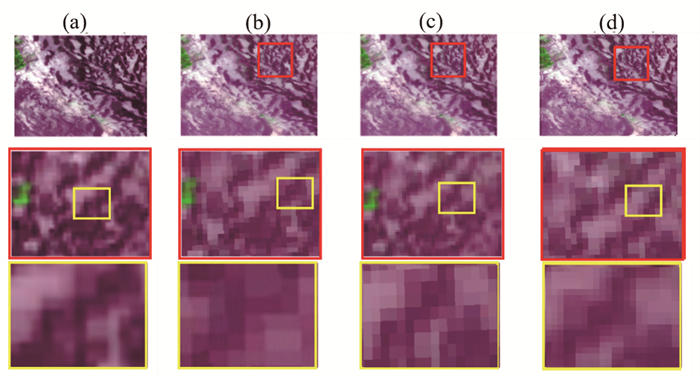
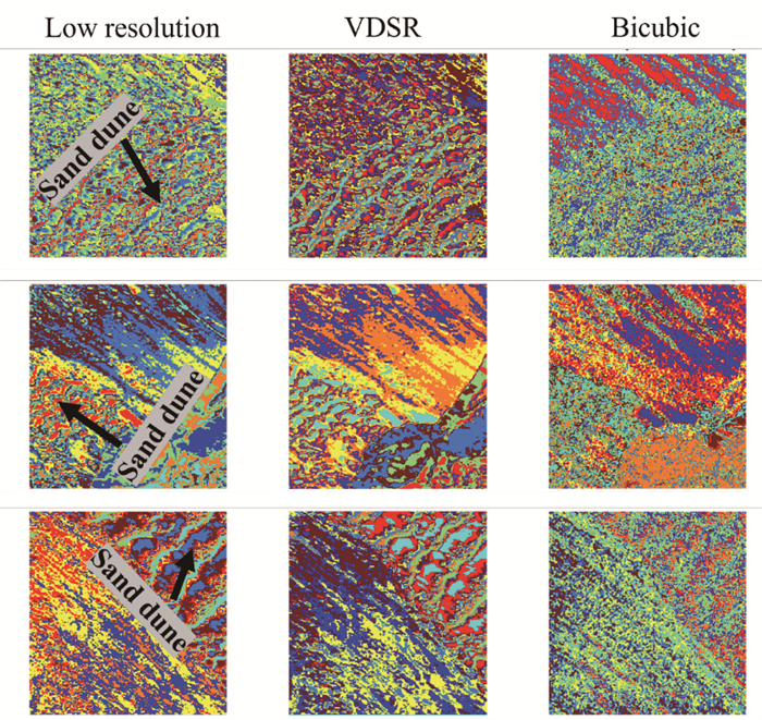
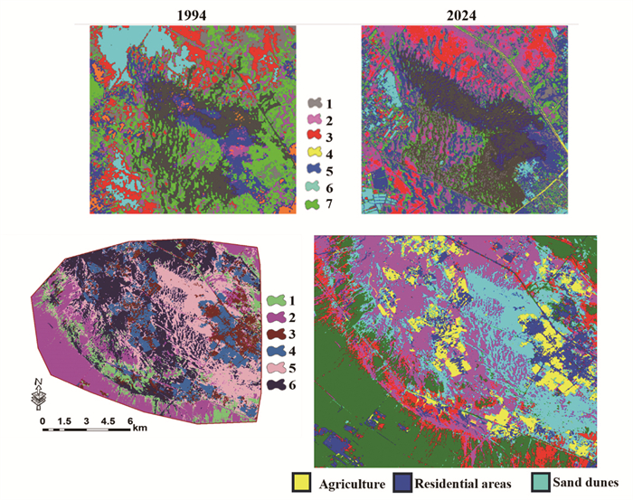
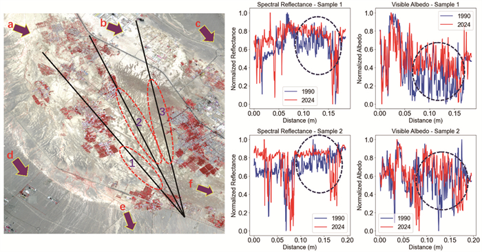
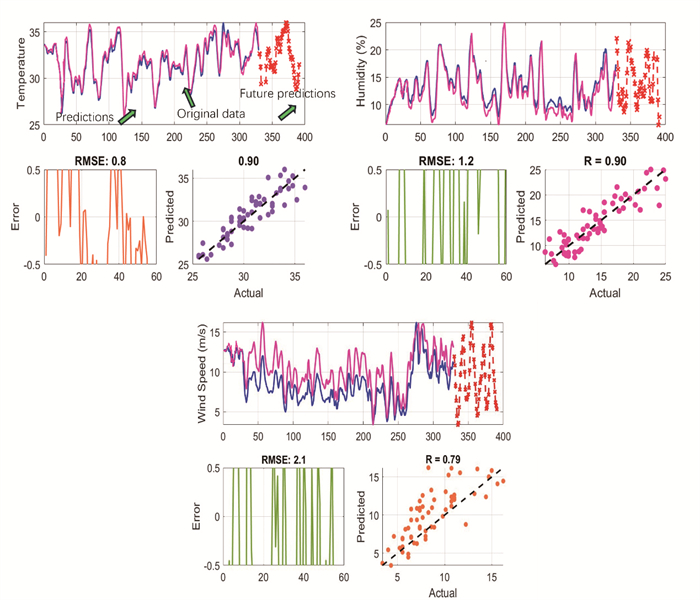
This study aims to identify sand dunes and predict their movement rates using deep neural network-based automatic mapping in the Bafgh Desert, Iran. Additionally, spectrum behavior analysis, including albedo wave and infrared investigations, is conducted to assess dune movement from 1994 to 2024. A machine learning-based neural network is also employed to predict weather parameters and their impact on dune movement. The results indicate that the very deep super resolution (VDSR) deep neural network algorithm significantly enhances satellite image resolution and improves the extraction of morphometric features of sand dunes in desert regions. The U-Net model, with 92% accuracy, effectively classifies sand dunes, which reveals their progression toward residential and agricultural lands and poses significant risks to these areas in the study region. Additionally, spectral reflectance analysis reveals that increases in albedo reflection and infrared wave values indicate the expansion of sand dunes in the study area. Finally, the results of the long short-term memory (LSTM) neural network, with an accuracy of

| Barbhuiya, S., Manekar, A., Ramadas, M., 2024. Performance Evaluation of ML Techniques in Hydrologic Studies: Comparing Streamflow Simulated by SWAT, GR4J, and State-of-the-Art ML-Based Models. Journal of Earth System Science, 133(3): 136. https://doi.org/10.1007/s12040-024-02340-0 |
| Chen, G. X., Li, J., Chen, J. X., et al., 2025. High-Precision Sub-Seafloor Velocity Building Based on Joint Tomography and Deep Learning on OBS Data in the South China Sea. Journal of Earth Science, 36(2): 830–834. https://doi.org/10.1007/s12583-025-0170-0 |
| Chen, S. S., Ren, H. Z., Liu, R. Y., et al., 2021. Mapping Sandy Land Using the New Sand Differential Emissivity Index from Thermal Infrared Emissivity Data. IEEE Transactions on Geoscience and Remote Sensing, 59(7): 5464–5478. https://doi.org/10.1109/TGRS.2020.3022772 |
| Delgado Blasco, J. M., Chini, M., Verstraeten, G., et al., 2020. Sand Dune Dynamics Exploiting a Fully Automatic Method Using Satellite SAR Data. Remote Sensing, 12(23): 3993. https://doi.org/10.3390/rs12233993 |
| Ding, C., Zhang, L., Liao, M. S., et al., 2020. Quantifying the Spatio-Temporal Patterns of Dune Migration near Minqin Oasis in Northwestern China with Time Series of Landsat-8 and Sentinel-2 Observations. Remote Sensing of Environment, 236: 111498. https://doi.org/10.1016/j.rse.2019.111498 |
| Fahmy, A., Domínguez-Bella, S., Martínez-López, J., et al., 2023. Sand Dune Movement and Flooding Risk Analysis for the Pyramids of Meroe, Al Bagrawiya Archaeological Site, Sudan. Heritage Science, 11: 136. https://doi.org/10.1186/s40494-023-00986-5 |
| Fard, K. G., Mokarram, M., 2023. Investigating the Pollution of Irrigated Plants (Rosmarinus Officinalis) with Polluted Water in Different Growth Stages Using Spectrometer and K-Means Method. Environmental Science and Pollution Research, 30(35): 83903–83916. https://doi.org/10.1007/s11356-023-28217-1 |
| Fu, T. L., Li, X. R., 2023. Evaluating the Stability of Artificial Sand-Binding Vegetation by Combining Statistical Methods and a Neural Network Model. Scientific Reports, 13: 6544. https://doi.org/10.1038/s41598-023-33879-5 |
| Goetz, J. N., Brenning, A., Petschko, H., et al., 2015. Evaluating Machine Learning and Statistical Prediction Techniques for Landslide Susceptibility Modeling. Computers & Geosciences, 81: 1–11. https://doi.org/10.1016/j.cageo.2015.04.007 |
| Liu, H. Y., Zhao, P., Ruan, Z. B., et al., 2021. Large Motion Video Super-Resolution with Dual Subnet and Multi-Stage Communicated Upsampling. Proceedings of the AAAI Conference on Artificial Intelligence, 35(3): 2127–2135. https://doi.org/10.1609/aaai.v35i3.16310 |
| Lu, H. Y., Feng, H., Lyu, H. Z., et al., 2023. Formation and Evolution of the Asian Landscape during the Cenozoic. The Innovation Geoscience, 1(2): 100020. https://doi.org/10.59717/j.xinn-geo.2023.100020 |
| Maxwell, A. E., Warner, T. A., Guillén, L. A., 2021. Accuracy Assessment in Convolutional Neural Network-Based Deep Learning Remote Sensing Studies: Part 1: Literature Review. Remote Sensing, 13(13): 2450. https://doi.org/10.3390/rs13132450 |
| Mezaal, M. R., Pradhan, B., Rizeei, H. M., 2018. Improving Landslide Detection from Airborne Laser Scanning Data Using Optimized Dempster-Shafer. Remote Sensing, 10(7): 1029. https://doi.org/10.3390/rs10071029 |
| Mokarram, M., Aghaei, J., Mokarram, M. J., et al., 2023. Geographic Information System-Based Prediction of Solar Power Plant Production Using Deep Neural Networks. IET Renewable Power Generation, 17(10): 2663–2678. https://doi.org/10.1049/rpg2.12781 |
| Mokarram, M. J., Rashiditabar, R., Gitizadeh, M., et al., 2023. Net-Load Forecasting of Renewable Energy Systems Using Multi-Input LSTM Fuzzy and Discrete Wavelet Transform. Energy, 275: 127425. https://doi.org/10.1016/j.energy.2023.127425 |
| Nisa, S. Q., Ismail, A. R., 2022. Dual U-Net with Resnet Encoder for Segmentation of Medical Images. International Journal of Advanced Computer Science and Applications, 13(12): 537–542. https://doi.org/10.14569/ijacsa.2022.0131265 |
| Ofre, D. O., Sawa, B. A., Ummulkhair, H., et al., 2025. Spatio-Spatio-Temporal Analysis of Sand Dunes Migration in the Bulatura Oases Sector of Chad Basin National Park, Nigeria. Journal of Spatial Information Sciences, 2: 206–228. https://doi.org/10.5281/zenodo.14947655 |
| Ooi, Y. K., Ibrahim, H., 2021. Deep Learning Algorithms for Single Image Super-Resolution: A Systematic Review. Electronics, 10(7): 867. https://doi.org/10.3390/electronics10070867 |
| Pradhan, B., 2013. A Comparative Study on the Predictive Ability of the Decision Tree, Support Vector Machine and Neuro-Fuzzy Models in Landslide Susceptibility Mapping Using GIS. Computers & Geosciences, 51: 350–365. https://doi.org/10.1016/j.cageo.2012.08.023 |
| Rehman, K., Fareed, N., Chu, H. J., 2023. NASA ICESat-2: Space-Borne LiDAR for Geological Education and Field Mapping of Aeolian Sand Dune Environments. Remote Sensing, 15(11): 2882. https://doi.org/10.3390/rs15112882 |
| Saldarriaga, L., Tan, Y. M., Sabater, N., et al., 2025. A Pixel-Based Machine Learning Atmospheric Correction for PeruSAT-1 Imagery. Remote Sensing, 17(3): 460. https://doi.org/10.3390/rs17030460 |
| Su, H., Li, Y., Xu, Y. F., et al., 2025. A Review of Deep-Learning-Based Super-Resolution: From Methods to Applications. Pattern Recognition, 157: 110935. https://doi.org/10.1016/j.patcog.2024.110935 |
|
Tsoar, H., Møller, J. T., 2020. The Role of Vegetation in the Formation of Linear Sand Dunes. Aeolian Geomorphology. London: Routledge: 75–96. |
| van der Merwe, B., Pillay, N., Coetzee, S., 2022. An Application of CNN to Classify Barchan Dunes into Asymmetry Classes. Aeolian Research, 56: 100801. https://doi.org/10.1016/j.aeolia.2022.100801 |
|
Vint, D., Di Caterina, G., Soraghan, J. J., et al., 2019. Evaluation of Performance of VDSR Super Resolution on Real and Synthetic Images. In: 2019 Sensor Signal Processing for Defence Conference (SSPD), May 9–10, 2019. Brighton, United Kingdom. IEEE. 1–5. |
| Wang, S. S., Yu, Y., Zhang, X. X., et al., 2021. Weakened Dust Activity over China and Mongolia from 2001 to 2020 Associated with Climate Change and Land-Use Management. Environmental Research Letters, 16(12): 124056. https://doi.org/10.1088/1748-9326/ac3b79 |
|
Wang, Y. Q., Ying, X. Y., Wang, L. G., et al., 2021. Symmetric Parallax Attention for Stereo Image Super-Resolution. In: Proceedings of the 2021 IEEE/CVF Conference on Computer Vision and Pattern Recognition Workshops (CVPRW), June 19–25, 2021. Nashville, TN, USA. IEEE. 766–775. |
| Xu, Z. W., Lu, H. Y., Yi, S. W., et al., 2015a. Climate-Driven Changes to Dune Activity during the Last Glacial Maximum and Deglaciation in the Mu us Dune Field, North-Central China. Earth and Planetary Science Letters, 427: 149–159. https://doi.org/10.1016/j.epsl.2015.07.002 |
| Xu, Z. W., Mason, J. A., Lu, H. Y., 2015b. Vegetated Dune Morphodynamics during Recent Stabilization of the Mu us Dune Field, North-Central China. Geomorphology, 228: 486–503. https://doi.org/10.1016/j.geomorph.2014.10.001 |
| Yadav, A., Jha, C. K., Sharan, A., 2020. Optimizing LSTM for Time Series Prediction in Indian Stock Market. Procedia Computer Science, 167: 2091–2100. https://doi.org/10.1016/j.procs.2020.03.257 |
| Yang, H. J., Wang, Z. Y., Liu, X. Y., et al., 2023. Deep Learning in Medical Image Super Resolution: A Review. Applied Intelligence, 53(18): 20891–20916. https://doi.org/10.1007/s10489-023-04566-9 |
| Yang, Z. L., Qian, G. Q., Dong, Z. B., et al., 2021. Migration of Barchan Dunes and Factors that Influence Migration in the Sanlongsha Dune Field of the Northern Kumtagh Sand Sea, China. Geomorphology, 378: 107615. https://doi.org/10.1016/j.geomorph.2021.107615 |
| Yarahmadi, J., Eslahi, M., Behrawan, H., et al., 2024. Analysis of the Sand Dunes Mobility Based on Climate Elements in East Azerbaijan Province. Environmental Erosion Research, 14(2): 1–18. https://doi.org/10.61186/jeer.14.2.1 |
| Yu, M., Shi, J. C., Xue, C. H., et al., 2024. A Review of Single Image Super-Resolution Reconstruction Based on Deep Learning. Multimedia Tools and Applications, 83(18): 55921–55962. https://doi.org/10.1007/s11042-023-17660-4 |
|
Zheng, Z. H., 2024. Research on Image Super-Resolution Reconstruction Algorithms Based on Deep Learning. In: International Conference on Image, Signal Processing, and Pattern Recognition (ISPP 2024), March 1–3, 2024. Guangzhou, China. SPIE. 129–136. |
| Zhu, Y. B., Dai, Y. H., Han, K. N., et al., 2022. An Efficient Bicubic Interpolation Implementation for Real-Time Image Processing Using Hybrid Computing. Journal of Real-Time Image Processing, 19(6): 1211–1223. https://doi.org/10.1007/s11554-022-01254-8 |

Figures(6) / Tables(1)
Copyright © 2013-2020 Journal of Earth Science 鄂ICP备15021562号-2
Tel: +86-27-67885075 Fax: +86-27-67885075 E-mail: xbb@cug.edu.cn
Address: Editorial Office of Journal, China University of Geosciences, Yujiashan, Wuhan, Hubei 430074, P. R. China
Supported by:
Beijing Renhe Information Technology Co. Ltd
E-mail:
info@rhhz.net



 DownLoad: