| Citation: | Cao Wenbing, Li Wan, Fusheng Hu, Zhaoli Shen, Weide Yan. Characteristics of Water Environment in Regions of Zhaling and Eling Lakes near Waterhead of Yellow River. Journal of Earth Science, 2001, 12(2): 137-141.

|
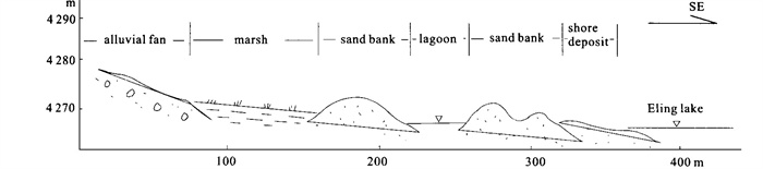
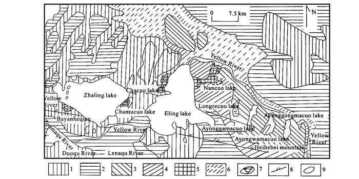
Conditions of the water environment in the region of the Zhaling and Eling lakes, which are located in the frozen earth zone on the Qingzang plateau, are unique. The equilibrium of the water quantity of the two lakes is maladjustment under the condition of a dry and cold climate in which evaporation is greater than precipitation. The Zhaling and Eling lakes have been atrophying, leaving three lake terraces and star studded lagoons around the two lakes since Holocene. When these lagoons were separated from the original lakes, they became cut lake basins, and were transformed from fresh water lakes into salt water lakes, salt lakes or salt playas owing to strong evaporation. This kind of evolutionary process will continue in the future.

| Li M, 1995. Impact of Human Activities on the Environmental Changes of Qinghai Region in Recent Period in Qinghai-Xizang Plateau in a Study of the Formation and Evolution Environmental Changes and Ecological System of the Qinghai-Xizang Plateau. Beijing: Scintific Press |
| Yu S, Wen Q, 1995. Geochemical Evolution and Environment Changes since Late Cenozoic in Qinghai-Xizang Plateau in a Study of the Formation and Evolution Environmental Changes and Ecological System of the Qinghai-Xizang Plateau. Beijing Scintific Press |
| Zhao X, 1995. Studies on the Characteristics of Temperature and Precipitation Changes in the Qinghai-Xizang Plateau in Qinghai-Xizang Plateau in a Study of the Formation and Evolution Environmental Changes and Ecological System of the Qinghai-Xizang Plateau. Scintific Press |

Figures(3) / Tables(3)
Copyright © 2013-2020 Journal of Earth Science 鄂ICP备15021562号-2
Tel: +86-27-67885075 Fax: +86-27-67885075 E-mail: xbb@cug.edu.cn
Address: Editorial Office of Journal, China University of Geosciences, Yujiashan, Wuhan, Hubei 430074, P. R. China
Supported by:
Beijing Renhe Information Technology Co. Ltd
E-mail:
info@rhhz.net


 DownLoad: