| Citation: | Zukuan Wei, Jaehong Kim, Haeyoung Bae. Fast Web-Based Data Transmission. Journal of Earth Science, 2001, 12(2): 165-176.

|
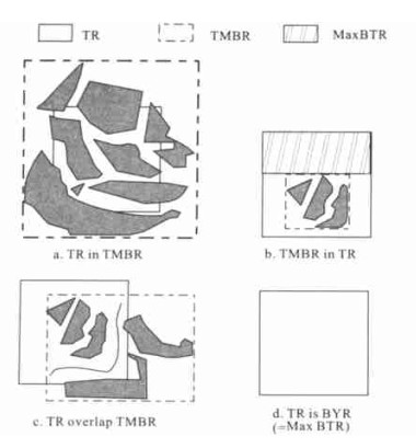
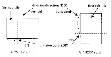
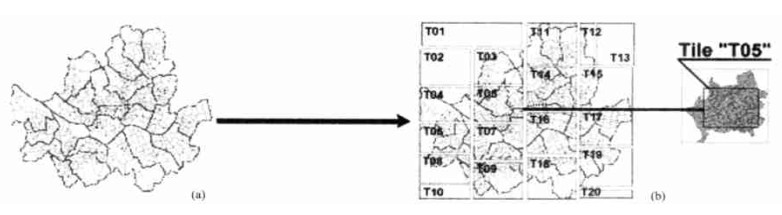
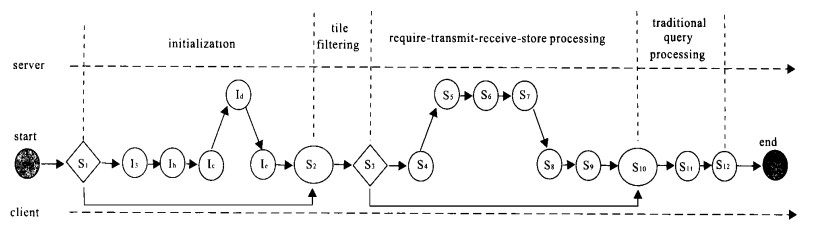
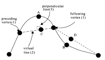
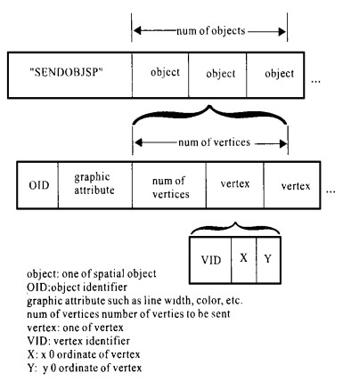
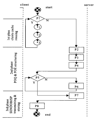
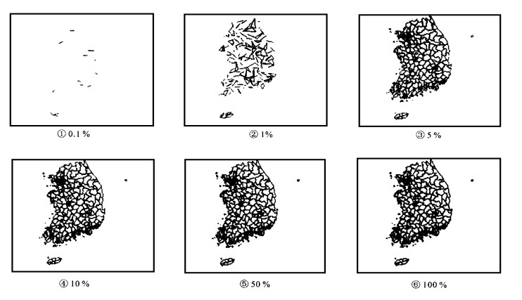
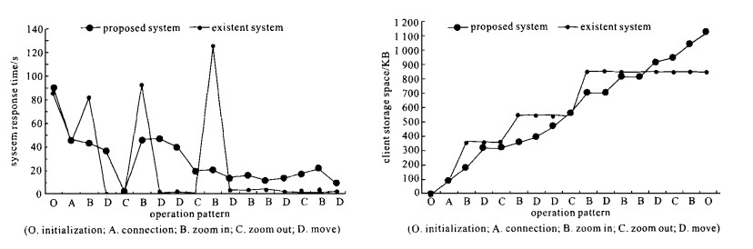
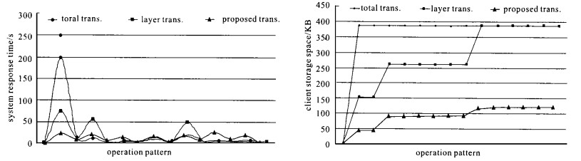
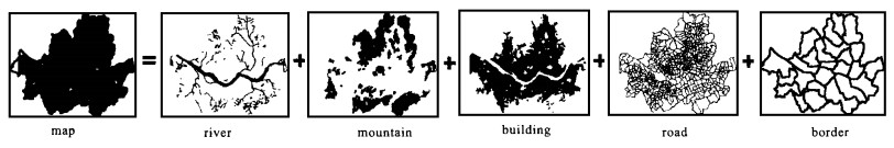
Since web-based GIS processes large-size spatial geographic information on internet, we should try to improve the efficiency of spatial data query processing and transmission.This paper presents two efficient methods for this purpose: division-transmission and progressive-transmission methods.In division-transmission method, a map can be divided into several parts, called "tiles", and only tiles can be transmitted at the request of a client.In progressive-transmission method, a map can be split into several phase views based on the significance of vertices, and a server produces a target object and then transmits it progressively when this spatial object is requested from a client.In order to achieve these methods, the algorithms, "tile division", "priority-order estimation" and the strategies for data transmission are proposed in this paper, respectively.Compared with such traditional methods as "map total transmission" and "layer transmission", the web-based GIS data transmission, proposed in this paper, is advantageous in the increase of the data transmission efficiency by a great margin.

| Aronoff S, 1991. Geographic Information Systems. WDL Publications |
| Autodesk, 1998. Mapguide2.5Refrence. Autodesk Inc |
| Beckmann N, Kriegel H P, Schneider R, et al, 1990. T he R*-T ree: An Efficient and Robust Access Method for Points and Rectangles. Proc of AC M SIGMOD Int Conf, Atlantic City, NJ |
| Berstein A, 1995. Wondering What T ransparent or Interlaced GIFs are?", http://www.cis.columbia.edu/homepages/gonzalu/transparent-gifs/transparent.html |
| Brinkhoff T, Kriegel H P, Schneider R, 1993. Comparison of Approximations of Complex Objects Used for Approximation-Based Query Processing in Spatial Database Systems. 9th Int Conf on Data Engineering, Vienna, Austria |
| Brinkhoff T, Horn H, Kriegel H P, et al, 1993. A Storage and AccessArchitecture for Efficient Query Processing in Spatial Database Systems. 3rd Symp on Large Spatial Databases, Singapore |
| Burrough P A, 1986. Principles of Geographic Information Systems for Land Resources Assesment. Oxford: Oxford Univ Press |
| Luis M C, Web-Based GIS: A brief History. http://blaze.trentu.ca/-ermlc/web-gis.html |
| Choo Y, Lee C, 1997. Integrated Distributed Geographical Information Systems (IDGIS). 1997ESRI International User Conference |
| Cho Y S, Kim H Y, Kim J H, et al., 1998. T he Design and Implementation of Componentized Web-Enabled GIS. ICIMU 98 |
| Cho Y S, Kim H Y, Bae H Y, 1998. GIS Solutions for Supported WWW Environments. Journal of Korea Information Science Processing, 16(3): 168-173 |
| CITRIX, 1997. WinFrame WorkGroups1.7. Citrix Systems Inc |
| ESRI, MapObjects internet Map Server(IMS). http://www.esri.com/software/mapobjects/ims/index.html |
| ESRI, 1997. MapObject 1.0Refrence. ESRI Inc |
| Guenther A. Buchmann, 1990. Research Issues in Spatial Databases. Acm Sigmod Record, 19(4): 61-68 |
| Guting R H, 1989. Gral: An Extensible Relational Database System for Geographic Applications. 15th Int Conf On Very Large Data Bases, Amsterdam, Netherland |
| Guting R H, 1994. An Introduction to Spatial Database Systems. VLDB Journal, 3(4): 357-399 |
| Gutman A, 1984. R-T rees: A Dynamic Index Structure for Spatial Searching. Proc of Acm Sigmod, 13: 47-57 |
| James T Hathaway, Demographic Data Viewer 3.0 T utorial. CIESIN, Columbia University |
| Heng C L, 1997. Image Compression: JPEG with Emphasis on Baseline Lossy JPEG. Progressive & Motion-JPEG |
| Hoppe H, 1996. Progressive Meshes. SIGGRAPH96Proc, Aug |
| Intergraph, 1998. GeoMedia Web Map1.0Refrence. Intergraph Corporation |
| Internet GIS, 1997. ActiveMaps2.0 Manual. internetGIS |
| Kim Y T, Kim J H, Hae H Y, 1996. Implementation of Spatial Query Processor in GEOBase. Proceeding of Korea Information Science Society, 3(2): 213-217 |
| Kriegel H P, Horn H, Schiwietz M, 1991. T he Performance of Object Decomposition Techniques for Spatial Query Processing. 2nd Symp on Large Spatial Databases, Zurich, Switzerland |
| Kriegel H P, Heep P, Heep S, et al, 1991. An Access Method Based Query Processor for Spatial Database Systems. Int Workshop on Database Management Systems for Geographic Applications, Capri, Italy |
| Liedekerke M V, Jones A, Graziani G, 1997. T he European T racer Experiment Information System: Where GIS and WWW Meet. 1995 ESRI User Conference |
| Matuschak B J, 1996. Commentary: GIS is Being Redefined by Current Computing T rends. T he Electronics Atlas Newsletter, Vol. 7, No. 9, http://www.electronic.atlas.com/ |
| Peng Z R, 1997. An Assessment of the Development of internet GIS. Proceedings of the ESRI User Conference |
| Ryu H S, Kim K B, Cho Y S, et al, 1997. Design and Implementation of Geographic Information System in WWW Environment: GEO/ WEB. Proceeding of Korea Information Science Society, 24(1): 94-98 |
| Samet H, 1990. T he Design and Analysis of Spatial Data Structures. Addison Wesley |
| Seeger B, Kriegel H P, 1988. Techniques for Design and Implementation of Efficient Spatial Access Methods. 14th Int Conf on Very Large Databases, Los Angeles, CA |
| Stephen L D, T homas B E, Approaches for Delivering Raster and Vector Data over the Internet. http://www.gis.umn.edu/fornet/info/papers/seven/index.html |
| Torrijos S, HIGIS (Hurricane internet Geographic Information System). http://131.94.54.47/Higis2/About.html |
| US Census Bureau, TIGER Map Service. http://www.census.gov/geo/www/tiger/overview.html |
| Volker G, 1998, Multidimensional Access Methods. Acm Computing Surveys, 30(2): 73-79 |
| Wallace G K, 1991. The JPEG Still Picture Compression Standard", Communications of the ACM, 34 |
| Wang F, 1999. Spatial Data Model for Feature-Based GIS", Proceedings of the Workshop on Computer Science and Information Technologies CSIT'99, Russia |
| White R L, Percival J W, 1994. Compression and Progressive T ransmission of Astronomical Images. SPIE Technical Conference2199 |
| Vicinity, MapBlast. http://www.mapblast.com/ |
Figures(16) / Tables(1)
Copyright © 2013-2020 Journal of Earth Science 鄂ICP备15021562号-2
Tel: +86-27-67885075 Fax: +86-27-67885075 E-mail: xbb@cug.edu.cn
Address: Editorial Office of Journal, China University of Geosciences, Yujiashan, Wuhan, Hubei 430074, P. R. China
Supported by:
Beijing Renhe Information Technology Co. Ltd
E-mail:
info@rhhz.net


 DownLoad: