
Citation: | Yongqing Chen, Hongguang Liu. Delineation of Potential Mineral Resources Region Based on Geo-anomaly Unit. Journal of Earth Science, 2000, 11(2): 158-163. |
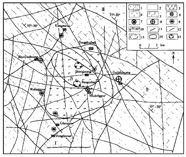
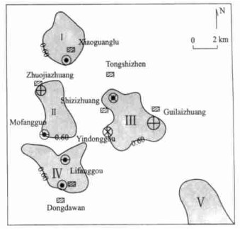
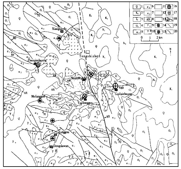
The geological anomaly unit method (GAUM) is a new way to delineate and evaluate ore finding targets in line with the "geological anomaly ore finding theory". Comprehensive ore finding information from geological, geochemical and geophysical data is used for quantitative measurement of the "ore forming geological anomaly unit" in this paper. The main procedures are shown as follows: (1) The geo anomalous events associated with gold mineralization are analyzed in Tongshi gold field; (2) The zonation in the concentrated heavy minerals and the stream sediment elements of ore forming geo anomaly are studied in detail; (3) The deep geological structural framework is deduced by means of the synthetic geological interpretation of gravity and magnetic information; (4) The ore controlling geo anomalies and ore anomalies are chosen as the variables of the favorable ore forming indexes that can be used for the quantitative delineation and evaluation of the potential ore forming regions.
It is well known that the geophysical and geochemical anomalies are very important for the location of mineral deposits. However, the concept of geo-anomaly and its significance in mineral exploration had hardly been expounded until 1990s. In fact, the geo-anomaly that has wider implications than the geophysical and geochemical anomalies do, can be widely applied to the assessment of mineral resources and the explanation of some crucial geological phenomena. A geo-anomaly is defined as a geological body or/and a combination of geological bodies whose composition, texture-structure and genetic order are quite different from those of their surroundings (Zhao and Chi, 1991). This definition covers the natural property that mineral deposits are regarded as natural accumulation in the crust. Therefore, a thorough investigation of geo-anomaly constitutes the basis of the ore-forming prognosis. Mineral deposits are products of geological anomalous events. In addition, the geophysical and geochemical anomalies are the representation of the geo-anomaly both in physical and chemical properties. Therefore, the geo-anomaly may also be regarded as a statistically significant deviation of particular geological features of homogeneous geological bodies in a given sector during a given evolutionary stage of the structure as a whole (Gorelov, 1982), which lays the foundation for the application of the statistical method to the research into the geo-anomaly.
Mineral resources bodies refer to the crust areas where some ore-forming elements are concentrated by geological mechanism during a certain geological period. Part of the mineral resources bodies that can be commercially utilized on the present economic and technical conditions is called ore bodies, and the ore-forming geo-anomalies based on the relationship between the geo-anomalies and the formation and distribution of mineral resource bodies, can be primarily classified as two categories: (a) ore-controlling geo-anomalies, such as ore-controlling faults, intrusive bodies and strata, and (b) geological ore anomalies such as altered mineralization haloes. An ore-forming geo-anomaly unit is a prospective minerlized region delineated by integrated ore-forming information with the help of computer techniques (Chen and Zhao, 1997). Main procedures of the method for the quantitative delineation of the potential mineral resources regions are below. (a) determination of ore-forming geoanomaly events; (b) extraction of ore-forming information based on the synthetic analyses of the ore-forming geo-anomaly events; (c) establishment of the conceptual model for thedelineation of the ore-forming geo-anomaly units; (d) selection and target variables and quantification of the variables; (e) establishment of the favorable ore-forming index model for the delineation and evaluation of the variables; (f) quantitative delineation and assessment of potential mineral resources regions. An example from Tongshi gold field, the western Shandong uplift area, Eastern China, is given to illustrate the method and its effect on the location of ore-bodies.
The Tongshi gold field is located in the hidden basement area in the western margin of the Pingyi Mesozoic volcanic sedimentary basin in the western Shandong uplift terrain, Eastern China. The multi-phase intrusive activities of the magma in the early Yanshan epoch that resulted in the formation of the Tongshi sub-volcanic alkalic intrusive complex are main geo-anomalous events leading to the formation of the mineral resources series in the Tongshi gold field. The Tongshi sub-volcanic complex constitutes the primary ore-controlling geological anomaly in the gold field, and also the geological background for the formation of gold resources series. The complex composed of hypabyssal suites of diorite-porphyrite and syenite-porphyry enriches in K2O (4.06%-10.12%) and Au (5.40×10⁻¹²-12.46×10⁻¹²). The complex indicates negative gravity fields, where the diorite-porphyrite shows obvious positive magnetic fields, but the syenite-porphyry shows the negative magnetic fields in the vertical second derivative of the gravity and magnetic anomalies that extended upward to 3 km. Two w(40Ar)/w(39Ar) analyses of amphiboles from the diorite-porphyrite and the syenite-porphyry suites have recorded ages of 189 Ma and 188 Ma, respectively (Yu, 1996). It is inferred from the isotopic ages and the intersections of the intrusive bodies that the diorite-porphyrite suite solidified earlier than the syenite-porphyry suite did. The exposed rocks in the ore field are mainly composed of Archean metamorphic rocks, Cambrian and Ordovician carbonate rocks. The composition of the breccia is complex (metamorphic rocks, carbonate rocks, diorite-porphyrite and syenite-porphyry) and zoned (Chen and Zhao, 1998). Numerous gold deposits (gold occurrences) scattering around the Tongshi complex may be classified as four categories: (a) Porphyry gold occurrence; (b) Skarn gold occurrence; (c) Cryptobreccia gold deposit; (d) Carlin gold deposit, constituting gold mineral resource series (Fig. 1).
Mineral assemblages and ore components from various types of gold deposits (gold occurrences) and their geological features are listed in Table 1 and Table 2, respectively. The following results can be obtained from the tables: (a) The porphyry gold occurrence, hosted in syenite-porphyry, and characterized by a metal mineral association of native gold as well as pyrite, is rich in Au, Ag, Sb, Pb, K2O, As, and poor in Cu, F and Na2O; (b) The skarn gold deposit, hosted in the skarn rocks within contact zone between diorite-porphyrite and carbonate rocks, and characterized by a metal mineral association of magnetite, copperpyrite as well as pyrite, is rich in Au, W, Mo, As, Ag, Sb, Cu, F, and poor in Pb, Na and SiO2; (c) The cryptobreccia gold deposit, hosted in cryptobreccia controlled by faults, and characterized by a metal mineral association of native gold, electrum as well as calaverite, is rich in Au, Ag, Sb, W, As, F, K2O; (d) The Carlin gold deposit, hosted in silicated carbonate rocks, and characterized by a metal mineral association of micro-fine native gold as well as micro-fine pyrite, is rich in Au, Ag, F, Sb, As, Pb and Zn. In particular, the cryptobreccia gold deposits such as the large Guilaizhuang gold deposit (Chen, 1998), and the Carlin gold deposits such as the Mofanggou, Lifanggou and Dongdawan gold deposits (Fig. 1) are the most prospective in economical value.
![]() |
![]() |
The 1∶50 000-scale data on the concentrated heavy minerals and stream sediments of Au, Ag, W, Bi, Mo, Cu, Pb, Zn, As and Sb within the Tongshi gold field are collected from Shandong Bureau of Geology and Mineral Resources to compile the corresponding anomalous zoning map. The compiling sequences are shown as follows: (a) The gold anomalous catchment basins are determined based on the anomalous map of gold stream sediments on the corresponding scale. (b) Different symbols are used to show the anomalous associations of both concentrated heavy minerals (a high temperature association of native gold: wolframite (scheelite), bismuthinite and molybdenite; an intermediate temperature association of native gold: chalcocite, sphalerite and cerussite, and the low temperature association of native gold: stibbnite, realgar and orpiment) and stream sediments (a high temperature association of Au: W, Bi, and Mo; an intermediate temperature association of Au: Cu, Pb and Zn, and the low temperature association of Au: Ag, As and Sb), respectively. (c) The zero value line of the vertical second-order derivative of gravitational field extending upward to 3 km on the same scale is regarded as the hidden boundary between the Tongshi complex and its surrounding rocks (Fig. 2). (d) The gold deposits (occurrences) are turned to draw on the same map according to the corresponding coordinates respectively to form the anomalous zoning map of concentrated heavy minerals and anomalous elements from the stream sediments (Fig. 2).
Obvious anomalous zonation of both the concentrated heavy minerals and the stream sediments illustrated in Fig. 2 has the following features. (a) There are three zones: inner zone (Ⅰ), middle zone (Ⅱ) and outer zone (Ⅲ) around the Tongshi complex. The inner zone is distributed within the complex; the middle zone in the contact zone between the complex and its surrounding rocks, and the outer zone within the range between 1 km to 6 km from the complex. All zones converge on the southwestern side of the gold field, and diverge on the northeast side of the gold field, showing that the complex may plunge downwards to the northeast side of the gold field. (b) Anomalies of concentrated heavy minerals, mainly scattered in the inner and middle zones, consist of high-low and intermediate-low temperature mineral associations and intermediate-low, and low temperature mineral associations in the outer zone. (c) Anomalies of stream sediments are scattered in all zones. In addition, the distributions of the anomalous associations are similar to those of the concentrated heavy minerals in the inner and middle zones. The single gold anomaly is only scattered in the outer zone. (d) Porphyry gold occurrences and skarn gold deposits, located in the inner zone, have the anomalous associations of intermediate-high temperature of both concentrated heavy minerals and stream sediments. The cryptobreccia gold deposits and Carlin gold deposits located in the middle and outer zones have the anomalous associations of intermediate-low and low temperature of both the concentrated heavy minerals and the stream sediments. The large Guilaizhuang gold deposit, situated in the middle zone, has an anomalous association of low-temperature concentrated heavy mineral and stream sediments.
The features mentioned above suggesting the multi-epoch and multi-stage gold ore-forming activities serve the selection of target variables and the assessment of different kinds of potential gold mineral resources regions.
The 1∶50 000-scale data on the gravity and magnetic survey within the studied area are collected from the Shandong Bureau of Geology and Mineral Resources. The deep structure map of ore-forming geo-anomaly is compiled through the comprehensively geological interpretation of these data to study ore-controlling mechanism of deep geo-anomaly (Fig. 3). The gold ore field is divided into four geological units according to the deep structure map. (Ⅰ) Hidden basement refers to the double-structure region with the lower structure structure being Precambrian crystalline basement and the lower structure Paleozoic carbonate rocks. The Precambrian crystalline basement in the western Shandong uplift terrain characterized by the granite-green terrain is an important gold-bearing rock series. The carbonate rocks are favorable for the formation of the hydrothermal ore deposits. (Ⅱ) Paleozoic carbonate rock basin is an important wallrock hosted the Carlin gold deposits. The boundary between this basin and its neighboring units are inferred by the geological interpretation of the aero-magnetic data, because obvious differences exist among carbonate rocks and other rocks in the magnetic field. (Ⅲ) Mesozoic fault volcanic rock basin. The boundary between this basin and its neighboring units is inferred by the geological interpretation of the gravity data, because obvious differences exist between this basin and other units in the gravity field. (Ⅳ) Tongshi complex. This unit is thought of as a geo-anomaly unit, because it controls the formation and distribution of various gold deposits within the studied area. The boundary between the complex and its neighboring units is approximately determined by the zero line of the vertical second-order derivative of the gravity field extending upward to 3 km. The major distribution pattern of the diorite-porphyrite is approximately determined by the zero line of the vertical second-order derivative of the magnetic field extending upward to 3 km.Figure 3 shows that the magma constituting the complex may intrude along the interface between the hidden basement and the carbonate basin, that the deep gravity and magnetic fractures are almost characteristic of the northwest and northeast strike, that the shallowest gravity and magnetic fractures are characteristic of east-west and south-north strike, and that the density of the fractures within the hidden basement is higher than that of the fractures within the carbonate rock basin. However, no fracture is scattered within the volcanic rock basin.
In the Early Yanshanian epoch, the intermediate magma intruded upward along the interference between the hidden crystalline basement and the carbonate rock basin, resulting in the diorite-porphyrite mainly distributed in the region delineated by the zero line of vertical second-order derivative of magnetic field extending upward to 3 km. Skarn gold deposits are scattered around the intrusive rock, like the Shizizhuang gold deposit. Then, the Precambrian crystalline basement enriched in Au was partly melted by the thermodynamic mechanism related to the intrusion of the intermediate magma resulting in the intermediate magma enriched in K2O, which then intruded upward along the interference between the hidden crystalline basement and the diorite-porphyrite resulting in the formation of the syenite-porphyry. At the end of the activity of the intermediate magma enriched in K2O, porphyry gold deposits occurred within the syenite-porphyry, and the cryptobreccia gold deposits as well as Carlin gold deposits were present around it, respectively (Fig. 3). It is the diorite-porphyrite and the syenite-porphyry that constitute the Tongshi complex. The geo-anomaly ore-forming concept model of the gold deposits is summarized as follows according to the analyses mentioned above: (a) Archean metamorphic rocks; (b) Paleozoic carbonate rocks; (c) the Tongshi complex; (d) faults; (e) anomalous association of both concentrated heavy minerals and stream sediments.
The following variables are selected according to the geo-anomaly model: diorite-porphyrite x1; syenite-porphyry x2; metamorphic rocks x3; carbonate rocks x4; east-west-striking faults x5; south-north-striking faults x6; northeastern-striking faults x7; northwestern-striking faults x8; intersections of faults x9; high temperature association of concentrated heavy minerals x10; intermediate temperature association of concentrated heavy minerals x11; low temperature association of concentrated heavy minerals x12; high temperature anomalous association of elements from stream sediments x13; intermediate temperature anomalous association of elements from stream sediments x14; low temperature anomalous association of elements from stream sediments x15; gold concentration zonation (I) x16; gold concentration zonation (Ⅱ) x17; gold concentration zonation (Ⅲ) x18. The 0.5 km×0.5 km is taken as a sample cell for assigning the target variables with values. There are 340 sample cells within the studied area. The variables describing samples are assigned with the quantitative values according to certain rules to make each feature of the samples correspond to a definite value, so that the variations of the variables can be expressed through the changes of their number values. The variables are assigned 1 or 0 according to what can be observed or what are known to be absent for each sample cell. The value of 1 may mean favorable, but the value of 0 mean unfavorable, forming the m (340)×n (18) data matrix for the calculation of the favorable ore-forming index. According to the formula of characteristic analysis (McCammon et al., 1983), the favorable ore-forming index F of a given sample cell is established
F=0.040 2x1+0.040 8x2+0.142 7x3+0.041 8x4+0.045 3x5+0.081 9x6+0.070 2x7+0.120 0x8+0.078 7x9+0.009 5x10+0.0166 x11+0.033 3x12+0.015 2x13+0.027 1x14+0.044 2x15+0.089 8x16+0.066 3x17+0.036 4x18
0.60 is chosen as the threshold for the delineation of the targets by varying the gradient of the favorable ore-forming index. In this way, 5 ore-forming geo-anomaly units are delineated in the studied area (Fig. 4). Because the 18 variables constituting the function of ore-forming favorability belong to the variables of both the ore-controlling geo-anomaly and ore anomaly, 5 ore-forming geo-anomaly units delineated by F values are regarded as potential gold mineral resources regions, in which unit Ⅲ is the target where the large Guilaizhuang gold deposit is found.
Application of the geo-anomaly unit method to the delineation of the potential gold mineral resources regions, a key step of the systematic ore-finding strategy of "5P" (Zhao and Chen, 1998) based on the geo-anomaly ore-forming principle, attempts to combine the ore-controlling anomaly with the ore anomaly, the obvious geo-anomaly with the hidden one, the deep ore-finding information with the shallow one, and the direct ore-finding information with the indirect one, and also to concentrate various ore-forming information through a series of information processing procedures such as the extraction, connection, transform and synthesis of multiple-discipline ore-forming information. Comprehensive information of both ore-controlling geo-anomaly and ore anomaly is selected to be target variables for the prediction of new mineral deposits and eventually for the quantitative delineation of the potential mineral resources regions. In this way, the mineral exploration risk and uncertainty can be reduced and the accuracy and efficiency of the mineral exploration can be improved.
Chen Y Q, Zhao P D, 1997. The Delineated Method of Geological Anomaly Units and Its Application in the Statistical Prediction of Gold Deposit of Large Scale. In: Zhao P, ed. Proc 30th Int Geol Congr. VSP, Utrecht, The Netherlands. 23-32 |
Chen Y Q, Zhao P D, 1998. Zonation in Primary Halos and Geochemical Prospecting Pattern for the Guilaizhuang Gold Deposit, Eastern China. Nonrenewable Resources, 7(1): 37-44 doi: 10.1007/BF02782507 |
Gorelov D A, 1982. Quantitative Characteristics of Geological Anomalies in Assessing Ore Capacity. Internal Geology Rew, (4): 457-465 |
McCammon R B, Botbal J M, Larsen R S, 1983. Characteristic Analysis—1981: Final Program and a Possible Discovery. Math Geology, 15(1): 59-84 doi: 10.1007/BF01030076 |
Zhao P D, Chi S D, 1991. A Preliminary View on Geological Anomaly. Earth Sciences—J China Univ Geosci, 16(3): 241-248 |
Zhao P D, Chen Y Q, 1998. The Main Way of Geo-anomaly Location of Ore Body. Earth Sciences—J China Univ Geosci, 23(2): 111-114 |
Yu X F, 1996. A New Type of Gold Deposit in Shandong Province—The Guilaizhuang Gold Deposit. In: Shandong Bureau of Geology and Mineral Resources, ed. Proc of Researches on the Geology and Mineral Resources in Shandong Province. Jinan: Shandong Science and Technology Publishing House. 129-140 |
![]() |
![]() |