Advanced Search

Indexed by SCI、CA、РЖ、PA、CSA、ZR、etc .

2000 Vol. 11, No. 2

Display Method:
 
Important Issues of Sustainable Development: Research of Nontraditional Mineral Resources
Pengda Zhao, Jianping Chen
2000, 11(2): 95-99.
Abstract:

Nontraditional resources refer to that potential mineral resources are unconsidered and unutilized under actual condition of technique, economic and environment, or some mineral resources are too difficult to find because of geological complexity. There are some signified problems about discovery and exploration of nontraditional mineral resources to be discussed in this paper. It is a very significant project next century, and makes development bases for offspring, which its research and practice the theory of nontraditional mineral resources need interactive combination.

Geology, Mineralogy and Geochemistry of Carbonate Replacement-Type Lead-Zinc-Silver Deposits in Janggun Mine, Republic of Korea
Hyun Lee, Chan Hee Lee, Bong-Cheal Yoo, Jong Chang Lee
2000, 11(2): 100-102.
Abstract:

The present study focuses on geology and geochemical environment of the Pb Zn Ag ore deposition. Mineralization, mineralization age, mineral assemblage, mineral chemistry, host rock alteration, fluid inclusion and stable isotope geochemistry are briefly presented in this paper. The origin and evolution of ore forming fluid in this mineralization are concluded.

Serpentine Jade (Bowenite) in Korea
Kim Won
2000, 11(2): 103-106.
Abstract:

A bowenite deposit, recently discovered in Booyo County, Republic of Korea, is the first of its kind in the country. This deposit is located along the contacts of garnet veins intruding the serpentinite. The bowenite is translucent, dark green in color, greasy in luster, 5 in Mohs ' scale of hardness, ~2.57 in SG, 2.58 in RI, and 1.56 in ND. The X ray powder diffraction analysis identified the bowenite as antigorite of the serpentine group minerals, whose major chemical compositions are composed of SiO2 (42.49 %), MgO (39.08 %), Fe2O3 (3.85 %), and H2O (11.87 %) and whose important trace elements include Cr (2 188×10-6), Ni (1110×10-6), and Co (58×10-6). The IR spectrum shows the absorptions at 3 670 (OH stretching), 1 190, 1 070, 980 (SiO stretching) and 610 cm-1 (OH bending). The DTA/TGA thermogram shows the peaks at 343, 755 and 830.1 ℃. The endothermic reaction at 755 ℃ denotes expulsion of structural water, and the strong exothermal reaction at 830.1 ℃ is related to the formation of olivine. Black inclusions finely dispersed in the mineral are identified, with X ray Gandolfi camera method, as magnetite.

Analysis of Mineralization System and Prediction of New-Type Ore Deposits
Yusheng Zhai, Runmin Peng, Jun Deng, Jianping Wang
2000, 11(2): 107-112.
Abstract:

The discovery of new-type ore deposits, an important approach to guarantee the mineral resources supply in the 21st century, often brings about a gigantic increase in the mineral resources reserves. The analysis of mineralization system is of great importance to the discovery of new type ore deposits. ① The understanding of the relationship among various ore deposit types within a mineralization system in a region can help us to locate the unknown ore deposit types from the known ore deposit types, evidence that has been proved in the mineral prospecting history of ore belts in the middle and lower reaches of the Yangtze River, China. ② The understanding of the spatial structure of a mineralization system, especially of the vertical zonation, is helpful for the discovery of the concealed ore deposit types. ③ Clarifying the temporal structure of a mineralization system, including the iteration relationship between the mineral deposit types in the mineralization, leads to the location of the missing mineralization chains from the known mineralization chains (mineral deposit type), a method often proved to be effective in the magmatic hydrothermal mineralization system.④ Clarifying the factors restraining the diversity of mineral deposit types in mineralization system leads to the discovery of the potential of new type mineral deposits in relevant region. ⑤ Studying new mineralization setting and new ore forming processes leads to discovery of new type mineral deposit. More probabilities of discovery of new type mineral deposits are present in biogenic mineralization system, deep sea mineralization system, low temperature mineralization system, tectonic mineralization system and superimposed mineralization system.

Probe into Problem-Related Nontraditional Mineral Resources Research
Shicheng Wang, Shuishen Ye, Chunguang Fan
2000, 11(2): 113-113.
Abstract:
Theoretical and Practical Basis for Progressive Multi-face Technology of Mine Development
Victor G Loukianov, Lev A Saruyev, Victor G Kretz
2000, 11(2): 114-115.
Abstract:
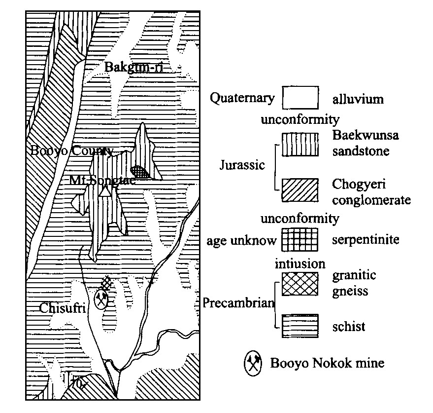
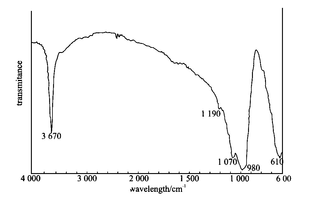
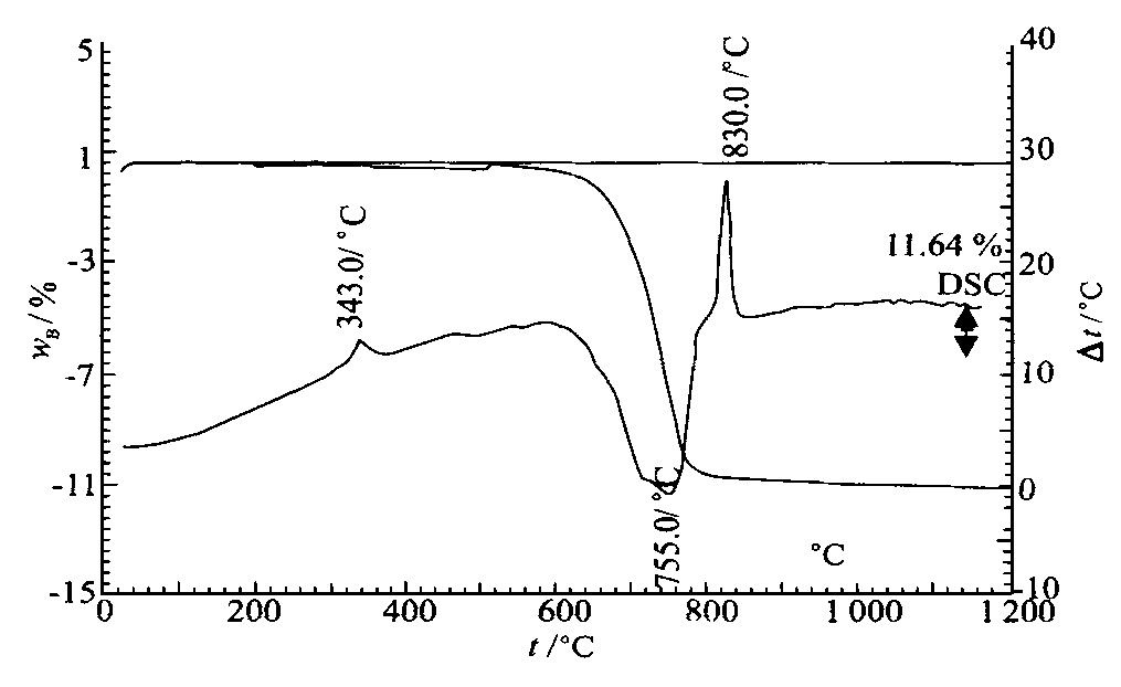
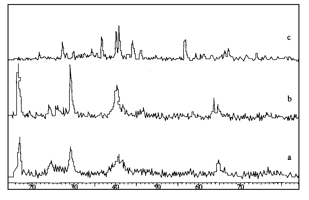
Dolomitization of Carbonate Periplatform Deposit, Machari Formation (Middle to Late Cambrian), Korea
Gong Soo Chung
2000, 11(2): 115-116.
Abstract:
Comparison in Landsat TM Land-Cover Data between Cholwon (South Korea) and Wonsan (North Korea)
Moo-Young Song, L RoseflfeId Charles
2000, 11(2): 116-117.
Abstract:
A New and Nontraditional Method to Locate Concealed Mineral Resources-Geogas Prospecting from Nuclear Analysis and Accumulation Sampling
Chunhan Tong, Juchu Li
2000, 11(2): 117-117.
Abstract:
Stable Isotopic Composition for Hydrothermal Vein Deposits, Southeastern Korea
Sang Jung Kim, Hyun Koo Lee
2000, 11(2): 118-118.
Abstract:
New Perspective of High-Pure Silicon
A I Konyukhov, B A Sokolov, N A Yasamanov
2000, 11(2): 119-120.
Abstract:
Mineral Resources and Their Comprehensive Utilization in China Sea
Hong Chen, Hongbin Wang
2000, 11(2): 120-121.
Abstract:
Genesis and Mineralogy of Serpentinite Deposits, West of South Korea
Suckhwan Song, Seon Gyu Choi, Hyun Kon Lee
2000, 11(2): 122-122.
Abstract:
Application of Thermoluminescence Techniques to Mineral Exploration—Principles and Advantages
Chi-Chieu Chen
2000, 11(2): 123-127.
Abstract:

The phenomena of TL are connected with the defect structures of the atomic lattice of the material concerned, and hence are very sensitive to changes in defection of the country rocks status as induced by the mineralizing solution. In other words, the TL of the country rocks from the mineralized area should be quite different from that in the intact barren area.Besides the high sensitivity as mentioned above, advantages of the application of TL techniques to the mineral exploration the easiness in accessing to proper samples, the easy preparation of samples and the quickness in sample processing all amount to convenience and economy of the techniques, indicating the high competitiveness of the TL mineral exploration method, especially during the development stage of mining operations.

Geochemical and Geophysical Data Processing Aided by "Multifractal-Spectrum" Filters for GIS-Based Mineral Exploration
Yaguang Xu, Qiuming Cheng
2000, 11(2): 128-130.
Abstract:

A recently developed method, on the bases of "multifractal spectrum" filters for mineral exploration, is introduced in this paper. The "multifractal spectrum" filters, a group of irregularly shaped filters that are constructed on each processed datum, can be used to separate various types of geochemical and geophysical anomalies. The basic model, with an emphasis on the GIS based implementation and the application to the geochemical and geophysical data processing for mineral exploration in southern Nova Scotia, Canada, indicates its advantage in the separation of multiple anomalies from the background.

GIS-Based Hydrogeological-Parameter Modeling
Shujie Han, Qiuming Cheng
2000, 11(2): 131-133.
Abstract:

A regression model is proposed to relate the variation of water well depth with topographic properties (area and slope), the variation of hydraulic conductivity and vertical decay factor. The implementation of this model in GIS environment (ARC/TNFO) based on known water data and DEM is used to estimate the variation of hydraulic conductivity and decay factor of different lithology units in watershed context.

Fuzzy Comprehensive Appraisal of Concealed Ore Deposits
Jun Deng, Yun Fang, Li Wan, Liqiang Yang, Jianping Wang, Chonghui Shen
2000, 11(2): 134-137.
Abstract:

In this paper, the transformation from the fuzzy to the accurate process is exemplified by the Jiaodong gold ore deposits concentrated region where the mathematical analysis is used to appraise and forecast regional concealed gold ore deposits. In this sense, this paper presents a new way to the appraisal of the non-traditional mineral resources.

GIS—A Tool to Change Traditional Way of Mineral Resources Appraisal
Keyan Xiao, Xiaohua Zhang, Zhenghui Chen, Yusheng Zhu, Guoyao Song
2000, 11(2): 138-140.
Abstract:

Because of the wide application of digital spatial information technology to geology, a large spatial database in geology, geophysics, geochemistry and remote sensing is constructed, resulting in a change in conditions, methods and targets of mineral resources appraisal (MRA). In this paper, the difference between the GIS base MRA and the traditional MRA is studied.

Theory of and Method for Nontraditional Mining Assessment
Hongqing Yang, Pengda Zhao, Wanheng Li
2000, 11(2): 141-143.
Abstract:
Comparison in Mineralization between Ferromanganese Nodules and Co-Rich Manganese Crusts in Pacific Ocean
Dongyu Xu, Ruyong Cui, Xinbo Liu
2000, 11(2): 144-145.
Abstract:
Distribution and Classification of Cobalt-Rich Crust
Dehua Liang, Benduo Zhu
2000, 11(2): 146-149.
Abstract:

Based on the on-the-spot investigation and related data, cobalt-rich crust is mainly distributed in the low latitude area near the equator, mostly within 20°S to 20°N, especially 5°-15°(S and N). The analysis of the microtopographic and microphysicognomy features shows that crusts are often present in the complicated topographic regions such as seamount slopes, convex parts of seamounts and joint faults, of which the ideal region is seamount slopes in water-depth of 1 500-2 500 m. The authors analyze the relation of the crusts and their bedrock, bedrock type, crust thickness and occurrence, and then attempt to classify the crusts as different types.

Regional Geochemical Division—A Tool for Delineating Geochemical Block
Chen Ming, Guangsheng Yan, Jizhang Fan, Jingchao Li
2000, 11(2): 150-153.
Abstract:

Regional geochemical division is a mapping technique to divide an area into slices where the associations between geochemical elements are relatively simple and uniform. The result of division is expressed on a 2 D map. The scheme of regional geochemical division includes non supervised pattern recognition, elementary statistics and factor analysis. A practical example in a gold prospecting area in Jilin, China, and the corresponding explanation are presented. Regional geochemical division is a basic approach to the delineation of the geochemical blocks as well.

Resources of Kaolinite Rocks in China Coal Measures
Qinfu Liu, Hongliang Xu
2000, 11(2): 154-157.
Abstract:

The proved reserve of kaolinite rocks in China coal measures is about 1.673 billion tons. The types of kaolinite rocks contain tonstein, flintclay and soft kaolin. Their origin modes include alteration of volcanic ash, terrigenous clay deposit and weathering of coal and adjacent rocks. The organic matter and organic acid play an important role in the formation of kaolinite rocks of coal measures. The difference in properties between kaolinite rock and traditional kaolin requires different processing technologies.

Delineation of Potential Mineral Resources Region Based on Geo-anomaly Unit
Yongqing Chen, Hongguang Liu
2000, 11(2): 158-163.
Abstract:

The geological anomaly unit method (GAUM) is a new way to delineate and evaluate ore finding targets in line with the "geological anomaly ore finding theory". Comprehensive ore finding information from geological, geochemical and geophysical data is used for quantitative measurement of the "ore forming geological anomaly unit" in this paper. The main procedures are shown as follows: (1) The geo anomalous events associated with gold mineralization are analyzed in Tongshi gold field; (2) The zonation in the concentrated heavy minerals and the stream sediment elements of ore forming geo anomaly are studied in detail; (3) The deep geological structural framework is deduced by means of the synthetic geological interpretation of gravity and magnetic information; (4) The ore controlling geo anomalies and ore anomalies are chosen as the variables of the favorable ore forming indexes that can be used for the quantitative delineation and evaluation of the potential ore forming regions.

Application of GIS to Geo-anomaly-Based Delineation of Mineral Resources
Shundu Chi, Pengda Zhao, Jianwei Li
2000, 11(2): 164-167.
Abstract:

In this paper, the Dongchuan type copper deposits are taken as an example to illustrate the application of GIS to the geo anomaly based delineation of mineral resources. The following eight steps are listed in this paper to delineate the permissive and preferable ore finding areas: (1) the analysis of favorable prospecting index using linear and planar geo anomalies; (2) the analysis of favorable prospecting index using combined anomalies; (3) the construction of a GIS based spatial model for mineral prognosis; (4) the delineation of the permissive ore finding area; (5) the determination of the synthetic anomalies and numerical range for the prediction of the favorable prospecting areas, and the determination of the weights of these two variables; (6) the superimposition of all the selected anomalies and the construction of the superimposition map; (7) the determination of unifying criterion of favorable prospective areas at various levels, and (8) the delineation of favorable prospective areas. Finally, this paper offers a detailed discussion of the results in the forecasting of Dongchuan type copper deposits.

Integrated Assessment of Mineral Resources and Environment in Mid-South of Shandong Province
Min Wei, Yonghui Yao, Xueping Wang
2000, 11(2): 168-170.
Abstract:

On the bases of the field survey and a large number of testing data, we process the qualitative and quantitative assessment of the mine environment in the mid south of Shandong Province using the following grade Ⅰ factors: the surface subsidence in mining area, the three wastes of mine industries, the pollution sources, the surface water pollution, the underground water pollution and the air pollution. By means of emitting factor judgment and water quality indexes, we locate pollution sources, main pollutants, pollution type and pollution grade in the study area. Using the MAPGIS, we draw a zonality map of the mine environment. This paper attempts to offer a concrete example, including valuable assessment method, data and conclusion, for the assessment of mine environment from the integrated assessment of mineral resources and mine environment. This research is oriented towards the sustainable development and the ecological environment optimization.

Mineral Features of Surface Sediments and Analysis of Solid-State Mineral Resources in Southeastern China Sea
Deli Du, Hong Chen, Shumin Wang, Hongjun Chen, Ling Wan
2000, 11(2): 171-174.
Abstract:

With the development of modern industry and the increase of human demand, it is increasingly important to prospect and exploit marine mineral resources. Based on the oceanic geological investigation references obtained from the regional geological surveying and mapping of China Sea ("Shantoufu, F 50" 1∶1 000 000) and on the data ("Marine Engineering Geological Investigation Project in the Pearl River Mouth basin in the South China Sea" 1∶200 000), the authors elaborate the grain size composition, mineral composition, mineral features and distribution pattern of the surface sediments in the sea at 114°-120°E and 20°-24°N. Moreover, the analysis of the regional solid state mineral resources in the coast of Fujian, Guangdong and the west of Taiwan, shows that the main resources include littoral/neritic placers, littoral/neritic sandy gravel and ferromanganese nodule (crust). In addition, the future focus should be on the placers and sandy gravels in this littoral area.

Duobaoshan Porphyry Copper Deposit and Its Associated Components
Xichen Wang, Jinying Liu, Chengyu Zhang, Fengshan Xu, Jun Deng, Dongfeng Tian
2000, 11(2): 175-178.
Abstract:
A GIS Approach to Prediction of Copper Deposits
Xinlin Wu, Shundu Chi
2000, 11(2): 180-182.
Abstract:

This paper describes three main parts of GIS technique used in prospecting of copper deposits. Firstly, this paper briefly introduces GIS technique for data preparation.Then it discusses the geoanomaly (GA) analysis and targets delineation methods, where the unit ore equivalent calculation of planar GA and the transformation and evaluation of linear GA are dominant.In addition, the method for copper prospecting is demonstrated.Finally a case study of copper-deposit prospecting in Yuanjiang, Yunnan Province is presented by the use of MAPGIS.

Application of GIS to Geological Information Extraction
Yu Cao, Guangdao Hu, Hongchao Ma
2000, 11(2): 183-185.
Abstract:

GIS, a powerful tool for processing spatial data, is advantageous in its spatial overlaying. In this paper, GIS is applied to the extraction of geological information. Information associated with mineral resources is chosen to delineate the geo anomalies, the basis of ore forming anomalies and of mineral deposit location. This application is illustrated with an example in Weixi area, Yunnan Province.

Two Kinds of Nontraditional Mining Technology
Lianggang Li, Fenglin Tang
2000, 11(2): 186-187.
Abstract:

The nontraditional mining industry is an important part of nontraditional mineral resources projects. It is a new mining industry focusing on the application of new science and technology, producing high value added outputs, offering comprehensive services, protecting the environment and saving energy sources. This paper discusses main principles of two kinds of nontraditional miming technology: the drilling hydraulic fracturing and drilling hydraulic mining applied to the coalbed methane production. Furthermore, this paper introduces the characteristics and application of these two kinds of technology.

Research into Exploitation and Application of Three Sorts of
Zhen Li, Shangyue Shen, bo Chi, De Zhang, Mei Yang
2000, 11(2): 188-189.
Abstract:

In this paper the authors introduce their past years'study results about the exploitation and application of three sorts of nontraditional nonmetal minerals. In this research, the main aspects and techniques of basic study for the exploitation and application are summarized, and some key science and technological problems are proposed as the objects of their future research.

Atomic—Scale Study of Mineral Luminescent Materials and Their Microstructures
Lin Cao
2000, 11(2): 190-190.
Abstract:
Dynamic Model of Mineralization Enrichment and Its Applications
Wei Shen
2000, 11(2): 191-193.
Abstract:

This paper studies the chaos dynamic mechanism of the migration, enrichment and mineralization of elements in the crust. The research shows that the interaction of the nonlinear process in the geological environment is an essential factor for the uneven distribution of elements and the mineralization in the crust, determining the element contents and the fractal structure of the distribution of the large and small sized mineral deposits. The logistic map is a better mathematical model describing the behavior of the chaos dynamic. The parameter μ, i.e., the mineralizing potential, is employed to divide the region into non mineralization region or mineralization region. The value of the parameter μ in model (3) with true data (in Xinjiang Au tomatio region, China) is obtained with the statistical method. The forecasting results are generally in accordance with those obtained with other methods, for example, with the characteristic analysis.