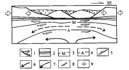
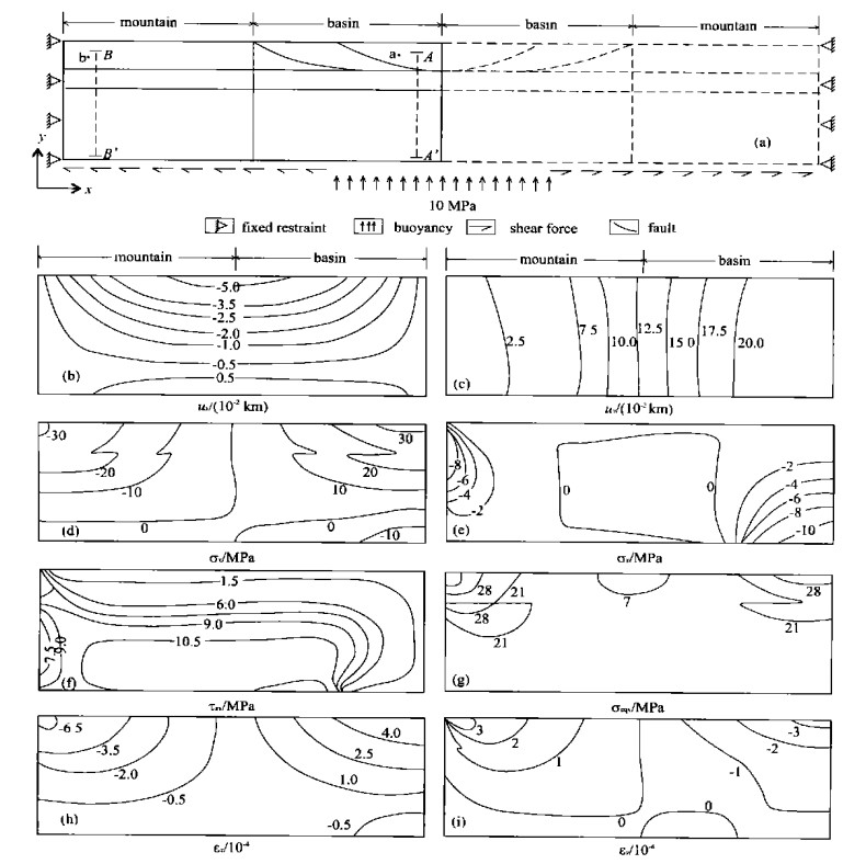
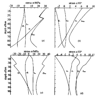
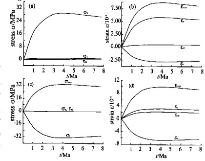
Advanced Search

Indexed by SCI、CA、РЖ、PA、CSA、ZR、etc .

2003 Vol. 14, No. 4

Display Method:
Research
Crystal Chemistry Research of Minerals of Nigerite Group and Its Significance
Jingzhong Chen, Fang Wang, Wei Han, Ronghong Zhang, Jue Peng
2003, 14(4): 293-299.
Abstract:

There is a type of complex oxide mineral, composed of many elements such as Sn, Mg, Fe, Zn, Ti, Mn, Al, etc., in the areas of Anhua, Linwu and Shizhuyuan of Hunan Province. These minerals belong to nigerite, Mg-nigerite (pengzhizhongite), etc.. According to the principle of closest packing, the crystal chemical properties of nigerite (brown), pengzhizhongite (buff), Zn-nigerite (fawn), Fe-nigerite, Mn-nigerite (greenish-black) etc. have been analyzed. Their crystal structures may be characterized by O (the layers of cation octahedral coordinations), T1 (the mixed layers of cation octahedral coordinations and cation tetrahedral coordinations in same directions), T2 (the mixed layers of cation octahedral coordinations and cation tetrahedral coordination in different directions). The position of layer-O and layer-T is alternate permutation. The crystal structure of pengzhizhongite (6H) may be expressed by …OT2OT1OT1…, taaffeite (8H), …OT2OT1OT2OT1…, and nigerite (24R), … OT1OT2OT2OT1 …×3 etc.. In their structure, there are not only the crystal structure units of spinel … OT2 OT2 … but also the units of nolanite … OT1 OT1 …. The research of these minerals has important theoretic and practical significance in the fields of minerals, gemology, material science etc..

Exploring Physical Indicators for Carbonate Contents in Deep Sea Sediments
Huang Wei, Zhifei Liu, Xiaoliang Chen, Pinxian Wang
2003, 14(4): 300-305.
Abstract:

To determine carbonate contents of deep sea sediments using physical properties is an enjoyable and efficient paleoceanographic way, which has been processed successfully in many studies based on a low resolution, but rather than a high one. A series of mathematical methods including the least square method were used in this study to build multiple regression equations between color reflectance and carbonate content, and between magnetic susceptibility and carbonate content, based on the data of color reflectance and magnetic susceptibility collected via the ODP Leg 184 cruise, as well as measured carbonate contents. We found that percent carbonate estimated with diffuse reflectance is closer to the measured one than that estimated with magnetic susceptibility, and the multiple regression equation is varied in different sites.

Morphological Variation of Conodonts Platyvillosus from Yinkeng Formation in Chaohu, Anhui Province, China
Laishi Zhao, Jinnan Tong, Michael J Orchard
2003, 14(4): 306-313.
Abstract:

A preciously undescribed Lower Triassic sequence of a series of multiple cycles of mud-lime rocks, with the argillaceous content decreasing upward while limestone becomes the dominant lithology in the upper part, contains abundant fossils such as conodonts, ammonoids and bivalves. The Yinkeng Formation is the oldest Triassic unit represented, and it conformably overlies dark-gray thin-bedded argillaceous silicalite and intercalated grayish illite clay interbeds of the Upper Permian of Dalong Formation. Conodont samples collected from west Pingdingshan Section, one of four measured sections in Chaohu, yielded abundant Lower Triassic conodonts from the middle part of the Yinkeng Formation. Most interesting and unusual is the abundant occurrence of Platyvillosus in seven samples from the Flemingites-Euflemingites bearing (Smithian) mudstone, rhyolitic clay and limestone part of the section. The associated conodonts are Neospathodus dieneri type 1, N. dieneri type 2, N. dieneri type 3, N. cristagalli, N. waageni eowaageni (nov. subsp.), N. waageni elongata (nov. subsp.), N. waageni waageni, N. sp. G (nov. sp.), N. sp. L (nov. sp.), N. sp. H (nov. sp.), N. alberti, N. novaehollandiae, N. peculiaris, N. aff. discretus, N. conservativus, Parachirognathodus sp. and ramiform elements. The species Platyvillosus, which is restricted to a 1.32 m interval, reveals great variety in shape and denticle ornamentation pattern on the platform. The morphological study of the samples indicates that all speciemens with denticles on the upper surface can be included in intraspecific variation in Platyvillosus costatus (Staesche). Platyvillosus hamadai (Koike), marked by smooth upper surface, also appears to be connected by transitional forms in some samples. The fauna corresponds closely with that of the Taho limestone in Japan, although the depositional environments differ. The associated lithologies of the Yinkeng Formation within Chaohu area reflect a deeper and low energy remaining basin of the northern edge of the Lower Yangtze block.

Characteristics of Albaillella (Albaillellarian, Radiolarian) Fauna from Guadalupian to Lopingian Series in Permian, South China
Dongying Sun, Wenchen Xia
2003, 14(4): 314-320.
Abstract:

On the basis of establishment of radiolarian biostratigraphy and conodont biostratigraphy, a radiolarian Albaillella fauna in the transitional environment from Guadalupian to Lopingian Series in Permian was found at a pelagic chert section in southeast Guangxi, South China. Radiolarian Albaillella is one of the most sensitive biology to the transitional environment. The Albaillella fauna shows an ecological evolutionary process from Guadalupian to Lopingian: declined stage-recovery stage-flourishing stage. The study of characteristics of the Albaillella fauna in the transitional environment may provide more information, not only for the subdivision and correlation of a high-resolution biostratigraphy, but also for influence of radiolarian Albaillella fauna on the pre-Lopingian mass extinction.

Geochemical Characteristics of Pb Isotope of High-Pressure Metamorphic Rocks and Foliated Granites from HP Unit of Tongbai-Dabie Orogenic Belt
Zhang Li, Hongfei Zhang, Zengqiu Zhong, Benren Zhang, Linsen Wang
2003, 14(4): 321-329.
Abstract:

Whole-rock Pb isotopic compositions of the high-pressure (HP) metamorphic rocks, consisting of two-mica albite gneisses and eclogites, and foliated granites from the HP metamorphic unit of the Tongbai-Dabie orogenic belt are firstly reported in this paper. The results show that the HP metamorphic rocks in different parts of this orogenic belt have similar Pb isotopic compositions. The two- mica albite gneisses have 206Pb/204Pb=17.657-18.168, 207Pb/204Pb=15.318-15.573, 208Pb/204Pb=38.315-38.990, and the eclogites have 206Pb/204Pb=17.599-18.310, 207Pb/204Pb=15.465- 15.615, 208Pb/204Pb=37.968-39.143. The HP metamorphic rocks are characterized by upper crustal Pb isotopic composition. Although the Pb isotopic composition of the HP metamorphic rocks partly overlaps that of the ultrahigh-pressure (UHP) metamorphic rocks, as a whole, the former is higher than the latter. The high radiogenic Pb isotopic composition for the HP metamorphic rocks confirms that the subducted Yangtze continental crust in the Tongbai-Dabie orogenic belt has the chemical structure of increasing radiogenic Pb isotopic composition from lower crust to upper crust. The foliated granites, intruded in the HP metamorphic rocks post the HP/UHP metamorphism, have 206Pb/204Pb=17.128-17.434, 207Pb/204Pb=15.313-15.422 and 208Pb/204Pb=37.631-38.122, which are obviously different from the Pb isotopic compositions of the HP metamorphic rocks but similar to those of the UHP metamorphic rocks and the foliated garnet-bearing granites in the UHP unit. This shows that the foliated granites from the HP and UHP units have common magma source. Combined with the foliated granites having the geochemical characteristics of A-type granites, it is suggested that the magma for the foliated granites in the UHP and HP unit would be derived from the partial melting of the retrometamorphosed UHP metamorphic rocks exhumed into middle to lower crust, and partial magmas were intruded into the HP unit.

Rheological Simulating Study of Mechanical Conditions for Syn-extensional Basin and Mountain Coupling System
Hongling Wu, Xiulan Yin
2003, 14(4): 330-338.
Abstract:

This article gives a mechanical model, in which the layers of lithosphere are assumed to be the creep materials, to study the coupling mechanism of a syn-basin-mountain system quantitatively by using the numerical simulating method.A geological dynamic extensional mode given by some geologists is theoretically discussed and verified.The study shows that lithosphere thickening or thinning is closely related to the thermal activity, or in other words, thermal convection beneath the lithosphere.It is one of the important factors affecting the formation of the basin-mountain coupling system.As an essential condition, only the upward buoyant force and the horizontal dragging force caused by the thermal convection jointly act on the bottom of the lithosphere, the stress and strain states in rock's layers are advantageous to forming the tectonic-landforms of the basin-mountain coupling system.A study on the creep features of the lithosphere shows that the stress and strain in the rock's layers vary with time when the lasting forces act on the boundary.They increase rapidly at initial stage and decrease steadily after reaching the peak value.Phenomena of stress relaxation are significant for studying the tectonic evolution.

Dating Magmatic Hornblende and Biotite and Hydrothermal Sericite by Laser Probe Technique: Constraints on Genesis of Wangershan Gold Deposit, Eastern Shandong Province, China
Jianwei Li, P M Vasconcelos, M F Zhou, N S Duzgoren-Aydin
2003, 14(4): 339-348.
Abstract:

The Wangershan gold deposit and spatially related Shangzhuang granite, eastern Shandong Province, have been precisely dated by 40Ar/39Ar laser incremental heating technique. Magmatic hornblende and biotite, collected from the Shangzhuang granites, yielded well-defined and reproducible plateau ages at 128.1-127.5 and 124.4-124.1 Ma (2σ), measuring the cooling ages of the intrusion at ca. 500 ℃ and 300-350 ℃, respectively. Hydrothermal sericite extracted from auriferous vein gave high-quality plateau ages between (120.6±0.3) Ma and (120.0±0.4) Ma (2σ). Given the similarity of the closure temperature for argon diffusion (300-350 ℃) in the sericite mineral to the homogenization temperature of primary fluid inclusions in the quartz from gold ores, and the intergrowth of sericite with native gold, present 40Ar/39Ar sericite ages can be reliably interpreted in terms of the mineralization age for the Wangershan deposit. 40Ar/39Ar hornblende and biotite ages permit an estimate for the cooling rate of the Shangzhuang granite at about 50 ℃/Ma. There are abundant intermediate-mafic dikes in most gold camps of eastern Shandong, whose ages of formation have been previously constrained mainly at 121-119 Ma. The temporal association between the Shangzhuang granite, the Wangershan gold deposit, and the widespread dikes confirms that intrusive activity, gold mineralization, and dike emplacement in this region were broadly coeval, reflecting significant continental lithosphere thinning and resulting crustal extension of Early Cretaceous in eastern China.

Copper-Polymetal Metallogenic Series and Prospecting Perspective of Eastern Section of Gangdise
Youye Zheng, Yingxi Xue, Shunbao Gao
2003, 14(4): 349-355.
Abstract:

Geological, geophysical, geochemical and remote sensing comprehensive studies show that big ore-prospecting potentiality is contained in the eastern section of the Gangdise Mountains, Tibet. There are various mineralization types with dominant types of porphyry and exhalation. According to their relations with tectonic evolution, they are divided into four kinds of metallogenic series as follows: magmatic type (Cr, Pt, Cu, Ni) and exhalation type (Cu, Pb, Zn, Ag) ore deposit series related to Neo-Tethys oceanic crust subduction action (125-96 Ma); epithermal type (Au, Ag, Pb, Zn, Sb), altered fractured rock type (Cu, Mo) and skarn rock type (Cu) ore deposit series related to arc-continental collision; porphyry type (Cu, Mo), cryptoexplosion breccia type (Cu, Au, Pb, Zn), shear zone type (Au, Ag, Sb) and skarn rock type (Cu, Fe) ore deposit series with relation to post-orogenic extensional strike-slip. From subductive complex to the north, zoning appears to be crystallization differentiation type (segregation type)-shear zone type (altered rock type)-skarn rock type, epithermal type-porphyry type-porphyry type and exhalation type-exhalation type-hydrothermal filling-replacement type. The ore deposit is characterized by multi-places from the same source, parity and multi-stage, hypabyssal rock from the deep source and poly genetic compound as a whole.

Using Remote Sensing and GIS Techniques to Study Soil Degradation Processes in North Shaanxi Province, China
Mushtak Talib Jabbar
2003, 14(4): 356-362.
Abstract:

Satellite image data and thematic map data were used to provide comprehensive views of surface-bound conditions such as soil and vegetation degradation.The current work applies a computerized parametric methodology, developed by FAO, UNEP and UNESCO to assess and evaluate soil degradation at1∶250000 mapping scale.The study area is located in the arid and sem-i arid zone of the northern part of Shaanxi Province in China, a region with considerable agricultural potential; Landsat TM images were utilized to provide recent data on land cover and use of the area.ARC/INFO and ArcView softwares were used to manage and manipulate thematic data, to process satellite images, and tabular data source.ER mapper software is utilized to derive the normalized difference vegetation index (ND VI) values while field data to estimate soil erodibility (SE) factor.A system is established for rating soil parameters, slope, climate factor and human factor activity.The rating values serve as inputs into a modified universal soil loss equation (USLE) to calculate the present state and risk for soil degradation processes, namely soil wind erosion.The produced maps and tabular data show the risk and the present status of different soil degradation processes.The study area, in general, is exposed to high risk of wind erosion and high hazards of water erosion.Several desertification maps were produced, which reflect the desertification types persisting in the study area.Wind erosion, water erosion, vegetation degradation, physical degradation and salinization are the basic desertification maps, and others are combinations of these basic maps.In terms of statistic analysis, 33.75% of the total land area (120.3300ha) is considered as sand or sand dune, and not included in our analysis of desertification.About29.41% of the total land area has slight or moderate desertification and37.465% is facing severe desertification.

Datum Level and NMO Corrections to Shallow Seismic Reflection Data on Rugged Topography
Jiangping Liu, Jianghai Xia, Chao Chen, Suxin Zhang
2003, 14(4): 363-367.
Abstract:

The application of the seismic reflection method is often limited in complex terrain areas. The problem is the incorrect correction of time-shift caused by topography.To apply normal moveout (NMO) correction to reflection data correctly, static corrections are necessary to be applied in advance for the compensation of the time distortions of topography and the time-delays from near-surface weathered layers.For environment and engineering investigation, weathered layers are our targets so that the static correction mainly serves the adjustment of time-shift due to an undulating surface.In practice, seismic reflected raypaths are assumed to be almost vertical through the near-surface layers because they have much lower velocities than layers below.This assumption is typically acceptable in most cases since it results in little residual error for small elevation changes and small offsets in reflection events.Although static algorithms based on choosing a floating datum related to common midpoint gathers or residual surface-consistent functions are available and effective, errors caused by the assumption of vertical raypaths often generate pseudo indications of structures.This paper presents the comparison of applying corrections based on the vertical raypaths and bias (non-vertical) raypaths.It also provides an approach of combining elevation and NMO corrections.The advantages of the approach are demonstrated by a synthetic example of multi- coverage seismic reflection surveys on rough topography.

Vertical Electrical Sounding Investigation in East River Nile Area (Khartoum State), Sudan
M G Eldawi, A G Farwa, Tianyou Liu
2003, 14(4): 368-373.
Abstract:

Vertical electrical sounding (VES) was carried out in the east of the River Nile.The main objectives of the resistivity survey are to determine the types and thicknesses of sedimentary units in the area, to define the contact separating the sediments from the crystalline basement complex, and to determine the structural features of the subsurface formations.Several local depressions, whose maximum depth to the basement surface is about160m, are revealed as an outcome of the VES method, and suggested to have been infilled with undifferentiated units of the Nubian Group in particular Omdurman Formation.Thus, a depth to the basement complex is calculated and the associated structural map of the east of the River Nile is drawn.The map is useful for the groundwater drilling, as far as the presence or absence of the aquifer is concerned.

Researches on Cartographic Database-Based Interactive Three-Dimensional Topographic Map
Wenping Jiang, Daping Xi
2003, 14(4): 374-380.
Abstract:

With the development of computer graphics, the three-dimensional (3D) visualization brings new technological revolution to the traditional cartography.Therefore, the topographic3D-map emerges to adapt to this technological revolution, and the applications of topographic3D-map are spread rapidly to other relevant fields due to its incomparable advantage.The researches on digital map and the construction of map database offer strong technical support and abundant data source for this new technology, so the research and development of topographic3D-map will receive greater concern.The basic data of the topographic3D-map are rooted mainly in digital map and its basic model is derived from digital elevation model (DEM) and3D-models of other DEM-based geographic features.In view of the potential enormous data and the complexity of geographic features, the dynamic representation of geographic information becomes the focus of the research of topographic 3D-map and also the prerequisite condition of 3D query and analysis.In addition to the equipment of hardware that are restraining, to a certain extent, the3D representation, the data organization structure of geographic information will be the core problem of research on 3D-map.Level of detail (LOD), space partitioning, dynamic object loading (DOL) and object culling are core technologies of the dynamic 3D representation.The objectselection, attribute-query and mode-l editing are important functions and interaction tools for users with 3D-maps provided by topographic3D-map system, all of which are based on the data structure of the3Dmodel.This paper discusses the basic theories, concepts and cardinal principles of topographic3D-map, expounds the basic way to organize the scene hierarchy of topographic3D-map based on the node mechanism and studies the dynamic representation technologies of topographic 3D-map based on LOD, space partitioning, DOL and object culling.Moreover, such interactive operation functions are explored, in this paper, as spatial query, scene editing and management of topographic3D-map.Finally, this paper describes briefly the applications of topographic3D-map in its related fields.

Research on Algorithm for Generating Min-Area Rectangle Encasing Box for Closed Contour
Qinghua Li, Guangming Dai, Maocai Wang
2003, 14(4): 381-384.
Abstract:

In many engineering applications, it is necessary to calculate the min-area encasing box of a circumscription.In this paper, an algorithm for generating the min-area rectangle encasing box, based on revolving angle, is investigated and hence put forward.The algorithm computes the areas of the outer rectangular bounds of a closed contour in different revolving angles θby dispersing approach where 0 <θ<π/ 2 because of the axial symmetry.It is very simple, straight forward and highly efficient.The complexity of its computing time reachesO(n·k).Practical applications suggest its usefulness and efficiency.

Developing Universities into Learning Organizations
Zhongmei Cheng, Shuqin Cai
2003, 14(4): 385-387.
Abstract: