Advanced Search

Indexed by SCI、CA、РЖ、PA、CSA、ZR、etc .

2013 Vol. 24, No. 2

Display Method:
Research
Guadalupian (Middle Permian) Radiolarian and Sponge Spicule Faunas from the Bancheng Formation of the Qinzhou Allochthon, South China
Ito Tsuyoshi, Lei Zhang, Qinglai Feng, Matsuoka Atsushi
2013, 24(2): 145-156. doi: 10.1007/s12583-013-0317-2
Abstract:
The Gujingling (古井岭) Section in Xiaodong (小董), Guangxi (广西) Zhuang Autonomous Region, China, consists of cherts and siliceous siltstones, which belongs to the Bancheng (板城) Formation of the Qinzhou (钦州) allochthon. Three successive radiolarian assemblage-zones related to the Guadalupian (Middle Permian) appear in the section in the following ascending order: Pseudoalbaillella sp. aff. Pseudoalbaillella longicornis-Pseudoalbaillella fusiformis, Follicucullus monacanthus, and Follicucullus scholasticus-Follicucullus porrectus. The radiolarian content in this section is generally greater than that of sponge spicules. The radiolarian fauna commonly consists of abundant Albaillellaria and spherical radiolaria with minor Latentifistularia and Entactinaria. The sponge fauna is composed mainly of hexactinellids with minor demosponges. These siliceous fossil faunal features, comparable with those in a deep basin of the western belt of the Phosphoria Basin in the western United States, indicate that the Bancheng Formation in the Gujingling Section was deposited in a basin deeper than 1 000 m. The siliceous siltstones in the section are characterized by inclusion of silt-sized quartz and no inclusion of sand-sized materials, suggesting that the Gujingling Section was located at least a few hundred kilometers from the South China Block in the Guadalupian.
Middle Cambrian (Upper Series 3) Protoconodonts and Paraconodonts from the Machari Formation at Eodungol Section, Yeongwol, Korea
Byung-Su Lee
2013, 24(2): 157-169. doi: 10.1007/s12583-013-0318-1
Abstract:
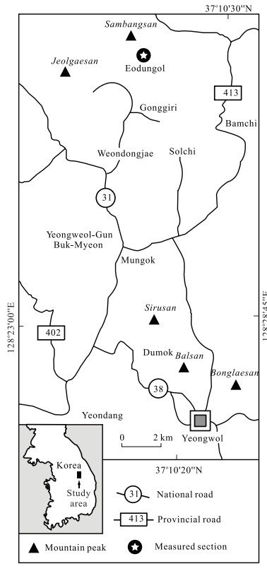
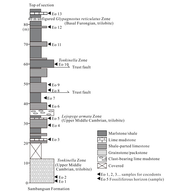
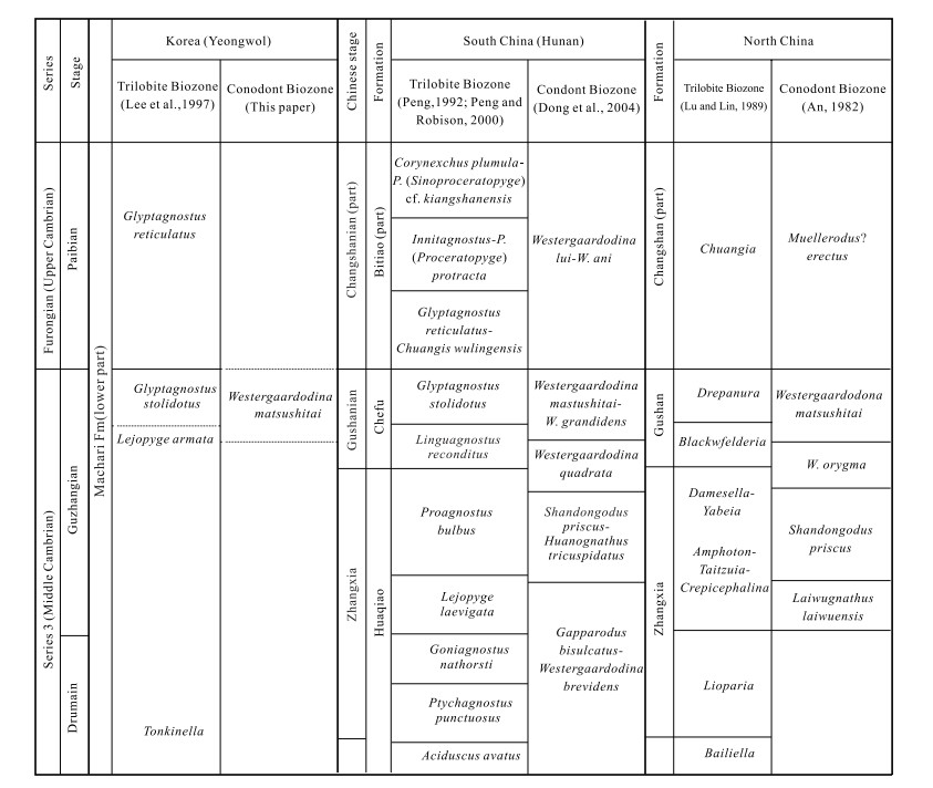
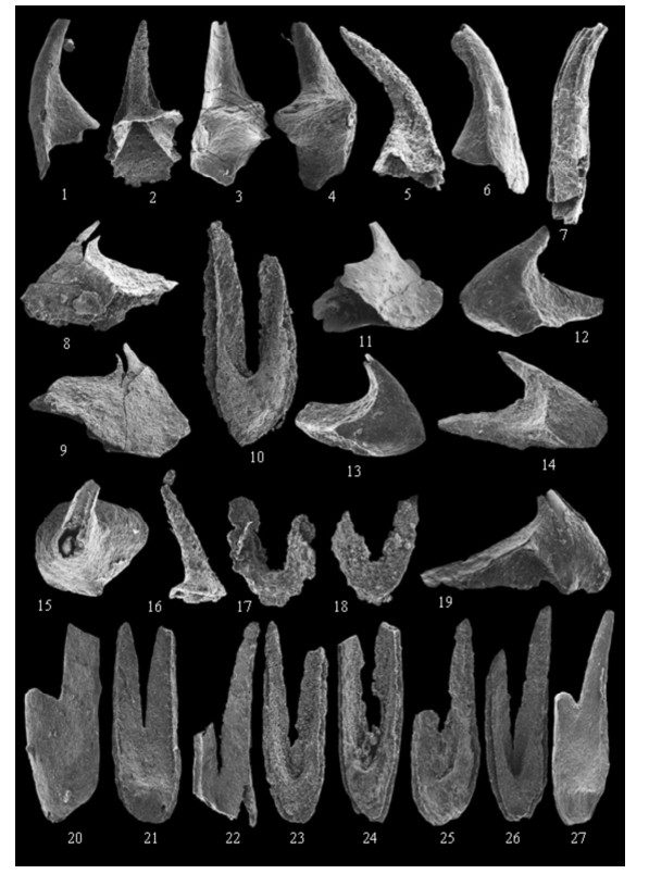
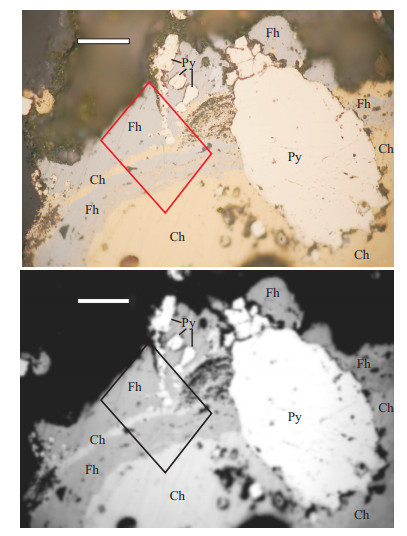
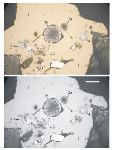
The Machari Formation ranges from the "upper Series 3" (Middle Cambrian) to Furongian (Upper Cambrian) in the Yeongwol area, Korea. It has been known to yield relatively diverse invertebrate fossils. Particularly, the trilobite biozones of the formation have been well defined. On the other hand, little has hitherto been studied on conodont microfossils for the formation. This paper reports a diverse and well-preserved protoconodonts and paraconodonts of Series 3 from the formation in the Eodungol Section, exposed along a southern mountain trail of Mt. Sambangsan, Yeongwol, Korea. Five of the 13 samples collected for conodont contain a rich protoconodont and paraconodont assemblage and numerous shelly fossils including trilobites, brachiopods, sponge spicules, hyolithids, and incertae sedis. Sample Eo 5 is extremely fossiliferous (465 elements, 96.5% of total collection), and the most abundant species was Phakelodus elongatus (236 elements, 62% of the Eo 5 collection). The preservation is relatively good, but some specimens are corroded and fragmentary. Some of the protoconodonts are exfoliated. Relatively larger ones were commonly preserved as phosphatized internal molds, particularly in specimens of Furnishina bigeminata, Furnishina leei n. sp., Muellerodus pomeranensis, Nogamiconus sinensis, and westergaardodids. Phakelodids were commonly preserved as clusters. Among 20 species referable to nine genera, Furnishina bigeminata, Furnishina leei n. sp., Nogamiconus sinensis, Huayuanodontus tricornis, Proscandodus obliquus, and Westergaardodina grandidens were previously undescribed species in Korea. This assemblage is named herein as the Westergaardodina matsushitai Zone, which is a new biozonal name replacing the old one, i.e., Gapparodus bisulcatus-Westergaardodina matsushitai-Westergaardodina moessebergensis Assemblage. The W. matsushitai Zone corresponds to the Lejopyge armata trilobite Zone and is well correlated with the upper Series 3 conodont biozones of the Westergaardodina matsushitai-Westergaardodina grandidens Zone of South China and the Westergaardodina matsushitai Zone of North China, respectively. The present data allow a useful correlation to China and Baltica in relation to new subdivision of the Cambrian. Furnishina leei n. sp. is newly described.
Environmental Evolution of the South Margin of Qaidam Basin Reconstructed from the Holocene Loess Deposit by n-alkane and Pollen Records
Shuyuan Xiang, Fangming Zeng, Guocan Wang, Jianxin Yu
2013, 24(2): 170-178. doi: 10.1007/s12583-013-0320-7
Abstract:
This study provides the n-alkane and pollen records of the Holocene loess at Balong (巴隆) Town, Dulan (都兰) County, Qinghai (青海) Province, and the environmental changes reconstructed from both records agreed well. Three stages of past climate change were deciphered by variations of the n-alkane and pollen proxies. Before 5 370 a BP, the climate was warm-dry but slightly humid, corresponding to the Mid-Holocene climatic optimum; 5 370–3 830 a BP, the climate changed alternatively between warm-dry slightly humid and warm-dry, indicating the transition from the Mid-Holocene climatic optimum to the Late Holocene cold period; after 3 830 a BP, the climate was mainly warm-dry. The warm cool and extremely dry climate during 3 040–2 600 a BP was recorded by both the n-alkane and pollen proxies, suggesting the environment evolved into desert or salt lake, in accordance with the cold and highly frequent natural disaster period in the Western Zhou Dynasty (ca. 2 996–2 721 a BP) in China.
Microheterogeneity of the Koupol Deposit Fahlores as a Reflection of Changing of Physicochemical Parameters of the Ore-forming Solution
Igor'V Kemkin, Raisa A. Kemkina
2013, 24(2): 179-187. doi: 10.1007/s12583-013-0321-6
Abstract:
New data on a zonal structure of the Koupol deposit fahlores grains are given, and features of their chemism are shown. The fahlores chemical composition within the zones evolves from essentially arsenious (Fe-tennantite and Zn-tennantite), through mixed fahlores (Zn-tennantite-tetrahedrite arsenious and Zn-tennantite-tetrahedrite antimonous), to essential antimonous (Ag-bearing Zn-tetrahedrite). Varying chemical composition manifested as mineralogical-geochemical zonation of the fahlores grains is caused by changes of physicochemical conditions of the ore forming process during the time.
Re-Os Dating of the Suoerkuduke Cu (Mo) Deposit, Fuyun County, Xinjiang, and its Geodynamic Implications
Xiujin Liu, Wei Liu
2013, 24(2): 188-202. doi: 10.1007/s12583-013-0322-5
Abstract:
The Suoerkuduke (索尔库都克) Cu (Mo) deposit, in the same metallogenic belt with Xilekuduke (希勒库都克) Cu-Mo deposit, is located in the Armantai (阿尔曼太) island arc belt on the northern margin of East Junggar, Northwest China. Rhenium and osmium isotopic analysis of seven molybdenite samples from the deposit was used to determine the age of mineralization. A seven-point isochron age of 317.7±7.6 Ma, which is consistent, within analytical error, with the average model age of 323.3±1.9 Ma indicates that this deposit was formed at transitional period between the Early and Late Carboniferous. This age is obviously later than that of the Lower Devonian Tuoranggekuduke (托让格库都克) Formation acting as the wall rock but contemporaneous with the early stage of plutonism (330–268 Ma) in East Junggar. Based on the characteristics of mineralization age and tectonic setting of many typical deposits on the northern margin of East Junggar, we proposed that the mineralization age of Suoerkuduke deposit is a key period of East Junggar for the tectonic regime transforming from compression to extension and also the time when granitoids and deposits widely spread in this area. Mineralization and formation of skarn in this deposit are closely related to felsic-intermediate magmatism. The distinct characteristic from typical skarn-type deposits is that the metallogenic parent intrusion is a huge batholith in the depth. The Cu (Mo) mineralization, moyite, and granite porphyry are all derived products of the batholith.
Characteristics of Ore-Forming Fluid in the Zhenyuan Gold Orefield, Yunnan Province, China
Yan Zhao, Qingfei Wang, Xiang Sun, Gongjian Li
2013, 24(2): 203-211. doi: 10.1007/s12583-013-0323-4
Abstract:
The Zhenyuan (镇沅) gold orefield is located in the Ailaoshan (哀牢山) gold belt, Sanjiang (三江) metallogenic region, China. The fluid inclusions (FIs) in mineralized quartz samples, collected from four deposits, i.e., Laowangzhai (老王寨), Donggualin (冬瓜林), Kudumu (库独木), and Daqiaoqing (搭桥箐), in the orefield, were studied to reveal ore-forming process. Only aqueous-type and H2O-NaCl-type FIs were observed in the samples. Two generations of FIs are identified due to the spatial occurrences of FIs in host minerals. The early generation is located in the internal zone of quartz crystal, and it has higher homogenization temperatures varying from 180 to 255 ℃ and salinities ranging from 8.7% to 11%; the late generation, often with beating bubbles under room temperature, is developed in the quartz margin, its homogenization temperatures is lower within 95 to 160 ℃. After elimination of the late generation of FIs, early generation FIs compositions were tested. Gaseous phases in the FIs were H2O and CO2, with low contents of N2, CH4, and C2H6, and the liquids mainly contains Na+, K+, Ca2+, Mg2+, Cl, and SO42−. The reappraisal of the previously published hydrogen and oxygen isotope results suggested that the early generation of ore-forming fluid was mainly primary magma hydrothermal, while the late generation fluid contains large amounts of meteoric water. Thus, the result showed that Zhenyuan gold orefield may differ from typical orogenic deposits, which contains abundant CO2-dominated FIs. The two generations FIs developed as quartz grew displaying a continuous evolution of the ore-forming fluids.
Distribution of Cambrian Salt-Bearing Basins in China and Its Significance for Halite and Potash Finding
Shuli Wang, Mianping Zheng, Xifang Liu, Xinsheng Niu, Wenxi Chen, Kui Su
2013, 24(2): 212-233. doi: 10.1007/s12583-013-0319-0
Abstract:
Wide distribution of Cambrian salt-bearing basins is a prominent feature of older strata in Asia. The Cambrian salt-bearing sequences are mainly distributed in East Siberia of Russia, Iran, Oman, India, Pakistan, and China. The Cambrian was one of the most important epochs of potash deposition in the world. Potash salts are found in East Siberia, Iran, India, and Pakistan, and, among them, one of the largest potash deposits in the world—the Siberian Nepa Potash Basin-formed in the Early Cambrian. The Cambrian was also one of the most important epochs of rock gypsum and salt deposition in China. Gypsum deposits occur in all the three major continental blocks of China (Yangtze Block, North China Block, and Tarim Block), forming four large marine salt-bearing basins. Extensive, thick rock salt deposits have been found in the Yangtze Block and Tarim Block, where better potash-bearing hydrochemical manifestations and leaching coefficient anomalies have been found for the first time. In the North China Block, a number of gypsum deposits and occurrences have been observed and Cambrian high-salinity brine and halite crystals found in oil wells. This study for the first time relatively completely analyzes the distribution and tempo-spatial evolution of Cambrian gypsum and salt-bearing basins in China, which provide an important basis for the study of the history of Cambrian paleogeographic evolution over the globe and salt and potash exploration in Cambrian salt-bearing basins of China.
Estimating the Characteristics of Runoff Inflow into Lake Gojal in Ungauged, Highly Glacierized Upper Hunza River Basin, Pakistan
Shiqiang Zhang, Min Xu, Junli Xu, Qiudong Zhao, Stefan Hagemann
2013, 24(2): 234-243. doi: 10.1007/s12583-013-0324-3
Abstract:
Motivated by the potential flood outburst of Lake Gojal in the ungauged highly glacierized (27%) upper Hunza River Basin (HRB) in Pakistan that was dammed by a massive landslide on 4 January 2010, we attempt to analyze the characteristics of water inflow to the lake employing remote sensing data, two hydrological models, and sparsely observed data. One of the models (Model Ⅰ) is a monthly degree-day model, while another (Model Ⅱ) is the variable infiltration capacity (VIC) model. The mixture of glacier runoff output from Model Ⅰ and runoff over unglacierized areas calculated by Model Ⅱ has a similar seasonal variation pattern as that estimated from data recorded at a downstream station. This suggests that glacier runoff is the main source (87%) of runoff inflow into the lake. A sensitivity analysis suggests that the water inflow to the lake is highly sensitive to an increase in air temperature. Runoff in May is predicted to sharply increase by 15% to more than two-fold if the air temperature increases by 1 to 7, but it is predicted to increase only from 9% to 34% if the precipitation increases by 10% to 40%. The results suggested that the water inflow into Lake Gojal will not sharply rise even if there is heavy rain, and it needs to be in caution if the air temperature sharply increases. Analysis on long-term air temperature record indicates that the water inflow into the lake in May 2010 was probably less than average owing to the relatively low air temperature. Consequently, the flood outburst did not occur before the completion of the spillway on 29 May 2010.
Taiwan' Chi-Chi Earthquake Precursor Detection Using Nonlinear Principal Component Analysis to Multi-Channel Total Electron Content Records
Jyh-Woei Lin
2013, 24(2): 244-253. doi: 10.1007/s12583-013-0325-2
Abstract:
This research uses eigenvalue characteristics of nonlinear principal component analysis (NLPCA) and principal component analysis (PCA) to investigate total electron content (TEC) anomalies associated with Taiwan's Chi-Chi earthquake of 21 September 1999 (LT) (Mw=7.6). The transforms are used for ionospheric TEC from 01 August to 20 September 1999 (local time) using data from 13 GPS receivers. The data were collected at 22°N–26°N Lat. and 120°E–122°E Long.. Applying the NLPCA to the multi-channel total electron content records of GPS receivers, the earthquake-associated TEC anomalies were represented by large principal eigenvalues of NLPCA (> 0.5 in a normalized set) on 14 August and 17, 18, and 20 September, with allowance given for the Dst index, which was quiet for the study period. Comparisons were then made with other researchers who also found TEC anomalies on September 17, 18, and 19 associated with the Chi-Chi earthquake, which cannot be detected by PCA. Consideration is also given for reported ground level geomagnetic field activity that occurred between mid-August and late October, leading up to and including the Chi-Chi and Chia-Yi earthquakes, which are associated with the same series of faults. It is possible that Aug. 14 is representative of an earthquake-associated TEC anomaly. This is an interesting result given how much earlier than the earthquake it occurred.
Oil/Gas Migration and Aggregation in Intra-Continental Orogen Based on Numerical Simulation: A Case Study from the Dabashan Orocline, Central China
Wei Shi, Hongling Wu, Shuwen Dong, Mi Tian
2013, 24(2): 254-261. doi: 10.1007/s12583-013-0326-1
Abstract:
Geofluid, driven by tectonic stress, can migrate and aggregate in geological body. Thus, numerical simulation has been widely used to rebuild paleo-tectonic stress field and probe oil/gas (one type of geofluid) migration and aggregation. Based on geological mapping, structural data, and mechanical parameters of rocks, we reconstruct the traces for gas/oil migration and aggregation in Dabashan (大巴山) intra-continental orogen using numerical simulation. The study shows that gas/oil, obviously dominated by late Middle Jurassic-Early Cretaceous paleo-tectonic stress field that is characterized by NE-SW shortening in the Dabashan thrust belt and SW-emanating shortening in its foreland belt, massively migrate from the Dabashan thrust belt to its foreland belt, that is, NE to SW, resulting in the formation of some probable favorable areas for oil/gas mainly along the Tiexi (铁溪)-Wuxi (巫溪) fault, in some superposed structure (e.g., Zhenba (镇巴), Wanyuan (万源), Huangjinkou (黄金口), and Tongnanba (通南巴) areas), and in the Zigui (秭归) Basin. Thus, our study shows that numerical simulation can be effectively applied to study oil/gas migration and aggregation in intra-continental orogen and provided some significant evidences for oil/gas exploration.
Distribution Characteristics and Sources of Sedimentary Organic Matter in the Pearl River Estuary and Adjacent Coastal Waters, Southern China
Ling Zhang, Kedong Yin, Yongqiang Yang, Derong Zhang
2013, 24(2): 262-273. doi: 10.1007/s12583-013-0327-0
Abstract:
Geochemical descriptors (carbon, nitrogen contents, and their isotopes) of sedimentary organic matter (OM) were investigated in the Pearl River estuary (PRE) and adjacent coastal waters. The comprehensive geochemical data of surface and deep sediments were provided, and the sources of sedimentary OM were discussed in this area mainly impacted by human activities. Surface (1–10 cm) and deep (190–200 cm) sedimentary total organic carbon (TOC) were 1.2% and 0.6%, and total nitrogen (TN) contents were 0.09% and 0.05%, with δ13C of −24.3‰ and −24.5‰, on the average, respectively. Higher TOC and TN contents combining with relatively negative δ13C values in surface sediments suggested the increasing OM inputs from rivers in recent years. Terrestrial organic carbon (OC) contents were 0.70% and 0.36%, and marine OC contents were 0.50% and 0.28% on the average, respectively, in surface and deep sediment. Surface terrestrial and marine OC were lower in river outfalls due to the high current energy, and deep terrestrial and marine OC showed the increasing trend away from the coast. Lower δ15N was mainly attributed to the influence of river sewage discharge in this study.
A Technique for Carbon and Chlorine Isotope Analyses of Chlorinated Aliphatic Hydrocarbons in Groundwater
Yiqun Gan, Tingting Yu, Aiguo Zhou, Yunde Liu, Cunfu Liu
2013, 24(2): 274-281. doi: 10.1007/s12583-013-0328-z
Abstract:
Chlorinated aliphatic hydrocarbons (CAHs), significant contaminants in groundwater, can be characterized by stable isotopic compositions of carbon and chlorine. Previously published methods were of low analytical sensitivity or not ideal for natural samples with low concentrations of CAHs. This method is reported here to carry out simultaneously carbon and chlorine isotope analyses for micromolar concentrations of dissolved CAHs. It was executed by extracting and converting CAHs to carbon dioxide and methyl chloride (CH3Cl). Specially, a continuous-flow interface GasBench Ⅱ was used to extract CH3Cl for online chlorine isotope analysis. As a result, it greatly enhances the efficiency for isotope analysis by eliminating procedures for offline CH3Cl preparation and separation. Sample size requirement was reduced to approximately 11 μmol chlorine. The standard deviation of δ13C and δ37Cl for both TCE solvents and water samples was better than 0.30‰ and 0.20‰ (1σ), respectively. Carbon and chlorine isotope analyses can be used as an important tool to study the sources of organic contaminants in groundwater and their behaviors in the aquifers. The method is applicable to manufacturers' products as well as a sample from a polluted site in principle, which will be validated in our field studies.
Relationship between Remotely Sensed Vegetation Change and Fracture Zones Induced by the 2008 Wenchuan Earthquake, China
Ling Wang, Bingwei Tian, Alaa Masoud, Katsuaki Koike
2013, 24(2): 282-296. doi: 10.1007/s12583-013-0329-y
Abstract:
The Wenchuan (汶川) earthquake triggered cascading disasters of landslides and debris flows that caused severe vegetation damage. Fracture zones can affect geodynamics and spatial pattern of vegetation damage. A segment tracing algorithm method was applied for identifying the regional fracture system through lineament extractions from a shaded digital elevation model with 25 m mesh for southern Wenchuan. Remote sensing and geographic information system techniques were used to analyze the spatiotemporal vegetation pattern. The relationship between vegetation type identified from satellite images and lineament density was used to characterize the distribution patterns of each vegetation type according to fracture zones. Broad-leaved forest, mixed forest, and farmland persist in areas with moderate lineament density. Deciduous broad-leaved and coniferous forest persists in less fractured areas. Shrub and meadow seem to be relatively evenly distributed across all lineament densities. Meadow, farmland, and shrub persist in the fractured areas. Changes of spatial structure and correlation between vegetation patterns before and after the earthquake were examined using semivariogram analysis of normalized difference vegetation indices derived from Landsat enhanced thematic mapper images. The sill values of the semivariograms show that the spatial heterogeneity of vegetation covers increased after the earthquake. Moreover, the anisotropic behaviors of the semivariograms coincide with the vegetation changes due to the strikes of fracture zones.