Advanced Search

Indexed by SCI、CA、РЖ、PA、CSA、ZR、etc .

2010 Vol. 21, No. 1

Display Method:
Research
Geological evolution of Longhushan World Geopark in relation to global tectonics
Timothy M. KUSKY, Minghe YE, Junpeng WANG, Lu WANG
2010, 21(1): 1-18. doi: 10.1007/s12583-010-0009-0
Abstract:
The South China fold belt has experienced a complex series of tectonic events that span 1.0 billion years of earth history. Longhushan (龙虎山) World Geopark is located on the Proterozoic suture between the Yangtze craton and Cathyasia block and highlights the long history of this belt. Collision of the Cathyasia and Yangtze cratons 1.0 billion years ago was associated with the formation of the Rodinian supercontinent where most of the planet's landmasses were amalgamated into one block. Jurassic through Early Cretaceous magmatism was associated with the inland migration of the continental margin arc associated with the penetration of a flat slab after subduction of the Kula-Farallon ridge. Slab roll-back in the Early to Middle Cretaceous opened many extensional basins across the South China fold belt, including the Xinjiang (信江) basin in which Longhushan is located, and these were filled largely with continental red beds deposited by fluvial systems in the hot torrid climate. The beds are richly fossiliferous, including remains of many dinosaurs and dinosaur eggs. Subduction of the Kula-Pacific plate in the Middle Cretaceous caused a short magmatic pulse, and then, the basins subsided slowly through the remainder of the Cretaceous. Cenozoic uplift of the red bed basins was initiated by the India-Asia collision. The uplift was associated with the formation of many faults, joints, and brittle structures that dissected the red bed deposits. Fluvial erosion of the red beds was enhanced along the brittle structures, and different locations have developed very distinctive and structurally controlled geomorphological features including mesas, kopjies, and isolated stone peaks that are known in China as Danxia (丹霞) land-forms. Together, these features form Danxia landscapes, and Longhushan World Geopark exhibits a complete range of the Danxia landscapes from juvenile, to mature and to old stages of development. The United Nations Educational, Scientific, and Cultural Organization (UNESCO) World Geopark program ensures that these features and geologic history will be preserved in their pristine state and be available for study and appreciation for generations to come.
Structural styles of Longmen Mountain thrust belt, SW China
Wenzheng JIN, Liangjie TANG, Keming YANG, Guimei WAN, Zhizhou LÜ, Yixin YU
2010, 21(1): 19-31. doi: 10.1007/s12583-010-0010-7
Abstract:
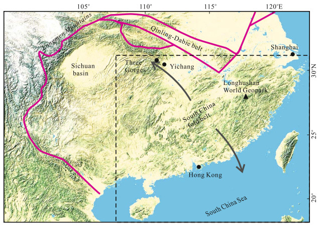
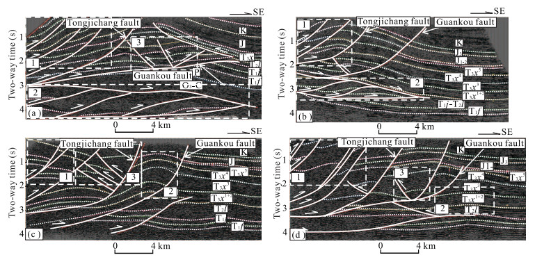
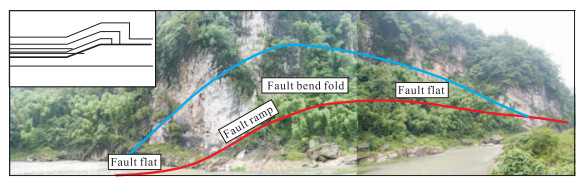
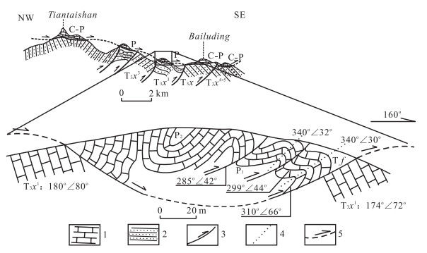
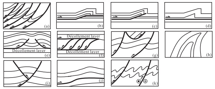
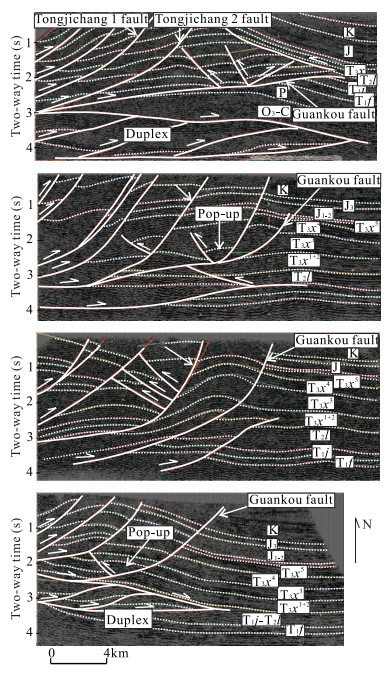
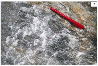
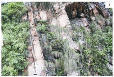
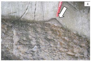
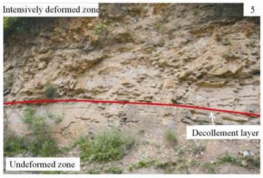
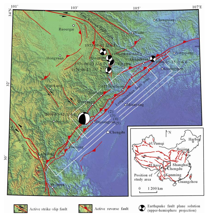
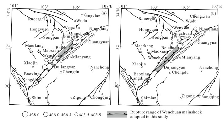
Through field geological investigation and seismic interpretation of the Longmen (龙门) Mountain thrust belt, we summarized the following structural styles: thrust belt, fault-related fold (fault bend fold, fault propagation fold, and fault decollement fold), pop-up, triangle zone, duplex, superimposed fold, ductile deformation structures, reverse thrust fault, klippe, decollement structure, etc.. These structural styles have evident distribution characteristics; they had zonation and segmentation in plane. The zonation presents as the thrust nappe tectonic zone to the west of Tongjichang (通济场) fault, fault-related folds between Tongjichang fault and Guankou (关口) fault, and low and mild folds to the east of Guankou fault. The segmentation is evidenced as the scale of reverse thrust faults was minor between Tongjichang No. 1 fault and Tongjichang No. 2 fault. The distance between these two faults became long in the Dayuanbao (大园包) structure, and there developed typical fault propagation fold and pop-up between these two faults. Furthermore, the structures had stratification in profile. The salt layer of T2l provided good conditions for the formation and development of large listric thrust faults; the thrust fault slipped in the salt layer and formed decollement structures and fault-related fold. At the same time, there formed duplex and reverse thrust faults between the two decollement layers.
Static stress triggering effects related with Ms8.0 Wenchuan earthquake
Hang ZHU, Xueze WEN
2010, 21(1): 32-41. doi: 10.1007/s12583-010-0001-8
Abstract:
In this article,firstly,we calculated and analyzed the patterns of Coulomb stress changes induced by a sequence of strong earthquakes that occurred in Songpan (松潘),Sichuan (四川) Province in 1973 and 1976, and discovered that the Ms8.0 Wenchuan (6C76;川) earthquake of 2008 was epicentered in a relevant Coulomb stress triggering zone. This suggests that the Coulomb stress on the middle and southern segments of the Longmenshan (龙门山) fault zone increased after the Songpan sequence of strong earthquakes,and the stress increment might cause the 2008 Wenchuan earthquake having already occurred somewhat ahead of time. Further,we calculated and analyzed Coulomb stress changes coinduced by both the Songpan sequence and the Ms8.0 Wenchuan mainshock. The result shows that the Ms6.4 Qingchuan (青川) earthquake of May 25,2008 on the northeastern segment of the Longmenshan fault zone was triggered by the Wenchuan mainshock,and that the southwestern segment of the fault zone is also in the stress triggering zone. Besides,the Maoxian (茂县)-Wenchuan fault (i.e.,the back-range fault of the Longmenshan fault zone),which extends parallel to the seismogenic fault of the Wenchuan earthquake,is in a shadow zone of the Coulomb stress changes,and therefore,its potential hazard for producing a strong or large earthquake in the near future could be reduced relatively.
Biogenic sediments and their paleoceanographic implication in West Pacific Warm Pool during the Pleistocene
Rujian WANG, Wenshen XIAO
2010, 21(1): 42-54. doi: 10.1007/s12583-010-0002-7
Abstract:
Primary productivity has played an important role in the global carbon cycle during the Quaternary. The average Corg/N ratio was 7.0 from the core MD97-2140 in the West Pacific Warm Pool (WPWP) over the last 1 755 ka, which indicates a main contribution of marine organic carbon to the organic matter in the sediments. Large fluctuations in mass accumulation rates (MARs) of biogenics and lithogenics from this core since the marine isotope stage (MIS) 6 reflected the moderate variability in oceanographic condition, while little fluctuations in MAR-biogenics and -lithogenics from the MIS 59 to MIS 7 implied the relatively stable and uniform oceanographic condition, although the sea surface temperatures (SSTs) probably fluctuated by ca. 5 ℃. MAR-organic since the MIS 6 increased evidently during the glacial periods, which ascribed to terrestrial inputs, including lithogenic matter and dissolved nutrient, which also contribute to stimulating primary productivity. The results compared among the four cores in the WPWP since the MIS 9 indicate that in the western sector with the shallow thermocline, high primary productivity during the glacial periods was controlled by wind-induced surface water mixing, upwelling, and terrestrial inputs, while in the central and eastern sectors, the little different medium to low productivity might have been made by more intense upwelling driven by strong winds because the thicker warm surface water pool and the deeper thermocline prevented nutrient-bearing water from upwelling to upper water column even during the glacial times.
Activity and formation of sand waves on northern South China Sea shelf
Xiwu LUAN, Xuechao PENG, Yingmin WANG, Yan QIU
2010, 21(1): 55-70. doi: 10.1007/s12583-010-0005-4
Abstract:
Sand waves on the northern South China Sea shelf had been considered as stable relict bed form. For the industry use of sea bed between stations LF13-2 and LF13-1, a new round of explorations were conducted. The newly obtained data show that both spacings and amplitudes of sand waves are all systematically changing with water depth. Repeated observations since 2003 to 2004 showed that the sea bed is currently active. Due to strong erosion of surface sediment since Dongsha (东沙) uplifting, there are almost no modern sediments on the shelf of Dongsha area. Sand materials in the study area mainly originate from the erosion of the bed sediment formation. The water depth increment revealed by repeated echo sounder data is mainly due to erosion. Bottom currents are quite complex in the area of Dongsha underwater plateaus. At site 9MKII, the southward ebb current is stronger than the northward flood current, while at site AEM-HR, the WNW-ward flood current is slightly stronger than the ESE-ward ebb current. At site 9MKII, the maximum bottom current speed is 48 cm/s, and 22% of the observed bottom current speeds are larger than 20 cm/s, which meet the minimum bottom current speed required for the creation of sand wave. This article points out that present-day oceanographic condition couples well with the sand-wave morphologies, and that the sand waves are to a great extent in equilibrium with the ongoing present-day oceanographic bottom current condition and active.
Tectonic Evolution and Hydrocarbon Potential in Northern Area of the South Yellow Sea
Yongjian Yao, Chunfeng Chen, Zhiqiang Feng, Shiying Zhang, Tianyao Hao, Rongsheng Wan
2010, 21(1): 71-82. doi: 10.1007/s12583-010-0006-3
Abstract:
The northern area of the South Yellow Sea, located in the offshore region of China, resulted from the continental-continental collision orogeny during the Mesozoic and can be divided into four stages in terms of tectonic evolution: (1) pre-orogenic passive continental margin stage (Z-T2); (2) foreland basin stage corresponding with the late phase of the Sulu (苏鲁) orogeny (J3-K); (3) post-orogenic intracontinental rifted basin stage (K2 t-E); and (4) regional subsidence and coverage stage (N-Q). Based on detailed investigation and study of the intracontinental rifted basin, hydrocarbon source rocks of Late Cretaceous Taizhou (泰州) Formation distributed well in the basin, and four reservoir-cap combinations as well as numerous trap structures were found. As a result, the geological conditions would be excellent for reservoir formation in the basin, and the oil resource amount is estimated at about 20×108 t, which makes the basin a major target for hydrocarbon exploration in the South Yellow Sea.
Complex Petroleum Migration and Accumulation in Central Region of Southern Junggar Basin, Northwest China
Jian Cao, Xulong Wang, Dongtao Wei, Ping'an Sun, Wenxuan Hu, Dong Jia, Yingcheng Zhao
2010, 21(1): 83-93. doi: 10.1007/s12583-010-0004-5
Abstract:
The central region of the southern Junggar basin (Northwest China) is a key exploration target in this petroliferous basin. As there are four sets of potential source rocks (e.g., Permian, Jurassic, Cretaceous and Paleogene sequences), petroleum migration and accumulation are likely complex. This study represents an attempt to understand this complexity in order to provide fundamental information for future regional petroleum exploration and geological studies. Based on petroleum geology and geochemistry, it is implied that there are mainly three types of hydrocarbons, including Cretaceous- and Paleogene-sourced oils (with the former being dominant) and Jurassic-sourced gas. The petroleum migration and accumulation mainly cover three stages. The first stage is the late period of the Early Pleistocene, in which the Cretaceous-sourced oils migrate and accumulate. Then, in the second stage (from the late period of the Middle Pleistocene to the early period of the Late Pleistocene), the Cretaceous-sourced oils, together with the Paleogene-sourced oils, participate in the migration and accumulation. At last, in the end of the Late Pleistocene, large quantities of oils remigrate and accumulate, with gas (especially Jurassic-sourced gas) migrating along faults to accumulate. Thus, petroleum charge events in the area are complex, reflecting the control of complex tectonic evolution on petroleum migration and accumulation.
Complex Petroleum Migration and Accumulation in Central Region of Southern Junggar Basin, Northwest China
Yanming Zhu, Shangbin Chen, Xiaodong Lan, Meng Wang, Junhua Fang
2010, 21(1): 94-103. doi: 10.1007/s12583-010-0007-2
Abstract:
The Dongpu (东濮) depression is a Mesozoic subsidence and Cenozoic fault basin developed within the North China craton. Since the deposition of Permo-Carboniferous hydrocarbon source rock, the depression has undergone many tectonic disturbances and uplifts. The source rocks have undergone nonuniform uplift, deformation, deep burying, and magmatism, and those led to an interrupted or stepwise evolution of the hydrocarbon source rocks in Qinggu (庆古)-2 well. We have investigated the history of burying, heating, and hydrocarbon generation of the Permo-Carboniferous hydrocarbon source rocks not just on the basis of tectonic disturbance and deep burying, but also with new studies in apatite fission track analysis, fluid inclusion measurements, and the application of the numerical simulation of EASY%Ro. The heating temperature of the source rocks pulsated upward from Indosinian to Himalayan stages and reached a maximum during early Himalayan. This led to the stepwise increases of organic maturation and multiple stages of hydrocarbon generation. This study delineated the tectonic stages, maturity evolved ranges, and the intensity of hydrocarbon generation of Permo-Carboniferous source rocks in Qinggu-2 well. The hydrocarbon generation mainly occurred during Indosinian and early Himalayan. The early Himalayan stage hydrocarbon generation is the larger one, but the Dongying (东营) movement, which happened at the end of early Himalayan, may destroy the trapped oil and gas. Thereby, future exploration will need to pay more attention to the Dongying movement effect in Qinggu-2 well area, and it may get new breakthrough in Permo-Carboniferous oil and gas.
Characteristics of Landslides Induced by the Great Wenchuan Earthquake
Huiming Tang, Hongbiao Jia, Xinli Hu, Dewei Li, Chengren Xiong
2010, 21(1): 104-113. doi: 10.1007/s12583-010-0008-1
Abstract:
The great Wenchuan (汶川) earthquake induced a large quantity of landslides. They are widely distributed and caused tremendous damages. The sliding mechanism and characteristics of these earthquake-induced landslides are different from those of conventional gravity landslides. Their occurrences are apparently controlled by the powerful earthquake, and they are characterized by high potential energy sliding and ejection sliding. In this article, the earthquake-induced landslides are classified, the characteristics of the sliding and destruction of these landslides are described, and the relationship between the earthquake and the landslides is analyzed. The Donghekou (东河口) landslide is used as an example to characterize fast-moving long-distance earthquake-induced ejection slippage and landslide. This research suggests that many phenomena and issues related to earthquake-induced landslide are beyond current recognition and knowledge, and new methodologies should be adopted to consider the effect of the earthquake as the paramount factor in the development of landslides. Furthermore, the study of fast-moving long-distance earthquake-induced landslides can also shed light on the formation of old and ancient landslides.
Transformations between Aeromagnetic Gradients in Frequency Domain
Haixia Li, Shizhe Xu, Hailong Yu, Wei Wei, Jiangqi Fang
2010, 21(1): 114-122. doi: 10.1007/s12583-010-0003-6
Abstract:
Aeromagnetic gradients are often used to enhance details or add new insights for interpretation. The gradients may be measured or derived from the total field or from transformation between horizontal and vertical gradients. At present, vertical, horizontal, and triaxial aeromagnetic gradiometers are in operation throughout the world, while the first two are used more widely. Transformations between horizontal and vertical gradients are needed for acquiring three gradient components or for checking the validity of measured gradients. Transformation of potential field by fast Fourier transform technique in frequency domain is popularly used; however, when applied to transforming between gradients, there is a problem that needs resolving. Because those expressions of transform operators are undefined when u or v is equal to zero or u and v are simultaneously equal to zero (u is the frequency in x-direction, and v is the frequency in y-direction), the operators cannot be sampled at these frequencies. Consequently, the transformation cannot be implemented by fast Fourier transform technique directly. In this article, shift sampling theory is employed for resolving this problem. Model test results show that the technique has good accuracy, and the real case of transformation indicates that the computed results agree better with the measured gradients; it demonstrates not only the effectiveness of method but also the reliability of the measured gradients.