Advanced Search

Indexed by SCI、CA、РЖ、PA、CSA、ZR、etc .

2014 Vol. 25, No. 6

Display Method:
Research
High-Pressure Experimental Studies on Geo-Liquids Using Synchrotron Radiation at the Advanced Photon Source
Yanbin Wang, Guoyin Shen
2014, 25(6): 939-958. doi: 10.1007/s12583-014-0504-9
Abstract:
We review recent progress in studying silicate, carbonate, and metallic liquids of geological and geophysical importance at high pressure and temperature, using the large-volume high-pressure devices at the third-generation synchrotron facility of the Advanced Photon Source, Argonne National Laboratory. These integrated high-pressure facilities now offer a unique combination of experimental techniques that allow researchers to investigate structure, density, elasticity, viscosity, and interfacial tension of geo-liquids under high pressure, in a coordinated and systematic fashion. Experimental techniques are described, along with scientific highlights. Future developments are also discussed.
Evolution of an Eocene–Oligocene Saline Lake Depositional System and Its Controlling Factors, Jianghan Basin, China
Chunju Huang, Linda Hinnov
2014, 25(6): 959-976. doi: 10.1007/s12583-014-0499-2
Abstract:
The Upper Eocene-Lower Oligocene Qianjiang Formation of the Jianghan Basin in central China consists of a 4 700-m-thick lacustrine succession, containing 1 800 m of halite deposits. The maximum thickness of the formation is 4 700 m, and includes 1 800 m of halite. We have identified eight third-order depositional sequences based on pinch-out and onlap stratigraphic patterns in 2-D and 3-D seismic data and well logs. The basin evolved from a deep to shallow under-filled lake during the Eocene-Oligocene interval. The main rock types are dark mudstones, halite, and siltstone/sandstone in the depocenter, and alternating mudstone and gypsum in shallower areas. The vertical succession indicates a strong sedimentary cyclicity. Depositional facies indicate the presence of two lake system types. Halite developed in a saline lake system, whereas clastic sediments were deposited in freshwater lake systems. The alternating sediment types indicate that the basin cycled repeatedly between saline and freshwater lake systems. This cyclicity was caused by availability of accommodation space that was controlled by a combination of climate change, tectonic subsidence and sediment supply; notably, the highest frequency cycles occurred at Milankovitch timescales controlled by the Earth's orbital variations. The cyclic halite plays an important role in generating and preserving oil in the Qianjiang Formation of the Qianjiang depression.
Body Waves Revealed by Spatial Stacking on Long-Term Cross-Correlation of Ambient Noise
Kai Wang, Yinhe Luo, Kaifeng Zhao, Limeng Zhang
2014, 25(6): 977-984. doi: 10.1007/s12583-014-0495-6
Abstract:
Theoretical and experimental studies indicate that complete Green's Function can be retrieved from cross-correlation in a diffuse field. High SNR (signal-to-noise ratio) surface waves have been extracted from cross-correlations of long-duration ambient noise across the globe. Body waves, not extracted in most of ambient noise studies, are thought to be more difficult to retrieve from regular ambient noise data processing. By stacking cross-correlations of ambient noise in 50 km inter-station distance bins in China, western United States and Europe, we observed coherent 20-100 s core phases (ScS, PKIKPPKIKP, PcPPKPPKP) and crustal-mantle phases (Pn, P, PL, Sn, S, SPL, SnSn, SS, SSPL) at distances ranging from 0 to 4 000 km. Our results show that these crustal-mantle phases show diverse characteristics due to different substructure and sources of body waves beneath different regions while the core phases are relatively robust and can be retrieved as long as stations are available. Further analysis indicates that the SNR of these body-wave phases depends on a compromise between stacking fold in spatial domain and the coherence of pre-stacked cross-correlations. Spatially stacked cross-correlations of seismic noise can provide new virtual seismograms for paths that complement earthquake data and that contain valuable information on the structure of the Earth. The extracted crustal-mantle phases can be used to study lithospheric heterogeneities and the robust core phases are significantly useful to study the deep structure of the Earth, such as detecting fine heterogeneities of the core-mantle boundary and constraining differential rotation of the inner core.
3D Seismic Attributes for Structural Analysis in Compressional Context: A Case Study from Western Sichuan Basin
Bo Xu, Ancheng Xiao, Lei Wu, Liguang Mao, Youpu Dong, Lijun Zhou
2014, 25(6): 985-990. doi: 10.1007/s12583-014-0497-4
Abstract:
Compressional region usually forms complex thrust faults system, which is difficult to identify using traditional migration profiles. The successful application of three-dimensional (3D) seismic attributes analysis greatly reduces the difficulty, and improves the accuracy and efficiency of seismic interpretation and structural analysis. In this paper, we took Qiongxi area in the compressional region of western Sichuan as an example, using two 3D seismic attributes, coherence and instantaneous phase, to identify fault assemblages and variations both vertically and laterally. The results show that the study area mainly consists of NS-, NE- and NEE-trending faults. The NS-trending faults are the largest and have a component of sinistral slip controlling the formation of NEE-trending faults, while the NE-trending faults are intermediate in scale, formed earlier and were cut by the NS-trending faults. Our results demonstrate that using seismic attributes for structural analysis have the following advantages: (1) more details of major fault zones, (2) highlighting minor faults which are hardly traced in seismic migration cube, and (3) easier acquisition of accurate fault systems. The application of seismic attributes provides a new idea for deciphering fine and complicated structures, and will significantly contribute to the development of objective and precise geological interpretation in the future.
Statistical Verification of Hydraulic Units in a Heterogeneous Reservoir of the Liaohe Oilfield
Wei Zhou, Shuxian Liang, Desheng Ma, Zhonghua Tang
2014, 25(6): 991-1002. doi: 10.1007/s12583-001-0434-1
Abstract:
The Liaohe Oil Field has passed peak production and correct discrimination of hydraulic units (HU) has vital significance for forecasting remaining oil distribution in a petroleum reservoir, enhancing the recovery ratio and adjusting development plans. A unified multi-parameter cluster analysis and fuzzy quality synthetic evaluations have been used for the identification of reservoir hydraulic units. This paper analyzes three predictions within Block Shen-95: intersection of multiple well-logs, independent mulitple well-logs and mutually exclusive multiple well-logs. HU has been delineated to conveniently compute permeability and serve as the basis of a structural model for enhanced simulation study. HU has been defined by the flow zone indicator concept using a modified Kozeny-Carmen equation. The Bayesian method was used to predict HU at uncored wells by constructing a probability database and then integrating established HU and well-log responses at cored wells. HU has then been inferred from the database using well-log responses. Estimated permeability from predicted HU gave an overall improved permeability match when compared with traditional statistical methods. The method proved most favourable when using mutually exclusive multiple well-logs, most significant by integrating reservoir performance with HU distribution and indicating that reasonable prediction had been obtained at uncored wells using this mutually exclusive approach. The distribution pattern was revealed by interwell HU correlation using modified depositional cycles as a framework, an integration step that qualitatively examines prediction accuracy. Detailed analysis has been carried out to determine and verify the characteristics of each kind of flow unit, providing a detailed geological basis for control of the oil field.
Stratigraphic Framework and Microfacies of the Triassic Lower Karamay Formation in Districts Ⅰ, Ⅲ, NW Junggar, China
Miao He, Zhenkui Jin, Tingdong Li, Xiujuan Guo, Ting Yang
2014, 25(6): 1003-1017. doi: 10.1007/s12583-014-0496-5
Abstract:
The Triassic Lower Karamay Formation (T2k1) is one of the main oil-bearing stratigraphic units in the northwestern margin of Junggar Basin (NW Junggar), China. Based on an integrated investigation of outcrops, well logs and seismic data of NW Junggar, the Lower Karamay Formation is subdivided into 2 sets, 6 beds and 13 layers. Also, it is considered that the alluvial fan, the braided river, the meandering river and the shore-shallow lacustrine were developed during the early period of Middle Triassic in Karamay districts Ⅰ, Ⅲ. The Lower Karamay Formation deposits the following 9 sedimentary subfacies: the lower fan, the middle fan, the upper fan, the braided channel, the overflow bank, the river flood of braided river, the meandering channel, the river flood of meandering river, the shore-shallow lacustrine. Seventeen microfacies such as the braided stream channel, the alluvial sand floodplain, the alluvial glutenite floodplain, the water channel, the channel bar etc. have been identified in subfacies as well. The thickness of strata is firstly up-thinning and then thickening upward to the top, it is a process from large-scale lacustrine transgression to partly lacustrine regression. Furthermore, the microfacies planar distributing law proves that the remaining oil may enrich along the margin of microfacies because of the planar microfacies changes. Therefore, this research is beneficial for searching remaining oil in NW Junggar and providing information to the project "The Secondary Exploration" of PetroChina.
Basin Geomorphology and Drainage Morphometry Parameters Used as Indicators for Groundwater Prospect: Insight from Geographical Information System (GIS) Technique
Kumar Avinash, B Deepika, K S Jayappa
2014, 25(6): 1018-1032. doi: 10.1007/s12583-014-0505-8
Abstract:
Influence of structural and lithological controls of various drainage patterns and their stream orientations (for 2nd, 3rd and 4th order steams) were identified to evaluate the direction and controlling factors of drainage network. To investigate the prospect of groundwater, hydrogeomorphological features of river basin viz. Mulki-Pavanje were identified and mapped. To evaluate the characteristics of the basin, different morphometric parameters (linear, areal and relief) were computed in sub-basin wise (SB-Ⅰ to -Ⅶ). The linear parameters suggest drainage network is controlled by geomorphology. The form factor (Ff), elongation ratio (Re) and circularity ratio (Rc) suggest that the basin is in an elongated shape. The drainage density (Dd) indicates resistant/permeable strata under medium-dense vegetation with moderate relief. The areal parameters of the sub-basins (except SBI and Ⅲ) indicates moderate ground-slopes associated with moderately permeable rocks, which promote moderate run-off and infiltration. Drainage texture (T) of the whole basin indicates coarse texture while the SB-Ⅰ, and Ⅲ showing an intermediate texture. The relief parameters namely ruggedness number (Rn ) infers low basin relief and poor drainage density. To identify the most deficit/surplus zones of groundwater suitable weightages were assigned to the hydrogeomorphological units and morphometric parameters. The study reveal that the basin manifest that SB-Ⅲ shall be most deficit zone of groundwater, whereas SB-Ⅶ, Ⅵ and Ⅴ are found to show increase in groundwater potentiality. Groundwater prospect area in this basin is estimated to be 7% area under poor, 44% area under moderate and 49% area under good to excellent. This paper demonstrated the potential application of geographical information system (GIS) techniques to evaluate the groundwater prospect in absence of traditional groundwater monitoring data.
Study on the Estimation of Groundwater Withdrawals Based on Groundwater Flow Modeling and Its Application in the North China Plain
Jingli Shao, Yali Cui, Qichen Hao, Zhong Han, Tangpei Cheng
2014, 25(6): 1033-1042. doi: 10.1007/s12583-014-0493-8
Abstract:
The amount of water withdrawn by wells is one of the quantitative variables that can be applied to estimate groundwater resources and further evaluate the human influence on groundwater systems. The accuracy for the calculation of the amount of water withdrawal significantly influences the regional groundwater resource evaluation and management. However, the decentralized groundwater pumping, inefficient management, measurement errors and uncertainties have resulted in considerable errors in the groundwater withdrawal estimation. In this study, to improve the estimation of the groundwater withdrawal, an innovative approach was proposed using an inversion method based on a regional groundwater flow numerical model, and this method was then applied in the North China Plain. The principle of the method was matching the simulated water levels with the observation ones by adjusting the amount of groundwater withdrawal. In addition, uncertainty analysis of hydraulic conductivity and specific yield for the estimation of the groundwater withdrawal was conducted. By using the proposed inversion method, the estimated annual average groundwater withdrawal was approximately 24.92×10⁹ m3 in the North China Plain from 2002 to 2008. The inversion method also significantly improved the simulation results for both hydrograph and the flow field. Results of the uncertainty analysis showed that the hydraulic conductivity was more sensitive to the inversion results than the specific yield.
Changes of Vertical Groundwater Recharge with Increase in Thickness of Vadose Zone Simulated by One-Dimensional Variably Saturated Flow Model
Siyuan Huo, Menggui Jin, Xing Liang, Dan Lin
2014, 25(6): 1043-1050. doi: 10.1007/s12583-014-0486-7
Abstract:
The thickness of vadose zone plays a critical role in vertical groundwater recharge. The decline of water table since the past decades due to long-term groundwater over-exploitation has resulted in deep vadose zone in North China Plain. One-dimensional variably saturated flow models were established by Hydrus-1D software and simulations were run under steady and continuous declining water table respectively to estimate the impact of increase in thickness of vadose zone on recharge process, quantity and recharge time. Luancheng area was selected to estimate recharge quantity considering steady and continuous declining water table. The simulation results show that the increase in thickness of vadose zone delays recharge process to water table. The recharge quantity decreases first and then remains stable with the decline of water table. Under the condition of declining water table, the evaluation of recharge by the flux at water table overestimates the recharge quantity. The average annual recharge rate of Luancheng area is 134 mm/a.
Evolution Characteristics and Influence Factors of Deep Groundwater Depression Cone in North China Plain, China––A Case Study in Cangzhou Region
Yasong Li, Fawang Zhang, Zhantao Han, Ping Wang, Honghan Chen, Zhaoji Zhang
2014, 25(6): 1051-1058. doi: 10.1007/s12583-014-0488-5
Abstract:
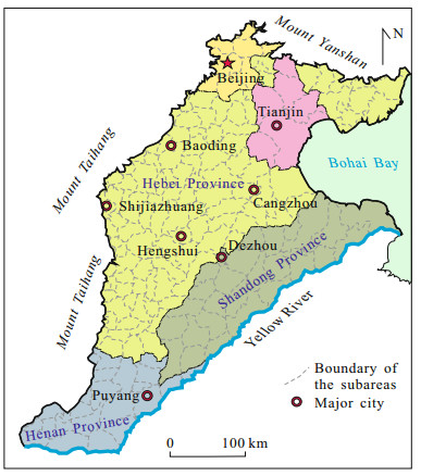
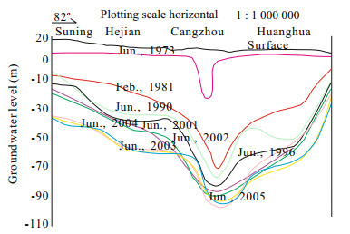
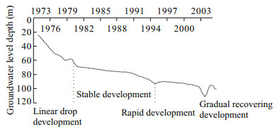
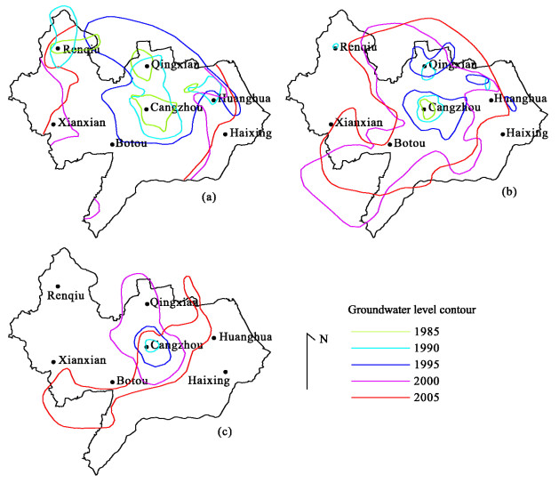
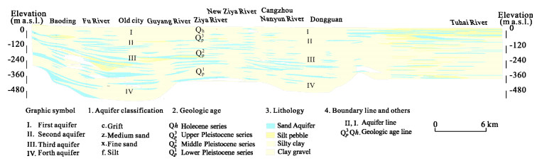
The North China Plain (NCP) is one of the global hotspots of groundwater depletion, groundwater is almost the only source of water for agricultural, industrial and drinking water in this region. After long-term's over-exploitation of deep groundwater, there appeared several deep groundwater depression cones, such as Cangzhou cone, Dezhou cone, Hengshui cone, Tianjin cone, etc., in which the Cangzhou cone is one of the typical cones for its special geography and hydrogeology conditions. In this study, the authors intended to analyze the evolution characteristics and influence factors of deep groundwater depression cone in Cangzhou region, especially the No. III aquifer depression cone, which is the main exploitation zone in this region. Analysis of the evolution of the groundwater depression cone of the No. III aquifer group in Cangzhou region showed that this process can be divided into four stages, namely, development, stable development, rapid expansion, and gradual recovery. The shape and evolution characteristics of the depression cone at different stages are described by analyzing the evolution of the −30, −40, and −50 contours of the groundwater table, for example the closed area of water table contour of −50 m has been enlarged from 95 km2 in 1985 to 6 528.5 km2 in 2005. The dominant factors that affect the evolution characteristics at different stages are proposed. The results showed that relatively long dry periods with less precipitation, special geological and hydrogeological conditions, and sharply increased water consumption for industrial and agricultural development are the main factors that cause the formation of deep groundwater depression cones. Meanwhile, an environmental response against groundwater exploitation is presented, and rational solutions are suggested to avert water crisis.
Parallel Simulation of Groundwater Flow in the North China Plain
Tangpei Cheng, Jingli Shao, Yali Cui, Zeyao Mo, Zhong Han, Ling Li
2014, 25(6): 1059-1066. doi: 10.1007/s12583-014-0485-8
Abstract:
Numerical modeling is of crucial importance in understanding the behavior of regional groundwater system. However, the demand on modeling capability is intensive when performing high-resolution simulation over long time span. This paper presents the application of a parallel program to speed up the detailed modeling of the groundwater flow system in the North China Plain. The parallel program is implemented by rebuilding the well-known MODFLOW program on our parallel-computing framework, which is achieved by designing patch-based parallel data structures and algorithms but maintaining the compute flow and functionalities of MODFLOW. The detailed model with more than one million grids and a decade of time has been solved. The parallel simulation results were examined against the field observed data and these two data are generally in good agreement. For the comparison on solution time, the parallel program running on 32 cores is 6 times faster than the fastest MICCG-based MODFLOW program and 11 times faster than the GMG-based MODFLOW program. Therefore, remarkable computational time can be saved when using the parallel program, which facilitates the rapid modeling and prediction of the groundwater flow system in the North China Plain.
Hydrochemical Characteristics and the Suitability of Groundwater in the Coastal Region of Tangshan, China
Fengshan Ma, Aihua Wei, Qinghai Deng, Haijun Zhao
2014, 25(6): 1067-1075. doi: 10.1007/s12583-014-0492-9
Abstract:
Through collecting groundwater samples from the coastal region of Tangshan, China, the hydrochemical processes that affect the chemical composition of groundwater and the quality of resources were analyzed. Chemical constituents, factor analysis, and a graphic method were employed in this research. The results show that human activities obviously affect fresh groundwater. The deep groundwater distributed in the southern part of the region is severely affected by salinization, and the shallow groundwater in the north is also beginning to show the same deterioration. The chemical concentrations of the deep groundwater depend largely upon the water-rock interaction, the mixing of saline water and the ion exchange processes. With the exception of sample C-33, all the groundwater samples in the study area are suitable for drinking. Tests show that roughly half of the deep groundwater samples have at least one water quality index indicating that it is chemically doubtful or unsuitable for irrigation. Therefore, it is concluded that deep groundwater is becoming an unacceptable resource to irrigate areas located near the coastline because the groundwater quality in the study area is exhibiting signs of degradation. This study's findings contribute to a better understanding of groundwater resources in order to support regional management and protection.
Experimental Evidence for Hyperfiltration of Saline Water through Compacted Clay Aquitard in the Hebei Plain
Ying Wang, Zongyu Chen, Baoqian Duan, Jingli Shao
2014, 25(6): 1076-1082. doi: 10.1007/s12583-014-0490-y
Abstract:
It becomes an increasing concern that groundwater quality in exploited deep confined aquifer may deteriorate due to brackish water leakage from its overlying saline aquifer in Hebei Plain. However, the monitoring data show that the TDS does not significantly change in the exploited aquifer. Some physics or chemistry processes must have taken place in aquitards during brackish leakage. The semi-permeable membrane function of clay aquitard during the process of hyperfiltration (reverse osmosis) should be one of the most important processes. To confirm and test this hyperfiltration mechanism, a series of experiments were performed in which NaCl solutions were hydraulically forced through different clay sampled from aquitard. The solution 7 g/L in NaCl was forced through at 20 ℃ by a fluid pressure of 0.5 kN. The results show that hyperfiltration indeed happens in caly aquitard. Semi-permeability is quantified by the reflection coefficient σ. The mean rejection coefficients (σ) for clay samples #1, #2 and #3 were estimated to be 0.063, 0.164 and 0.040, respectively. This behavior of clay was well explained with the theory of the diffuse double layer. The hyperfiltration effect is to the great extent responsible for the chemical process in the aquitard.