Advanced Search

Indexed by SCI、CA、РЖ、PA、CSA、ZR、etc .

2002 Vol. 13, No. 1

Display Method:
 
Triassic Collisional Structures and Post-Collisional Deformation of Bixiling UHP Rock Stack: Insights for Tectonic Evolution of UHP Metamorphic Belt in Dabie Massif,Central China
Shutian Suo, Zengqiu Zhong, Hanwen Zhou, Zhendong You
2002, 13(1): 1-13.
Abstract:

Detailed three-dimensional structural studies indicate that the Bixiling area, Dabie massif, central China shows the deepest exposed levels of the orogenic wedge formed during the Triassic Yangtze-Sino-Korean continental collision, New 1 : 10000 scale structural mapping, combined with detailed petrological analysis in this area, has enabled us to accurately distinguish structures related to the Triassic continental collision from those related to post-collisional deformation in the ultrahigh pressure(UHP)metamorphic unit.The collisional or compressional structures include the massive eclogite with a weak foliation, foliated eclogite or UHP ductile shear zones, as well as upper amphibolite facies shear zones, whereas the post-collisional deformation is characterized by a regionally, flat-lying foliation containing stretching lineations and common reclined folds. The former is present exclusively in the eclogite lenses and their margins, representing orogenic thickening or syn-collisional events, while the latter was best occurred on varilable scales under amphibolite facies conditions, showing sub-verticai, extreme shortening and ductile thinning of the metamorphic rock stack, The eclogite facies tectonites that have a marked fabric discordance to the penetrative amphibolife facies extension flow fabric are common.It is emphasized that an extensional tectonic setting following the collision-orogenic thickening stage was, at least partly, responsible for exhumation of the UHP metamorphic rocks in the Dabie massif. A new tectonlc evolution model is proposed for the UHP metamorphic belt on the scale of the Dabie massif.The Bixiling area thus provides a window, from which the dynamic processes concerning the formation and exhumation of the UHP rocks can be observed.Regional studies in the Dabie Mountains have confirmed this interpretation.

Intraplate Deformation of Asia Derived from ITRF2000 Velocity Field
Shuanggen Jin, wenyao Zhu
2002, 13(1): 14-19.
Abstract:

The definition of an 'intraplate fixed' frame remains a significant error source for crustal motion studies at a few millimeters per year level. An appropriate implementation of such a frame is very important to avoid biased velocities and to confirm a valid geophysical interpretation. Here,we establish the newest global plate motion model of ITRF2000VEL and research the definition of an Asian-fixed frame in Asia using the ITRF2000 velocity field. By X2 and F ratio tests,we find a subset site in Asia that satisfies a rigid cap rotation with residual velocities & lt; 0. 95 mm/a and provide a stable Asia reference frame (SARF). In this reference frame,we find residual velocities at Asiatic ITRF2000 sites that are consistent with known active tectonic feature. An important result of this study is the identification of internal deformation of the order of 1-2 mm/a in an area usually interpreted as 'stable' Asia. These results should be further checked as newer,denser and more accurate space geodetic data sets with longer observation time span,which become available for Asia.

Effective Elastic Thickness of Southeast Part of Arctic Ocean-Eurasia Continent-Pacific Ocean Geoscience Transect
Bingqiang Yuan, Yvette H Poudjom Djomani, Ping Wang, Xuecheng Yuan, Yu Zuo
2002, 13(1): 20-25.
Abstract:

The effective lithospheric elastic thickness of the continent is an important parameter for examination of the large-scale structure and analyses of the mechanism of isostatic compensation within the plate, and a parameter standing for the strength of the lithosphere. The Te values along Quanzhou-Heishui, the southeast section of the Arctic Ocean-Eurasian Continent-Pacific Ocean geoscience transect, are estimated by using the coherence technique developed by Forsyth.Studies of the feature of the coherence between gravity and topography suggest that at short wavelengths(6.6-100 km) for each data box that is used to estimate Te, the plate is strong enough to support topographic loads and gravity and topography are uncorrelated.At long wavelengths where the plate is deflected by surface and subsurface loads are compensated by the flexure model.Sichuan land-stone with low heat-flow values has high Te values whereas in Ninghua, Datian, land-stone with high heat-flow values has low Te, values, which reflects a correlation, low heat-flow values corresponding to high Te values and high heat-flow values corresponding to low Te values. Te values can be divided into two sections: northwest high section and southeast low section.There is roughly a positive correlation between crustal thickness and effective elastic thickness of the lithosphere.

Study on Folds of Equal Thickness Multi-layer Sandwiched in Different Thickness Media
Bailong Ye, Ainan Yu, Jiantao Ouyang
2002, 13(1): 26-29.
Abstract:

The theoretical mudel and non-homogeneous differential equation of equal thickness multi-layer folds sandwiched in different thickness and sallfle charactar media are established by elastic and plastic mechania. The special answer of the non-homogeneous differential equation and the common answer of the homogeneous differential equation are deduced by applying logistic equation and special function, and the dominant wavelength theory of equal thickness multi-layer folds sandwlched in different thickness and same character media. in addition. the experimental folding in hoth elastic and sticky materials proves the dominant wavelength theory.

Discovery of Enclaves from Cenozoic Pulu Volcanic Rocks in West Kunlun Mountains and Its Geological Implications
Zhaochong Zhang, Xuchang Xiao, Jan Wang, Yong Wang
2002, 13(1): 30-34.
Abstract:

In this paper, we present the occurrence and mineral components of the enclaves firstly dis-covered in the Cenozoic Pulu volcanic rocks in west Kunlun Mountains, and propose that the enclave is accumulated by fractional crystallization within high-level magma chamber.In addition, the chemical compostions of its primary magma are calculated.The calculated compositions are similar to those of the Kangxiwa volcanic rocks that belong to the same volcanic belt in the Pulu volcanic region, suggesting their origin from the same source region.However, the temperatures and oxygen fugacity of magmas at high-level magma chamber decreased along with fractional crystallization.

Growth of Emerald Crystals by Evaporation of Na2O-MoO3 Flux
Shuji Oishi, Hirafumi Yamamoto, Takaomi Suzuki
2002, 13(1): 35-39.
Abstract:

Well-formed crystals of emerald, Be3Al2Si6O18 : Cr, were easily grown from an Na2O-MoO3 flux by an isothermal technique. The crystal growth was conducted by heating a mixture of solute and flux at 1 100 ℃ for 24 h. The evaporation loss of flux depended on the amount of Na2O added to MoO3. Emerald crystals of lengths up to 2.1 mm and widths of 1.4 mm were grown. The crystal sizes were dependent on the evaporation loss of the flux. The obtained crystals were transparent and exhibited the typical emerald~green color. The form of the emerald crystals was a twelve sided prism bounded by well~developed faces. The aspect ratios were in the region of 1.4 to 2.3. The density was (2.64±0.02) g/cm3. The IR absorption bands were in good agreement with the literature data.

Study on Paleoenvironment since Late Glacial Epoch in Lanzhou Area, China
Guifang Yang, Hongfu Yin, Chang'an Li
2002, 13(1): 40-43.
Abstract:

The Hongzuisi Section Lanzho aren is used to infer the pateocllmate since the late glaclal epoch. Through combined analysis of organic carbon isotope and CaCO3 content, paleornvlronment evolution of Hongzuisi Section since the late glacial epoch is discussed. Thexe were changes in both drymoist and warm-cold. Especially the dlmate changes can be compared with synchronous sections of other areas, which provldes useful information for our fnture forecast.

Uppermost Permian Radiolarian Biostratigraphy of Southern Guizhou, Southwest China
Songzhu Gu, Qinglai Feng
2002, 13(1): 44-47.
Abstract:

With abundant deep~water upper Permian sediments, Guizhou is an ideal place for the research of radiolarian biostratigraphy of Upper Permian. The sections of Sidazhai and Lekang in southern Guizhou Province are studied. Lithology and biostratigraphy of the siliceous rock sequence of uppermost Permian in the two sections are introduced. Radiolarian assemblage zones, Neoalbaillella optima assemblage zone and Klaengspongus spinosus assemblage zone in ascending order are established for the topmost Permian of southern Guizhou. The Klaengspongus spinosus zone has been the topmost radiolarian assemblage zone of Permian, which is also correlated with former ones in a considerable depth.

Geochemical Properties and Stratigraphical Correlation of Frasnian-Famennian Transitional Strata in Wuzhishan Section
Chaoyong Wang, Wenehe Xia
2002, 13(1): 48-52.
Abstract:

The qualities of petrology and paleobiology in Wuzhishan Section are studied. Several geochemical anomalies are recognized, such as: high rare earth element content, high pyrite content and Ni anomalies. It could be correlated with Nandong Section in Xiangzhou County and the F/F boundary could be determined according to Ni anomalies. The results of the study indicate that the geochemical anomaly plays an important role in stratigraphic correlation in non-fossil stratum.

AU(Cu)Ore—Fluid Dynamics in Bordering Orogenic Belt of Simao-Nanping Basin, Yunnan Province
Zhimin Cao, Jianbin zheng, Zemin Xu, Baohua Li, Gongjiong Qin
2002, 13(1): 53-57, 72.
Abstract:

The paleohydrogeologic condition and the tectonic stress field during the mineralization epoch of the Au (Cu) ore fluid in the bordering orogenic belt of Simao~Nanping basin reveal that the complicated paleohydrodynamic condition during the Devonian Carboniferous period in the northern Ailao~shan was favorable for the pre~enrichment of the mineral elements, and that the migration and the distribution of the groundwater were controlled by the tectonic stress field and driven by temperature and hydraulic gradients during the Yanshan~Himalayan movement epoch. Therefore, the determination of the low~pressure zone of the maximum principal stress is effective for the location of the Au deposits (ore spots)

Desertifjcation Risk Monitoring for North Shaanxi Province, China, Using Normalized Difference Vegetation Index(NDVI)
Talm Jabbar Mushtak
2002, 13(1): 58-66, 94.
Abstract:

In this study, the remote sensing is applied to the examination of the relationship between desertification and normalized difference vegetation index (NDVI) in the context of northern Shaanxi Province. This relationship is also examined using spatial analysis methods. A strong negative correlation is found in the largest area desert, indicating that the relationship between desert and NDVI is not a simple linear one and that the correlation coefficient between NDVI and vegetation abundance is significant. The normalized difference vegetation index (NDVI) was compared with other vegetation index-based methodologies. NDVI is a valuable first-cut indicator for such systems, although the analysis and interpretation of its relationship to desertification are complex and also based on the detailed analysis of its relationship to ecological zone, vegetation type and season. Conclusions thus made would help to upgrade the methodology as an effective tool for early-warning desertification in the northern Shaanxi Province where a drought is a recurring threat. This methodology includes the integration of NDVI with other socio-economic and bio-physical indicators in CIS, the complementation of desert area data with satellite data, and the analysis of the relationship between NDVI and specific climatic zones, for each season and vegetation type.

Sand Dunes Fixation in Baiji District, Iraq
Mohammed Fadhil Ayad
2002, 13(1): 67-72.
Abstract:

This study was carried out at Sand Dunes Stabilization Researches Station in Baiji district (230 km north of Baghdad, Iraq) to evaluate the effects of local soil conditioners manufactured from oil derivatives and plant residuals on sand dunes fixation as the first step for sand dunes stabilization. The results indicate that the fuel oil has the first place in improving wind erosion parameters in the study area, such as increasing mean weight diameter, dry aggregates percentage, the needed time for complete disaggregation by dry sieving, and decreasing the disaggregation rates. Bitumen emulsion occupies the second place, while the plant residuals occupies the third place and has slight effects on the studied parameters. Effects of conditioners on natural vegetation cover are negative in oil derivatives treatments, while positive in plants residuals treatments.

Pyrite Oxidation in Leaching Process of Radionuclides and Heavy Metals from Uranium Mill Tailings
Teng Ma, Yanxin Wang, Lechang Xu
2002, 13(1): 73-77.
Abstract:

Pyrite is a sensitive mineral in the geological environment, and its oxidation produces an important geochemical and environmental effect on the control of the redox and pH conditions. Column experiment results were used for modeling the geochemical processes in uranium mill tailings under leaching conditions. Oxidation of pyrite dominates the control of the tailings leaching process. The experimental and modeling results show that the leachate chemistry changes substantially with the decrease in pyrite consumption. In the initial stage of the leaching experiment, the pyrite is consumed several hundred times greater than that in the later stages, for much more oxygen is present in the tailings in the initial stage. As the experiment continues, the tailings is gradually saturated with water and the oxygen concentration greatly decreases and so does pyrite consumption. The experimental and modeling results are useful for the design of mill tailing decommissioning: oxidation process and transport of radioactive nuclides and heavy metals can be constrained by controlling the oxygen concentration of tailings and the infiltration of meteoric water.

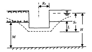
Study on Deep Well Dewatering Optimization Design in Deep Foundation Pit and Engineering Application
Chunlin Hu, Huijun Yang
2002, 13(1): 78-82.
Abstract:

Based on analyses of the theories of groundwater unsteady flow in deep well dewatering in the deep foundation pit, Theis equations are chosen to calculate and analyze the relationship between water level drawdown of confined aquifer and dewatering duration. In order to reduce engineering cost and diminish detrimental effect on ambient surrounding, optimization design target function based on the control of confined water drawdown and four restriction requisitions based on the control of safe water level, resistance to throwing up from the bottom of foundation pit, avoiding excessively great subsidence and unequal surface subsidence are proposed. A deep well dewatering project in the deep foundation pit is optimally designed. The calculated results including confined water level drawdown and surface subsidence are in close agreement with the measured results, and the optimization design can effectively control both surface subsidence outside foundation pit and unequal subsidence as a result of dewatering.

Discrete Element Analysis of Huangtupo Landslide
Guanfeng An, Kunlong Yin, Huiming Tang
2002, 13(1): 83-85.
Abstract:

On the basis of the deep geology and the geological structure of Huangtupo landslide, an ancient landslide in the reservoir of the Three Gorges, the geo-environmental model of the landslide is established to analyze quantitatively the sliding mechanism by using the discrete element method. It is concluded that interbedding structure of soft and hard formation consists of the main geological background, which induced the arching of the formation under gravity. Stability analysis of different loadings shows that the ground building weight on the middle slope may restrain the extension of shear sliding zone below, but may activate the foot area which will reduce the safety factor of the front.

Multiwave Amplitude Compensation and Its Sensitivity Analysis to AVO Inversion in Viscoelastic Media
Hanming Gu, Jiaying Wang, Guangming Zhu
2002, 13(1): 86-90.
Abstract:

We derive formulae of correction for multi-wave geometric spreading and absorption in layered viscoelastic media, this provides the theoretical foundation for true amplitude compensation of field data and for our sensitivity analysis. The imaging matrix at a plane reflector between viscoelastic media can be determined in the frequency domain using linearized reflection coefficients through Born approximation. We quantitatively analyze the sensitivity by studying eigenvalues and eigenvectors of the imaging matrix. The results show that two linear combinations of petrophysical parameters can be determined from the multi-wave AVO inversion in the case of amplitude compensation. Multi-wave AVO contains the information of attenuation in the media. However, the sensitivity of multi-wave AVO inversion to attenuation is small.

CCSD Well Logging Engineering Program
Heping Pan, Ylxiong Niu, Wenxian Wan
2002, 13(1): 91-94.
Abstract:

This paper introduces briefly the tasks and characteristics of China Continent Science Drilling (CCSD) Well Logging Engineering, the logging methods measured with CCSD, the quality control of original logging information, the logging plan of CCSD, the logging engineering management of CCSD, the logging interpretation and the results and reports made with CCSD.