Advanced Search

Indexed by SCI、CA、РЖ、PA、CSA、ZR、etc .

2010 Vol. 21, No. 4

Display Method:
Research
Modeling the Contemporary Stress Field and Deformation Pattern of Eastern Mediterranean
S K Dwivedi, D Hayashi
2010, 21(4): 365-381. doi: 10.1007/s12583-010-0100-6
Abstract:
The contemporary stress field in the earth's crust is important and provides insights into mechanisms that drive plate motions. In this study, elastic plane stress finite element modeling incorporating realistic rock parameters was used to calculate the stress field, displacement field, and deformation of the plate interactions in the eastern Mediterranean. Modeled stress data for the African-Arabian-Anatolian plate interactions with fixed European platform correlate well with observed contemporary stress indicator from the world stress map (WSM) and focal mechanism of earthquakes; while displacement field agrees qualitatively well with GPS vectors and sense of motion indicated by focal mechanisms for large crustal earthquakes (Ms > 6) and plate motion models. Modeling result shows the direction of maximum horizontal compressive stress (σHmax) toward the direction of absolute motion of these plates. Large perturbations in σHmax orientations are shown to occur in and around tectonic boundaries between those plates. It is observed that, although the African plate acts mostly as indenter, which transmits the collisional motion from the Arabian plate to the Anatolian plate, in the current situation, the far-field stress, probably from the subduction in Aegean Arc, is needed to satisfy the contemporary stress field in Anatolia.
Variation in Solvent-Extractable Lipids and n-Alkane Compound-Specific Carbon Isotopic Compositions with Depth in a Southern China Karst Area Soil
Jingwei Cui, Junhua Huang, Philip A Meyers, Xianyu Huang, Jingjing Li, Wengui Liu
2010, 21(4): 382-391. doi: 10.1007/s12583-010-0101-5
Abstract:
Because literatures about the lipid compositions of modern soils in karst areas are scarce, we have studied the soil horizons overlying the Heshang (和尚) Cave that has provided paleoclimate records from speleothem lipid contents. Our analysis reveals a series of n-alkanes, free fatty acids, n-alkanols and n-alkan-2-ones distribution and relative abundance changing with the depth, and in which the ratios of the lower molecular weight to higher molecular weight n-alkanes, free fatty acids, n-alkanols and n-alkan-2-ones have a peak at a subsurface depth of 5 to 10 cm. An accompanying peak in 17β(H), 21β(H)-hop-22(29)-ene (diploptene) and a shift to less negative n-alkane carbon isotopic values also identify this layer in the karst soil. This pattern indicates the existence of a subsurface soil layer in which the microorganisms that produce these compounds are especially abundant. The carbon isotopic values of individual plant wax n-alkanes are about 3‰ greater at the base of the 30- to 40-cm soil profile than in the surface layer, probably as a result of selective microbial degradation of n-alkanes from different primary sources. The lipids and carbon isotopic values of individual plant wax n-alkanes study of the overlying soil show a strong microbial activity in this karst soil and help in interpreting the lipid compositions and specific carbon isotopic value of n-alkanes of the stalagmites of the Heshang Cave for paleoenvironmental reconstructions.
Re-Os Geochronology of Porphyry Molybdenum Deposit in South Segment of Da Hinggan Mountains, Northeast China
Qingdong Zeng, Jianming LIU, Zuolun Zhang
2010, 21(4): 392-401. doi: 10.1007/s12583-010-0102-4
Abstract:
The ages for porphyry Mo deposits in south segment of Da Hinggan Mountains, Northeast China, are not well known. Five molybdenite samples from the Aolunhua (奥伦花) porphyry Mo deposit, five molybdenite samples from the Yangchang (羊场) porphyry-quartz vein Mo deposit and two molybdenite samples from the Banlashan (半拉山) porphyry Mo deposit were selected for Re-Os dating. Three deposits are spatial-temporally associated with the granite porphyry stock. Re-Os isochron age of 131.2±1.9 Ma was obtained for the Aolunhua porphyry Mo deposit. The Yangchang Mo deposit provides isochron age of 138.5±4.5 Ma for two groups of molybdenite (within porphyry ore and within quartz vein). The Banlashan porphyry Mo deposit provides model ages of 140.5±2.4 and 143±2.2 Ma. All of these Re-Os ages are consistent presumed Yanshanian ages for granite intrusions, formed in crust thinning setting in Cretaceous in North China.
Experimental Determination of Calcite Dissolution Rates and Equilibrium Concentrations in Deionized Water Approaching Calcite Equilibrium
Qingjie Gong, Jun Deng, Qingfei Wang, Liqiang Yang, Min She
2010, 21(4): 402-411. doi: 10.1007/s12583-010-0103-3
Abstract:
The calcite dissolution rates at 50–250 ℃ and 20 MPa in deionized water with flow rate varying from 0.2 to 5 mL/min were experimentally measured in a continuous flow column pressure vessel reactor. Equilibrium concentration (ceq) of calcite dissolution in deionized water at 20 MPa was determined using dissolution data according to the iterative method presented by Jeschke and Dreybrodt. The equilibrium concentrations at 50, 100, 150, 200 and 250 ℃ are 1.84×10⁻⁴, 2.23×10⁻⁴, 2.25×10⁻⁴, 2.31×10⁻⁴ and 2.24×10⁻⁴ mol/L, respectively. The ceq increases first and then decreases with temperature varying from 50 to 250 ℃ at 20 MPa, and the same variation trend occurs at 10 MPa with lower values. The maximum value (or extremum) of ceq would increase with temperature at constant pressures. The dissolution reaction of calcite in this experiment is approaching the calcite equilibrium, and the reaction order doesn't keep a constant at different temperatures, which could imply that a change of the reaction mechanism was occurring. The Arrhenius equation shouldn't be used to calculate apparent activation energy using rate constant data at different temperatures when the reaction order or reaction mechanism changed.
Tectono-sedimentary Evolution of Piggy-Back Basin: Example from Kuqa Fold and Thrust Belt, Northern Tarim Basin, Northwest China
Minghui Yang, Zhijun Jin, Xiuxiang Lü, Dongsheng Sun, Peng Zeng
2010, 21(4): 412-422. doi: 10.1007/s12583-010-0104-2
Abstract:
The Baicheng (拜城) piggy-back basin was part of the intracontinental foreland basin system of southern Tianshan (天山) Mountains. It was formed on a thrust-and-fold belt induced by Mio-Pliocene collision between southern Tianshan Mountains and Tarim craton that controlled the thick synorogenic basin fills. Sedimentological analysis and a restored cross-section based on seismic data and field studies revealed three tectono-depositional sequences of synorogenic basin fills. (1) The Lower Miocene sequence (Jidike (吉迪克) Formation) was formed under alluvial-braided river-lacustrine environments,in response to geodynamic changes of the Kuqa (库车) fold and thrust belt from the embryonic foreland to a foredeep in the course of orogenic loading period. (2) The Upper Miocene sequence (Kangcun (康村) Formation) was developed in fluvial-delta and lacustrine environments,within a foredeep due to orogenic thrust. (3) The Pliocene sequence (Kuqa Formation) was formed in the Baicheng piggy-back basin that became a wedge-top depozone,thrusting in the Qiulitagh (秋里塔格) thrust belt that propagated progressively southward to the Yaken (牙肯) thrust belt.
High-Resolution Transgressive-Regressive Sequence Stratigraphy of Chang 8 Member of Yanchang Formation in Southwestern Ordos Basin, Northern China
Mingsheng Lü, Kaiyuan Chen, Liangqing Xue, Liping Yi, Hongtao Zhu
2010, 21(4): 423-438. doi: 10.1007/s12583-010-0105-1
Abstract:
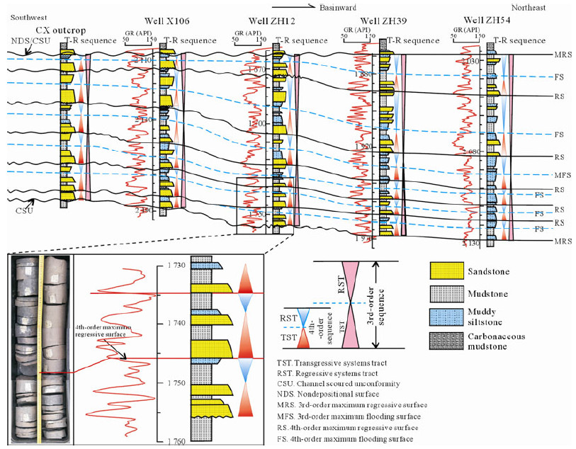
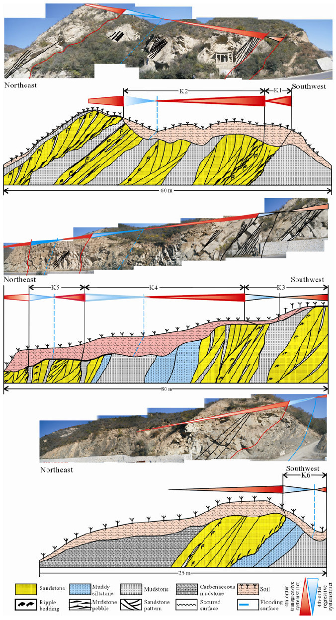
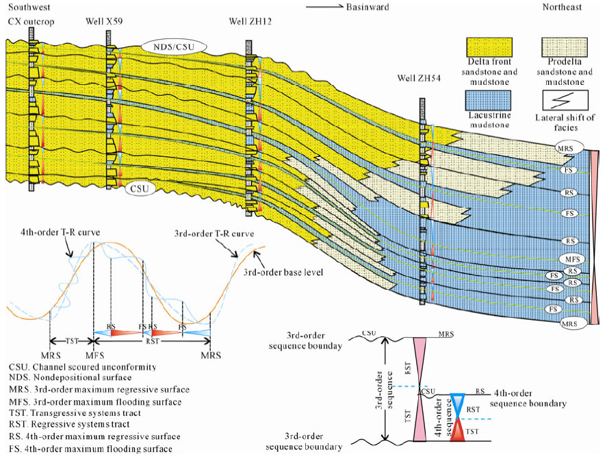
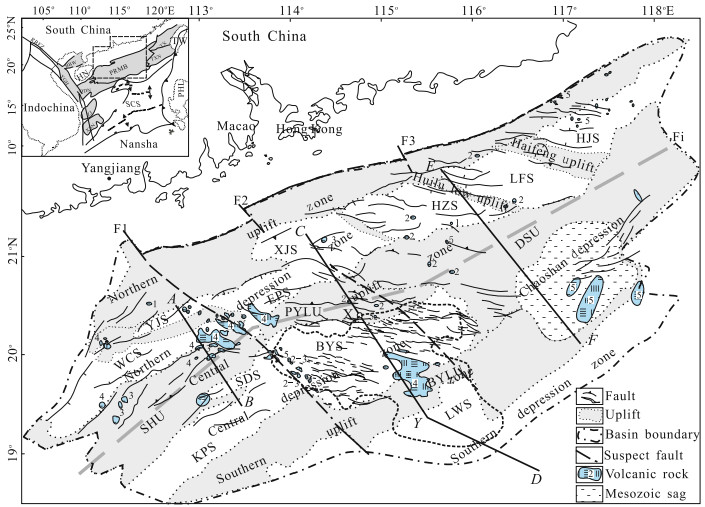
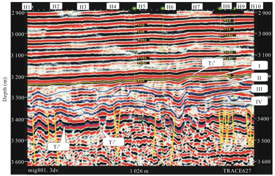
The reservoirs within the Chang 8 Member of Yanchang (延长) Formation in the southwestern Ordos basin are characterized by low permeability. It is significant to build a high-resolution sequence stratigraphic framework for the exploration and development of these reservoirs. Based on an integrated investigation of well logs, seismic data, cores and outcrops, the Chang 8 Member is interpreted as a 3rd-order transgressive-regressive (T-R) sequence, which consists of six 4th-order T-R sequences, namely, K1, K2, K3, K4, K5 and K6, respectively, from base to top. Each 4th-order sequence comprises a transgressive systems tract overlain by a regressive systems tract. From K1 to transgressive systems tract of K4, it is characterized by the landward shifts of facies and overall retrogradational sequence stacking pattern due to accommodation increase more than sediment supply during the 3rd-order base-level rise. The distributary channels are mainly deposited in the transgressive systems tracts, and the interdistributary bays, sheet sands, and small-scale mouth bars are primarily developed in the regressive systems tracts in response to the 4th-order base-level fluctuations. From the regressive systems tracts of K4 to K6, it is characterized by the basinward shifts of facies and overall progradational sequence stacking pattern because of accommodation increase less than sediment supply during a fall in 3rd-order base level. The distributary channels are mainly accumulated in the transgressive systems tracts, and distributary channels and mouth bars are deposited in the regressive systems tracts as a result of the 4th-order base-level changes. Detailed stratigraphic and sedimentological analyses indicate that sequences K1, K2, K5 and K6, as well as the basin edge of K3 and K4, remain potential for exploration and development due to their high reservoir quality in response to the low accommodation and more sediment supply.
Dynamic Analysis on Rifting Stage of Pearl River Mouth Basin through Analogue Modeling
Zhen Sun, Di Zhou, Longtao Sun, Changmin Chen, Xiong Pang, Jianqun Jiang, Hao Fan
2010, 21(4): 439-454. doi: 10.1007/s12583-010-0106-0
Abstract:
The Pearl River Mouth basin (PRMB) is a marginal sedimentary basin of the South China Sea. It trends NE and is divided into three segments from west to east by two NW-trending faults. Changing dramatically in structures along and across strike,the PRMB is a good example to analyze main factors that might control the process of a continental rift basin's extension. Through five series of analogue experiments,we investigate the role of different factors,such as pre-existing discontinuities of crust,rheological profiles of lithosphere,kinematics of extension and presence of magmatic bodies and strong crustal portions (rigid massifs) on the development of basin's structures. After being compared with the architecture of the natural prototype,the results of the analogue models were compared with the architecture of the natural prototype and used to infer the role of the different factors controlling the formation and evolution of the PRMB. The main conclusions are as follows. (1) Affected by pre-Cenozoic structures,the PRMB was controlled by crosscut NE- and NW-trending initial faults,and the NW-trending Yitong'ansha (一统暗沙) fault may be a through-going fault along dip and offset the NE-trending rift and faults,while the Enpingdong (恩平东) fault might exist only in the middle and south. (2) The NW-trending faults may orient WNW to be sinistrally transtensional under SE to nearly NS extension. (3) The thickness ratio of brittle over ductile crust in Baiyun (白云) sag is less than normal,suggesting an initially hot and weak lithosphere. (4) The magma must have taken part in the rifting process from early stage,it may occur initially upon or slightly south of the divergent boundary in the middle segment. The flow of magma toward rift boundary faults caused extra vertical subsidence above the initial magma reservoir without creating a large extensional fault. (5) The rigid massif contributed to the strain partition along and across basin strike.
Oil Cracking of Deep Petroleum in Minfeng Sag in North Dongying Depression, Bohai Bay Basin, China: Evidence from Natural Fluid Inclusions
Hongwei Ping, Honghan Chen, Guoqi Song, Huimin Liu
2010, 21(4): 455-470. doi: 10.1007/s12583-010-0107-z
Abstract:
A fluid inclusion fluorescence and microthermometric study was performed on sandstones from the deep Es4 reservoir rocks of the Minfeng (民丰) sag, north of Dongying (东营) depression. Two types of oil inclusions (yellow and blue white fluorescence), one type of gas inclusions (blue white fluorescence), and bitumen inclusions (no fluorescence) were detected within quartz and feldspar minerals. The evolution of hydrocarbon fluid inclusions in the lower Es4 sequence indicates that present oil accumulation was predominantly thermal stress controlled. Homogenization temperatures of aqueous fluid inclusions coexisting with gas-bearing and bitumen-bearing fluid inclusions indicate that oil cracking occurred at temperatures up to 160 ℃, primary condensate or wet gas generation occurred during 170–195 ℃. Oil has cracked into condensate or wet gas in the depth of 4 300–4 410 m and dry gas and abundant pyrobitumen in the depth of more than 4 410 m in the geological history based on the fluid inclusion extrapolation. Secondary oil cracking is undergoing in present day when the depth of reservoir is more than 4 150 m whose temperature is the threshold temperature of oil cracking (160 ℃). However, because of the consumption of oil in the first oil cracking process, it may have few chances to find liquid petroleum, and only natural gas can be found when the depth of reservoir is more than 4 410 m, where oil cracks into condensate gas or wet gas according to present-day formation temperature. This study is preliminary but foreshadows a new insight into oil cracking using natural fluid inclusions to trace hydrocarbon evolution in sedimentary basins.
Seismic Sedimentology and Its Application in Shallow Sea Area, Gentle Slope Belt of Chengning Uplift
Xianguo Zhang, Chengyan Lin, Tao Zhang
2010, 21(4): 471-479. doi: 10.1007/s12583-010-0108-y
Abstract:
Seismic sedimentology is a new frontier inter-discipline subject, and shows good prospect and potentiality in reservoir deposition research with seismic data and geophysics technologies. We made seismic sedimentology research of shallow sea area, gentle slope belt of Chengning (埕宁) uplift, Bohaiwan (渤海湾) basin. In shallow sea area with sparse well coverage, it was difficult to characterize the reservoir architecture with the traditional method based on wells. A new method to resolve the above problems is built: (1) information on plane and in section is inter-calibrated with each other; (2) recognize the isochronic surfaces by frequency decomposition and interpret the depositional character with technology of stratal slicing; (3) make a comprehensive research with the stratal slice interpretation and the dissection of well group. The depositional model of this area is built and used in the architecture analysis of area without wells. The architecture description reveals that the sedimentary character of pan-connection sand bodies in braided rivers is the reason for high water cut of the new horizontal wells.
Lateral Contrast and Prediction of Carboniferous Reservoirs Using Logging Data in Tahe Oilfield, Xinjiang, China
Heping Pan, Miao Luo, Zeyu Zhang, Zhengjun Fan
2010, 21(4): 480-488. doi: 10.1007/s12583-010-0109-x
Abstract:
Valuable industrial oil and gas were discovered in the formations of Ordovician, Carboniferous and Triassic of the Tahe (塔河) oilfield, Xinjiang (新疆), China. The Carboniferous formations contain several oil- and gas-bearing layers. The lateral distribution of Carboniferous reservoir is unstable, and thin layers are crossbedded. This makes it difficult to do lateral formations' contrast and reservoir prediction, so it is necessary to develop a method that can achieve reservoir lateral contrast and prediction by using multi-well logging data and seismic data. To achieve reservoir lateral contrast and prediction at the Carboniferous formations of the Tahe oilfield, processing and interpretation of logging data from a single well were done first. The processing and interpretation include log pretreatment, environmental correction and computation of reservoir's parameters (porosity, clay content, water saturation, etc.). Based on the previous work, the data file of logging information of multi-well was formed, and then the lateral distribution pictures (2D and 3D pictures of log curves and reservoir parameters) can be drawn. Comparing multi-well's logging information, seismic profiles and geological information (sedimentary sign), the reservoir of the Carboniferous in the Tahe oilfield can be contrasted and predicted laterally. The sand formation of Carboniferous can be subdivided. The results of reservoir contrast and prediction of the Carboniferous formations show that 2D and 3D pictures of multi-well reservoir parameters make the lateral distribution of reservoir and oil-bearing sand very clear, the connectedness of the reservoir of neighboring wells can be analyzed, and five sand bodies can be identified based on the reservoir's lateral distribution, geological information and seismic data.