Advanced Search

Indexed by SCI、CA、РЖ、PA、CSA、ZR、etc .

2012 Vol. 23, No. 1

Display Method:
Research
Silicification in Mississippian Lodgepole Formation, Northeastern Flank of Williston Basin, Manitoba, Canada
Harvey R Young, Rongyu Li, Moe Kuroda
2012, 23(1): 1-18. doi: 10.1007/s12583-012-0229-6
Abstract:
Five types of replacement silica are recognized in the Lower Mississippian Virden Member carbonates on the northeastern flank of Williston basin: microcrystalline quartz, chalcedonic quartz, anhedral megaquartz, euhedral megaquartz, and stringy megaquartz. Silica tends to replace various bioclasts, and all except the stringy megaquartz also occur as non-replacive void-filling cement or as silica forming chert nodules and silicified limestone. Although crinoids, brachiopods, corals, bryozoans, molluscs, trilobites, forams, and ostracodes are present in the sediments studied, only the first three show evidence of silicification. Crinoids are commonly replaced by microcrystalline quartz whereas brachiopods typically by spherules of length slow chalcedony. Coalesced spherules, often in concentric rings (beekite rings), may form sheet-like masses on the surface of corals and brachiopods. Although bryozoans are common in the Virden Member, none showed any evidence of silicification. The difference in the susceptibility to silicification may be related to the shell microstructure, biological group, size of organism, skeletal mineralogy, and organic content of the bioclasts. Biogenic silica derived from the dissolution of siliceous sponge spicules is considered to be the most likely silica source for silicification. Most silica is believed to be released during early diagenesis before the sediments were deeply buried. The Virden Member carbonate may have experienced two episodes of replacement, the first affecting the bioclasts, the second producing silicified limestone and chert nodules.
Pole to Equator Temperature Gradient for Coniacian Time, Late Cretaceous: Oxygen and Carbon Isotopic Data on the Koryak Upland and Hokkaido
Yuri D Zakharov, Olga P Smyshlyaeva, Alexander M Popov, Tatiana A Velivetskaya, Tamara B Afanasyeva, Kazushige Tanabe, Yasunari Shigeta, Haruyoshi Maeda
2012, 23(1): 19-32. doi: 10.1007/s12583-012-0230-0
Abstract:
The purpose of this study was to estimate the Coniacian latitudinal thermal gradient in the Northern Hemisphere. Both hemipelagic (ammonoids) and benthic (brachiopods and bivalves)δ 18O and δ 13C records were used. They originated from Coniacian shallow-water sequences across a wide range of paleolatitudes, from the Koryak upland (northern Kamchatka, Russian Far East) in the north, to Hokkaido (Japan) in the south. Among Coniacian ammonoids, both migrants from Hokkaido living in high latitudes (Kamchatka) and endemic forms dwelling in middle-low latitudes (Hokkaido) indicate seemingly close optimal growth temperatures. Nevertheless, certain differences in climatic conditions, prevailing during high-latitude coldest seasons, undoubtedly provoked growth cessation in some groups of ammonites. Our isotopic study suggests latitudinal temperature changes of only 0.12 ℃ per degree of latitude for the Northern Hemisphere in Coniacian times, while the average annual temperature in North Kamchatka seems about 3.3 ℃ lower than that in Hokkaido.
A New Eosauropterygian (Diapsida: Sauropterygia) from the Middle Triassic of Luoping, Yunnan Province
Long Cheng, Xiaohong Chen, Xiongwei Zeng, Yongjian Cai
2012, 23(1): 33-40. doi: 10.1007/s12583-012-0231-z
Abstract:
A new eosauropterygian, Largocephalosaurus polycarpon gen. et sp. nov., was described based on a skeleton from the Middle Triassic of Luoping(罗平), Yunnan(云南) Province, southwestern China. The new taxon is characterized by a big skull, paired frontal, laterally expanded upper temporal fossa, anterior process of squamosal entering orbit, robust teeth with basally expanded crown and blunt tip, short cervical region, distinctly elongated transverse process of the dorsal vertebrae, short and broad dorsal ribs, stout gastralia, scapula with distinctly posterodorsally extending blade, distinctly robust humerus, eleven carpal ossifications, and a manual fomula of 2-3-4-5-5. A phylogenetic analysis suggests that Largocephalosaurus is the basal-most member of a clade including Wumengosaurus European pachypleurosaurs, and Nothosauroidea.
Olivine Compositional Mapping of Mafic-Ultramafic Complexes in Eastern Xinjiang (NW China): Implications for Cu-Ni Mineralization and Tectonic Dynamics
Benxun Su, Kezhang Qin, He Sun, Dongmei Tang, Qinghua Xiao, Pingping Liu, Patrick Asamoah Sakyi
2012, 23(1): 41-53. doi: 10.1007/s12583-012-0232-y
Abstract:
Early Permian mafic-ultramafic complexes in eastern Xinjiang (新疆) are mainly distributed in the Beishan (北山) area, Mid-Tianshan (天山) massif and Jueluotage (觉罗塔格) belt. Systematic compositional mapping of olivines from these Early Permian mafic-ultramafic complexes demonstrates that an apparently spatial distribution and heterogeneous partial melting in the mantle source exists from the Beishan area, across the Mid-Tianshan massif, to the Jueluotage belt from the south to the north. This is probably consistent with the spatial evolutional differences and tectonic features of these three belts. The decreasing degree of partial melting, as revealed by decreasing Fo contents of olivines, from south to north and from east to west reflects the southward subduction of the Paleo-Asian Ocean and the south location of the indistinct mantle plume in the Permian. Simultaneously, NiO and Fo-mapping in olivine also indicates that sulfide segregation before olivine crystallization played an important role in Ni-Cu mineralization in the mafic-ultramafic complexes. Olivines with the compositional range of Fo (77–86) and NiO (less than 0.22 wt.%) are more favorable for Ni-Cu sulfide mineralization.
Post-Entrainment Mineral-Magma Interaction in Mantle Xenoliths from Inner Mongolia, Western North China Craton
Yamei Wang, Baofu Han, William L Griffin, Lei Zhang, Guiming Shu
2012, 23(1): 54-76. doi: 10.1007/s12583-012-0233-x
Abstract:
In order to distinguish the primary microstructures developed under mantle conditions from the secondary phenomena after xenolith entrainment in the host magma, this study intends to discuss the genesis of spongy, sieve-textured, and reaction rims on mineral grains of mantle xenoliths in the Cenozoic basalts from the western North China craton. The spongy rims on primary clinopyroxene show neither obvious compositional zoning nor preferential development towards the host basalt and probably suggest an origin via partial melting within the lithospheric mantle or pressure release as the xenoliths were carried upwards. The sieve-textured rims on primary spinel show clear chemical zoning with increasing Cr# and decreasing Al towards the host basalt. They are interpreted as the result of partial melting due to heating of the host basaltic magma and decreasing pressure during ascent process. Post-entrainment reaction mainly generated secondary minerals at contacts between the host basaltic melt and xenoliths. The secondary clinopyroxene in reaction rims develops on primary clinopyroxene and has higher Ti, Ca, and Fe contents and lower Mg# and Si contents than primary one, while the secondary spinel on primary Cr-Al spinel is titanomagnetite. The secondary olivine and clinopyroxene in the reaction rims on primary orthopyroxene are enriched in Fe, Al, and Ti. The occurrence of reaction rims in mantle xenoliths reflects disequilibrium processes after xenolith entrainment in the basaltic melt. The spongy rims on primary clinopyroxene may not be related to the interaction with the host basaltic melt, while the sieve-textured rims on primary spinel and reactions rims on primary clinopyroxene, spinel, and orthopyroxene may result from post-entrainment reaction between the host basaltic melt and xenolith minerals.
Application of the Conceptualization Groundwater Data Model to Study the Upper Arkansas River Corridor, Western Kansas
Xiaoying Yang
2012, 23(1): 77-87. doi: 10.1007/s12583-012-0234-9
Abstract:
Large-scale water pumping has caused significant decline in groundwater level in the Upper Arkansas corridor region, which in turn has triggered a chain of hydrological and ecological impacts. A newly developed conceptualization groundwater data model was used to organize various datasets on the Upper Arkansas corridor groundwater system and to develop a MODFLOW model to simulate groundwater flow in the region from 1959 to 2005. The simulation results have shown a significant decline in groundwater level and the conversion of Arkansas River from a gaining river to a losing river in the western two-thirds of the study area. Correlation analysis between percentage of salt cedar and the hydrogeological conditions indicates that these hydrogeological changes at least partially account for invasion of salt cedar that is more drought tolerant. The analysis also illustrates the complexity of the interaction mechanisms between hydrological conditions and salt cedar distribution, and suggests the need for better data on salt cedar distribution with higher spatial resolution and across larger hydrological gradients.
TSR-Derived Quthigenic Calcites in Triassic Dolomite, NE Sichuan Basin, China—A Case Study of Well HB-1 and Well L-2
Sijing Huang, Keke Huang, Zhiming Li, Ming Fan, Ershe Xu, Jie Lü
2012, 23(1): 88-96. doi: 10.1007/s12583-012-0235-8
Abstract:
It has been proven that thermochemical sulfate reduction (TSR) took place extensively in the Lower Triassic carbonate reservoirs in Northeast (NE) Sichuan (四川) basin. We have carried out analyses on bulk rock compositions and isotope ratios together with petrography and fluid inclusions to assess the impact of TSR on diagenetic process of Triassic dolomites. In this article, TSR-related burial diagenesis is characterized by precipitation of calcite cement with negative δ 13C values and high homogenization temperature. The light carbon isotopic compositions of this phase indicate that carbon incorporated in this cement was partly derived from oxidation of hydrocarbon. The high homogenization temperatures indicate that the thermochemical reduction of sulfates has been taking place in the deep part of NE Sichuan basin. Additional evidence supporting this interpretation is the high Sr values of this calcite cement. Moreover, the calcites have aδ 18O of −8.51‰ to −2.79‰ PDB and are interpreted to have precipitated from high salinity fluids with δ 18O of +5‰ to +13‰ SMOW. Under cathodoluminescence, these calcite cements appear dark brown or black, and both Mg concentrations and Mn/Sr ratios are low. It is therefore indicated that seawater was the principal agent of precipitation fluids. Finally, it should be noted that although H2S and CO2 increased as TSR continued, porosity has been ultimately destroyed by calcite cementation.
Landslide Hazard Mapping Using GIS and Weight of Evidence Model in Qingshui River Watershed of 2008 Wenchuan Earthquake Struck Region
Chong Xu, Xiwei Xu, Fuchu Dai, Jianzhang Xiao, Xibin Tan, Renmao Yuan
2012, 23(1): 97-120. doi: 10.1007/s12583-012-0236-7
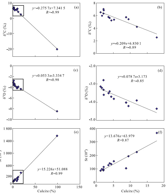
Abstract:
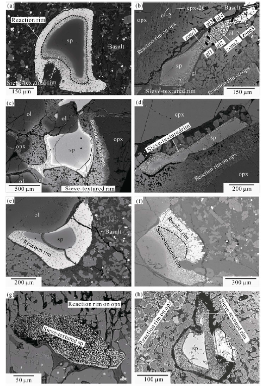
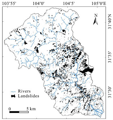
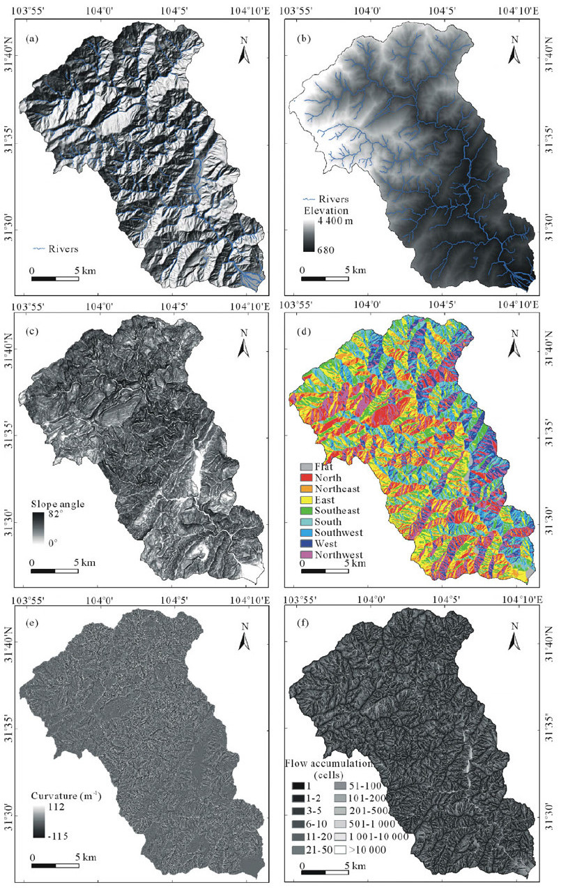
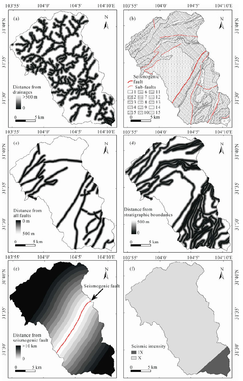
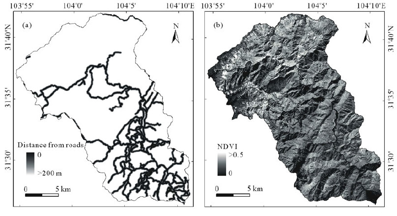
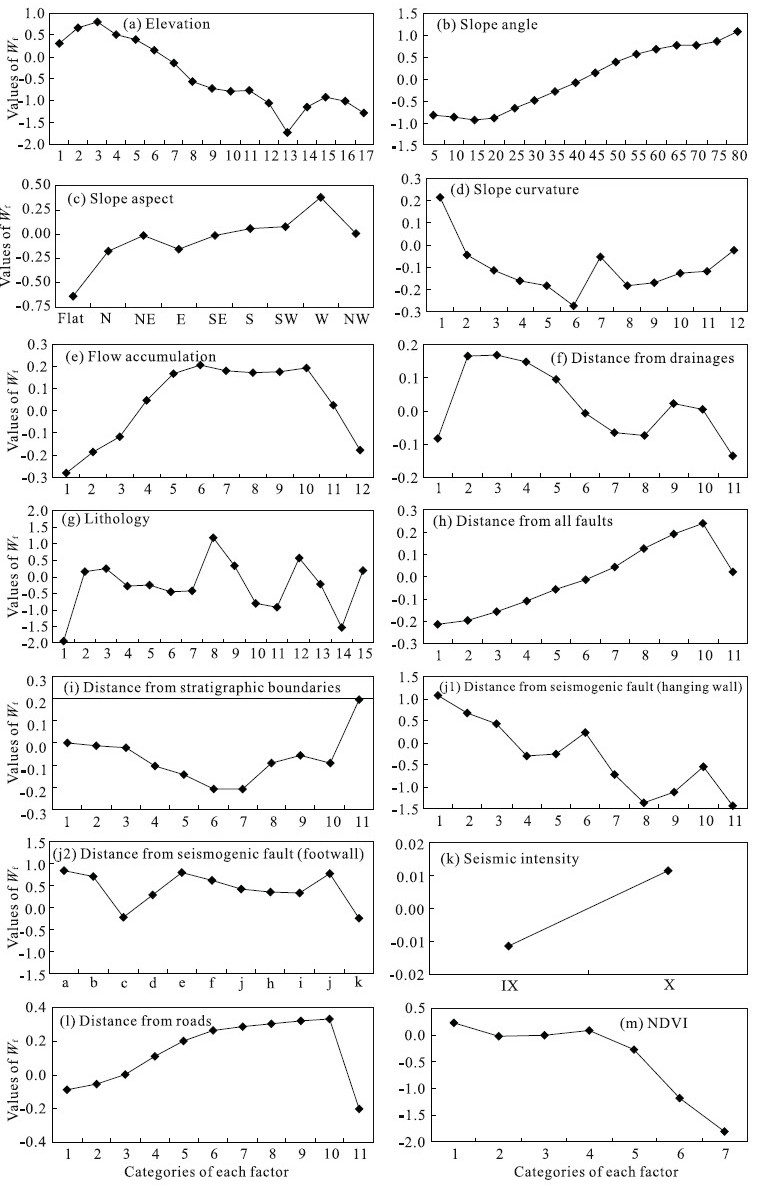
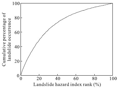
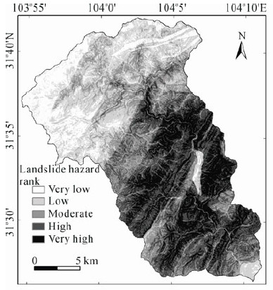
Tens of thousands of landslides were triggered by May 12, 2008 earthquake over a broad area. The main purpose of this article is to apply and verify earthquake-triggered landslide hazard analysis techniques by using weight of evidence modeling in Qingshui (清水) River watershed, Deyang (德阳) City, Sichuan (四川) Province, China. Two thousand three hundred and twenty-one landslides were interpreted in the study area from aerial photographs and multi-source remote sensing imageries post-earthquake, verified by field surveys. The landslide inventory in the study area was established. A spatial database, including landslides and associated controlling parameters that may have influence on the occurrence of landslides, was constructed from topographic maps, geological maps, and enhanced thematic mapper (ETM+) remote sensing imageries. The factors that influence landslide occurrence, such as slope angle, aspect, curvature, elevation, flow accumulation, distance from drainages, and distance from roads were calculated from the topographic maps. Lithology, distance from seismogenic fault, distance from all faults, and distance from stratigraphic boundaries were derived from the geological maps. Normalized difference vegetation index (NDVI) was extracted from ETM+ images. Seismic intensity zoning was collected from Wenchuan (汶川)Ms8.0 Earthquake Intensity Distribution Map published by the China Earthquake Administration. Landslide hazard indices were calculated using the weight of evidence model, and landslide hazard maps were calculated from using different controlling parameters cases. The hazard map was compared with known landslide locations and verified. The success accuracy percentage of using all 13 controlling parameters was 71.82%. The resulting landslide hazard map showed five classes of landslide hazard, i.e., very high, high, moderate, low, and very low. The validation results showed satisfactory agreement between the hazard map and the existing landslides distribution data. The landslide hazard map can be used to identify and delineate unstable hazard-prone areas. It can also help planners to choose favorable locations for development schemes, such as infrastructural, buildings, road constructions, and environmental protection.
Health risks of organic contaminated soi l in an out-of-service oil refinery site
Yongpeng Hua, Zejiao Luo, Shenggao Cheng, Rui Xiang
2012, 23(1): 121-128. doi: 10.1007/s12583-012-0237-6
Abstract:
Health risks assessment due to exposure to organic contaminated soil at an oil refinery out of service is conducted in this study by integrating health risk methods of U.S. EPA (United States Environmental Protection Agency), ASTM (American Society for Testing and Materials) and VROM (Ministry of Housing, Spatial Planning and the Environment in Netherlands), with the localized parameters using Chinese demographic characteristics and site features. The monitoring results show that the concentration of benzene, benzo(a)pyrene and benzo(a)anthracene in the soil of the site all exceed their risk screening values, respectively, with pollutants concentrated in soil 0.1–5.5 m beneath the surface. To estimate health risks of the site with the 95% upper confidence limit of the pollution, we focus on three major exposure pathways, namely, oral ingestion, dermal contact and breath inhalation, which indicates carcinogenic risk (CR) and non-carcinogenic hazard quotient (HQ) of the contaminated soil reach 9.59×10⁻⁵ and 15.46, respectively, exceeding the acceptable level of 10−5 and 1, posing severe health hazards to the residents at the site.