Advanced Search

Indexed by SCI、CA、РЖ、PA、CSA、ZR、etc .

2012 Vol. 23, No. 3

Display Method:
Research
Petroleum Charging and Leakage in the BZ25-1 Field, Bohai Bay Basin
Fang Hao, Xinhuai Zhou, Huayao Zou, Changyu Teng, Yuanyuan Yang
2012, 23(3): 253-267. doi: 10.1007/s12583-012-0251-8
Abstract:
This paper discusses origin and charging histories of the Bozhong (渤中) 25-1 field (BZ25-1) in the Bozhong sub-basin, Bohai (渤海) Bay basin. Petroleum is contained in both Paleogene and Neogene reservoirs in the BZ25-1 field. The origin of the field was studied using biomarker distributions for 61 source rock samples and 34 oil samples. Oil in the Paleogene reservoirs was derived from the third member (Es3, 43.0–38.0 Ma in age) of the Eocene Shahejie (沙河街) Formation, whereas oil in the Neogene reservoirs was a mixtures of oil generated from the third member and the first member (Es1, 35.8–32.8 Ma) of the Eocene Shahejie Formation. Charging of the shallow Neogene reservoirs was dynamic, probably ongoing, which was a combined result of the existence of active source rocks, the development of overpressure and the fault reactivation since about 5.1 Ma. On the contrary, the deep Paleogene reservoirs experienced intensive oil leakage as indicated by the high GOI (grains-containing-oil-inclusions) values (up to 30%) for samples below the present-day oil-water contact. Part of the oil that leaked from the Paleogene reservoirs re-accumulated in the shallow Neogene reservoirs. The variation of oil origins within the BZ25-1 field, and the dynamic petroleum charging into the shallow Neogene reservoirs and leakage from the deep Paleogene reservoirs have important implications for petroleum exploration.
The Late Mesozoic Granodiorites from the Southwest Basin in the South China Sea and Its Tectonic Implication
Zhenguo Zhang, Yuansheng Du, Lianfeng Gao, Nianqiao Fang, Shengxiong Yang, Jian Liu, Chengbing Song
2012, 23(3): 268-276. doi: 10.1007/s12583-012-0252-7
Abstract:
The southwest basin is a key to study the origin and development of the South China Sea (SCS). We do not know much about its boundaries, geological history, and the formation of its sea floor because it has a complex and highly regional structural background, notable sediment activity, and yet few floor rocks. Here a granodiorite sample was collected from the southern margin of the southwest basin of the South China Sea. The results indicated that the40Ar-39Ar ages of biotites in the sample are 110.3±0.5 Ma, suggesting that they were products of magmatic intrusion during the Early Cretaceous period. The sample's geochemistry showed it had high SiO2, K2O, and Al2O3 but low TiO2 levels. Tectonic discriminant diagrams suggested that the sample might represent extrusion-related magmatism, either in an arc or forearc setting in the SCS area and that the sample mainly belonged to the syncollision type, whose formation was related to orogenies. The sample may be part of the main rock that made up the boundaries of rift system. The process of tension cracking was similar to the development of the Red Sea, in which the rifting and sagging occurred in the continental crust. The southwest basin may not be an original ocean, but a rift developed through finite extension on continental crust basement. The oceanic crust came into being when the width and depth of the rift valley reached a certain scale. The granodiorite sample we collected provides a means of determining the boundary of the southwest basin and the clues that may help researchers expand relevant models. It constitutes an important datum regarding the analysis of the formation and development of the SCS.
The Neoarchean Ophiolite in the North China Craton: Early Precambrian Plate Tectonics and Scientific Debate
Timothy M Kusky, Mingguo Zhai
2012, 23(3): 277-284. doi: 10.1007/s12583-012-0253-6
Abstract:
Archean greenstone belts and their possible inclusion of fragments of ophiolites is an important research subject, since it is correlated with the nature of early oceanic crust, and can yield information on the nature of early planetary lithospheres, the origin of TTG (tonalite-trondhjemite-granodiorite) continental crust, the formation of early cratons and continents, and is related to when plate tectonics started in the Earth's evolutionary history. This article briefly reviews the North China craton's Archean ophiolite argument and proposes further studies aimed at understanding the generation of greenstone belts and Archean ophiolites, and suggests some key scientific questions that remain to be answered.
Analysis of Slope Stability with Dynamic Overloading from Earthquake
Ti Zhao, Jinzhong Sun, Bin Zhang, Cheng Li
2012, 23(3): 285-296. doi: 10.1007/s12583-012-0257-2
Abstract:
The analysis of slope earthquake stability is one of the most important research subjects in geotechnical engineering and earthquake engineering. Two different concepts of slope earthquake stability are put forward: strength reserve stability and dynamic overloading stability. The first concept of slope earthquake stability has been widely accepted,and relative analysis methods are also well developed; the second one,however,is seldom mentioned until now,and the failure criterion and the analysis method based on this concept are yet to be explored. What are researched are just the failure criterion and the analysis method of dynamic overloading earthquake stability. The criterion of critical earthquake peak acceleration for the dynamic overloading stability of a slope and its analysis method,the load increasing method (LIM),are put forward. The dynamic overloading earthquake stability of a loess slope at Changshougou (长寿沟) in Baoji (宝鸡) City,Shaanxi (陕西) Province,China,is analyzed with LIM. The analysis result reveals that the dynamic overloading earthquake stability of the slope is quite high to the action of the earthquake ground motion,with exceeding probability of 10% in the next 50 years.
Paleoenvironmental Changes in the Northern Okinawa Trough since 25 ka BP: REE and Organic Carbon Evidence
Zhaokai Xu, Tiegang Li, Qingyun Nan, Xinke Yu, Anchun Li, Jinyong Choi
2012, 23(3): 297-310. doi: 10.1007/s12583-012-0254-5
Abstract:
Paleoenvironmental changes in the northern Okinawa trough covering the last 25 ka were synthetically reconstructed using REE and organic carbon indices of core CSH1. Variations of these parameters revealed three distinct intervals of major sediment provenance changes that can be related to sea-level fluctuation and Tsushima Warm Current evolution. Interval 1 (16–24.7 ka BP) is characterized by dominantly fluvial discharge from the Changjiang (Yangtze River) and Huanghe (Yellow River) as well as high primary productivity. In Interval 2 (7.3–16 ka BP), the Changjiang and Huanghe mouths regressed with sea-level rising. The newly formed Tsushima Warm Current could carry some sediment loads of Taiwan to the study core, especially during its late phase (7.3–8.2 ka BP). Modern oceanographic conditions were finally established since the beginning of Interval 3, leading to more terrigenous contribution from Taiwan, whereas low sea-surface productivity in the study area.
Conodont Biostratigraphy and Evolution across Permian–Triassic Boundary at Yangou Section, Leping, Jiangxi Province, South China
Dongying Sun, Jinnan Tong, Yanlin Xiong, Li Tian, Hongfu Yin
2012, 23(3): 311-325. doi: 10.1007/s12583-012-0255-4
Abstract:
Series of large conodont samples with 20 species and 3 similar species in 3 genera were collected from the Permian-Triassic (P-T) boundary sequence in a shallow carbonate facies at Yangou (沿沟),Leping (乐平) County,Jiangxi (江西) Province,South China. On the basis of the distributions of the identified species,seven conodont zones have been recognized in ascending order as follows,Neogondolella changxingensis zone,Neogondolella yini zone,Hindeodus changxingensis zone,Neogondolella taylorae zone,Hindeodus parvus zone,Isarcicella staeschei zone,and Isarcicella isarcica zone. The successive occurrences of Hindeodus changxingensis,Neogondolella taylorae and Hindeodus parvus serve as proxies for defining the P-T biostratigraphy boundary at the base of Sub-bed 21-4 of Bed 21 in the Yangou Section. Correlations with the Meishan Section are also discussed in terms of conodont biostratigraphy. Three successive conodont faunal assemblages are grouped through the P-T transitional interval to examine the evolution of conodonts across the great transitional event.
Stability of Huangtupo Riverside Slumping Mass II# under Water Level Fluctuation of Three Gorges Reservoir
Xinli Hu, Huiming Tang, Changdong Li, Renxian Sun
2012, 23(3): 326-334. doi: 10.1007/s12583-012-0259-0
Abstract:
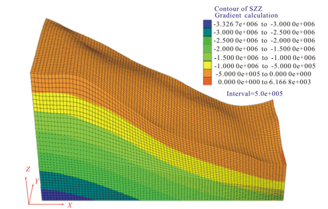
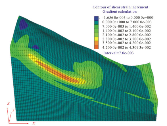
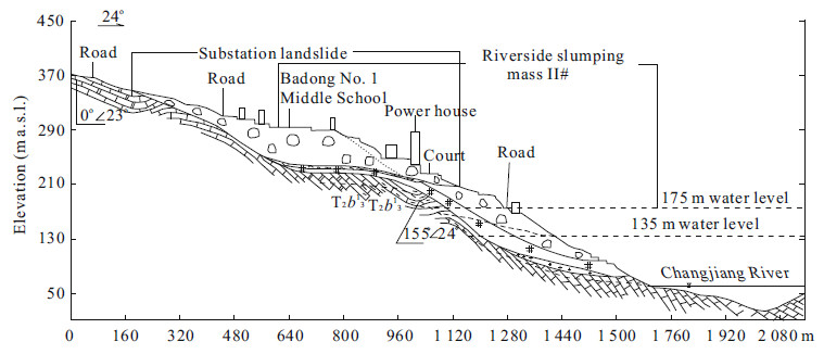
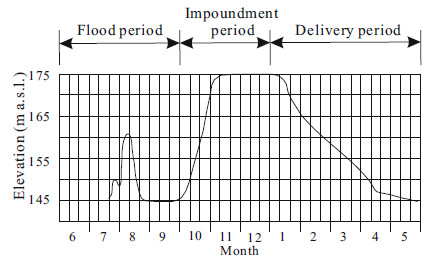
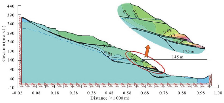
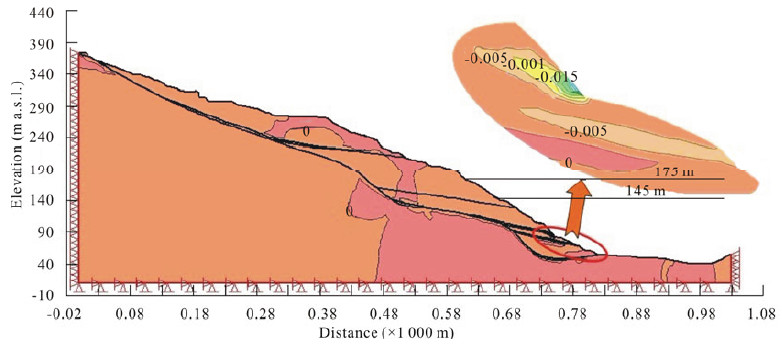
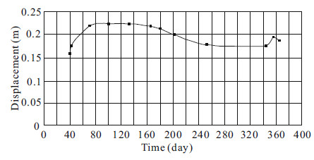
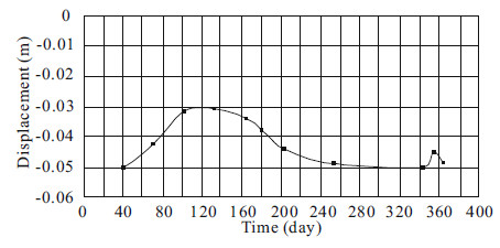
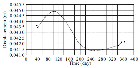
After the normal operation of the Three Gorges Reservoir, the water level of the reservoir will fluctuate periodically. Water level fluctuation will soften the rock and soil on the banks, induce underground water fluctuation and decrease the shear strength of rock soil on the banks, and in turn affect the landslide stability. The Huangtupo (黄土坡) landslide is a typical large and complex landslide in the Three Gorges Reservoir region. In particular, the stability of its riverside slumping mass has a great stake. On the basis of the analysis of engineering geological condition and formation mechanism of the Huangtupo landslide, the authors established the 2D finite element model of riverside slumping mass II# and selected proper mechanical parameters of the rock. With the GeoStudio software, according to the reservoir running curve, the simulation on coupling effect of seepage field and stress field was conducted in 7 different modes in a year. The results showed that: ➀ Huangtupo landslide is a large and complex landslide composed of multiple slumping masses, which occurred at different phases. Before reservoir impoundment, it was stable; ➁ it is quite difficult for riverside slumping mass I# and II# to slide as a whole; ➂ the stability coefficient of riverside slumping mass II# changes with the reservoir water level fluctuations. The minimum stability coefficient occurs 48 days after the water level starts to fall and the moment when the water level falls by 11.9 m. Landslide monitoring result is consistent with the numerical simulation result, which shows that although the reservoir water level fluctuation will affect the foreside stability of the landslide and induce gradual damage, the riverside slumping mass II# is stable as a whole.
Health Risk Assessment of Groundwater Pollution—A Case Study of Typical City in North China Plain
Mei Yang, Yuhong Fei, Yiwen Ju, Zhen Ma, Huaqi Li
2012, 23(3): 335-348. doi: 10.1007/s12583-012-0260-7
Abstract:
This article presents an application of assessing human health risk in typical city of North China plain. Combined with water quality and multi-element analysis, Pb, Cd, Cr6+, Mn, NO3 , F, and As in groundwater samples were chosen to be used for human health risk assessment of drinking water pathway and dermal contact pathway, and results show a good effect. Results indicate that (1) poor water quality is caused by salinity and hardness overstandard; (2) in noncarcinogenic risk, samples that do not pose noncarcinogenic risk only account for 28.46%; in carcinogenic risk, samples that do not pose carcinogenic risk account for 73.08%; (3) the noncarcinogenic risk in the study area decreased in the following order: NO3 > Mn > As > F > Cr6+ > Cd > Pb and the carcinogenic risk of the study area decreased in the following order: As > Cd=NO3 =Mn=F=Cr6+=Cd=Pb=0, because the slop factors were not available for the other pollutants, except for As; and (4) in terms of whole study area, the main contribute order of drinking water pathway and dermal contact pathway in human body is drinking water pathway > dermal contact pathway.
Approach to the Relation of Mutual-Feed Joint-Variation in Groundwater Management Model
Ping Li, Wenxi Lu, Menggui Jin, Qingchun Yang
2012, 23(3): 349-358. doi: 10.1007/s12583-012-0261-6
Abstract:
In groundwater management,the exchanges between groundwater and other water such as surface water and spring water need to be considered. Some exchange is dependent on the groundwater level,which is called covariate. The pumping rate,groundwater level,and covariate interact and the relation of mutual-feed joint-variation is used to describe their interaction. This article presents a new approach of dealing with the relation in groundwater management model. The mathematical formulation of the relation,as an additional equality constraint in the optimization model,is developed using response matrix method. Thereby the groundwater management model with covariate is set up. The code for the simulation and management of groundwater system with covariate is programmed with Fortran 90,and the optimal pumping rate,groundwater level,and covariate are obtained. The approach is verified with a hypothetical case. Finally,the approach is applied to the groundwater management of Qianguo (前郭) area in western Jilin (吉林) Province. The results indicate that the approach is feasible. It provides a universal solution for various covariates and reduces the computational complexity compared to iteration method. The approach is proven to be very efficient to solve groundwater management problem with covariate.
Yinggehai Basin Gas Exploration: Comparison with Jiyang Depression
Zhifeng Wan, Bin Xia, Baofeng Lü, Zhourong Cai, Weiliang Liu
2012, 23(3): 359-372. doi: 10.1007/s12583-012-0256-3
Abstract:
Yinggehai (莺歌海) basin and Jiyang (济阳) depression experienced similar tectonic evolution, which is mainly controlled by the strike-slip faults. The strike pull-apart basins are characteristic by multiple deposition cycles, migration of deposition and subsidence center, and diversity depositional systems. Furthermore, both basins show abnormal formation pressure. Compared with the oil and gas-rich Jiyang depression, Yinggehai basin developed the similar geological background that is favorable to the formation of funnel-shaped meshwork-carpet subtle reservoirs. Overpressure diapir body is the core of hydrocarbon accumulation in central diaper zone of Yinggehai basin. Driven by high pressure, oil and gas migrate along the funnel-shaped passage system into the overlying low-potential zone formed. The overlying sand bodies of overpressure diapirs are the favorable gas exploration zone.
Measuring Internal Velocity of Debris Flows by Temporally Correlated Shear Forces
Fangqiang Wei, Hongjuan Yang, Kaiheng Hu, Sergey Chernomorets
2012, 23(3): 373-380. doi: 10.1007/s12583-012-0258-1
Abstract:
Debris flow is a kind of geological hazard occurring in mountain areas. Its velocity is very important for debris flow dynamics research and designing debris flow control works. However,most of past researches focused on surface velocity and mean velocity of debris flow,while few researches involve its internal velocity because there is no available method for measuring the internal velocity for its destructive power. In this paper,a method of temporally correlated shear forces (TCSF) for measuring the internal velocity of debris flows is proposed. The principle of this method is to calculate the internal velocity of a debris flow using the distance between two detecting sections and the time difference between the two waveforms of shear forces measured at both sections. This measuring method has been tested in 14 lab-based flume experiments.