Advanced Search

Indexed by SCI、CA、РЖ、PA、CSA、ZR、etc .

2014 Vol. 25, No. 4

CONTENTS
2014, 25(4): .
Abstract:
Special Issue on Quantitative Characterization and Advances in Oil-Gas Reservoir
Geochronology and Hf Isotopes of Granite Gravel from Fanjingshan, South China: Implication for the Precambrian Tectonic Evolution of Western Jiangnan Orogen
Jinbao Su, Yueqiao Zhang, Shuwen Dong, Xuanhua Chen, Yong Li, Jianjun Cui
2014, 25(4): 619-629. doi: 10.1007/s12583-014-0469-8
Abstract:
The debate of assembly time between the Yangtze and Cathaysia blocks has aroused the disputation on the formation mechanism of Jiangnan orogen, South China. Therefore widespread magmatism of 830–750 Ma in South China is interpreted as the product of either plume or arc magmatism, which results in distinctive depositional background in the Neoproterozoic. Granite gravel located at the unconformity between the Banxi Group and Fanjingshan Group of the western Jiangnan orogen was collected, which gave a new age limit to the deposition of the Banxi Group and Nanhu rift. Zircons from the granite gravel crystallized yield a weighted mean 206Pb/238U age of 789±11 Ma, which probably represents the end of the Jiangnan orogeny and marks the onset of Nanhua rift. These zircons have negative ɛHf(t) of −2.1 to −6.0, with TDM of 1.38–1.52 Ga and Tcrust of 1.81–1.98 Ga indicating an old continental crust origin for the granite.
Lower Crustal Flow and Its Relation to the Surface Deformation and Stress Distribution in Western Sichuan Region, China
Yujiang Li, Lianwang Chen, Pei Tan, Hong Li
2014, 25(4): 630-637. doi: 10.1007/s12583-014-0467-x
Abstract:
The channel flow model was gradually being accepted with the more important multidisciplinary evidences from geology and geophysics, but how the lower crustal flow influenced the surface deformation quantitatively was unknown. Here, we develop a three-dimensional viscoelastic model to explore the mechanical relations between the lower crustal flow and the surface deformation in western Sichuan. Based on numerous tests, our results show that the modeled results fit well with the observed GPS data when the lower crust flows faster than the upper crust about 11 mm/a in the rhombic block, which can be useful to understand the possible mechanism of the surface deformation in western Sichuan. Moreover, taking the Xianshuihe fault as an example, we preliminarily analyze the relation between the active fault and stress field, according to the boundary constraints that deduced from the best model. The results show that the maximum shear stress on the Xianshuihe fault zone is mainly located in the fault terminal, intersections and the bend of the fault geometry, the stress level on the northwestern segment that has the high slip rate is relatively high. Additionally, with the reduction of the Young's modulus in the fault zone, it's conducive to generate the greater strain distribution, hence forming the high stress level.
Differential Geochemical Features of Clinopyroxene from the Floodplain Sediments in Yangtze and Hanjiang Rivers and Its Implication for Detrital Source Identification
Jian Yang, Chang'an Li, Yufen Zhang, N'dji dit Jacques Dembele
2014, 25(4): 638-647. doi: 10.1007/s12583-014-0470-2
Abstract:
The evolution history of the Yangtze River attracted increasing attention in recent years. Comparison of the properties of the floodplain sediments between the upper and lower reaches of the Three Gorges is of significance to identify the material detrital sources for the Yangtze River Basin. Clinopyroxene (Cpx) is the typical mineral widely distributed in the sediments of the Yangtze River Basin. Cpx was extracted from the fine sediments with the grain size ranging from 0.063 to 0.125 mm in the upper and lower reaches of the Three Gorges. The sediments, from which the Cpx was extracted, were taken from the floodplains of the catchments of both the Yangtze River and the Hanjiang River, as well as from the surface of the Zhoulao Core drilled in the center of the Jianghan Basin where the two rivers flow through. Geochemistry of these Cpx was investigated, concerning the contents of major elements measured by electron probe microanalysis (EPMA) and the contents of trace elements analyzed by laser ablation inductively coupled plasma-mass spectrometry (LA-ICP-MS). The Cpx in the Yangtze River contains titaniferous augite which is sourced from the Panzhihua-Xichang region in South Sichuan Province, whereas the Cpx in the Hanjiang River is mainly from the surroundings without any titaniferous augite. The REE analysis infers that the titaniferous augite is the diagnostic mineral of the upper Yangtze River, and thus could be used as a tracer mineral to identify the detrital sources for the sediments formed during the evolution of the Yangtze River. The Cpx from the surface sediments of the Jianghan Plain (Zhoulao Core) shows comparable geochemical nature with that of the Yangtze River, but is different in geochemistry from that of the Hanjiang River, implying that the modern sediments in the Jianghan Plain are mainly sourced from the upper Yangtze River.
Ichnofabrics and Their Environmental Interpretation from the Fluvial Deposits of the Middle Triassic Youfangzhuang Formation in Western Henan, Central China
Min Wang, Yongan Qi, Da Li, Mingyue Dai, Yuguang Chang
2014, 25(4): 648-661. doi: 10.1007/s12583-014-0454-2
Abstract:
Fluvial deposits from the Middle Triassic Youfangzhuang Formation in Henan Province, China contain a low-diversity trace fossils. Vertical dwelling burrows of opportunists dominate in active channel, whereas horizontal deposit-feeding, grazing, and vertical dwelling burrows occur in overbank deposits. Seven recurrent ichnofabrics were distingushed. The Palaeophycus tubularis ichnofabric preserves below scour interface between two fluvial cycles. The Skolithos linearis ichnofabric forms in middle to high-energy, soft substrates in the middle and upper parts of active channel deposits under semi-arid climate. The Skolithos linearis-Planolites montanus ichnofabric occurs in the sediments just a little above the Skolithos linearis ichnofabric and is formed in middle-energy, soft substrates in the upper part of active channel deposits. The Planolites montanus ichnofabric is mostly preserved in association with medium- to thick-bedded brown-red silty mudstones or siltstones in low-energy, perennial muddy bottom ponds in overbank settings. The Taenidium barretti ichnofabric is interpreted as periodically exposed ephemeral ponds or low-energy distal floodplain. The Skolithos isp. ichnofabric commonly occurs in middle to high-energy firm ground of proximal foodplain or crevasse-splay deposits. The root trace ichnofabric occurs in the crevasse splay deposits. The presence of thin palaeosols and the abundance of calcretization in mudstones indicate a seasonal climate ranging from humid to semi-arid, with high temperature, rainfall, and well-defined dry and wet seasons.
Weathering of Carbonate Rocks by Biological Soil Crusts in Karst Areas
Ye Chen, Bin Lian, Zuoying Yin, Yuan Tang
2014, 25(4): 662-667. doi: 10.1007/s12583-014-0455-1
Abstract:
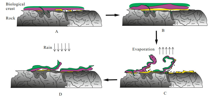
The weathering of carbonate rocks by biological soil crusts (BSC) in karst areas is very common. It is helpful to understand the weathering mechanisms and processes for avoiding karst rock-desertification. The weathering of carbonate rocks by BSC in karst areas, namely the expansion, contraction and curl resulting from environmental wetting-drying cycles, was investigated and analyzed in this paper. The bulk density, area and thickness of BSC were determined and the weathering amount of limestone and dolomite per unit area of BSC was calculated as 3 700 and 3 400 g·m−2; the amount of biomass on the surface of limestone and dolomite was calculated as 1 146 and 1 301 g·m−2, respectively. Such an increased weathering amount was not only the result of chemical and physical weathering of BSC on carbonate rocks, but also the attachment and cementation of BSC to clay particles, dust-fall, sand particles, solid particles brought by strong air currents, wind and other factors in the surrounding environment, which may also be related to the special environment and the special time period. Based on the results obtained, a weathering mode of BSC is studied, and the mechanisms of weathering by BSC are discussed. In conclusion, we suggest that the mechanical force exerted by the expansion and constriction of gelatinous and mucilaginous substances through wetting and drying of BSC play a significant role in the physical weathering process of the carbonate substrates.
Morphogenic Uncertainties of the 2008 Wenchuan Earthquake: Generating or Reducing?
Zhikun Ren, Zhuqi Zhang, Jinhui Yin, Fuchu Dai, Huiping Zhang
2014, 25(4): 668-675. doi: 10.1007/s12583-014-0456-0
Abstract:
Landscape evolution in active orogen region is inevitably affected by landslides associated with strong earthquakes, rain or storm. However, quantitative studies of the orogenic or eroded volumes are rarely demonstrated. The 2008 Wenchuan Earthquake triggered serious landsliding, consequently, a large amount of landslide material. However, the landslide volume is estimated mainly on the landslides areas interpreted in their semi-automated landslide mapping algorithm. However, the total volume of landslides triggered by the Wenchuan Earthquake amounts to 5–10 times bigger than the expected upper bound according to the empirical correlation between "total landslide volume" and "moment magnitude". Here we show that the total landslide volume estimation has large uncertainties to be used to determine whether the Wenchuan Earthquake generates or reduces relief. Thus, the widely held view that large dip-slip and oblique-slip earthquakes build mountainous topography may still be applicable to the Wenchuan Earthquake in Longmen Shan area. To challenge this view, simple landslide volume and co-seismic uplift comparison is not enough, i.e., more data are needed.
Crustal stress state and seismic hazard along southwest segment of the Longmenshan thrust belt after Wenchuan Earthquake
Xianghui QIN, Chengxuan TAN, Qunce CHEN, Manlu WU, Chengjun FENG
2014, 25(4): 676-688. doi: 10.1007/s12583-014-0457-z
Abstract:
The crustal stress and seismic hazard estimation along the southwest segment of the Longmenshan thrust belt after the Wenchuan Earthquake was conducted by hydraulic fracturing for in-situ stress measurements in four boreholes at the Ridi, Wasigou, Dahegou, and Baoxing sites in 2003, 2008, and 2010. The data reveals relatively high crustal stresses in the Kangding region (Ridi, Wasigou, and Dahegou sites) before and after the Wenchuan Earthquake, while the stresses were relatively low in the short time after the earthquake. The crustal stress in the southwest of the Longmenshan thrust belt, especially in the Kangding region, may not have been totally released during the earthquake, and has since increased. Furthermore, the Coulomb failure criterion and Byerlee's law are adopted to analyzed in-situ stress data and its implications for fault activity along the southwest segment. The magnitudes of in-situ stresses are still close to or exceed the expected lower bound for fault activity, revealing that the studied region is likely to be active in the future. From the conclusions drawn from our and other methods, the southwest segment of the Longmenshan thrust belt, especially the Baoxing region, may present a future seismic hazard.
Mineral potential mapping for tungsten polymetallic deposits in the Nanling metallogenic belt, South China
Yue LIU, Qiuming CHENG, Qinglin XIA, Xinqing WANG
2014, 25(4): 689-700. doi: 10.1007/s12583-014-0466-y
Abstract:
The Nanling belt in South China has considerable resources of tungsten polymetallic commodities and is one of the most important metallogenic belts in the world. Data-driven weights-of-evidence (WofE) and fuzzy logic models are used to evaluate the tungsten polymetallic potential of the Nanling belt. Initially, seven ore-controlling factors derived from multi-source geospatial datasets (e.g., geological, geochemical, and geophysical) are used for data integration in the two models. Two mineral potential maps are generated that efficiently predicate the locations of the deposits. The WofE map predicate 81% of the deposits within 13.6% of the study area, whereas the fuzzy logic map predicate 81.5% of the deposits within 13% of the area. The predictive maps are syntheses of spatial association rules, which provide better understanding of those factors that control the distribution of mineralization and trigger eventual exploration work in new areas. Subsequently, in order to evaluate the success rate accuracy, the receiver operating characteristic curves and area under the curves (AUCs) for the two potential maps are constructed. The results show that the AUCs for the WofE and fuzzy logic models are 0.775 7 and 0.840 6, respectively. The higher AUC value for the fuzzy logic model implies that it delineate a greater number of favorable areas compared with the WofE model. Overall, the capabilities of both models for correctly classifying areas with existing mineral deposits are satisfactory.
Cenozoic fault distribution characteristics and evolution in Qikou sag of Bohai Basin, China
Dongdong ZHANG, Chiyang LIU, Yijian HUANG, Siqian CHEN, Yi LU, Zhipan ZHANG
2014, 25(4): 701-712. doi: 10.1007/s12583-014-0458-y
Abstract:
Qikou sag, located in north-center of Huanghua depression in Bohai Basin, is a Cenozoic sag with rich hydrocarbon. As a microcosm of Bohai Basin, the fault characteristics of Cenozoic structural layers in Qikou sag could indicate and record the evolution of Cenozoic stress field in Bohai Basin. Based on the latest 3-D seismic data, the study takes statistics on the fault system of Cenozoic structural layers and analyzes the fault throws of major large faults along the strikes in different periods in Qikou sag, then the fault distribution regularities and the fault direction characteristics in each structural layer are summarized. The result shows that during Cenozoic, the fault activity strength migrates from southwest to northeast and the strikes of faults changes from northwestward in Sha-3 period to nearly east-westward since Sha-1 period.
Novel tetracyclic terpanes in crude oils and source rock extracts in pearl river mouth basin and their geological significance
Ning MA, Dujie HOU, Hesheng SHI
2014, 25(4): 713-718. doi: 10.1007/s12583-014-0468-9
Abstract:
Novel tetracyclic terpanes X and Y namely C24-des-A-oleanane and C27 tetracyclic terpane were detected in crude oils and source rock extracts in Zhu 1 depression in Pearl River Mouth Basin by GC-MS analysis technology. These compounds are similar to oleanane in the structure, and their relative abundance in m/z 191 partial mass chromatogram has a good correlation with oleanane. Here compounds X and Y are considered to be derived from the des-A degradation of oleanoid precursor. The ratio of X/(X+C24) and Y/(Y+C24) increase with the increasing inputs of terrigenous organic matter in crude oils. Wenchang Formation middle-deep lacustrine source rocks with planktonic algae organic matter inputs and oil generating from it contain low abundance of compounds X and Y, while Enping Formation coal measures source rocks with terrigenous higher plants organic matter inputs and oil generating from it usually have higher compounds X and Y. In general when two terrigenous compounds C19 tricyclic terpane and bicadinane-T are high in crude oils, there are also a corresponding high abundant compounds X and Y. Relative abundance of compounds X and Y is closely related to the source of organic matter and it can indicate the input of terrigenous organic matter.
Energy aspects of CO2 sorption in the context of sequestration in coal deposits
Paweł BARAN, Katarzyna ZARĘBSKA, Adam NODZEŃSKI
2014, 25(4): 719-726. doi: 10.1007/s12583-014-0459-x
Abstract:
This paper summarises the results of experimental testing of carbon dioxide sorption on five coal samples. Sorption tests were done at the temperature 288, 298, 313 and 323 K, in the pressure range 0-5 MPa. The analysis of sorption isotherms and the effects of temperature on sorption capacity reveal that in the case of samples NR1, Pn, Tu, Be the temperature increase from 298 to 323 K led to 1.3-fold decrease of the sorption value. In the case of coal Th the decrease of sorption capacity was 3-fold. It appears that the analysis of maceral content plays a major role. In the case of coals, porosity is associated with the petrographic composition. The values of the isosteric heat of sorption and the work of expansion and desorption were derived for the investigated sorption systems. Test data reveal that for hard coals the isosteric heat is inversely proportional to the "reserve" of volumetric work—a major parameter triggering the sudden release of gas from the coalbed, thus enabling us to assess the potential risk involved in rapid unsealing of the coalbed.
Spatial-temporal characteristics of a temperate-glacier's active-layer temperature and its responses to climate change: A case study of Baishui Glacier No. 1, southeastern Tibetan Plateau
Shijin WANG, Jiankuo DU, Yuanqing HE
2014, 25(4): 727-734. doi: 10.1007/s12583-014-0460-4
Abstract:
Based on the historical documents and measured data from the active-layer temperature (ALT) at A, B and C locations (4 670, 4 720 and 4 770 m a.s.l.) on Baishui Glacier No. 1, southeastern Tibetan Plateau, this paper analyzed spatial-temporal characteristics of ALT and its relationship with air temperature, and revealed the response of the active layer ice temperature towards climate change in the monitoring period. The results showed that the influence of air temperature on the active-layer ice temperature had a hysteresis characteristic on the upper of ablation zone and the lag period increased gradually with the altitude elevating. The decrease amplitude of ALT in the accumulation period was far below its increase magnitude in the ablation period. At the same time, the mean glacier ice temperatures at 10 m depth (T10) in A, B and C profile were obviously higher than most of glaciers previously studied. Measured data also showed that the mean ALT increased by 0.24 ℃ in 0.5-8.5 m depth of the C profile during 28 years from July 11, 1982 to July 10, 2009.
Investigation of Stable C and Cl isotope effects of trichloroethene and tetrachloroethylene during evaporation at different temperatures
Tingting YU, Yiqun GAN, Aiguo ZHOU, Kai YU, Yunde LIU
2014, 25(4): 735-740. doi: 10.1007/s12583-014-0461-3
Abstract:
There are variations of reported isotope enrichment factors of chlorinated organic contaminants in evaporation processes. Trichloroethene (TCE) and tetrachloroethylene (PCE) were chosen to study carbon and chlorine isotope effects during evaporation at different temperatures. Equilibrium vapor-liquid carbon and chlorine isotope effects experiments were also conducted. In the equilibrium liquid-vapor system, the 13C was enriched but 37Cl was depleted in the vapor phase, being consistent with previous results. For evaporation average carbon isotope enrichment factor ɛC were +0.28‰±0.01‰ for TCE and +0.56‰±0.09‰ for PCE at temperature from 20 to 26 ℃. Meanwhile, average chlorine isotope enrichment factor ɛCl were −1.33‰±0.21‰ for TCE and −1.00‰±0.00‰ for PCE. The results indicate that during evaporation the equilibrium isotope effect attenuates the magnitude of carbon isotope fractionation whereas enhances the chlorine isotope effect. Isotope fractionation during evaporation is determined by both equilibrium and kinetic factors. Chlorine isotope fractionation is influenced by the evaporation rate which is linked to temperature. When using stable isotope to investigate the behavior of chlorinated organic contaminants in groundwater with slow biodegradation rate, the isotope fractionation resulted from evaporation should be taken into consideration. Furthermore, the environment conditions such as temperature are also factors to be considered.
soil-air partitioning of polychlorinated biphenyls and total dichloro-diphenyl-trichloroethanes
Yaping ZHANG, Erping BI, Honghan CHEN
2014, 25(4): 741-748. doi: 10.1007/s12583-014-0450-6
Abstract:
Soil-air partitioning is an important diffusive process that affects the environmental fate of organic compounds and human health. In this review, factors affecting the soil-air partitioning of polychlorinated biphenyls (PCBs) and total dichloro-diphenyl-trichloroethanes (p, p′- and o, p′- isomers of DDT, DDD, and DDE) are discussed. Hydrophobicity is an important factor that influences soil-air partition coefficients (KSA), and its effect can be explained through enthalpy of phase change for soil-air partitioning transfer (ΔHSA). For more hydrophobic compounds, a sharp increase in the KSA of PCBs and organochlorines can be seen in the early aging period. During the aging period, the temperature has a significant effect on the more hydrophobic organic compounds. The content and properties of soil organic matter influence the KSA of the target compounds. Generally, KSA decreases with increasing relative humidity in soils. The linear trend between KSA and temperature (T) changes at 0 ℃. Freezing the air or soil in experiments would change the research results. On the basis of factors influencing soil-air partitioning, a multipleparameter (T, organic carbon fraction (fOC), and octanol-air partition coefficient (KOA)) model is put forward to predict the KSA values for PCBs and total DDTs.
Dynamic stability analysis of wedge in rock slope based on kinetic vector method
Weida NI, Huiming TANG, Xiao LIU, Rui YONG, Zongxing ZOU
2014, 25(4): 749-756. doi: 10.1007/s12583-014-0462-2
Abstract:
A new method (kinetic vector method, KVM) is presented for analyzing the dynamic stability of wedge in rock slope. The dynamic analysis is carried out based on three dimensional distinct element code (3DEC), and the kinetic inertial force of the wedge under seismic loading can be obtained via calculating the net vectorial nodal force of the finite difference grid. Then, the factor of safety (FOS) of the wedge can be calculated based on limit equilibrium method (LEM) at each dynamic analysis step, therefore time series of the FOS for whole earthquake process can be obtained. For the purpose of evaluating the entire dynamic stability of the wedge, dynamic factor of safety (DFOS) is proposed and defined as a numerical value corresponding with a given rate of probability guarantee based on reliability theory. Consequently, the KVM inherits the merits of the LEM and also has fully nonlinear dynamic analysis capabilities, and the feasibility and correctness of the KVM are tested by an example given by Hoek and Bray (1981). Finally, a rock slope case in Wenchuan Earthquake regions of China is presented to verify the engineering practicability of the KVM, and the results matched the actual situation well.
A Model of Debris Flow Forecast Based on the Water-Soil Coupling Mechanism
Shaojie Zhang, Hongjuan Yang, Fangqiang Wei, Yuhong Jiang, Dunlong Liu
2014, 25(4): 757-763. doi: 10.1007/s12583-014-0463-1
Abstract:
Debris flow forecast is an important means of disaster mitigation. However, the accuracy of the statistics-based debris flow forecast is unsatisfied while the mechanism-based forecast is unavailable at the watershed scale because most of existing researches on the initiation mechanism of debris flow took a single slope as the main object. In order to solve this problem, this paper developed a model of debris flow forecast based on the water-soil coupling mechanism at the watershed scale. In this model, the runoff and the instable soil caused by the rainfall in a watershed is estimated by the distributed hydrological model (GBHM) and an instable identification model of the unsaturated soil. Because the debris flow is a special fluid composed of soil and water and has a bigger density, the density estimated by the runoff and instable soil mass in a watershed under the action of a rainfall is employed as a key factor to identify the formation probability of debris flow in the forecast model. The Jiangjia Gulley, a typical debris flow valley with a several debris flow events each year, is selected as a case study watershed to test this forecast model of debris flow. According the observation data of Dongchuan Debris Flow Observation and Research Station, CAS located in Jiangjia Gulley, there were 4 debris flow events in 2006. The test results show that the accuracy of the model is satisfied.
Analysis on the Settlement of Roadway Embankments in Permafrost Regions
Fan Yu, Jilin Qi, Xiaoliang Yao
2014, 25(4): 764-770. doi: 10.1007/s12583-014-0464-0
Abstract:
In permafrost regions,the embankment settlement results from several physical and mechanical processes taking place in the different soil layer,making its mechanism very complicated. Under the thermal influence of embankment,climate warming as well as geothermal source,permafrost may degrade downwards or upwards,which continuously changes the thicknesses of the permafrost layer and the also unfrozen soil layers. Thus,any attempt to analyze the embankment settlement seems to be very troublesome and difficult. In this paper,based on ground temperatures of embankment sections in five typical regions along the Qinghai-Tibet Highway (QTH),the trends of variation of different soil layers and the thermal gradients are investigated. On this basis,four types of sections,which can represent most of the sections of QTH,are deduced to clarify the possible settlement sources in different soil layers. In order to further confirm and investigate of the settlement sources,an embankment model test was carried out. Combing the in-situ monitoring data with the results from the model test,the main settlement sources in embankment settlement are discussed for the four types of sections respectively. The results will facilitate the analysis of embankment settlement in permafrost regions.
Mean Velocity Estimation of Viscous Debris Flows
Hongjuan Yang, Fangqiang Wei, Kaiheng Hu
2014, 25(4): 771-778. doi: 10.1007/s12583-014-0465-z
Abstract:
The mean velocity estimation of debris flows, especially viscous debris flows, is an important part in the debris flow dynamics research and in the design of control structures. In this study, theoretical equations for computing debris flow velocity with the one-phase flow assumption were reviewed and used to analyze field data of viscous debris flows. Results show that the viscous debris flow is difficult to be classified as a Newtonian laminar flow, a Newtonian turbulent flow, a Bingham fluid, or a dilatant fluid in the strict sense. However, we can establish empirical formulas to compute its mean velocity following equations for Newtonian turbulent flows, because most viscous debris flows are turbulent. Factors that potentially influence debris flow velocity were chosen according to two-phase flow theories. Through correlation analysis and data fitting, two empirical formulas were proposed. In the first one, velocity is expressed as a function of clay content, flow depth and channel slope. In the second one, a coefficient representing the grain size nonuniformity is used instead of clay content. Both formulas can give reasonable estimate of the mean velocity of the viscous debris flow.