Advanced Search

Indexed by SCI、CA、РЖ、PA、CSA、ZR、etc .

2015 Vol. 26, No. 3

Display Method:
CONTENTS
2015, 26(3)
Abstract:
 
Geochronology and Hf isotope study of pegmatite in the Xiaoqinling area of NW China: Implication for petrogenesis and regional metamorphism
Haixiang Zhao, Shaoyong Jiang, Baozhang Dai, Liang Ma, Jianwei Li
2015, 26(3): 295-305. doi: 10.1007/s12583-015-0537-8
Abstract:
In this study, we carried out petrography, zircon U-Pb geochronology and Hf isotopic analyses on a granitic pegmatite dyke in the Xiaoqinling area in southern margin of the North China Craton (NCC). Our study suggests that the pegmatite dyke likely crystallized from a volatile-rich pegmatitic magma. Different from most other pegmatite elsewhere, zircon from this pegmatite dyke does not contain unusually high U and Th concentrations and suffered no evident radioactive damage, therefore we successfully obtained a zircon U-Pb dating using laser ablation-inductively coupled plasma-mass spectrometry (LA-ICP-MS), which yields an average 207Pb/206Pb age of 1 814±6 Ma, representing the intrusive age of the granitic pegmatite dyke. Zircon εHf(t) values are between −8.3 and −3.0, corresponding to Hf depleted mantle model ages from 2 649 to 2 991 Ma with an average of 2 881 Ma. These data indicate that this granitic pegmatite dyke may have been derived from partial melting of Meso-Neoarchean metamorphic rocks from the Xiaoqinling basement. Granitic pegmatite magma may have emplaced within the Taihua Group wall rocks during the last stage of the middle to high grade metamorphism. Furthermore, according to the petrographic observation, the 1.81 Ga pegmatite dyke and the 1 800–1 750 Ma Xiong'er Group rocks were not undergone middle to high grade metamorphism, indicating 1.81 Ga as the termination of the latest regional metamorphism in the southern margin of the NCC.
Geochemistry of pore water and associated diagenetic reactions in the diapiric area of Yinggehai Basin, northwestern South China Sea
Tao Jiang, Xinong Xie, Hui Chen, Zhenfeng Wang, Xushen Li
2015, 26(3): 306-316. doi: 10.1007/s12583-015-0526-y
Abstract:
This study examined the geochemical features of pore water in the diapiric area of the Yinggehai Basin, northwestern South China Sea, and illuminated the origin and evolution of basin fluids. Pore water with low salinity occurs in marine sediments in the diapiric area even without meteoric water infiltration. The presence of low-salinity water within deep, overpressured compartments is assumed to be due to smectite-illite transformation. Howerver, in shallow portions (less than 2 000 m) of diapiric areas with normal pressure, pore water has a much wider variation and much lower salinity than that in the overpressured intervals. Its total dissolved solid (TDS) content is ~5 336 to 35 939 mg/L. Moreover, smectite and chlorite content sharply decreases as kaolinite and illite content increase in shallower intervals. The geochemical variation of pore water in diapiric structures indicates the expulsion of low-salinity, overpressured fluids along vertical faults. Strong injection of hot fluids from deep overpressured sediments results in rapid clay mineral transformation in shallow reservoirs. Consequently, fluid mixing due to fluid expulsion from deeper overpressured deposits leads to variation in salinity and ionic composition as well as some diagenetic reactions. This includes transformation of clay minerals caused by the higher temperatur of deeper hot fluids, e.g., the transfromation of smectite to illite and chlorite to kaolinite. Therefore, variations in salinity and ionic compositions in various pressured systems provide a clue to flow pathways and associated diagenetic reactions.
Multifractal analysis of geochemical stream sediment data in Bange region, northern Tibet
Xianzhong Ke, Shuyun Xie, Youye Zheng, Salah Fadlallah Awadelseid, Shunbao Gao, Liming Tian
2015, 26(3): 317-327. doi: 10.1007/s12583-015-0538-7
Abstract:
The aim of this study is to quantify the geochemical elements distribution patterns analyzed from stream sediment data and then to delineate favorable areas for mineral exploration. A total of 7 270 stream sediment samples were collected from four subareas and 37 rock (ore) chip samples from five different locations in the Bange region, northern Tibet (China). The multifractal spectra of 12 elements including Au, Ag, As, Cu, Mo, Pb, Zn, W, Sn, Bi, Sb and Hg are represented by the method of moments, and characterized by five quantitative multifractal parameters. The results show that the multifractality for Cu and Bi in the Gongma area is much stronger than those in other subareas. Both the asymmetry index of multifractal spectra and the variance coefficients of Cu and Bi in this area are the highest, which imply that the distribution pattern of Cu and Bi in the Gongma area is the most heterogeneous. These multifractal parameters indicate that the Gongma area is the most favorable for prospecting Cu and Bi. The results obtained by the method of moments are in agreement with petrochemical analysis and field observation. It is suggested that multifractal analysis can be used as an effective tool to evaluate the ore-forming potential in the study area and to provide new approaches for geochemical exploration.
Key elements controlling oil accumulation within the tight sandstones
Haiyan Hu, Zhiping Zeng, Jianzhang Liu
2015, 26(3): 328-342. doi: 10.1007/s12583-015-0550-y
Abstract:
Tight oil sandstone reservoirs with low porosity and permeability, which are an unconventional petroleum resource, have been discovered in the Jurassic intervals of the central Junggar Basin, the northwestern China. To reveal the accumulation mechanism, a relatively comprehensive research was conducted, including oil-source correlation, porosity evolution, and hydrocarbon charging history. The results show that crude oil of these tight sandstone reservoirs were mainly from Permian source rocks with some contribution from Jurassic source rocks. The reservoirs were buried at shallow depth (< 3 100 m) and exposed to weak diagenesis, and thus had high porosity (18.5%) when the Permian-sourced oil from Permian source rock was charging, indicating high GOI values (> 5%). In contrast, the sandstone reservoir had already become tight and did not provide available space to accumulate oil due to severe compaction and cementation when hydrocarbon from Jurassic source rock filled, evidenced by low GOI values (< 5%). Therefore, reservoir porosity controls the oil accumulation within tight sandstone. Whether tight sandstone reservoirs accumulate oil depends on the reservoir quality when hydrocarbons charge. Before the exploration of tight oil sandstone reservoirs, it should be required to investigate the relationship between oil charging history and porosity evolution to reduce the exploration risk and figure out the available targets.
Re-Os dating of galena and sphalerite from lead-zinc sulfide deposits in Yunnan Province, SW China
Yingying Liu, Liang Qi, Jianfeng Gao, Lin Ye, Zhilong Huang, Jiaxi Zhou
2015, 26(3): 343-351. doi: 10.1007/s12583-015-0539-6
Abstract:
Dating of lead-zinc deposits is of critical importance for better understanding of ore genesis, but has long been a big challenge due to the lack of suitable minerals that can be unequivocally linked to the ore genesis and that can be used for tradition radiometric methods. This kind of deposits have simple mineralogy dominated by galena and sphalerite commonly associated with calcite and other gangue minerals. Both galena and sphalerite have low and high variable Re concentrations and thus Re-Os dating of these minerals have been less promising. In addition, the recovery of Re is extremely low for galena when conventional method was applied, lending additional difficulty in precisely dating galena. In this study, we investigate the recovery of Re using different media for anion exchange separation and reporte a revised preparation method for Re-Os dating of galena and sphalerite. By using the new protocol, two reliable Re-Os isochron ages of galena and sphalerite from the Fule (20.4±3.2 Ma) and Laochang (308±25 Ma) Pb-Zn deposits in Yunnan Province, SW China, are achieved.
Meso-cenozoic tectono-thermal evolution history in Bohai Bay Basin, North China
Yinhui Zuo, Nansheng Qiu, Jiawei Li, Qingqing Hao, Xiongqi Pang, Zhongying Zhao, Qi Zhu
2015, 26(3): 352-360. doi: 10.1007/s12583-014-0500-0
Abstract:
The thermal history of sedimentary basins is a key factor for hydrocarbon accumulation and resource assessment, and is critical in the exploration of lithospheric tectono-thermal evolution. In this paper, the Cenozoic thermal histories of nearly 200 wells and the Mesozoic thermal histories of 15 wells are modeled based on the vitrinite reflectance and apatite fission track data in Bohai Bay Basin, North China. The results show that the basin experienced Early Cretaceous and Paleogene heat flow peaks, which reveals two strong rift tectonic movements that occurred in the Cretaceous and the Paleogene in the basin, respectively. The thermal evolution history in Bohai Bay Basin can be divided into five stages including (1) the low and stable heat flow stage from the Triassic to the Jurassic, with the heat flow of 53 to 58 mW/m2; (2) the first heat flow peak from the Early Cretaceous to the middle of the Late Cretaceous, with a maximum heat flow of 81 to 87 mW/m2; (3) the first post-rift thermal subsidence stage from the middle of the Late Cretaceous to the Paleocene, with the heat flow of 65 to 74 mW/m2 at the end of the Cretaceous; (4) the second heat flow peak from the Eocene to the Oligocene, with a maximum heat flow of 81 to 88 mW/m2; and (5) the second thermal subsidence stage from the Neogene to present, with an average heat flow of 64 mW/m2.
Paleo and modern stress regimes of central North Tabriz fault, Eastern Azerbaijan Province, NW Iran
A. Yousefi-Bavil, M. Moayyed
2015, 26(3): 361-372. doi: 10.1007/s12583-015-0549-4
Abstract:
The North Tabriz fault is a segmented dextral fault in Northwest Iran, with a history of major destructive earthquakes that have repeatedly destroyed the city of Tabriz (current population 1.6 million). The quiescence of the fault (last major temblor in 1854) and a lack of outcrop study have hampered stress analysis. Resolution of the stress states on the fault could be used for seismotectonic study along the North Tabriz fault and for understanding the geodynamics of the Arabia-Eurasia collision zone. Using fault-slip data collected from 88 localities in the fault system, we conducted an inversion analysis of this fault-slip data and analysis of the stratigraphic, geometric, and structural information. As a result, we confirmed that transcurrent deformation is prevalent on the North Tabriz fault and adjacent areas and is generally accomplished by predominant NW-SE-trending dextral and NE-SW-trending sinistral faults. Specifically, three separate tectonic episodes are recognised from the stress inversion data, consistent with the geologic data: (ⅰ) a post-Cretaceous and pre-Early Miocene compressional (Laramian) stress regime, (ⅱ) an Early Miocene extensional stress regime, and (ⅲ) modern tectonic episode with different local stress regimes (compressional and extensional) along the different segments of this fault.
New seismic attribute technology for predicting dissolved pore-fracture of deeply buried platform margin reef-beach system in Northeast Sichuan Basin, China
Chao Wang, Yongchao Lu, Hongguang Huang, Fengcun Xing, Lei Chen, Xuebin Du, Zhanhong Liu, Wenjun Zhang
2015, 26(3): 373-383. doi: 10.1007/s12583-015-0540-0
Abstract:
The large reef complexes of the Upper Permian Changxing Formation, with a significant breakthrough for petroleum exploration, are an important target for petroleum exploration in the Yuanba area of the Sichuan Basin in SW China. The storage space types of reef complexes are dominated by the dissolved pore-fracture (DPF). However, using only single geophysical methods, it is difficult to predict effective distribution of DPF. Based on a combination of geological models and geophysics technology, this study proposes two new geophysical methods, including anisotropy coherence technique (ACT) and fracture intensity inversion (FII), to research the characteristics of DPF by facies-controlling in Changxing Formation in Yuanba area. Two major findings are presented as follows: (1) the characteristics of DPF varying with facies are the result of different diagenetic and petrophysical property. The intensity of DPF decreases from reef and bioclastic bank to interbank sea and slope; (2) ACT can qualitatively identify the distribution of DPF with no-directional and dispersed distribution, while FII can quantitatively characterize the intensity of DPF development within various sedimentary facies. When integrated into the geological study, ACT and FII can provide an effective way to predict the distribution of DPF in similar geological settings and the predicted DPF have been supported by the historical well data.
Focal mechanism and rupture process of the 2012 Mw 7.0 Santa Isabel, Mexico earthquake inverted by teleseismic data
Chengli Liu, Yong Zheng, Xiong Xiong
2015, 26(3): 384-390. doi: 10.1007/s12583-014-0503-x
Abstract:
The point source parameters of the April 12, 2012 Mw 7.0 Santa Isabel, Mexico, earthquake indicated by teleseismic P and SH waveforms obtained by a means of traditional cut and paste (CAP) method show that the best double-couple solution of this event is: 37°/127°, 90°/81° and −9°/−180° for strike, dip and rake, respectively. Its centroid depth is 13 km. Global teleseismic waveform data exhibit that the rupture of the earthquake initiated at a focal depth of 13 km and propagated southeastward with a relatively slow rupture velocity (about 1.8 km/s on average). The maximum slip occurred at 30 km southeast of the hypocenter, with the peak slip of 3.57 m and total seismic moment of whole fault up to 3.98×10¹⁹ N·m. These observations provide some insight into properties, co- or post-seismic deformation and coulomb stress changes of future earthquake in this area.
Multi-layer superposed coalbed methane system in southern Qinshui Basin, Shanxi Province, China
Zheng Zhang, Yong Qin, Xuehai Fu, Zhaobiao Yang, Chen Guo
2015, 26(3): 391-398. doi: 10.1007/s12583-015-0541-z
Abstract:
Multi-coalbed developed in Carboniferous-Permian coal-bearing strata of southern Qinshui Basin, and different coal-bearing segments have different coalbed methane (CBM) reservoiring characteristics. Analysis of previous studies suggests that the essence of an unattached CBM system is to possess a unified fluid pressure system, which includes four key elements, namely, gas-bearing coal-rock mass, formation fluid, independent hydrodynamic system and capping layer condition. Based on the exploration and exploitation data of CBM, it is discovered that the gas content of coal seams in southern Qinshui Basin presents a change rule of non-monotonic function with the seam dipping, and a turning point of the change appears nearby coal seam No. 9, and coal seams of the upper and the lower belong to different CBM systems respectively; well test reservoir pressure shows that the gradient of coal seam No. 15 of the Taiyuan Formation is significantly higher than that of coal seam No. 3 of the Shanxi Formation; the equivalent reservoir pressure gradient of coal seam No. 15 "jumps" obviously compared with the reservoir pressure gradient of coal seam No. 3 in the same vertical well, that is, the relation between reservoir pressure and burial depth takes on a characteristic of nonlinearity; meanwhile, the vertical hydraulic connection among the aquifers of Shanxi Formation and Taiyuan Formation is weak, constituting several relatively independent fluid pressure systems. The characteristics discussed above reveal that the main coal seams of southern Qinshui Basin respectively belong to relatively independent CBM systems, the formation of which are jointly controlled by sedimentary, hydrogeological and structural conditions.
Initial rifting process and dynamics mechanism of Huaguang Sag: Evidence from a numerical modeling method
Zhourong Cai, Bin Xia, Baofeng Lü, Weiqi Yao, Jianfeng Li
2015, 26(3): 399-406. doi: 10.1007/s12583-014-0502-y
Abstract:
Huaguang Sag is located in the deep seawater area of Qiongdongnan Basin, and its tectonic position belongs to the intersection of NE-trending, SN-trending and NW-trending tectonic systems in the continental margin of the Northwest South China Sea. To investigate the initial rifting process and further more the dynamics mechanism of Huaguang Sag, this paper sets up the structure model of basement which mainly makes up with several depression-controlling faults, and simulates the initial rifting process of Huaguang Sag by the FLAC software. The simulation results show that only affected by the S-N trending extensional stress, the rifting center appears in northern boundary basement faults (two NEE-trending and NWW-trending faults) of Huaguang Sag while does not take place at the NNE-trending and NE-trending basement fault zone in the middle sag, and doesn't match the current pattern that the basement fault plays a main role in controlling the sediment. In the other case, affected by the S-N trending and E-W trending extensional stress at the same time, the areas of the northern boundary faults zone and internal NNE-trending basement faults zone come to be rifting center quickly, the sedimentary is controlled by the main basement faults to different degrees, and is consistent with the tectonic-sedimentary framework of Huaguang Sag which obtained by the data of geophysical interpretation. In combination with the analysis of regional tectonic background, the paper proposes that two remote tectonic effects occurred by the collision of India-Eurasian Plate: One remote effect was the rotational extrusion of IndoChina Block, which led to form a series of NE-trending and NNE-trending basement faults, as well as the E-W trending tensile stress field in Huaguang Sag. The other remote effect was that the deep mantle material of South China Block flowed southward, which resulted in the S-N trending extensional rifting of the lithosphere in northern South China Sea, and finally formed a series of EW-trending and NEE-trending basement faults and the S-N trending tensile stress field in Huaguang Sag. Affected by the above tensile stress fields and the basement faults, the initial rifting occurred in E-W and nearly S-N directions along the pre-existed basement faults (the weak structural zones) in Huaguang Sag.
Triple medium physical model of post fracturing high-rank coal reservoir in southern Qinshui Basin
Shiqi Liu, Shuxun Sang, Qipeng Zhu, Jiefang Zhang, Hefeng Gao, Huihu Liu, Lixing Lin
2015, 26(3): 407-415. doi: 10.1007/s12583-014-0501-z
Abstract:
In this paper, influences on the reservoir permeability, the reservoir architecture and the fluid flow pattern caused by hydraulic fracturing are analyzed. Based on the structure and production fluid flow model of post fracturing high-rank coal reservoir, Warren-Root Model is improved. A new physical model that is more suitable for post fracturing high-rank coal reservoir is established. The results show that the width, the flow conductivity and the permeability of hydraulic fractures are much larger than natural fractures in coal bed reservoir. Hydraulic fracture changes the flow pattern of gas and flow channel to wellbore, thus should be treated as an independent medium. Warrant-Root Model has some limitations and can't give a comprehensive interpretation of seepage mechanism in post fracturing high-rank coal reservoir. Modified Warrant-Root Model simplifies coal bed reservoir to an ideal system with hydraulic fracture, orthogonal macroscopic fracture and cuboid matrix. Hydraulic fracture is double wing, vertical and symmetric to wellbore. Coal bed reservoir is divided into cuboids by hydraulic fracture and further by macroscopic fractures. Flow behaviors in coal bed reservoir are simplified to three step flows of gas and two step flows of water. The swap mode of methane between coal matrix and macroscopic fractures is pseudo steady fluid channeling. The flow behaviors of methane to wellbore no longer follow Darcy's Law and are mainly affected by inertia force. The flow pattern of water follows Darcy's Law. The new physical model is more suitable for post fracturing high-rank coal reservoir.
Spatiotemporal evolution characteristics study on the precipitation infiltration recharge over the past 50 years in the North China Plain
Suhua Meng, Jin Liu, Zhaoji Zhang, Ting Lei, Yong Qian, Yasong Li, Yuhong Fei
2015, 26(3): 416-424. doi: 10.1007/s12583-014-0494-7
Abstract:
The spatiotemporal evolution characteristics of precipitation infiltration recharge during the past 50 years are discussed in this paper. This research is significant for groundwater resource rational utilization. The distribution of precipitation infiltration recharge coefficients in the 1960s, 1980s, and 2000s can be obtained using unsaturated zone lithology and depth to water table at different times. The amount of precipitation infiltration recharge in the 1960s, 1980s, and 2000s can be calculated using precipitation infiltration recharge coefficients and precipitation data from the Ministry of Water Resources of China. Results show that the change in the precipitation infiltration recharge coefficient is closely related to the water table decrease. From the 1960s to the 1980s, the precipitation infiltration recharge coefficient clearly increased in all units. From the 1980s to the 2000s, the value slightly increased in the ancient Yellow River alluvial-proluvial and eastern alluvial-marine plains and slightly decreased in the piedmont alluvial-proluvial and central alluvial-lacustrine plains. The piedmont alluvial-proluvial and ancient Yellow River alluvial-proluvial plains exhibited a large precipitation infiltration recharge coefficient for the coarse lithology. The amounts of precipitation infiltration recharges were 16.23×10⁹ (1960s), 19.11×10⁹ (1980s), and 19.42×10⁹ m3/a (2000s). The amount of precipitation infiltration recharge increased from the 1960s to the 1980s then decreased from the 1980s to the 2000s in the piedmont alluvial-proluvial and the central alluvial-lacustrine plains. However, this value increased from the 1960s to the 2000s in the ancient Yellow River alluvial-proluvial and eastern alluvial-marine plains.
Using EARTH model to estimate groundwater recharge at five representative zones in the Hebei Plain, China
Bingguo Wang, Menggui Jin, Xing Liang
2015, 26(3): 425-434. doi: 10.1007/s12583-014-0487-6
Abstract:
Accurate estimation of groundwater recharge is essential for efficient and sustainable groundwater management in many semi-arid regions. In this paper, a lumped parameter model (EARTH) was established to simulate the recharge rate and recharge process in typical areas by the observation datum of weather, soil water and groundwater synthetically, and the spatial and temporal variation law of groundwater recharge in the Hebei Plain was revealed. The mean annual recharge rates at LQ, LC, HS, DZ and CZ representative zones are 220.1, 196.7, 34.1, 141.0 and 188.0 mm/a and the recharge coefficients are 26.5%, 22.3%, 7.2%, 20.4%, and 22.0%, respectively. Recharge rate and recharge coefficient are gradually reduced from piedmont plain to coastal plain. Groundwater recharge appears as only yearly waves, with higher frequency components of the input series filtered by the deep complicated unsaturated zone (such as LC). While at other zones, groundwater recharge series strongly dependent on the daily rainfall and irrigation because of the shallow water table or coarse lithology.
Quantifying the preferential flow by dye tracer in the North China Plain
Qinghua Wu, Chunlei Liu, Wenjing Lin, Meng Zhang, Guiling Wang, Fawang Zhang
2015, 26(3): 435-444. doi: 10.1007/s12583-014-0489-4
Abstract:
The preferential flow plays a vital role on the infiltration of irrigation or rainfall. The objective of this study was to quantify preferential flow in the processing of irrigation infiltration in the field scale. Tests of different initial soil water contents and irrigation intensities were conducted using Brilliant Blue FCF (C.I.42090) dye tracer in Luancheng County of the North China Plain. The results showed that the percentages of infiltration by the preferential flow for irrigation depth of 25, 50, and 75 mm were 16.67%, 43.67%, and 34.17%, with 19.72%, 61.42%, 66.64% of dyed areas in the soil profile, respectively, which indicated that preferential flow was enhanced with increasing irrigation intensity, but reduced when the irrigation intensity was over 50 mm. The percentages of preferential flow for 75 and 180 mm previous irrigation producing different initial soil water contents were 23.26% and 18.97%, with 53.23% and 39.94% of dyed areas in the soil profile, respectively. Compared with the 75 mm without previous irrigation, the results indicated that higher initial soil water contents restrained the preferential flow in the field. Therefore, intermittent irrigation and low irrigation intensity patterns, and larger depth of plowing would be suggested to reduce the preferential flow which would increase the soil water utilization efficiency and reduce pollution risk of pesticide and fertilizer to groundwater.
Geochemistry of clayey aquitard pore water as archive of paleo-environment, western Bohai Bay
Jing Li, Xing Liang, Menggui Jin, Guoqiang Xiao, Jishan He, Yandong Pei
2015, 26(3): 445-452. doi: 10.1007/s12583-014-0491-x
Abstract:
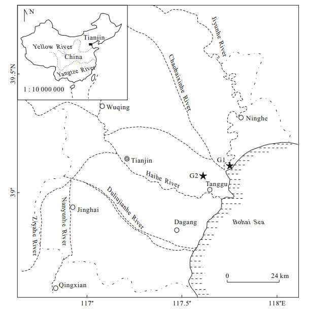
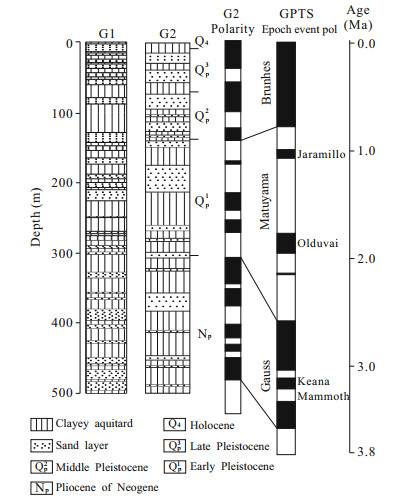
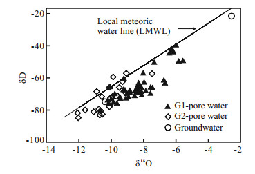
The record of paleo-environment in clayey aquitard pore water is much more effective relative to aquifer groundwater owing to the low permeability of clayey aquitard. Oxygen-18 (18O), deuterium (D), and chemical patterns were determined in pore water samples extracted from two 500 m depth boreholes, G1 and G2, in western Bohai Bay, China. Shallow pore water samples (depth < 102 m) are saline water, with the TDS (total dissolved solids) of 3.69–30.75 g/L, and deeper ones (depth=102–500 m) are fresh water, with the TDS < 1 g/L. Content of major ions (i.e., Cl, Na+, K+, Mg2+, SO42−, Ca2+) is high in marine sediment pore water samples and gradually decrease towards to terrestrial sediment pore water, together with the Cl/Br and Sr/Ba ratios changing significantly in different sedimentary facies along the study profile, indicating that pore water may be paleo-sedimentary water and not replaced by modern water. δ18O profile and positive correlation between δ18O and Cl of shallow saline pore water indicated diffusion as the main transport mechanism, and distinguished four transgressive layers since Late Quaternary (i.e., Holocene marine unit, two Late Pleistocene marine units and Middle Pleistocene marine unit), further supporting the finding that pore water retained the feature of paleo-sedimentary water. Climate was identified as the main influence on the isotopic signature of aquitard pore water and four climate periods were determined by δ18O profile.
Influence of rain on tetrachloroethylene's multiphase migration in soil
Yong Qian, Jingli Shao, Zhaoji Zhang, Yuhong Fei, Chunxiao Wang, Xiangxiang Cui, Suhua Meng
2015, 26(3): 453-460. doi: 10.1007/s12583-015-0547-6
Abstract:
For the increasingly serious soil and groundwater pollution by volatile organic compounds, tetrachloroethylene (PCE) was selected as the research object in this study. With the in-situ soil column physical simulation experiments, migration law of PCE in soil under rain conditions was studied by monitoring precipitation and soil parameter as well as sampling and analyzing soil and soil gas, and influence of rain on the multiphase migration process of PCE was preliminarily discussed. Research shows that migrations of PCE and soil moisture were not synchronous, and the rate of the former was speeded up by the latter caused by rain. Preliminary analysis indicates that migration of volatile chlorohydrocarbon in soil was not only driven by soil moisture, but also controlled by the nature of volatility of their own, that is to say, volatilization into gas phase was an important way of migrating and diffusing in pore medium, and the rate of migration and diffusion of gaseous PCE was faster than that of solid, resulting in more abroad distribution of gas phase than that in solid phase.