Advanced Search

Indexed by SCI、CA、РЖ、PA、CSA、ZR、etc .

2000 Vol. 11, No. 4

Display Method:
 
Genetic Types of Meter-Scale Cyclic Sequences and Fabric Natures of Facies Succession
Mingxiang Met, Debin Xu, Hongrui Zhou
2000, 11(4): 375-382.
Abstract:

Different genetic types of meter-scale cyclic sequences in stratigraphic records result from episodic accumulation of strata related to Milankovitch cycles. The distinctive fabric natures of facies succession result from the sedimentation governed by different sediment sources and sedimentary dynamic conditions in different paleogeographical backgrounds, corresponding to high-frequency sea-level changes. Naturally, this is the fundamental criterion for the classification of genetic types of meter-scale cyclic sequences. The widespread development in stratigraphic records and the regular vertical stacking patterns in long-term sequences, the evolution characters of earth history and the genetic types reflected by specific fabric natures of facies successions in different paleogeographical settings, all that show meter-scale cyclic sequences are not only the elementary working units in stratigraphy and sedimentology, but also the replenishment and extension of parasequence of sequence stratigraphy. Two genetic kinds of facies succession for meter-scale cyclic sequence in neritic-facies strata of carbonate and clastic rocks, are normal grading succession mainly formed by tidal sedimentation and inverse grading succession chiefly made by wave sedimentation, and both of them constitute generally shallowing upward succession, the thickness of which ranges from several tens of centimeters to several meters. The classification of genetic types of meter-scale cyclic sequence could be made in terms of the fabric natures of facies succession, and carbonate meter-scale cyclic sequences could be divided into four types: L-M type, deep-water asymmetrical type, subtidal type and peritidal type. Clastic meter-scale cyclic sequences could be grouped into two types: tidal-dynamic type and wave-dynamic type. The boundaries of meter-scale cyclic sequences are marked by instantaneous punctuated surface formed by non-deposition resulting from high-frequency level changes, which include instantaneous exposed punctuated surface, drowned punctuated surface as well as their relative surface. The development of instantaneous punctuated surface used as the boundary of meter-scale cyclic sequence brings about the limitations of Walter's Law on the explanation of facies distribution in time and space, and reaffirm the importance of Sander's Rule on analysis of stratigraphic records. These non-continuous surface could be traced for long distance and some could be correlative within same basin range. The study of meter-scale cyclic sequences and their regularly vertical stacking patterns in long-term sequences indicate that the research into cyclicity of stratigraphic records is a useful way to get more regularity from stratigraphic records that are frequently complex as well as non-integrated.

Tectonometamorphic Cycles in Different Geodynamic Conditions
V Miller Yu, M S Dufour
2000, 11(4): 383-391.
Abstract:

Formation and attenuation of crust thermal anomalies, accompanied by development of geological structures, are governed by special laws, together with metamorphism and other endogenic process, form tectonometamorphic cycle (TMC). Because of rock rheology under metamorphic conditions, the structures, concurring with metamorphism, reflect geodynamic conditions much more perfect than those of the structures of nonmetamorphosed rocks. For this reason, structural investigations open wide, sometimes unique, possibilities for geodynamic research into regional metamorphosed terrains. The TMC features under different geodynamic conditions are shown with examples of California (subduction), Himalaya and Junggar Alatau (collision), and Northwest environs of the White Sea (polycyclic development). The analysis of these units serves as basis of some general conclusions. TMC, the steady pattern of crust thermal anomalies manifestation, does not practically depend on peculiarities of metamorphism. At lower and middle crust levels, occur the high-temperature complete cycles that include following two stages. The first is represented by nappes and paragenes of parallel bedding flow, the second, by linear folds, domes and faults. At top levels of fold complexes display the low-temperature reduced cycles, expressed only by structures of the second stage. There are gradual transitions between the complete and reduced cycles. Thermal anomalies in the first stage of complete cycles devolop against the background of large horizontal displacements at contacts between interacting plates or are genetically connected with their gently sloping fault planes. Of all structural elements of the cycles, in compressional environments (nappes, linear folds, domes etc.), only the structures of the first stage of complete cycles can be considered as indications of plate tectonics. Presence of such structures at the most ancient supracrustal complexes point to existence of plate tectonics already at the early stages of geological development of the earth.

Geochemistry of Gneisses from Dabie Complex and Tongbai Complex in Qinling-Tongbai-Dabie Orogenic Belt: Implications for Location of Yangtze-Sino-Korean Suture
Hongfei Zhang, Benren Zhang, Zengqiu Zhong, Shan Gao, Shenghong Hu
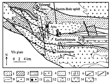
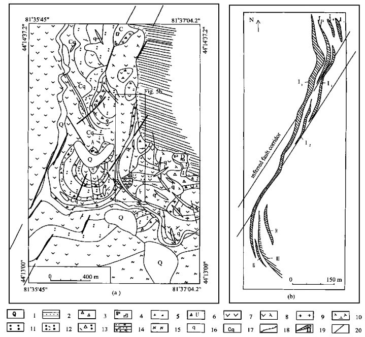
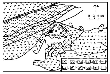
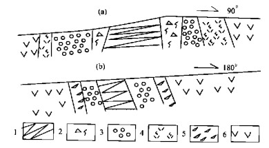
2000, 11(4): 392-405.
Abstract:

The Dabie complex(DC)and the Tongbai complex(TBC)are separately distributed in the middle and eastern parts of the Qinling-Tongbai-Dabie orogenic belt. In this study, the Dabie complex can be divided into two units: one is the complex with no high pressure and ultrahigh pressure metamorphic rocks(DC1), and the other is the complex containing coesite-bearing eclogite lenses or boudins(DC2). Gneisses are predominant in the TBC, DC1 and DC2. Major and trace element data of gneisses in the TBC, DC1 and DC2 show them to be the orthogneisses. The gneisses in the DC1 have higher incompatible element contents and higher ratios of w(K2O)/ w(Na2O)and w(La)n/ w(Yb)nthan those in the DC2. However, no obvious differences arise in other element contents and the ratios of w(La)/w(Nb), w(Nb)/ w(Th), w(Nb)/w(Hf), w(Ba)/w(La), w(Sm)/w(Nd)and w(Th)/w(U)between the gneisses in the DC2 and those in the DC1. These observations suggest that the protoliths of the gneisses in the DC2 have affinities to those in the DC1. The difference between the DC1 and DC2 gneisses in incompatible element contents could reflect the difference in their partial melting extent. The TBC gneisses are geochemically similar to the DC1 gneisses, suggesting that the TBC and DC1 gneisses are the same lithologic unit in the Qinling-Tongbai-Dabie orogenic belt and that they have experienced similar formations and evolution histories. In the Qinling-Tongbai area, the TBC is part of the northern blocks of the Yangtze craton. Given the similarity of geochemical characteristics, the rock assemblage and the ages between the TBC and DC1 gneisses, we can infer that the Dabie complex also belongs to the northern blocks of the Yangtze craton. In terms of the distribution of eclogites and metamorphic facies, we propose that the collisional suture in the Dabie area is distributed along the Xiaotian-Mozitan fault, at the contact with the Shang-Dan-Tongbai fault to the west.

Determination of Salinity in Fluid Inclusions with Laser Raman Spectroscopy Technique
Javad Moghaddasi Seyed, Shuzhen Yao, Xinbiao Lü
2000, 11(4): 406-409.
Abstract:

A preliminary study was conducted to outline the laser Raman spectroscopy technique for determination of salinity in the aqueous phase in fluid inclusions. The skewing parameters of the Raman profiles of the calibration solutions determined were used to derive a calibration curve for the estimation of the equivalent mass fraction NaCl in aqueous solutions. This technique was also verified in the analysis of the natural fluid inclusions from Tongshankou porphyry Cu(Mo)deposit, Hubei Province, China. Although the analyses on the natural fluid inclusions are limited, an acceptable agreement has been reached on the salinities, for most fluid inclusions, determined by the Raman spectroscopy and microthermometry techniques, indicating the reliability of the Raman technique for determination of salinity in fluid inclusion studies.

Epithermal Gold Mineralization in Chinese Tianshan Province
Long Xiao, Fangzheng Wang
2000, 11(4): 410-415.
Abstract:

Tianshan is a part of the complex system of orogenic belts of Phanerozoic in Central Asia. In the northwestern Chinese Tianshan, Borohoro range, the major metallogenic belt in this area is situated between the Yili block and Keguqinshan-Sairim uplift. The intra-arc basins resulting from southward subduction of the Junggar plate and accompanying volcanism are the essential factors for the formation of the hydrothermal system that caused gold mineralization. The adularia-sericite-style epithermal Arxi gold deposit formed in an extensional tectonic setting. In the eastern Tianshan, post-orogenic magmatism resulted in a hydrothermal system that produced the epithermal Xitan gold deposit. Both gold deposits are related to local extensional setting, although differences exist in their timing and location.

Darcy's Law Expressed by Chemical Index
Kuanrong Hu, Yuqing Cao, Wenbing Zhang, Zhongyi Hu
2000, 11(4): 416-421.
Abstract:

The Darcy's formula expressed by chemical indexes (ion activity a and saturation index β) is derived with the aid of the kinetics of multi-mineral dissolution. The implication of the formula and the relationship between the formula and the original Darcy's law expressed by hydraulic index (hydraulic gradient, Ⅰ) are discussed here. An analytic expression is established in this paper for the determination of the residence time of groundwater by chemical indexes, whose equivalence to isotopic age is studied. The formulas are derived from the calculation of permeability coefficient (K), conductivity coefficient (T) and actual velocity of groundwater (U). Finally, this paper introduces hydrogeological chemical kinetics constant (kj) and its determination method, differential and integral equations for chemical kinetics of groundwater in three-dimensional space.

Indirect Indicators of Gas Hydrate Occurrence within Submarine Sediments
Xingmin Zhao, Bihao Wu, Yaping Wang, Zhenquan Lu
2000, 11(4): 422-425.
Abstract:

Gas hydrate, a new kind energy resources discoverd over the past ten years, has aroused much attention from many countries around the globe, because the gas hydrate has played a very important role in energy resources exploration, submarine geohazards precaution, and changes in global climate. So far, gas hydrates have been found in about sixty places on continental margins and polar regions in the world, but the majority of them is recognized by all kinds of indirect indicators owing to their limited existence conditions, only minority of them is collected. Thereby, the indirect marks of gas hydrates play an important role in exploration of the clathrate compounds, and the authors discuss them.

Flow Deflection in Intersected Tubes
Kaiming Tian, Li Wan
2000, 11(4): 426-428.
Abstract:

In order to verify the flow interference at the fracture intersections, a group of hydraulic simulations of crossing flow was carried out. The manifold interference effects at the intersection of fractures on water flow has been confirmed extensively either in the normal or in the oblique intersected tubes as well as in the intersected tubes of either equal or variant diameters. Consequently, suggest that the fissure network can no longer be taken as a set of solitary fractures, but as a set of elementary intersected fractures. The deflection effect at fracture intersections on the water flow should be taken into consideration when is dealt with any theory related to the water migration in fractures.

Urban Geological Environment and Land-Utilization Evaluation in Xi'an
Xianzhong Li
2000, 11(4): 429-432.
Abstract:

In this paper, the urban geosciences with the geological environment of Xi' an as an example are studied in detail. A corresponding model is employed to make a comprehensive evaluation of the landuse capacity, providing a scientific base for the controlling measures of the urban land-use project.