Advanced Search

Indexed by SCI、CA、РЖ、PA、CSA、ZR、etc .

2011 Vol. 22, No. 4

Display Method:
Research
Mechanisms and Simulation of Accelerated Shrinkage of Continental Glaciers: A Case Study of Urumqi Glacier No. 1 in Eastern Tianshan, Central Asia
Zhongqin Li, Huilin Li, Yaning CHEN
2011, 22(4): 423-430. doi: 10.1007/s12583-011-0194-5
Abstract:
Similar to most mountain glaciers in the world, Urumqi Glacier No. 1 (UG1), the best observed glacier in China with continued glaciological and climatological monitoring records of longer than 50 years has experienced an accelerated recession during the past several decades. The purpose of this study is to investigate the acceleration of recession. By taking UG1 as an example, we analyze the generic mechanisms of acceleration of shrinkage of continental mountain glaciers. The results indicate that the acceleration of mass loss of UG1 commenced first in 1985 and second in 1996 and that the latter was more vigorous. The air temperature rises during melting season, the ice temperature augment of the glacier and the albedo reduction on the glacier surface are considered responsible for the accelerated recession. In addition, the simulations of the accelerated shrinkage of UG1 are introduced in this article.
Microscopic Analyses of Insoluble Particles in an Ice Core of Ürümqi Glacier No. 1: Quantification of Mineral and Organic Particles
Nozomu Takeuchi, Yoriko Ishida, Zhongqin Li
2011, 22(4): 431-440. doi: 10.1007/s12583-011-0197-2
Abstract:
Insoluble particle concentration in ice cores is commonly analyzed as a proxy for variations in atmospheric mineral dust (aerosol concentration). However, recent studies have revealed that the mineral dust is not only a constituent of the particles but that biogenic organic particles are also contained. We microscopically analyzed insoluble particles in a shallow ice core drilled on a mountain glacier, the Ürümqi Glacier No. 1, in eastern Tienshan, China. We distinguished different morphological particles in the ice core and quantified them separately. Results showed that the insoluble particles in this ice core consisted mainly of mineral particles, amorphous organic particles, pollen, and microorganisms. Mineral particles were the most dominant, accounting for approximately 67% of total particles, and amorphous organic particles were the second most dominant, accounting for approximately 33% of the total. The annual variation in the particles for the last 11 years differed between mineral and amorphous organic particles. The results suggest that the total insoluble particle concentration in the ice core reflects not only the atmospheric mineral dust but also the organic particles blown from ground soil or produced by microbes on the glacial surface.
An Improved Method Based on Shallow Ice Approximation to Calculate Ice Thickness along Flow-Line and Volume of Mountain Glaciers
Huilin Li, Zhongqin Li, Mingjun Zhang, Wenfeng Li
2011, 22(4): 441-448. doi: 10.1007/s12583-011-0198-1
Abstract:
To evaluate the water storage and project the future evolution of glaciers, the ice-thickness of glaciers is an essential input. However, direct measurements of ice thickness are laborious, not feasible everywhere, and necessarily restricted to a small number of glaciers. In this article, we develop a simple method to estimate the ice-thickness along flow-line of mountain glaciers. Different from the traditional method based on shallow ice approximation (SIA), which gives a relationship between ice thickness, surface slope, and yield stress of glaciers, the improved method considers and presents a simple way to calibrate the influence of valley wall on ice discharge. The required inputs are the glacier surface topography and outlines. This shows the potential of the method for estimating the ice-thickness distribution and volume of glaciers without using of direct thickness measurements.
Selected Trace Elements in Snowpack on Urumqi Glacier No. 1, Eastern Tianshan, China: As Yielded by Leaching Treatment Representative of Real-World Environmental Conditions
Mingjun Zhang, Shengjie Wang, Feiteng Wang, Yuefang Li
2011, 22(4): 449-459. doi: 10.1007/s12583-011-0199-0
Abstract:
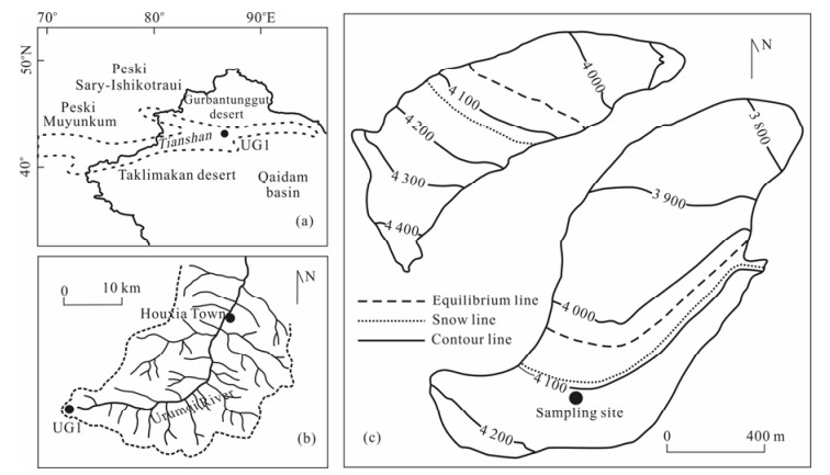
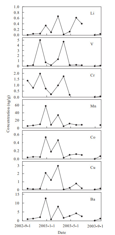
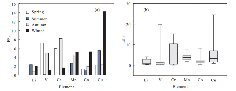
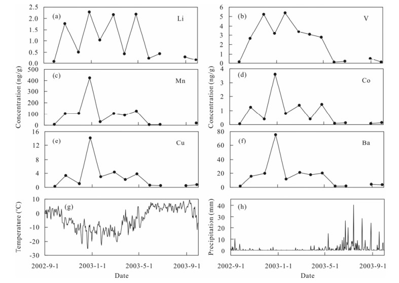
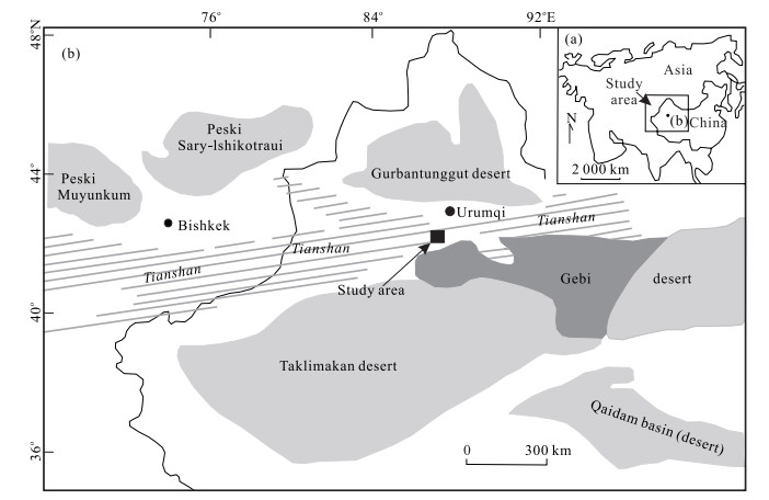
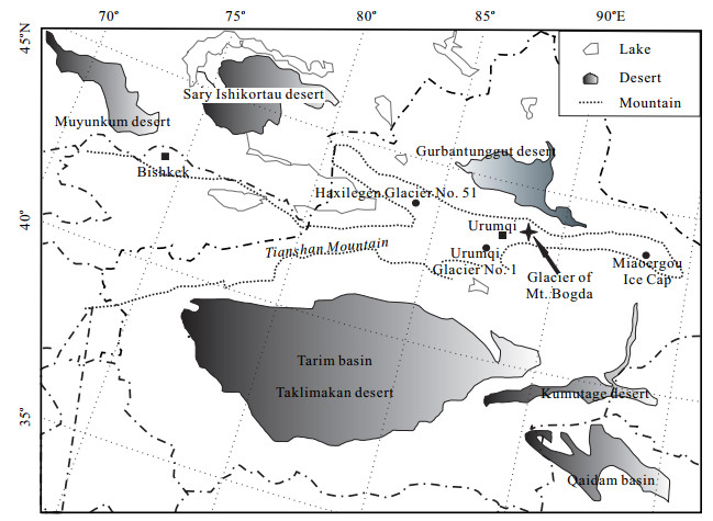
To investigate the seasonal variability and potential environmental significance of trace elements in mountain glaciers, the surface snow and snow pit samples were collected at Urumqi Glacier No. 1 (43°06′N, 86°49′E, 4 130 m a.s.l.), eastern Tianshan (天山), from September 2002 to September 2003, and analyzed for Li, V, Cr, Mn, Co, Cu, and Ba. The samples were acidified (leached) in a manner intended to reasonably approximate the extent to which the natural hydrologic and weathering cycles would liberate elements from mineral grains (dusts) in the ice and snow into the environment. The mean concentrations of Li, V, Cr, Mn, Co, Cu, and Ba are 0.2, 1.1, 0.8, 14.8, 0.1, 0.7, and 3.2 ng/g in surface snow but 1.0, 2.2, 1.8, 92.4, 0.8, 2.9, and 16.2 ng/g in snow pits, respectively. Input varies seasonally: in general, concentrations in the winter are higher than those in the summer. The trace elements are somewhat enriched (relative to expected abundances in material taken directly from the earth's crust) and similar to what is observed in both pre-industrial and modern atmospheric dusts, although some anthropogenic components from nearby industrial cities may be present. Concentration vertical profiles can be redistributed in the post-depositional process, which may cause loss of trace elements in the summer.
Deposition Process of Dust Microparticles from Aerosol to Snow-Firn Pack on Glacier No. 1 in Eastern Tianshan Mountains, China
Xiaoni YOU, Zhiwen DONG
2011, 22(4): 460-469. doi: 10.1007/s12583-011-0200-y
Abstract:
Samples were continuously collected from aerosol, fresh snow, and snow pits on Glacier No. 1 at Urumqi River source in eastern Tianshan (天山) Mountains. The deposition processes and the characteristics of mineral dust microparticles from aerosol to fresh snow, and then evolution to the snow pit were determined. Total dust microparticle concentration in the surface snow and aerosol showed a similar temporal variation trend, which was strongly associated with regional and local atmospheric circulation in the Tianshan Mountains region of Central Asia. Especially from November to February, the correlation coefficient of microparticles concentration in surface snow and aerosol is very high (R 2=0.7). Vertical profiles of microparticles in the snow pits showed that observed dust layers were in high correlation with concentration peaks of large microparticles (d > 10 μm), but low correlation with that of fine microparticles (d < 1 μm). Moreover, explicit post-depositional process of dust particles was studied by tracking some typical dust concentration peaks in the snow pit. We find that late summer is a key period for post-deposition of dust particles in the snow, as particle concentration peaks in the snow pit evolve intensely during this period. Such evolutional pattern of large particles makes it possible to preserve information of atmospheric dust in the snow, which offers an available proof to reconstruct historical climate using ice cores on Glacier No. 1 and other glaciers in the Tianshan Mountains.
Application of a Degree-Day Model for Determination of Mass Balance of Urumqi Glacier No. 1, Eastern Tianshan, China
Lihua Wu, Huilin Li, Lin Wang
2011, 22(4): 470-481. doi: 10.1007/s12583-011-0201-x
Abstract:
In order to verify the feasibility and stability of a degree-day model on simulating the long time series of glacier mass balance, we apply a degree-day model to simulate the mass balance of Urumqi Glacier No. 1 for the period 1987/1988–2007/2008 based on temperature and precipitation data from a nearby climate station. The model is calibrated by simulating point measurements of mass balance, mass balance profiles, and mean specific mass balance during 1987/1988–1996/1997. The optimized parameters are obtained by using a least square method to make the model fit the measured mass balance through the model calibration. The model validation (1997/1998–2007/2008) indicates that the modeled results are in good agreement with the observations. The static mass balance sensitivity of Urumqi Glacier No. 1 is analyzed by computing the mass balance of the glacier for a temperature increase of 1 ℃, with and without a 5% precipitation increase, and the values for the east branch are −0.80 and −0.87 m w.e. a−1·℃−1, respectively, and for the west branch, the values are −0.68 and −0.74 m w.e. a−1·℃−1, respectively. Moreover, the analysis of the parameter stability indicates that the parameters in the model determined from the current climate condition can be applied in the prediction of the future mass balance changes for the glacier and provide a reference for extending the model to other small glaciers in western China.
Chemical Characteristics of Snow-Firn Pack in Altai Mountains and Its Environmental Significance
Feiteng Wang, Lin Wang, Jian Kang, Futang Kou
2011, 22(4): 482-489. doi: 10.1007/s12583-011-0202-9
Abstract:
In order to study the chemical characteristics of snow-firn pack in Altai Mountains and its environmental significance, a 1.5-m deep snow-firn pack was dug in the accumulation zone (3 300 m a.s.l.) of the Kanas Glacier in August 2009. A total of 15 samples were analyzed for major ions. Results show that the concentrations of major ions in the snow-firn pack are NH4+ > SO42− > Ca2+ > NO3 > Na+ > Cl > K+ > Mg2+. NH4+ is the dominant cation with a medium value of 4.7 ueq·L−1, accounting for 39.8% of the total cations, and SO42− is the dominant anion, with a medium value of 4.0 ueq·L−1, which accounts for 33.9% of the total cations. Compared with Belukha Glacier (Altai), Urumqi Glacier No. 1, and the Inilchek Glacier (Tienshan), there is a lower ion concentrations in the Kanas snow-firn pack. Potential sources of these chemical species are explored using correlation and empirical orthogonal function (EOF) analyses. The analyses indicate that major ion concentrations (except NH4+) originate from crustal dust. Backward trajectory analysis was applied to get the origin of the air mass to Kanas Glacier. The results suggest that air pollutants emitted by forest fires in Siberia could be transported and influence the NH4+, NO3, and SO42− concentrations on the Kanas Glacier.
Anthropogenic Sulfate and Nitrate Signals in Snow from Bogda Glacier, Eastern Tianshan
Xiaoyu Zhang, Ross Edwards
2011, 22(4): 490-502. doi: 10.1007/s12583-011-0196-3
Abstract:
A 1.2 m snow pit was recovered on July 29th, 2009 from the Bogda Glacier, eastern Tianshan (天山). The sample site temperature of −9.6 ℃ indicates that the unique glaciochemical record was well preserved and suitable for the reconstruction of air pollution levels in this previously unexplored region. Samples were analyzed for major ions (Na+, K+, Ca2+, Mg2+, NH4+, Cl, SO42−, NO3, HCOO, and CH3COO). NO3 and SO42− were characterized by significant high levels of pollution concentration. Most air masses backward trajectories ending in December 2008 have passed the Urumqi City center, while some even traveled across the primary nuclear weapons testing venue of the former Soviet Union (STS). The mean pH value of snow samples is coincident with the average value of Urumqi's aerosol, and the ratio of [NO3]/[SO42−] in the snow pit generally agrees with the value of the Urumqi winter aerosols. In addition, the [HCOO]/[CH3COO] ratio of snow samples is only 0.7, lower than unity. These analyses indicate that SO42− and NO3 in the Bogda Glacier are the result of anthropogenic pollutions.
Monitoring Glacial Shrinkage Using Remote Sensing and Site-Observation Method on Southern Slope of Kalik Mountain, Eastern Tian Shan, China
Wenbin Wang, Kaiming Li, Jianfang Gao
2011, 22(4): 503-514. doi: 10.1007/s12583-011-0203-8
Abstract:
Currently, one of the effective means in monitoring glacier change in regional scale is remote sensing and site-observation method. In this article, we present a study of comparing glacier area in 2005 derived from SPOT5 satellite image with area in 1972 derived from topographic maps. Moreover, Miaoergou (庙儿沟) flat-summit glacier is site observed to verify glacial change in regional scale. During the study period, glaciers located in the southern slope of Kalik (喀尔里克) Mountain reduced their area by 12.3%. The high individual change indicates that the wastage corresponding to area changes has been the dominant process of glacier mass loss in this region. Glaciers smaller than the mean size (1.3 km2), especially those < 0.5 km 2, lost more of their area with high variability and yielding two glaciers vanished. It is suggested that small glaciers are prone to disappear under such climate conditions in future years. With the difference supplied by upstream glaciers, there appears great disparity trend of river runoff recently. Seen from decade-scale, the discharge, the lower glacier-covered catchment, is decreased because of strong consumption of small glaciers during the past decades. Owing to the rivers that are supplied by more meltwater from medium and larger glaciers mainly, the trend of the river runoff increase is still going on. Trends of river runoff of three different glacier-covered catchments exhibit distinctive results. This implies that retreating glaciers will reduce the ability to regulate the water circulation.
On the Relationship between Local Topography and Small Glacier Change under Climatic Warming on Mt. Bogda, Eastern Tian Shan, China
Kaiming Li, Huilin Li, Lin Wang, Wenyu Gao
2011, 22(4): 515-527. doi: 10.1007/s12583-011-0204-7
Abstract:
Glacial features in the geological record provide essential clues about past behavior of climate. Of the numerous physical systems on earth, glaciers are one of most responsive to climate change, especially small glaciers, their direct marginal response taking only a few years or decades to be expressed. Accelerating recession of modern glaciers raises the issue of the climate's impact on water runoff. Data based on topographic maps and Advanced Spaceborne Thermal Emission and Radiometer (ASTER) imagery show the trends that are highly variable over time and within the region. An analysis of the local topographic settings of very small (< 0.5 km2) glaciers was conducted to investigate their influence on recent changes in these glaciers. Among 137 glaciers, 12 disappeared completely. The study reveals that glaciers situated in favorable locations had tiny relative area reduction, while those in less favorable settings generally had large area loss or even disappeared. It is suggested that most of the small glaciers studied have retreated as far as they are likely to under the climatic conditions of the late 20th century. Undoubtedly, the strong retreating of small glaciers exerts adverse effects on the hydrologic cycle and local socioeconomic development.
Spatial Distribution of the Debris Layer on Glaciers of the Tuomuer Peak, Western Tian Shan
Lin Wang, Zhongqin Li, Feiteng Wang
2011, 22(4): 528-538. doi: 10.1007/s12583-011-0205-6
Abstract:
This article, based on the field work took place on the zone of Tuomuer (托木尔) Peak, western Tian Shan (天山) during the period May 2008 to September 2009, obtained the spatial distribution of debris layer on the reference glaciers (Glacier No. 72, Glacier No. 74, Tuomuer Glacier) by detailed measurements of debris thickness and ablation rates on glacier and further by Spot-5 (5 m, 2005) high-resolution satellitic image applying remote sensing and geographic information systems approach to research the spatial distribution of debris layer on the zone of Tuomuer Peak. Specifically, the results indicate a sharp in ablation with debris cover thickness increasing from 0–4 cm followed by a decrease in ablation with debris thickness increasing beyond 4 cm for the glaciers No. 72 and No. 74. Spatial distributions of debris layer on the three reference glaciers have the same characteristics, the overall distribution from the vertical, the maximum thickness of debris in the glacier terminal, and the thickness of debris is constantly thinning since the end of the glacier increases with altitude. For the overall distribution from the horizontal, the regular pattern of debris thickness from both sides to the middle is diminishing. The debris on the zone of Tuomuer Peak mostly covered the glacier tongue and is mainly distributed below the altitude of 4 000 m; the area of debris covered approximate accounted for 14.9% on the entire glacier area in this region. Spatial distribution of debris layer on the zone of Tuomuer Peak is mainly affected by the elevation of the glacier terminal, followed by the slopes orientation, the sizes, and so on.
Rapid Shrinking of Glaciers in the Middle Qilian Mountain Region of Northwest China during the Last ~50 Years
Puyu Wang, Zhongqin Li, Wenyu Gao
2011, 22(4): 539-548. doi: 10.1007/s12583-011-0195-4
Abstract:
During the past five decades, fluctuations of glaciers were reconstructed from historical documents, aerial photographs, and remote sensing data. From 1956 to 2003, 910 glaciers investigated had reduced in area by 21.7% of the 1956 value, with a mean reduction for the individual glacier of 0.10 km2. The relative area reductions of small glaciers were usually higher than those of large ones, which exhibited larger absolute loss, indicating that the small glaciers were more sensitive to climate change than large ones. Over the past ~50 years, glacier area decreased by 29.6% in the Heihe (黑河) River basin and 18.7% in the Beidahe (北大河) River basin, which were the two regions investigated in the Middle Qilian (祁连) Mountain region. Compared with other areas of the Qilian Mountain region, the most dramatic glacier shrinkage had occurred in the Middle Qilian Mountain region, mainly resulting from rapid rising temperatures. Regional differences in glacier area changes are related to local climate conditions, the relative proportion of glaciers in different size classes, and other factors.