Advanced Search

Indexed by SCI、CA、РЖ、PA、CSA、ZR、etc .

2011 Vol. 22, No. 3

Display Method:
Research
Tectonics and Mechanisms of Uplift in the Central Uplift Belt of the Huimin Depression
Jinlong Ni, Ying Guo, Zhimin Wang, Junlai Liu, Yuxiang Lin, Yue Li
2011, 22(3): 299-315. doi: 10.1007/s12583-011-0183-8
Abstract:
The Huimin (惠民) depression is a third-level tectonic element of the Bohai (渤海) Bay basin in eastern China. The central uplift belt is the most important oil and gas accumulation zone in the depression, but the lack of adequate geological studies in the area has greatly hindered exploration and development. In this article, using seismic data, fracture mechanics, and a combination of data on fault growth indices and fault throws, we present an analysis of tectonic activity in the central uplift belt and adjacent regions. The amount of extension is calculated along balanced N-S cross-sections, along with the thickness of strata eroded from the fourth, third, and second members of the Shahejie (沙河街) Formation (Es4-Es2) in the uplift belt, by analyzing porosity and stratigraphic correlations. In addition, uplift features are described, and their timing and processes of formation are analyzed and discussed. The results indicate that strike-slip and extensional tectonic movements coexisted, with the effects of the latter most obvious. The spatial and temporal nature of the extensional movements is varied: fault activity during the period Ek-Es4 was the strongest on the northern Ningnan (宁南) fault, and activity in the western part of the area was stronger than that in the east, which in turn was stronger than that in the central region; during Es3-Es2, the strongest fault movements were along the eastern part of the middle Linyi (临邑) fault, and activity in the western part of the area was relatively weak, whereas in the mid-west it was the strongest. The extensional movements were a response to the activity of the faults. The sediments in the lower part of the fourth member of the Shahejie Formation (Es4 x) show that Es4 was the time when the central belt first began to be uplifted strongly. Uplift was uneven during the Paleogene: the western part of the area was uplifted continuously, while the mid-eastern area underwent alternating periods of uplift and subsidence. During the Paleogene, a number of different tectonic features developed in the central uplift belt at different times and are manifested as follows: during the period Ek-Es4, a gentle slope was formed as part of the Zizhen (滋镇) sag; during Es3-Es2, the northern part of the central uplift belt continued to display a gentle slope as part of the Zizhen sag, but the southern region developed an steep slope as part of the Linnan (临南) sag. There are close interrelationships between uplift, strike-slip, and extension within the central uplift belt of the Huimin depression, as is manifest by the areas of strongest extension being uplifted most rapidly, and also eroded the most.
Two Types of Strike-slip and Transtensional Intrabasinal Structures Controlling Sandbodies in Yitong Graben
Jiahao Wang, Honghan Chen, Hua Wang, Tao Jiang, Hongbo Miao
2011, 22(3): 316-325. doi: 10.1007/s12583-011-0184-7
Abstract:
Recently, the researches on structure controls on sandbodies have provided a new method for predicting petroleum reservoirs. The Yitong (伊通) graben is situated in the northern section of the Tan-Lu (郯-庐) fault system in eastern China. It was characterized by dual properties of strike-slip and extension in Cenozoic. Two types of intrabasinal structures were identified as oblique fault and transverse uplift in the graben. The oblique faults arranged en echelon in plain and locally presented negative rosette structures on seismic profile, so they were closely derived from strike-slip movement of the northwestern boundary faults. Moreover, these oblique faults were divided to five zones. The three transverse uplifts, located corresponding to flattened southeast boundary faults, were mainly originated by displacement-gradient folding due to segmental extensional activities of southeast boundary faults. The large-scale sandbodies of subaqueous fan facies and fan delta facies had developed at the two types of intrabasinal structure zone. Based on analyzing the seismic facies, logging facies and seismic attribute extractions, and on discovering many incised valleys at the oblique fault zones, the two types of intrabasinal structures were revealed to have conducted drainage entering basin and further dispersing, and to have consequently controlled the development and distribution of sandbodies.
Formation Mechanism of High Quality Marine Source Rocks—Coupled Control Mechanism of Geological Environment and Organism Evolution
Tenger, Kai Hu, Qingqiang Meng, Juan Huang, Xiaodong FU, Xiaomin Xie, Yunfeng Yang, Changlin Gao
2011, 22(3): 326-339. doi: 10.1007/s12583-011-0185-6
Abstract:
High quality marine source rock (HQMSR) is the key prerequisite for medium to large hydrocarbon accumulations. However, the forming mechanism remains unclear. On the basis of the investigation for the geodynamic setting of the Middle-Upper Yangtze during the Early Cambrian in different spatial scales and the analysis of trace elements, the main controlling factors of the development of high quality marine source rock are discussed, with specific consideration of the burial rate of the organic matter. The formation of high quality marine source rocks is suggested to be the result of a coordinated development and the interaction between geological environments and organism evolution during the major geological transition periods. We perceived that the burial rate of organic matter was influenced by the primary productivity and its burial conditions. The abundance of autogenetic molybdenum gained directly by the chemical speciation analysis of rocks could be used as a proxy for the burial organic matter. The burial rate of autogenetic molybdenum and the sedimentary organics in modern marine environments could be used to estimate the sedimentary organics in ancient environments effectively.
Hybrid Sedimentation in Late Permian-Early Triassic in Western Sichuan Basin, China
Shengxiang Long, Shixiang Wu, Hongtao Li, Zhenrui Bai, Jinyu Ma, Hua Zhang
2011, 22(3): 340-350. doi: 10.1007/s12583-011-0186-5
Abstract:
Mixed carbonate-siliciclastic sedimentation is common in the Upper Permian-Lower Triassic in the western Sichuan (四川) basin. The extensional movement was strong in the Late Permian, resulting in differential uplifting of fault blocks. During this period, there was an extensive retrogression. The Kangdian (康滇) ancient land progressive uplifted and enlarged, forming the major provenance of terrigenous clastics. In Changxingian age, mixed terrigenous-carbonate sedimentation was distributed in the area between Dafeishui (大飞水)-well Dashen (大深)-1-well Shoubao (寿保)-1 and Beichuan (北川)-well Guanji (关基). The terrigenous clastics sourced from Kangdian ancient land input into the relatively shallow water, resulting in an extensive limited platform-mixing tidal flat where moderate-thick laminated grey limestone, thin muddy limestone and purplish red sandy shale were deposited. The tectonic framework in Feixianguanian (飞仙关) stage was inherited from the Changxingian stage. The hybrid sedimentation was limited to the south of Dujiangyan (都江堰)-Xindu (新都). In Jialingjiangian (嘉陵江) stage, the palaeogeographic features were also unchanged and two complete transgression-retrogression cycles also occurred. The mixing tidal flat was distributed to the west of Baoxing (保兴)-Ya'an (雅安)-Hongya (洪雅)-Leshan (乐山), where purplish red sandstone with thin limestone and shale interbeds and grey-dark grey silty mudstone with limestone were deposited. The carbonates in the mixed facies tract have few primary pores preserved and poorly-developed secondary pores due to the relatively high content of terrigenous clastics, strong compaction and weak dissolution. Therefore, they are unfavorable for the development of effective reservoirs.
Pressure Evolution and Hydrocarbon Migration-Accumulation in the Moliqing Fault Depression, Yitong Basin, Northeast China
Qiang Cao, Jiaren Ye, Hairuo Qing, Junze Lu, Shengbing Huang, Daqing Tang
2011, 22(3): 351-362. doi: 10.1007/s12583-011-0187-4
Abstract:
The Yitong (伊通) basin is a Late Mesozoic and Cenozoic continental sedimentary basin in Northeast China. On the basis of well tests and seismic data, we use the 2D modeling technique to rebuild the pressure evolution and hydrocarbon migration in the Moliqing (莫里青) fault depression of the Yitong basin. Based on the modeling results, four conclusions are drawn as follows. (1) The Eocene Shuangyang (双阳) Formation within the Moliqing fault depression had entirely undergone three episodic cycles of pressure accumulation and release in geological history, and the three tectonic movements since the Middle Eocene played important roles in the episodic changes of excess pressure. (2) The present formation pressure distribution is characterized by normal pressure in almost the entire fault depression with some residual overpressure. The differential distribution of pressure results mainly from the difference in rock facies, sedimentation rate, hydrocarbon generation, and fault activities. (3) The hydrocarbon migration is more active during the release of pressure in the Moliqing fault depression, which happened mainly in the Middle-Late Oligocene and provided the driving force for hydrocarbon migration. (4) The hydrocarbon migration was mostly directed to the Shuangyang Formation within the Jianshan (尖山) uplift and the Kaoshan (靠山) sag. With the superior condition of hydrocarbon accumulation and the higher degree of hydrocarbon concentration, the northwest part of Kaoshan sag is considered a favorable area for oil and gas exploration in the Moliqing fault depression.
Petroleum System of the Fula Depression at the Muglad Basin in the Central African Fault Zone
Yamin Zhang, Qin Gu
2011, 22(3): 363-370. doi: 10.1007/s12583-011-0188-3
Abstract:
Petroleum system theory has been used to study characteristics of the Fula depression in the Central African fault zone. In this system, deep lacustrine facies mudstone in the Abu Gabra Formation of the Lower Cretaceous is a very good source rock, thick deltaic facies sandstone of the Abu Gabra Formation and fluvial facies sandstone of the Bentiu Formation are good reservoir beds, and the mudstone in the Upper Cretaceous Darfur Group is the regional cap rock. The oil search mode and fault block trap seal-off conditions are considered here for passive rift basins. Particularly with respect to oil source rock distribution, successive development of reverse fault block and faulted anticlinal traps on low relief structures could have accumulated hydrocarbons because of lateral sealing by downthrown mudstone along the up-dipping reservoir beds. At present, discoveries in this system are all large-duty oil fields. In 2009, proved reserves exceeded 2×10⁸ t, and about 3×10⁶ t annual throughput of crude oil was obtained. Risk exploration of the Fula depression is of short cycle and high benefit, which will be of great help for exploration in the Muglad basin.
Adsorption Characteristics of Lignite in China
Kexin Wang, Xuehai Fu, Yong Qin, Santigie K. Sesay
2011, 22(3): 371-371. doi: 10.1007/s12583-011-0189-2
Abstract:
To help in ascertaining methane content of lignite reservoir in China, the isothermal adsorption measurements of methane have been performed on moisture-equilibrated coals of some typical lignite-bearing basins, which comprise maximum reflectance of vitrinite (Ro, max) ranging from 0.24% to 0.50%. Related to other coal properties, our analysis shows that methane adsorption of lignite is mainly affected by coalification, as well as by maceral composition, moisture content, and seam temperature. Maximum methane capacities of moisture-equilibrated lignite coals show a continuously increasing (and reasonably exponential) trend with increasing Ro, max. Methane adsorption capacity decreases with maceral composition besides the range 40%–60%, respectively. Moisture content shows discretely correspondence with methane capacity. Methane capacity also decreases as seam temperature increases, and its reduction increases with pressure under a certain temperature.
PML Absorbing Boundary Condition for Seismic Numerical Modeling by Convolutional Differentiator in Fluid-Saturated Porous Media
Xinfu Li
2011, 22(3): 377-377. doi: 10.1007/s12583-011-0190-9
Abstract:
The perfectly matched layer (PML) was first introduced by Berenger as an absorbing boundary condition for electromagnetic wave propagation. In this article, a method is developed to extend the PML to simulating seismic wave propagation in fluid-saturated porous medium. This nonphysical boundary is used at the computational edge of a Forsyte polynomial convolutional differentiator (FPCD) algorithm as an absorbing boundary condition to truncate unbounded media. The incorporation of PML in Biot's equations is given. Numerical results show that the PML absorbing boundary condition attenuates the outgoing waves effectively and eliminates the reflections adequately.
Three-Dimensional Conjugate Gradient Inversion of Magnetotelluric Impedance Tensor Data
Changhong Lin, Handong Tan, Tuo Tong
2011, 22(3): 386-395. doi: 10.1007/s12583-011-0191-8
Abstract:
We developed a three-dimensional (3D) conjugate gradient inversion algorithm for inverting magnetotelluric impedance tensor measurements. In order to show the importance of including diagonal components of magnetotelluric impedance tensor in 3D inversion, synthetic data were inverted using the 3D conjugate gradient inversion, and the inversion results were compared and analyzed. The results from the 3D inversion of synthetic data indicate that both the off-diagonal and the diagonal components are required in inversions to obtain better inversion results when there are no enough data sites to recover the target resistivity structure. These examples show that lots of information about 3D structure is also contained in the diagonal components; as a result, diagonal components should be included in 3D inversions. The inversion algorithm was also used to invert the impedance tensor data acquired in the Kayabe area in Japan. Inversions with the synthetic and real data demonstrated the validity and practicability of the inversion algorithm.
Distribution of Arsenic in Sewage Irrigation Area of Pearl River Delta, China
Guanxing Huang, Jichao Sun, Ying Zhang, Jihong Jing, Yuxi Zhang, Jingtao Liu
2011, 22(3): 396-410. doi: 10.1007/s12583-011-0192-7
Abstract:
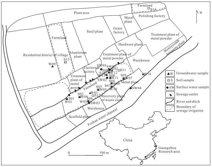
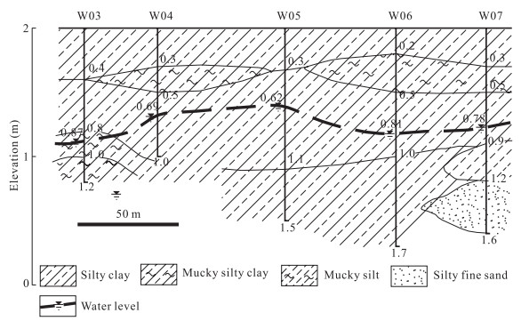
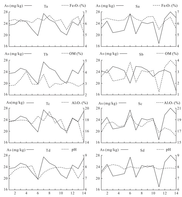
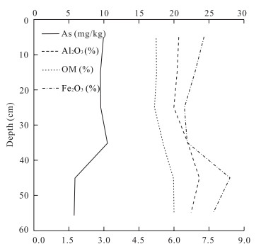
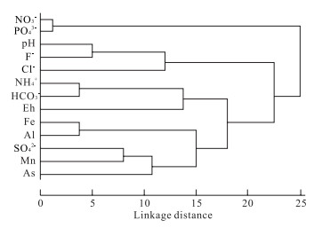
The aim of the present work is to investigate the distribution of arsenic (As) in sewage irrigation area, to deduce the migration and transformation mechanism of As in soil and groundwater, and to infer the source of As in soil and groundwater. This study is carried out in a sewage irrigation area of the Pearl River Delta, China. Surface water samples, soil samples, and groundwater samples from sewage irrigation area were analyzed for As and other elements. As contents in water samples were analyzed by hydride generation-atomic fluorescence spectroscopy, and As fractionation in soil samples was extracted using a seven-step sequential extraction method according to a seven fraction scheme: water soluble, ion exchangeable, bound to carbonate, weakly bound to organic matter, associated with oxides of iron (Fe) and manganese (Mn), strongly bound to organic matter, and the residual fraction. Waste water has content of As up to 16.8 μg/L in the study area. Soil has enriched As due to the irrigation of soil with waste water, and the total content of As in soil is about 0.7 times higher than the background value. Sequential extraction method reveals that the mean content of residual fraction in soil is more than 70%, releasable fraction (weakly organic fraction, Fe-Mn oxide fraction, and carbonate fraction) is about 20%-30%, whereas strongly organic and mobile fractions (water soluble and ion exchangeable) are within 0.2%. In the soil profile, the contents of water soluble, ion exchangeable, and carbonate fraction decrease with the depth, whereas the contents of other fractions are irregular with the depth. Using correlation analysis, it is concluded that water soluble fraction is easy to change into ion exchangeable and carbonate fraction, ion exchangeable fraction is easy to change into carbonate and Fe-Mn oxide fraction, and carbonate fraction is easy to change into weakly organic and Fe-Mn oxide fraction in the soil of study area. Organic matter and (hydr)oxides of Fe and aluminium (Al) in soil play an important role in controlling the distribution and mobility of As in soil. As concentrations in groundwater range from 2.8 to 21.0 μg/L, and it is inferred that As from waste water and the release of high As sediment (soil and aquifer medium) are the main sources for high As groundwater in study area. Using cluster analysis, it is concluded that reducing groundwater with slightly alkaline is beneficial to enrichment of As in groundwater, and hydroxides of Fe, Mn, and Al also play a key role for the enrichment of As in groundwater of the study area.
Comparison between Empirical Estimation by JRC-JCS Model and Direct Shear Test for Joint Shear Strength
Shigui Du, Yunjin Hu, Xiaofei Hu, Xiao Guo
2011, 22(3): 411-420. doi: 10.1007/s12583-011-0193-6
Abstract:
In order to study the reliability of the empirical estimation of joint shear strength by the JRC (joint roughness coefficient)-JCS (joint compressive strength) model, natural rock joints of different lithologic characteristics and different sizes were selected as samples, and their shear strengths under dry and saturated conditions were measured by direct shear test and compared to those estimated by the JRC-JCS model. Comparison results show that for natural rock joints with joint surfaces closely matched, the average relative error of joint shear strength between empirical estimation and direct shear test is 9.9%; the reliability of the empirical estimation of joint shear strength by the JRC-JCS model is good under both dry and saturated conditions if the JRC is determined accounting for directional statistical measurements, scale effect and surface smoothing during shearing. However, for natural rock joints with joint surfaces mismatched, the average relative error of joint shear strength between empirical estimation and direct shear test is 39.9%; the reliability of empirical estimation of joint shear strength by the JRC-JCS model is questionable under both dry and saturated conditions.