Advanced Search

Indexed by SCI、CA、РЖ、PA、CSA、ZR、etc .

2015 Vol. 26, No. 5

Display Method:
CONTENTS
2015, 26(5)
Abstract:
 
Zircon record of ocean-continent subduction transition process of dulan UHPM Belt, North Qaidam
Jianzhou Yang, Xiaochi Liu, Yuanbao Wu, Yanling Sun
2015, 26(5): 617-625. doi: 10.1007/s12583-015-0585-0
Abstract:
The North Qaidam UHPM (ultra-high pressure metamorphism) belt is a typical continental subduction-collision belt containing continental crust deep subduction metamorphic products and oceanic crust relics, And it is an ideal region to study the ocean-continent transition and exhumation mechanism of oceanic UHP rocks during continental deep subduction process. In this paper, we report integrated in situ U-Pb, Lu-Hf and O isotope analyses of zircons from a serpentinized harzburgite as well as U-Pb dating for zircons from a kyanite eclogite from the North Qaidam Dulan UHPM terrane, and use these data to discuss the ocean-continent transition and exhumation mechanisms of oceanic UHP rocks during continental deep subduction. The serpentinized harzburgite was dated at 448±9 Ma, consistent with 455±5 Ma age for the kyanite eclogite within analytical errors. Zircons from the serpentinized harzburgite have uniform 176Hf/177Hf values ranging from 0.282 842 to 0.282 883 and εHf(t) values from 11.6 to 13.3. Zircon δ18O values of the serpentinized harzburgite vary from 4.47‰ to 5.29‰, slightly lower than the value of 5.3‰±0.6‰ for the normal mantle zircon. These Hf-O isotopic features indicate that the protolith of the serpentinized harzburgite was derived from depleted-mantle source, and might have experienced high-temperature rock-water interaction. Therefore, the serpentinized harzburgite was possibly located in the lower part of an oceanic section. The serpentinized harzburgite and kyanite eclogite were both formed due to the subduction of oceanic crust. The UHP metamorphism occurred successively from the oceanic crust to continental crust rocks of the North Qaidam UHP terrane. Low-density serpentinized peridotite and continental rocks possibly have negative buoyancy and play a key effect on preservation and exhumation of high-density oceanic eclogite.
Geochemistry of enclaves and host granitoids from the kashan granitoid complex, central iran: Implications for enclave generation by interaction of cogenetic magmas
Maryam Honarmand, Nematollah Rashidnejad Omran, Franz Neubauer, Ghasem Nabatian, Mohammad Hashem Emami, Albrecht von Quadt, Yunpeng Dong, Manfred Bernroider
2015, 26(5): 626-647. doi: 10.1007/s12583-015-0584-1
Abstract:
The major and trace elements and Sr-Nd-Pb isotopes of Miocene host granitoid rocks and their mafic microgranular enclaves (MMEs) were studied to understand the petrogenesis of MMEs in the Kashan complex, which is part of the Urumieh-Dokhtar magmatic belt (Iran). The host rocks consist of quartz-diorite and tonalite associated with a dioritic intrusion. The enclaves show microgranular texture and the same mineralogy as their respective host with plagioclase, quartz and biotite. MMEs have a diorite to quartz-diorite composition and show geochemical characteristics mostly between their granitoid host and the diorite intrusion. Chondrite-normalized REE patterns of all samples are moderately fractionated [(La/Yb)N=2.1 to 12.9]. The MMEs display in part small negative Eu anomalies (Eu/Eu*=0.54 to 0.99), with enrichment of LILE and depletion of HFSE. The enclaves show emplacement depth of ~4 to 6 km which is comparable with the host rocks. Moreover, the Hornblende-plagioclase equilibrium temprature of MMEs yields average temperatures of 795℃ which is slightly higher than the host ones. Identical mineral compositions and Nd-Sr-Pb isotopic features of MME-host granitoid pairs indicate interactions and parallel evolution of MME and enclosing granitoid in the Kashan plutons. Additionally, the geochemical and isotopic investigations of host and dioritic intrusions suggest a common source for their genesis. A thermal anomaly induced by underplated basic magma into a hot crust would have caused partial melting in the lower crust to generate Kashan granitoid rocks.
An object-oriented diagnostic model for the quantification of porewater geochemistry in marine sediments
Hong Ye, Tao Yang, Guorong Zhu, Shaoyong Jiang
2015, 26(5): 648-660. doi: 10.1007/s12583-015-0586-z
Abstract:
The reaction-transport model is widely used to identify and quantify dissolved chemical species in sediment porewaters. In this paper, a modularized code framework of diagenetic model was proposed as a diagnostic tool to fit the porewater profiles in marine sediments. Based on the conservation principle of the finite volume method, we combined the discretized diagenetic equations with various geochemical reactions, including but not limited to methanogenesis, sulfate reduction, etc.. The code was organized in object-oriented FORTRAN and verified with literature parameters, which proved its robustness and effectiveness. Finally, three different sites (IODP Expedition 311 Site U1327, UBGH2-1_1, ODP Leg204 Site 1245) are exemplified as case studies.
Subterranean origin of accreted lapilli in cone-sheets of the houshihushan sub-volcanic ring complex, Shanhaiguan, China
Xia Wen, Changqian Ma, Roger Mason, Longkang Sang, Junming Zhao
2015, 26(5): 661-668. doi: 10.1007/s12583-015-0581-4
Abstract:
In addition to syenite ring dykes and multiple alkaline granite stocks, the sub-volcanic Houshihushan alkaline ring complex near Shanhaiguan, Qinhuangdao City, contains cone-sheets of two types: a majority filled with granite porphyry and a minority filled with quartz syenite porphyry. Many cone sheets show evidence of multiple magma intrusion events. Some granite porphyry sheets' multiple chilled margins display magmatic roll structures indicating that turbulent magma flowed up the fractures. In one upward-closing cone-sheet K-feldspar phenocrysts floated up through fluid granite porphyry magma and became concentrated at the top providing direct evidence of shallow-level crystal fractionation, confirmed by published rock analyses. Accreted lapilli with K-feldspar crystal cores occur only in the inner parts of a minority of cone-sheets and field relationships indicate that they must have formed beneath the ground surface. Similar lapilli occur in erupted ignimbrites preserved in the collapsed caldera. Voids between lapilli in cone-sheets indicate the presence of volumes of gas below the surface that could have flowed upwards as fast-moving hot gas streams. We propose a mechanism of formation that began with subterranean magmatic rolls with K-feldspar crystal cores that formed on dyke walls, and became detached. Then they were caught up in rising gas streams and erupted at the surface. Thus accreted lapilli formed underground, were erupted along with blobs of fluid glass in escaping gases, and transported over the surface in nuées ardentes, to settle and cool as ignimbrite flows.
Sr-Nd-Pb Isotopic compositions of the Neogene Eolian Deposits in the Xining Basin and Implications for Their Dust Sources
Fangming Zeng, Meiyan Liang, Shuzhen Peng, Dongmei Yu, Shuyuan Xiang
2015, 26(5): 669-676. doi: 10.1007/s12583-015-0575-2
Abstract:
The Neogene eolian deposits in the Xining Basin are valuable archive for studying the evolution of the Asian monsoon system and geomorphic processes of Northwest China. The Neogene eolian deposits that paleomagnetically dated at about 14 Ma probably were sourced from the middle and west Qinghai-Tibetan Plateau (QTP) as indicated by elemental compositions and magnetic properties. This study provides the Sr-Nd-Pb isotopic ratios of different sediments (gravels from the river terraces, Neogene eolian deposits and Quaternary loess) in the Xining Basin. The results show that: (1) Sr-Nd isotopic compositions of terrace gravels are different from those of the Neogene and Quaternary eolian deposits, although the Nd isotope ratios of gravel on the 10th terrace (T10) and eolian deposits are similar. (2) Pb isotopic compositions of river gravels are obviously different from the eolian deposits in the Xining Basin. However, Pb isotopic compositions of eolian deposits in the basin are similar to those of eolian deposits in the central Chinese Loess Plateau. (3) Sr-Nd-Pb isotope results indicate that the Neogene eolian deposits in the Xining Basin were probably sourced from remote areas outside of the basin by long-distance transportation. The Qaidam Basin is probably an important source area for the eolian deposits in the Xining Basin.
Characteristics, Genesis, and Sedimentary Environment of Duplex-Like Structures in the Jurassic Sediments of Western Qaidam Basin, China
Liangtian Ni, Jianhua Zhong, Zhufu Shao, Yong Li, Cui Mao, Shengxin Liu
2015, 26(5): 677-689. doi: 10.1007/s12583-015-0578-2
Abstract:
A particular type of soft-sediment deformation structure, similar to imbricate structure, is developed in the Jurassic strata at Honggouzi, western Qaidam Basin, China. We refer to this structure as a duplex-like deformation structure, because it is inferred to have been formed by the action of fast-moving, submarine gravity current sediments gliding across a pre-existing semiconsolidated sedimentary layer. The layers of duplex-like structure crop out in the southeastern limb of the core of a medium-sized anticline. The average dip direction of the duplex-like structure is 301.2° and the average dip angle is 54.7°. Duplex-like deformed laminations are composed mainly of weakly metamorphosed, extremely poorly sorted, feldspathic lithic graywacke. Sericite can be observed along bedding planes. The duplex-like structure occurs within a sequence of river-channel fine conglomerate, interchannel carbonaceous mudstone (shale), shallow-water delta sand-shale, shallow-lake calcareous mudstone, olistostromes, and a turbidite. At the bottom of the sequence, we found brownish-red shallow-lake calcareous mudstone and carbonaceous mudstone and at the top olistostromes whose genesis is related to the slip and drag of a slumped body of submarine sediment. In combination with other symbiotic and associated structures, it is considered that the duplex-like structure was formed by the slumping and subsequent movement and traction of delta-front semiconsolidated sediments over the bottom sediments of a shore or shallow-lake sedimentary environment, probably triggered by an earthquake. The attitude of the duplex-like structure indicates that the direction of gliding was from NW301.2° toward SE121°, which is consistent with the current location of the Altun Mountains, indicating that the Altun Mountains existed in the Jurassic. The orogenesis of these mountains likely involved seismic activity, and an earthquake was the triggering factor in the formation of the duplex-like structure by causing the slumping/gliding of the olistostrome sediments.
En Echelon Faults and Basin Structure in Huizhou Sag, South China Sea: Implications for the Tectonics of the SE Asia
Boubacar Hamidou Leyla, Jianye Ren, Jing Zhang, Chao Lei
2015, 26(5): 690-699. doi: 10.1007/s12583-015-0588-x
Abstract:
The Huizhou sag is situated on the continental shelf of the northern continental margin of the South China Sea. In this paper we present a grid of reflection seismic and well data to characterize the basin structure and prominent unconformities. We employ EBM and 2DMOVE softwares to explore the subsidence history and stratigraphic development history of the basin. We found a rapid subsidence period since 15.5 Ma. Moreover, we calculated the stretching factors of the upper crust and the whole crust in the Huizhou sag. The results show the values are 1.10–1.13 and 1.08–1.31, respectively, indicating faulting in Huizhou sag is relatively small. It is noteworthy that the faults map reveals en echelon distribution at the north and south margins of the basin. We suggest en echelon faults here are caused by the subduction of Proto-South China Sea toward NW Borneo block and cease of the South China Sea. Considering the pronounced unconformities, subsidence rates, fault activities and sediment thickness, the Cenozoic tectonic evolution of the basin can be divided into rifting (49–32 Ma), post-rifted (32–15.5 Ma) and rapid subsidence (15.5–0 Ma) stages. Our study will shed new light on the tectonics of SE Asia and petroleum exploration in the South China Sea.
Lacustrine Shale Deposition and Variable Tectonic Accommodation in the Rift Basins of the Bohai Bay Basin in Eastern China
Chuanyan Huang, Jinchuan Zhang, Hua Wang, Shu Jiang
2015, 26(5): 700-711. doi: 10.1007/s12583-015-0602-3
Abstract:
Organic-rich lacustrine shales are widely distributed in China and have significant potential for unconventional shale gas and oil production although the primary factors controlling the deposition of lacustrine shale are disputed. This work clarifies the different characteristics of tectonic evolution and shale among sub-basins in the Bohai Bay Basin in eastern China as a case study by studying basal subsidence, tectonic subsidence rate, basin extensional proportions and shale chemical characteristics. The paper summarizes the correlation between structure and shale deposition, and concludes that tectonic activity is the primary controlling factor for shale development. Episodic tectonic activity controls not only the timing of shale deposition (with the greatest shale deposition occurring primarily during the peak period of basin tectonic activity) but also the spatial distribution of shale (located mainly in areas of maximum subsidence), the migration pattern of shale (conforming to that of the basin subsidence center), and shale strata thickness. Tectonic activity also affects the total organic carbon content and organic matter type in shale. When the tectonic activity was the most active and basal subsidence was the maximum, the total organic carbon content of the shale reached its highest value with organic matter type mainly Type Ⅰ. As tectonic activity weakened, the total organic carbon content decreased, and the organic matter type changed from Type Ⅰ to Type Ⅰ-Ⅲ.
GIS-Based analysis of relative tectonic activity along the kazerun fault zone, zagros mountains, iran: insights from data mining of Geomorphic Data
Ali Faghih, Ahmad Nourbakhsh, Timothy M. Kusky
2015, 26(5): 712-723. doi: 10.1007/s12583-015-0583-2
Abstract:
This paper tests a data mining method for evaluation of the "IRTA" (Index of Relative Tectonic Activity) to investigate the impact of active tectonics on geomorphic processes and landscape development. Based upon K-means clustering of six basin-related geomorphic indices (the hypsometric integral, basin asymmetric factor, drainage density, basin shape ratio, mean axial slope of the channel and topographic roughness) that represent the relative strength of active tectonic deformation on topography and morphology, the relative tectonic activity along the Kazerun Fault Zone in the Zagros Mountains of Iran may be classified into low, moderate and high relative tectonic activity zones. The results allow the identification of the clusters of similarly deformed areas related to relative tectonic activity. The utilization of geomorphic parameters as well as IRTA with comparison to the field observations exhibit change in relative tectonic activities mostly corresponding to the change in mechanism of the prominent fault zones in the study area.
An Adaptive 2D Planar Projection and Its Application in Geoscience Studies
Yong Zheng, Bikai Jin, Xiong Xiong, Sidao Ni
2015, 26(5): 724-728. doi: 10.1007/s12583-015-0591-2
Abstract:
A linear projection approach is developed to present geoscience research result in planar coordinate system projected from spherical coordinate system. Here, the sphere is intersected by a plane and its surface is projected onto the plane. In order to keep the projected coordinate system orthogonal, and minimize the distortion, one axis of the planar coordinate system is chosen in our projection based on the shape of the region to be projected, and the other axes can be chosen arbitrarily or based on the constraint of the orthogonality. In the new method the projection is self-contained. The forward projection can be fully projected backward without loss of precision. The central area of the sphere will be projected to the planar system without distortion, and the latitudinal length in the rotated spherical system keeps constant during the projecting process. Only the longitudinal length in the rotated spherical system changes with the rotated latitude. The distortion of the projection therefore, overall, is small and suitable for geoscience studies.
Stratigraphical Study of the Taft Formation in the Bohruk Area from Yazd Block, Central Iran
Seyed Ahmad Babazadeh, Taiebeh Esmaeili Dehej
2015, 26(5): 729-739. doi: 10.1007/s12583-015-0580-5
Abstract:
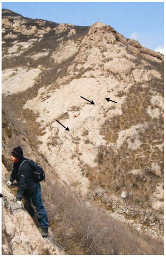
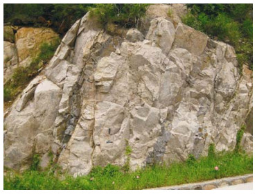
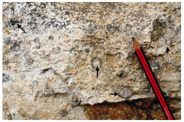
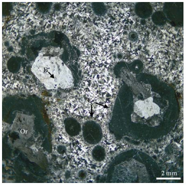
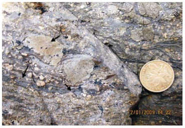
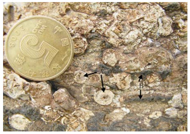
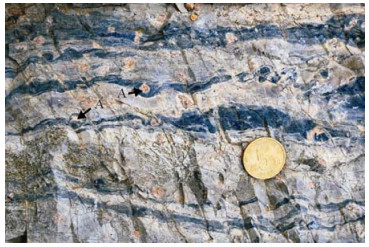
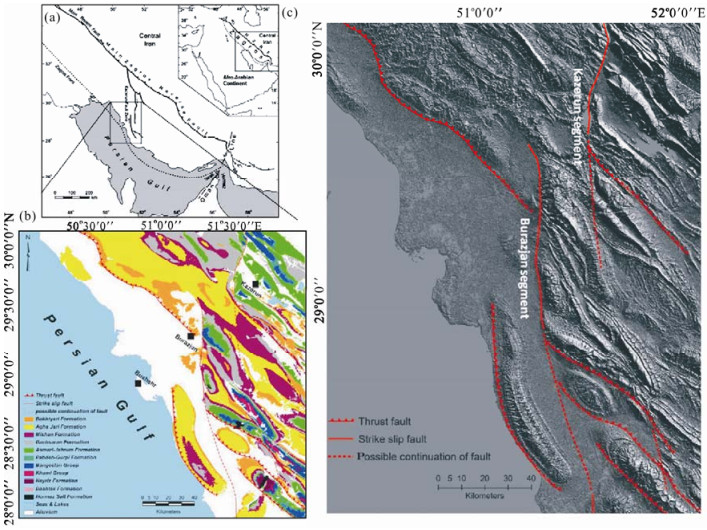
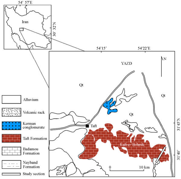
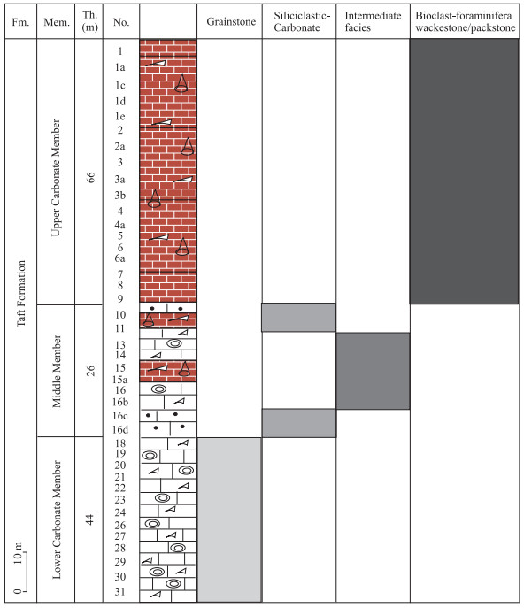
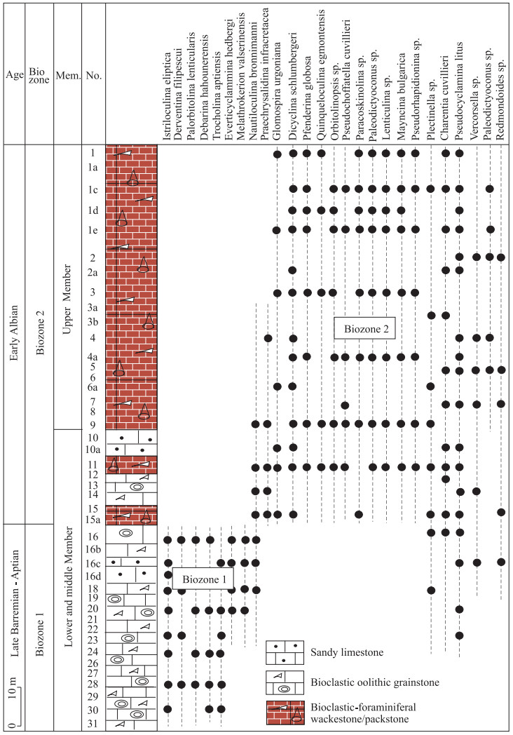
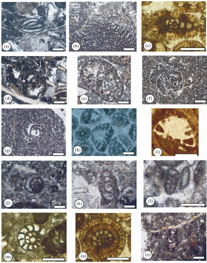
The Taft Formation is exposed at the Bohruk area from Yazd Block in central Iran with 136 m thickness comprising three informal members which are named, in ascending stratigraphical order named Lower, Middle and Upper members. The Lower and Upper members consist of bioclastic carbonate rocks, whereas the Middle Member contains two sub-members: carbonate and siliciclastic carbonate rocks. Four patterns of facies are recognized on the basis of field observation and microscopic study. They are grainstone facies, siliciclastic-carbonate facies, intermediate facies (grainstone-wackestone/packstone facies) and foraminiferal-clastic wackestone/packstone facies. Based on the facies associations, three facies belts are presented for the first time. Therefore, this formation was deposited on a shallow carbonate platform from the inner platform to rimmed platform. The main fauna of the Taft Formation includeIstriloculina eliptica (Iovcheva), Palorbitolina lenticularis (Blumenbach), Charentia cuvillieri Neumann, Everticyclammina hedbergi (Maync), Pseudocyclammina litus (Yokoyama), Melathrokerion valserinensis Bronnimann & Conrad, Nautiloculina oolithica Mohler, Glomospira urgoniana Arnaud Vanneau, Dicyclina schlumbergeri Munier-Chalmas, Derventina filipescui Neagu, Praechrysalidina infracretacea Luperto-Sinni, Pseudochoffatella cuvillieri Deloffre, Paracoskinolina sp., Textularia sp., and Lenticulina sp. Based on the foraminiferal distribution throughout the Taft Formation, two biozones like Istriloculina elliptica-Palorbitolina lenticularis zone and Glomospira urgoniana-Dicyclina schlumbergeri zone are recognized they and range from the Late Barremian to Early Albian in age.
Impact Craters with Circular and Isolated Secondary Craters on the Continuous Secondaries Facies on the Moon
Shangzhe Zhou, Zhiyong Xiao, Zuoxun Zeng
2015, 26(5): 740-745. doi: 10.1007/s12583-015-0579-y
Abstract:
On airless bodies such as the Moon and Mercury, secondary craters on the continuous secondaries facies of fresh craters mostly occur in chains and clusters. They have very irregular shapes. Secondaries on the continuous secondaries facies of some Martian and Mercurian craters are more isolated from each other in distribution and are more circular in shape, probably due to the effect of target properties on the impact excavation process. This paper studies secondaries on the continuous secondaries facies of all fresh lunar complex craters using recently-obtained high resolution images. After a global search, we find that 3 impact craters and basins on the Moon have circular and isolated secondaries on the continuous secondaries facies similar to those on Mercury: the Orientale basin, the Antoniadi crater, and the Compton crater. The morphological differences between such special secondaries and typical lunar secondaries are quantitatively compared and analyzed. Our preliminary analyses suggest that the special secondaries were probably caused by high temperature gradients within the local targets when these craters and basins formed. The high-temperature of the targets could have affected the impact excavation process by causing higher ejection angles, giving rise to more scattered circular secondaries.
Seismicity and Seismotectonics of Jeddah-Makkah Region, West-Central Saudi Arabia
Mohammed Fnais, Abdullah Al-Amri, Kamal Abdelrahman, Enayat Abdelmonem, Sherif El-Hady
2015, 26(5): 746-754. doi: 10.1007/s12583-015-0587-y
Abstract:
Jeddah-Makkah regionis have been suffering from earthquake crisis where some moderate to destructive earthquakes have been recorded. These earthquake activities are oriented along major faults or clustered in certain spots. Moreover, these earthquake events have annual recurrence periods, so the identification of these seismogenic source zones is of utmost importance for mapping the most hazardous localities which should be avoided in the future urban planning. Historical and instrumental earthquakes have been collected from national and international data centers and unified in catalogue. The existence of microearthquakes inland suggests that there is a significant level of tectonic activity at away from the axial trough of the Red Sea. Then, seismogenic source zones have been defined depending on the major tectonic trends; distribution of earthquake epicenters, seismicity rate (a & b-values) and fault plane solution of major earthquakes. It is concluded that Jeddah-Makkah region is affected by the outlined five seismogenic source zones; three of these zones aligned of the main Red Sea axial trough (southwestern Jeddah, western Jeddah, and northwestern Jeddah zones), while the other two zones are located in the land area of the region (Thewal-Rabegh and Jeddah-Makkah zones). These inland zones correlated well with the main trends of major tectonics which refleet the reactivation of tectonic movements along these fault trends. The Red Sea zones are in agreement with the main path of the axial trough. The range of b-value in these identified zones is 0.65 to 1.03 through these identified zones. The area characterized by higher b-values could be indicative of a relative low stress regime which was a result of resulting from the stress release by the earthquakes. Whereas, the areas of lower b-values can be considered as an evidence of a relatively higher stress regime associated with a dominantly extensional stresses. Based on aforementioned, the region is suffering from different stress level accumulations which, in turn, cause earthquakes with different magnitudes. Accordingly, deployment of local seismograph network through Jeddah-Makkah region is highly recommended. These results will support, to a great extent, seismic hazard assessment and risk mitigation of the region.
Determination of Carbonate Minerals Responsible for Alkaline Mine Drainage at Xikuangshan Antimony Mine, China: Using Thermodynamic Chemical Equilibrium Model
Tananga Mathews Nyirenda, Jianwei Zhou, Lina Xie, Xizhe Pan, Yi Li
2015, 26(5): 755-762. doi: 10.1007/s12583-015-0590-3
Abstract:
Minerals responsible for mine water quality at the Xikuangshan antimony mine were identified and characterized by a computer-assisted thermodynamic chemical equilibrium model. A total of 30 samples were collected and analyzed for major cations and anions. The Eh-pH diagrams identified Fe2O3 as the dominant iron species, while SO42- was the dominant sulfide species, which indicates acid production. The major acid producing minerals undergoing oxidation were identified to be pyrite, pyrrhotite, arsenopyrite and siderite. Other secondary sulfide minerals that contributed to SO42- concentration in the groundwater were gypsum and epsomite. Calcite and dolomite were the main buffering carbonate minerals. Identification of the specific acid producing and consuming minerals occurred in the mine area is critical to determine an effective water management plan.
Review of High-Precision Sr Isotope Analyses of Low-Sr Geological Samples
Jie Lin, Yongsheng Liu, Haihong Chen, Lian Zhou, Zhaochu Hu, Shan Gao
2015, 26(5): 763-774. doi: 10.1007/s12583-015-0593-0
Abstract:
Isotope plays an important role in both tracing and dating in earth science, especially 87Rb-86Sr system. With the development of earth science, whole-rock analysis can't sufficiently meet the requirements for scientific research and the micro-analysis becomes more and more significant. Laser ablation multi-collector inductively-coupled plasma mass-spectrometry (LA-MC-ICP-MS) has been extensively applied in micro-zone analysis due to its low sample-consumption, high accuracy, in situ and low requirements on matrix, but it is still difficult to accurately measure Sr isotope compositions especially for the samples with high Rb/Sr ratios and low Sr contents as it is restricted by severe quality discrimination and various types of mass spectrum interferences. Consequently, thermal ionization mass-spectrometry (TIMS), as the most accurate and precise method to analyze isotopic ratios, is still the most popular method of analyzing Sr ratios, especially for the samples with low Sr contents. This paper makes a systematic review on the high-precision Sr isotope analyses of low-Sr geological samples, including the micro-sampling technique, ultra-low procedural blank chemical method and TIMS measurement technique. The combination of ultra-low procedural blank and TIMS can be used to perform high-precision micro-analysis of the samples with ng magnitude, which will be undoubtedly an important direction for Rb-Sr geochronology, geochemistry and environmental studies.