Advanced Search

Indexed by SCI、CA、РЖ、PA、CSA、ZR、etc .

2001 Vol. 12, No. 3

Display Method:
 
Rheological Strength of UHP Eclogite from Dabieshan: Evidences from High p-T Experiments
Junfeng Zhang, Zhenmin Jin, H W Green, Shuyan Jin
2001, 12(3): 189-194.
Abstract:

We present here experimental study of the rheological properties of UHP eclogite from Dabie at a pressure of 3 GPa by utilizing the 5 GPa Griggs type piston cylinder apparatus. The rheological constitutive equation of eclogite is determined with a stress exponent of 3.4, an activation energy of 480 kJ/mol and a preexponential factor of 103.3. Our study shows that: (1)As a typical two-phase rock, the flow strength of eclogite depends on the proportions of the strong phase(garnet)and the weak phase(omphacite); (2)The plastic deformation of eclogite is dominated by dislocation creep; (3)Based on that eclogite has the same strength as the upper mantle harzburgite, our study suggests that the delamination of the subducting crust component from the underlying upper mantle is unlikely. Therefore, the stretching after the collision orogeny coupled with the upwelling of the upper mantle may play a more important role in the exhumation of UHP rocks.

On Geodynamic Evolution of Simao Region (Southwestern Yunnan, China) during Late Paleozoic and Triassic
D Helmcke, R Ingavat-Helmcke, Qinglai Feng, B Wagner, K Heppe
2001, 12(3): 195-200.
Abstract:

Over the last years, the Simao region, southwestern Yunnan, China, turned out to be a very promising target to elucidate plate tectonic processes around the Permian Triassic boundary within the Tethyan domain of Asia. New data from this area reveal that Upper Paleozoic compressional deformations occurred along the Lancangjiang and in areas to the east. Along Lancangjiang, an angular unconformity is exposed, which separates quartz phyllites—formed during a Carboniferous tectono metamorphic event—from Triassic red beds to roofing rhyolites. The acidic volcanics were often said to be remnants of a volcanic arc that was active during the Triassic subduction and closure of an oceanic realm along the Lancangjiang zone. According to our new data, however, these volcanics indicate most probably an Upper Triassic stage of rifting. In the Yunxian anticline (NW of Simao), an angular unconformity of intra Permian age is exposed where Carboniferous to lower Middle Permian strata, which were deposited in a rather deep basin, are unconformably overlain by a shallow marine sequence of upper Middle to Upper Permian sediments. The angular unconformity is of the same age as the syn orogenous sediments first described and dated from the Phetchabun region in Thailand and hence a convincing argument for a Late Variscan orogeny forming an extensive zone of mountain building that can be traced through the central parts of mainland Southeast Asia.

Tracing Disrupted Outer Margin of Paleoeurasian Continent through Union of Myanmar
Min Myo, Khinlin Khin, Qinglai Feng, Chonglakmani Chongpan, Meischner Dieter, Rucha Ingavat-Helmcke, Dietrich Helmcke
2001, 12(3): 201-206, 271.
Abstract:

Based on stratigraphy?facies distribution and paleontology of upper Paleozoic and Triassic strata in Malaysia, Thailand, Myanmar and Yunnan (China), the location of the division between the outer margin of the disrupted Paleoeurasian continent and possible Gondwana-derived terranes is discussed.It is proposed that this division is located much further to the west than that has usually been maintained.

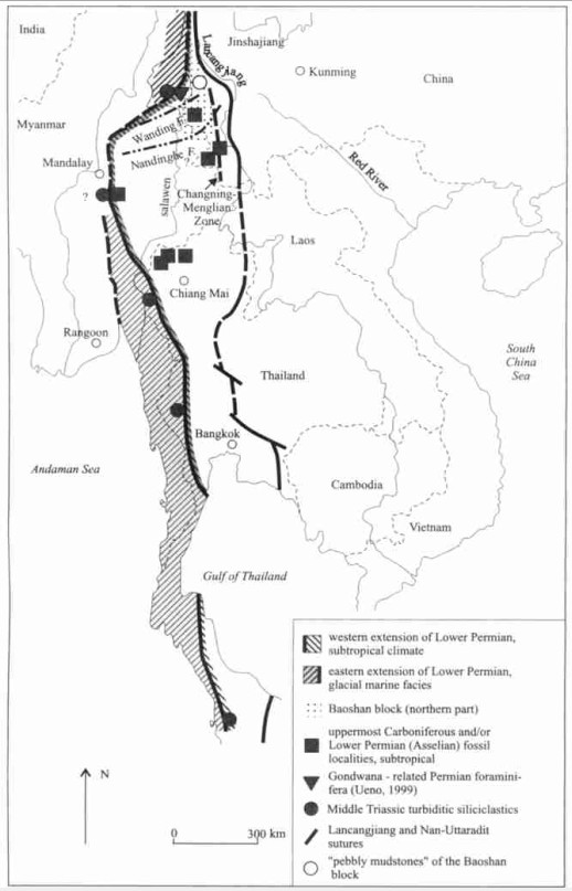
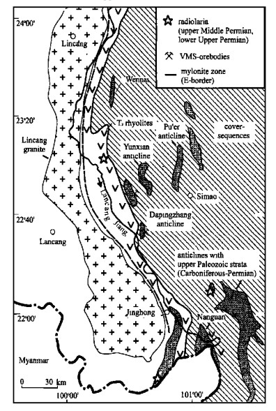
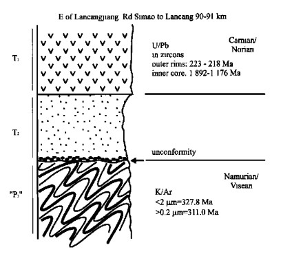
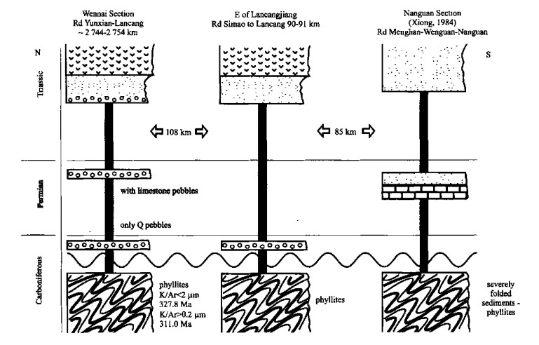
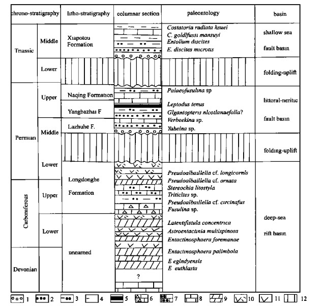
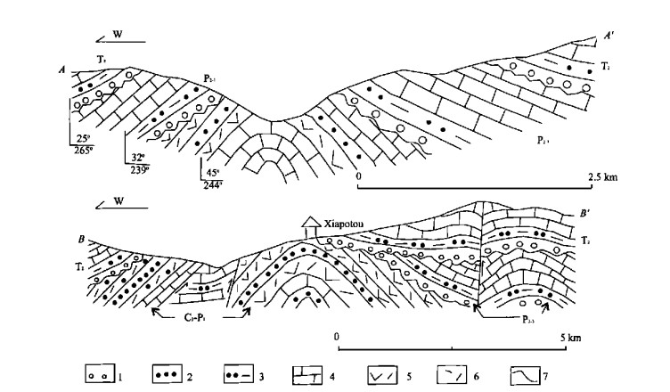
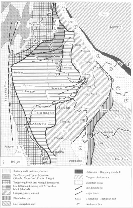
Correlation of Tectono-Stratigraphic Units in Northern Thailand with Those of Western Yunnan (China)
Chonglakmani Chongpan, Qinglai Feng, Meischner Dieter, Rucha Ingavat-Helmcke, Dietrich Helmcke
2001, 12(3): 207-213.
Abstract:

A tentative correlation scheme for the tectono-stratigraphic units of Northern Thailand and those of Western Yunnan (China) is proposed.We point out that a correlation between the ChangningMeng-lian belt in Western Yunnan and the Nan-Uttaradit zone in Northern Thailand (or and a "cryptic suture" in the Chiang Ra-i Chiang Mai region) is unlikely?for it would demand a "suture" which cuts across a zone with high-grade metamorphics and granite intrusions (Doi Inthanon-Lincang unit).Therefore, the northern continuation of the Lampang region is situated in the Simao region of Yunnan, as indicated by a very similar development during Permian and Triassic (Lampang-Yunxian unit).The Nan-Uttaradit zone is considered to be the easternmost part of this unit, and its northern continuation should be traceable via Luang Prabang in Laos into the southeastern parts of the Simao basin.Here, however, outcrops of this unit have not yet been found.The same is the case with the Phetchabun unit which follows to the east.Both units are probably hidden under a thick cover of Mesozoic red beds.The whole region was characterized by a highly mobile tectonic development with alternating phases of compressional and extensional deformation.

Aragonite from Mulanshan Glaucophane Schist: Implications for Regional Evolution of Southwestern Dabie Mountains, Central China
Rong Liu, Qinyan Wang, Wenyu Zhao, Changqi Peng, Qingjie Zhang
2001, 12(3): 214-220.
Abstract:

The aragonite, an index mineral of glaucophane schist facies, has not been confirmed in the Dabie Mountains high pressure and ultrahigh pressure metamorphic belts. The Mulanshan glaucophane schist in Huangpi County, Hubei Province is located in the southwestern Dabie Mountains, Central China. The micron sized intergranular aragonite is confirmed with optical microscope (OM) and electron probe microanalysis (EPMA) in the glaucophane schist. The submicrometer sized ellipse aragonite inclusion is observed by using bright field image (BFI), X ray energy damage spectrograph (EDS) and selected area electron diffraction (SAED) with transmission electron microscope in the quartz lens of glaucophane albite epidote chlorite schist from Mulanshan. The presence of aragonite indicates not only the average geothermal gradient of the Mulanshan glaucophane schist less than 10 ℃/km, which is very close to that of eclogite in the Dabie Mountains metamorphic belts, but also the relatively higher concentration of CO2 during the metamorphic process. In addition, the glaucophane schist free of such index minerals as lawsonite, prehnite and pumpellyite, has been attributed to the effect of CO2 on the stability of calcium aluminum silicate minerals during the low grade metamorphism. EDS and SAED analysis results show that the host of aragonite inclusion is amorphous SiO2. The occurrence of amorphous SiO2 indicates a quick cooling process during the exhumation of the Mulanshan glaucophane schist. These results suggest that the rapid exhumation mechanism of the glaucophane schist, the same as that of eclogite in the Dabie Mountains metamorphic belts, occurred in the geodynamic context of subduction obduction.

Electrical Calibration for Calvet Type Microcalorimetry
Jiawei Chen, Zhengyu Bao, Yuping Mei
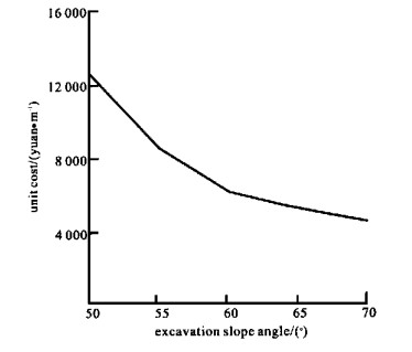
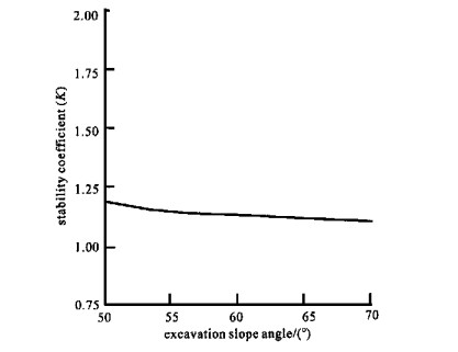
2001, 12(3): 232-235.
Abstract:

The device construction and working principle of Calvet type heat conductive microcalorimetry are generally introduced in this paper. Based on previous work, we design a reactor vessel and its electrical calibration equipment according to our special study systems. The heat constant of our improved microalorimetry is gotten by means of electrical calibration on the basis of Tian's equation. The results gotten by integration method are identical with ones gotten by peak method. It shows that our improved device works well enough to develop further studies.

Trace Elements Analysis of Geological Samples by Laser Ablation Inductively Coupled Plasma Mass Spectrometry
Yan Luo, Yongsheng Liu, Shenghong Hu, Shan Gao, Shoulin Lin
2001, 12(3): 236-239.
Abstract:

This paper describes recent work applying a laser ablation system (LSX-200) hyphenated with POEMS Ⅲ inductively coupled plasma mass spectrometry (LA-ICP-MS) for the in situ analysis of22 trace elements of solid geological materials.It demonstrates the potential of LA-ICP-MS for the determination of geochemically important trace and ultra-trace elements following XRF routine sample preparation.Signal drift, difference in transport efficiency and sampling yield are well corrected with NISTSRM612as external calibration standard and Ca as internal standard.The obtained results agree to the recommended values with relative error better than15% and RSD less than15% for most determined trace elements.LOD ranges from 0.021×10⁻⁶to 0.23×10⁻⁶and less than 0.10×10⁻⁶ for majority trace elements determined.In addition, home-made macro functions including filter and calculator compiled by VBA language under Excel software greatly enhanced off-line data reduction efficiency.

Application of Stochastic Fracture Network with Numerical Fluid Flow Simulations to Groundwater Flow Modeling in Fractured Rocks
Mingyu Wang, Jinsong Chen, Li Wan
2001, 12(3): 240-248.
Abstract:

The continuum approach in fluid flow modeling is generally applied to porous geological media, but has limited applicability to fractured rocks. With the presence of a discrete fracture network relatively sparsely distributed in the matrix, it may be difficult or erroneous to use a porous medium fluid flow model with continuum assumptions to describe the fluid flow in fractured rocks at small or even large field scales. A discrete fracture fluid flow approach incorporating a stochastic fracture network with numerical fluid flow simulations could have the capability of capturing fluid flow behaviors such as inhomogeneity and anisotropy while reflecting the changes of hydraulic features at different scales. Moreover, this approach can be implemented to estimate the size of the representative elementary volume (REV) in order to find out the scales at which a porous medium flow model could be applied, and then to determine the hydraulic conductivity tensor for fractured rocks. The following topics are focused on in this study: (a) conceptual discrete fracture fluid flow modeling incorporating a stochastic fracture network with numerical flow simulations; (b) estimation of REV and hydraulic conductivity tensor for fractured rocks utilizing a stochastic fracture network with numerical fluid flow simulations; (c) investigation of the effect of fracture orientation and density on the hydraulic conductivity and REV by implementing a stochastic fracture network with numerical fluid flow simulations, and (d) fluid flow conceptual models accounting for major and minor fractures in the 2 D or 3 D flow fields incorporating a stochastic fracture network with numerical fluid flow simulations.

Isotopic Stratification and Its Implications in Groundwater of Northern China
Zongyu Chen, Guanghui Zhang, Zhenlong Ni, Jixiang Qi, Yunju Nan
2001, 12(3): 249-257.
Abstract:

The contents of D, 8O, 3H and 14C, distinctive in shallow and deep Quaternary aquifers beneath northern China, reflect differences in average paleoclimatic conditions between the Holocene and the last glacial period in Pleistocene.Groundwater in deep confined aquifer was recharged during the last glacial period.The depletions of δ(D) and δ(18O) of this water, 4×10⁻³-16×10-3 and 1×10⁻³-2×10⁻³ when compared with the shallow water recharged in Holocene, suggest that the annual mean temperature was lower in the last glacial period than that in the Holocene.The continental gradient of D and 18O found in old groundwater is essentially similar to that in Holocene, suggesting that the atmospheric circulation did not undergo substantial changes over northern China for the past 30 000 years in spite of the changes in the temperature.Groundwater isotopic stratification indicates three different recharge mechanisms and the influence of modern hydrological circulation, which are very important for the understanding of the continental hydrological circulation and the sustainable development of groundwater resources.

Optimum Design of Highway Excavation Slope Angle: Evidence from Dawu Section of Jingzhu Highway
Xinli Hu, Huiming Tang
2001, 12(3): 258-260.
Abstract:

The optimum design of the highway excavation slope angle is one of the most important problems to the highway construction and to the slope improvement. The Dawu Section of Jingzhu (Beijing Zhuhai) Highway is taken as an example to illustrate the study method for excavation slope angle design. The analysis of the engineering condition from different angles with different factors shows that the stability of the slope is calculated by using residual pushing force and the Sarma method. Then the sensitive analysis of the slope stability is conducted by using residual pushing force method. Finally, the optimum angle of design is presented on the precondition of ensuring the whole stability of slope and the economic reasonability. The study results show that the most sensitive factors are the shear strength parameter and the seismic force, and that the optimum excavation slope angle is 60°.

Cause Analysis of Wuhan Tianheng Building Pile Accident
Zhongxian Zhang, Lin Xu, Jiaxiang Tang
2001, 12(3): 261-265.
Abstract:

The geological condition and the original structure feature and foundation design of Wuhan Tianheng building are described. The accident appearance of pile foundation in the construction execution of work is illustrated. The generating source of this pile foundation accident is analyzed in great details.

Identification and Correction for MT Static Shift Using TEM Inversion Technique
Changfu Yang, Changyou Lin
2001, 12(3): 266-271.
Abstract:

The inversion of TEM data, using the observed magnetic fields instead of that of apparent resistivities data in this paper, avoids the errors caused by the definition of the apparent resistivity. The inversed results by fitting the magnetic fields of the transmitter source's image with the observed magnetic fields are relatively less affected by the conductivity inhomogeneity. The MT apparent curve is calculated on the basis of the conductivity model constructed from the TEM inversion results. This curve is used as a reference curve for the correction of MT static shift, which makes the correction more reliable. Meanwhile, the domain transformation is also achieved from time to frequency between the two kinds of electromagnetic data. Therefore, the correction of the MT static shift is actualized using TEM inversion method. The corresponding application research shows that this method is very effective for the identification and correction of the MT static shift.

Fractal Correction of Well Logging Curves
Qingmou Li, Qiuming Cheng
2001, 12(3): 272-275.
Abstract:

It is always significant for assessing and evaluation of oil bearing layers, especially for well logging data processing and interpretation of non marine oil beds to get more accurate physical properties in thin and inter thin layers. This paper presents a definition of measures and the measure presents power law relation with the corresponded scale described by fractal theory. Thus, logging curves can be reconstructed according to this power law relation. This method uses the local structure nearby concurrent points to compensate the average effect of logging probes and measurement errors. As an example, deep and medium induced conductivity (IMPH and IDPH) curves in ODP Leg 127 Hole 797C are reconstructed or corrected. Corrected curves are with less adjacent effects through comparison of corrected curves with original one. And also, the power spectra of corrected well logging curve are abounding with more resolution components than the original one. Thus, fractal correction method makes the well logging more resoluble for thin beds.

A High-Mathematical Model Optimizing Cuttings Transport in Oil Drilling Engineering
A A Ibrahim, A M Fadoul, T A Musa, Aiguo Yao
2001, 12(3): 276-278.
Abstract:

With special drilling operation equipment and specific conditions of geology, how does drilling fluid carry cuttings effectively? So far, it is still an urgent problem for drilling researchers to study. This work just aims at the actual engineering background to develop studying model. In this paper, according to non Newtonian fluid mechanics, the law of the solid liquid, two phase fluid flow and actual drilling engineering, the major factors affecting cuttings transport are drilling fluid velocity, hole inclination and fluid rheological properties. Getting a clear understanding of the law of drilling fluid and its cutting taking mechanism, this paper puts forward a model for analysis of field data and quantitative forecast of cutting taking capability of drilling fluid. The full scale annular test section was 6.1 m with 76 and 114 mm drillpipe in a 203 mm ID (wellbore diameter). Hole angle varied from 0° to 90°.

Association Rule Discovery and Its Applications
Zhihua Cai, Xincai Wu
2001, 12(3): 279-282.
Abstract:

Data mining, i.e., mining knowledge from large amounts of data, is a demanding field since huge amounts of data have been collected in various applications. The collected data far exceed people's ability to analyze it. Thus, some new and efficient methods are needed to discover knowledge from large database. Association rule discovery is an important problem in knowledge discovery and data mining. The association mining task consists of identifying the frequent item sets and then forming conditional implication rules among them. In this paper, we describe and summarize recent work on association rule discovery, offer a new method to association rule mining and point out that association rule discovery can be applied in spatial data mining. It is useful to discover knowledge from remote sensing and geographical information system.