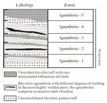
Advanced Search

Indexed by SCI、CA、РЖ、PA、CSA、ZR、etc .

2011 Vol. 22, No. 1

Display Method:
Research
Balanced cross-section and crustal shortening analysis in the Tanggula-Tuotuohe Area, Northern Tibet
Yalin LI, Chengshan WANG, Chao MA, Ganqing XU, Xixi ZHAO
2011, 22(1): 1-10. doi: 10.1007/s12583-011-0152-2
Abstract:
The Tanggula (唐古拉) thrust system and the Tuotuohe (沱沱河) foreland basin,which represent major Cenozoic tectonic units of the central Tibetan plateau,have been recently studied. Field investigation,analyses of deformation and construction of two restored balanced structural sections suggest 75–100 km (51%–64%) of N-S shortening in the Tanggula thrust system and 55–114 km (42%–47%) of N-S shortening in the Tuotuohe basin. The shortening ratios indicate that the Tanggula-Tuotuohe area has undergone intensive deformation and crustal shortening during the Early Tertiary,resulting not only in crustal thickening,but also in large scale volcanism and in rapid uplift of the Tanggula Mountains.
Distribution of Tuvaella brachiopod fauna and its tectonic significance
Chengwen WANG, Ning LI, Yuewu SUN, Pu ZONG
2011, 22(1): 11-19. doi: 10.1007/s12583-011-0153-1
Abstract:
Tuvaella brachiopod fauna are distributed in an arc in three areas, including the Zeya-Hailar (海拉尔)-Shinejinst area, the Najramdal Uul-Kyzyl area, and the Barkol-Fuyun (富蕴) area. The Tuvaella fauna in the Zeya-Hailar-Shinejinst area are distributed in the northern margin of Jiamusi (佳木斯)-Mongolia block along the Mongolia-Okhotsk suture between the Siberia plate and the Jiamusi-Mongolia block but not appear in the corresponding Siberia plate. The Tuvaella fauna in the Najramdal Uul-Kyzyl area are distributed in the southwestern part of the Siberia plate as the accelerated fold belts during the Salairian-Caledonian periods, and those in the Barkol-Fuyun area are distributed in the northeastern margin of Kazakhstan plate. They are distributed along the Irtysh suture between the Siberia plate and the Kazakhstan plate. The Tuvaella fauna became domestic fauna during the Wenlock and Pridoli (Middle-Late Silurian) and form a unique biogeographic province, i.e., the Mongolia-Okhotsk Province. This biogeographic province is sustained to the Mississippian (Carboniferous), perhaps due to the semiclosed state of the Mongolia-Okhotsk Ocean. The northeastern margin (right now the southwestern margin) of Siberia plate, the northern margin of Jiamusi-Mongolia block, and the northeastern margin of Kazakhstan plate might be conjuncted in an arc region from Wenlock to Mississippian, along the southern margin of the Irtysh-Mid Mongolia-Okhotsk Ocean. This is coincident with the fact that the Siberia plate rotated 180° clockwise since the Mesozoic and located in the middle-high latitude during Devonian, and the coral reef limestone is widely developed in the Jiamusi-Mongolia block during the Early and Middle Devonian, which suggests that the block was positioning in middle-lower latitude at that time and that the Kazakhstan plate was also located in low latitude then.
Silica-metal spherules in ignimbrites of southern Primorye, Russia
Andrei V. GREBENNIKOV
2011, 22(1): 20-31. doi: 10.1007/s12583-011-0154-0
Abstract:
A comprehensive mineralogical-geochemical and petrological study of ignimbrites from the Yakut-Gora volcanic depression (Primorye, Far Eastern Russia) revealed a wide distribution of silica-metal spherules ("globules") that are typical liquid immiscibility resultant. The metallic portion of a spherule (composition varies from low-carbon iron to cohenite) borders gas pores and is rimmed by symplectite that consists of quartz, magnetite, and silica-potassic glass. This allows us to consider that the whole formation formed through reduction of the enclosing silicate melt. Abundant evidence of high reduction states of ignimbrite melts and the presence of iron carbides suggest an H2-CH4 composition of the fluidal phase in ignimbrite magmas.
Experimental studies on seismic anisotropy enhanced by alignment of melt: Implication for the origin of abnormal anisotropy in Tibetan crust
Xiaosong YANG, Jianye CHEN, Yu YANG, Guoling ZHANG
2011, 22(1): 32-39. doi: 10.1007/s12583-011-0155-z
Abstract:
It is commonly agreed that seismic anisotropy, most likely caused by lattice preferred orientation (LPO) of major minerals, is a very important indicator of intracrustal deformation. Ultrasonic velocity measurements on the rocks from higher Himalayan crystallines (HHC) and Honghe (红河) strike-slip fault zone in Southwest China showed an average anisotropic magnitude of about 5%. However, a series of seismic measurements conducted in Tibet indicated marked anisotropy with a magnitude ranging from 8% to 18% within middle to lower crust. What causes the anomalously strong anisotropy within Tibetan crust? Parts of HHC rocks, to some extent, had undergone granulitic-grade metamorphism, the temperature and pressure of which were in excess of their solidus. Additionally, oriented leucocratic portions, which are accepted to be products crystallized from localized melt bands and aligned melt pocket (AMP), are present in HHC pervasively. If melt is oriented, it is expected to be an extremely important factor to influence anisotropy behavior. Experiments performed on analogue materials composed of plexiglass matrix and chocolate demonstrated that aligned melt could result in an extra anisotropy whose magnitude might increase two to three times. The contribution of AMP on anisotropy is likely comparable to or larger than that induced by LPO of major minerals, possibly amphiboles and micas, in middle to lower crust. It is implied that aligned melt may be a potential factor to induce anomalously strong anisotropy within Tibetan middle to lower crust.
Isotope geochemistry of volcanic rocks from the Barton Peninsula, King George Island, Antarctica
Jeong HWANG, Xiangshen ZHENG, Edward M. RIPLEY, Jong-Ik LEE, Dongbok SHIN
2011, 22(1): 40-51. doi: 10.1007/s12583-011-0156-y
Abstract:
C, O, H, S and Sr isotopes were investigated to characterize the isotopic composition of the Paleocene-Eocene volcanic rocks in Barton Peninsula, King George Island, Antarctica. The analyzed samples of volcanic rocks cover a range from basalt to andesite. The δ13C and δ18O values of calcite in volcanic rocks range from −7.5‰ to −3.2‰ and 0.4‰ to 5.1‰, respectively. The homogenous δ13Ccal and depleted δ18Ocal values relative to primary magmatic values reflect the effect of high temperature alteration of volcanic rocks. The δ18O of volcanic rocks ranges from −1.1‰ to 7.2‰, and the majority of values are significantly lower than those of primary magmatic values. The lowδ18OWR values are compatible with high temperature alteration. The initial values of 87Sr/86Sr of volcanic rocks span a narrow range from 0.703 312 to 0.703 504 which belong to the present mid-oceanic ridge basalt. The values of 87Sr/86Sr of volcanics in the Barton Peninsula are similar to those determined in the Fildes Peninsula, King George Island. The δDWR and H2O contents of volcanic rocks range from −74‰ to −66‰ and 0.67 wt.% to 2.74 wt.%, respectively. The higher δDWR and H2O wt.% of volcanic rocks relative to fresh basalts also result from high temperature alteration. Sulfur isotope compositions of the volcanic rocks range from −12.5‰ to −7.0‰; these values may represent fractionation accompanying partial oxidation of magmatic S or incorporation of some bacteriogenic sulfide. The low S contents and negative correlation with C and H2O reflect the formation of calcite and breakdown of sulfide as a result of high temperature water-rock interaction.
On the enigma of Nb-Ta and Zr-Hf fractionation—A critical review
Hui HUANG, Yaoling NIU, Zhidan ZHAO, Huixin HEI, Dicheng ZHU
2011, 22(1): 52-66. doi: 10.1007/s12583-011-0157-x
Abstract:
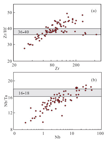
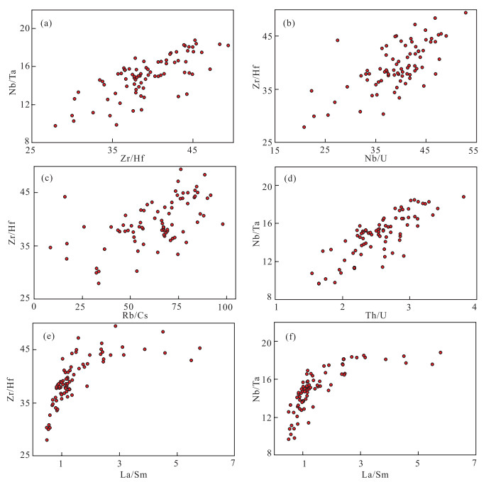
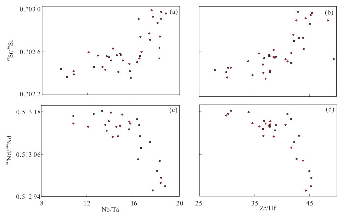
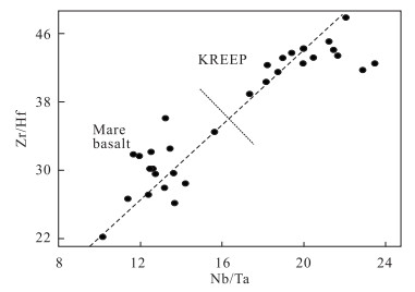
Elemental ratios Zr/Hf and Nb/Ta are expected to be constant and of chondritic value (~36.30 and ~17.57, respectively) in mantle and mantle-derived rocks. Studies in recent years have shown, however, that these two ratios do vary in some of these rocks. For example, MORB-like seamount lavas from flanks of the East Pacific Rise (EPR) show a correlated Zr/Hf (~25–50) and Nb/Ta (~9–18) variation. These two ratios are also correlated with ratios of more incompatible over less incompatible elements (e.g., La/Sm, Rb/Cs, Th/U, Nb/U, Sm/Yb) and with radiogenic isotope ratios (e.g., 87Sr/86Sr, 143Nd/144Nd). Furthermore, abyssal peridotites, which are melting residues for MORB, also show a huge correlated variation between Zr/Hf (~2.5–335) and Nb/Ta (~1–170). All these observations plus a correlated variation between Zr/Hf (~22–48) and Nb/Ta (~10–23) in lunar rocks are consistent with the Zr-Hf and Nb-Ta fractionation being of magmatic origin. This contrasts with the common view that geochemical processes cannot readily fractionate them. As charges and ionic radii are the principal factors in the general theory of elemental fractionation, this theory cannot explain the fractionation of these two element pairs with the same charges (i.e., 5+ for Nb and Ta, and 4+ for Zr and Hf) and essentially the same ionic size (i.e., RNb/RTa=1.000, RZr/RHf=1.006 to ~1.026 for coordination numbers of 6, 7, 8 and 12). We explore the possibilities of other factors and processes (e.g., mass-dependent fractionation during magmatism) that may cause the observed Nb-Ta and Zr-Hf fractionation. We emphasize that understanding the correlated Nb-Ta and Zr-Hf fractionation "known" to take place during magmatism is fundamental for improved understanding of elemental fractionations through other earth processes in various tectonic environments, including the origin and evolution of continental crust, which has a characteristic subchondritic Nb/Ta value of ~11-12.
Analysis of Onset and Development of Ore Formation in Dajishan Tungsten Ore Area, Jiangxi Province, China
Ningqiang Liu, Chongwen Yu
2011, 22(1): 67-74. doi: 10.1007/s12583-011-0158-9
Abstract:
The "theory of self-similar oscillatory finite-time singularities" of Sornette reflects accurately the spatio-temporal evolution and trends of development of events and processes in complex systems approaching to the singularities, and the effect of prediction for catastrophic events has been tested to be satisfactory. The authors take the contents of the chemical element tungsten as the carrier of positive feedback (or activator) in the ore formation, then try to apply the theory to studying and analyzing the onset and development of ore formation in the Dajishan (大吉山) tungsten ore area, Jiangxi (江西) Province, China. The results of the study show that during the spatio-temporal evolution from outside the ore area to its center, the contents of the chemical element tungsten and their logarithmic derivatives (local fractal dimension) manifest an obvious regularity: by way of the process of oscillation and the transition to power-law accelerating growth, they eventually approach the center of ore formation. The regularity makes clear that in the complex ore-forming system of the Dajishan tungsten ore deposit, the chemical element tungsten plays the role of carrier of positive and negative feedback, and by competing with each other, approaches to singularity in finite time by virtue of self-similar log-periodic oscillations and succeeded by power-law accelerating growth. In this way the onset of ore formation is realized. This regularity reflects correctly the dynamic process of ore formation of the studied ore deposit. The authors hold that Sornette's theory can be further applied to the prediction of perspective areas.
Structural and Tectonic Evolution of El-Faiyum Depression, North Western Desert, Egypt Based on Analysis of Landsat ETM+, and SRTM Data
Timothy M Kusky, Talaat M Ramadan, Mahmoud M Hassaan, Safwat Gabr
2011, 22(1): 75-100. doi: 10.1007/s12583-011-0159-8
Abstract:
False color Landsat ETM+ (bands 7, 4, 2 in RGB) and SRTM images of the El-Faiyum depression, Egypt, highlights major NE-SW faults and other lineaments trending NW-SE and N-S. Airborne magnetic data reveal some E-W subsurface faults which are not recognized on Landsat ETM+ and SRTM images. Ratio images (5/7, 3/1, 4/3) and (5/7, 5/1, 4) were used for lithological discrimination of different rock types. The El-Faiyum area is occupied by sedimentary rocks of Middle Eocene, Upper Eocene, Oligocene, Lower Miocene, Pliocene, Pleistocene and Holocene. Understanding the structural regime of El-Faiyum depression in the Western Desert of Egypt is significant in relation to the neotectonics of the Nile Delta and to the development of new communities west of the delta. The area is covered by Late Cretaceous, Middle to Late Eocene deposits, Oligocene deposits (comprising fluviatile sediments and basalt sheets) and Pliocene and Quaternary alluvium and sand deposits. New geological and structural maps were prepared at a scale of 1: 100 000 using Landsat ETM+ and SRTM images coupled with extensive field work. The major structural trends are E-W, ENE, NS and NW—the same trends observed elsewhere in North Africa from NW Sudan to NE Egypt including north and central Sinai. El-Faiyum depression is a structurally-controlled tectonic basin, marked by northeast-striking faults along its northern margin. These faults are parallel to similar faults of the Syrian arc fold belt, which includes a group of related faults, folds, push-up structures, and basins. Qarun Lake is located in the northern part of El-Faiyum depression, at a right-step between two strands of the NE striking fault system. We have suggested elsewhere that El-Faiyum depression is a pull-apart basin related to extension between these mismatched strands of strike-slip faults. The E-W structures are probably related to the relative motion between south Europe and north Egypt and closure of the Neotethys. The continuation of these faults in the present area is only detected from magnetic and seismic studies. The question that needs to be raised is why these old structural features have been reactivated in recent times. Thus, the presence of these fault zones must be heeded in all development plans for El-Faiyum region.
Primary Intergranular Pores in Oolitic Shoal Reservoir of Lower Triassic Feixianguan Formation, Sichuan Basin, Southwest China: Fundamental for Reservoir Formation and Retention Diagenesis
Xiucheng Tan, Hong Liu, Ling Li, Bing Luo, Xiaoguang Liu, Xiaohui Mou, Yong Nie, Wenyan Xi
2011, 22(1): 101-114. doi: 10.1007/s12583-011-0160-2
Abstract:
The Lower Triassic Feixianguan (飞仙关) Formation oolitic shoal reservoir in the Sichuan (四川) basin (Southwest China) is currently an exploration and research highlight in China. The reservoir is widely believed to be formed mainly by burial dissolution and/or dolomitization on the basis of primary intergranular pores. In this study, through a comprehensive geological study on the whole basin, the dissolution and dolomitization are suggested not to be the fundamental factor of reservoir formation and there thus may be a possible new fundamental mechanism—the preservation of primary intergranular pores, i.e., the retention diagenesis. Based on this, a complex and multi-stage reservoir evolution and formation model is proposed. In the model, the depositional environment is the basis of reservoir initial formation. Subsequently, early compaction and shallow burial cementation result in the primary reservoir differentiation. Then, multi-stage burial dissolution alters and adjusts the reservoir. Because the last stage gaseous hydrocarbons have little diagenetic impact, the reservoir is formed finally. Therefore, this study presents a possible new fundamental mechanism and evolution model for the reservoir formation. The results can be applied in the regional reservoir predication and shaping exploration strategies, and provide reference for the study of shoal reservoirs in other areas.
Why are Q-Ratios High in the Sulu UHP Metamorphic Rocks?
Qingsheng Liu
2011, 22(1): 115-116. doi: 10.1007/s12583-011-0161-1
Abstract:
Rayleigh Wave Group Velocity Distribution in Ningxia
Hongyi LI, Xin LIU, Xinfu LI, Juqin SHENG, Xinhua CAI, Tongli WANG
2011, 22(1): 117-123. doi: 10.1007/s12583-011-0162-0
Abstract:
In this article, seven months ambient noise data and 10 events recorded at seven digital stations from the Ningxia (宁夏) regional seismic network and 5 500-t controlled source explosion data recorded by 15 temporary and 7 permanent seismic stations are used to measure dispersion curves of fundamental mode Rayleigh waves. The study region was divided into grids with 0.1°×0.1°; group velocity distributions of Rayleigh waves from 6–22 s were determined with the Occam's inversion technique. These velocity distribution maps show the lateral velocity variations in the study area, and the velocity structures are correlated with surface geology and tectonic units. The Yinchuan (银川) basin is clearly featured with low velocities, and the Helan (贺兰) Mountain and southern mountain areas are revealed with high velocities.
2.5-D DC Resistivity Modeling Considering Flexibility and Accuracy
Jingtian Tang, Feiyan Wang, Xiao Xiao, Lincheng Zhang
2011, 22(1): 124-130. doi: 10.1007/s12583-011-0163-z
Abstract:
We highlighted the flexibility of using unstructured mesh together with the local refinement by a resistivity model with complicated topography. The effect of topography is emphasized. Based on this, we calculated a specific class of layered models and found that the accuracy is not always satisfactory by utilizing the standard approach. As an improvement, we employed the layered earth as the reference model to calculate the wavenumbers. The comparison demonstrates that the accuracy is considerably improved by using this enhanced approach.