Advanced Search

Indexed by SCI、CA、РЖ、PA、CSA、ZR、etc .

2009 Vol. 20, No. 1

Display Method:
Research
Tectonics and Sedimentary Basins of the South China Sea: Challenges and Progresses
Di Zhou, Bochu Yao
2009, 20(1): 1-12. doi: 10.1007/s12583-009-0001-8
Abstract:
Crustal Structure beneath Yinggehai Basin and Adjacent Hainan Island, and Its Tectonic Implications
Shimin Wu, Xuelin Qiu, Di Zhou, Gangping Zeng, Kanyuan Xia, Sanyu Ye
2009, 20(1): 13-26. doi: 10.1007/s12583-009-0002-7
Abstract:

Two NE-SW trending wide-angle seismic profiles were surveyed across the Chinese side of the Yinggehai (莺歌海) basin (YGHB) with ocean bottom hydrophones (OBHs) and piggyback recorded by onshore stations located on the Hainan (海南) Island. Detailed velocity-depth models were obtained through traveltime modeling and partially constrained by amplitude calculations. More than 15 km Tertiary sedimentary infill within the YGHB can be divided in to three layers with distinct velocity-depth distribution. Overall, the upper layer has a high velocity gradient with 3.8–4.1 km/s at its bottom, consistent with progressive compaction and diagenesis. Its thickness increases gradually towards the basin center, reaching 4.5 km along the southern profile. The middle layer is characterized in its most part as a pronounced low velocity zone (LVZ) with average velocity as low as 3.0 km/s. Its thickness increases from 3.0 to over 4.5 km from NW towards SE. The primary causes of the velocity inversion are high accumulation rate and subsequent under-compaction of sediments. The velocity at the top of the lower layer is estimated at about 4.5 km/s. Despite strong energy source used (4 × 12L airgun array), no reflections can be observed from deeper levels within the basin. Towards NE the basin is bounded sharply by a clear and deep basement fault (Fault No. 1), which seems to cut through the entire crust. A typical continental crust with low-velocity middle crust is found beneath the coast of the western Hainan Island. Its thickness is determined to be 28 km and shows no sign of crustal thinning towards the basin. The sharp change in crustal structure across Fault No. 1 indicates that the fault is a strike-slip fault. The crustal structure obtained in this study clearly favors the hypothesis that the YGHB is a narrow pull-apart basin formed by strike-slip faulting of the Red River fault zone.

Crustal Structure and Extension from Slope to Deepsea Basin in the Northern South China Sea
Dengke Hu, Di Zhou, Xiangjie Wu, Min He, Xiong Pang, Yuwei Wang
2009, 20(1): 27-37. doi: 10.1007/s12583-009-0003-6
Abstract:

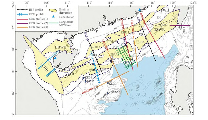
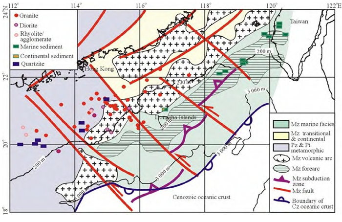
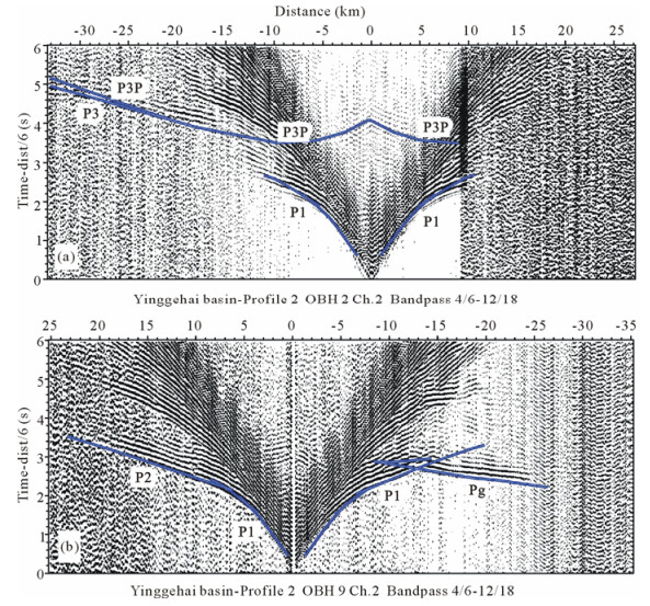
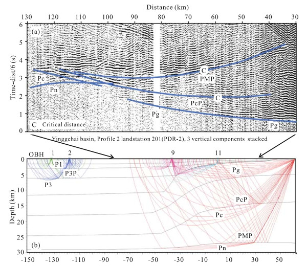
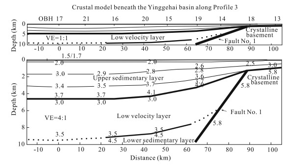
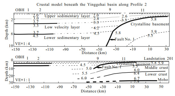
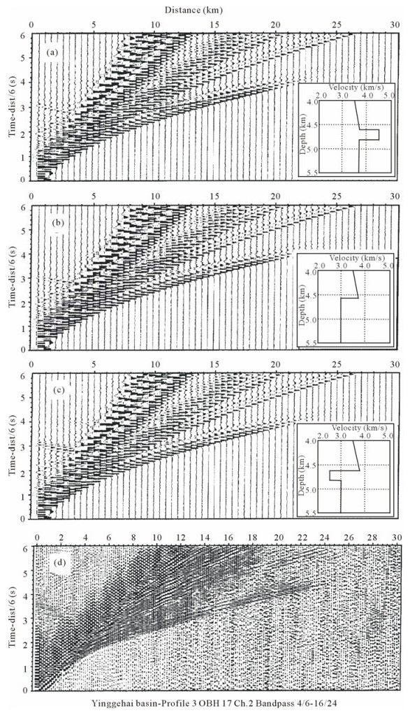
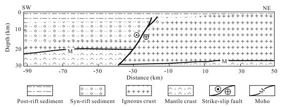
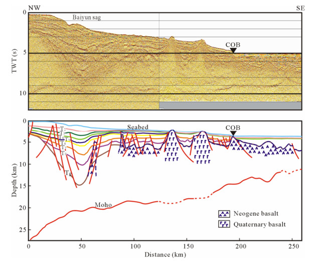
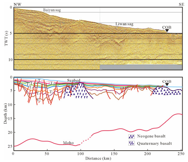
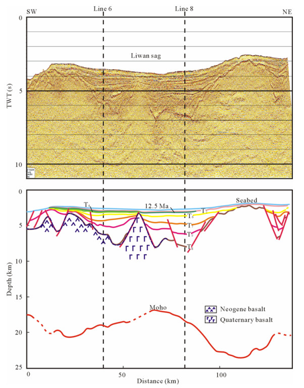
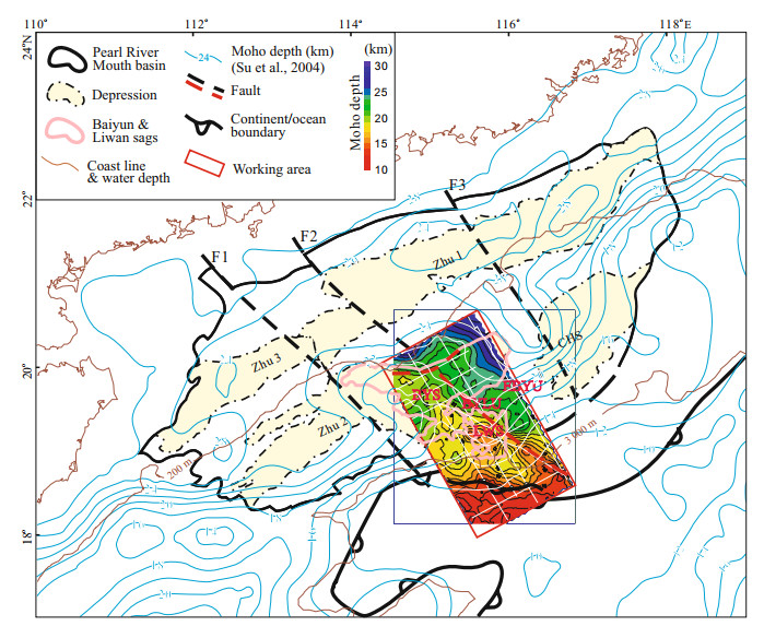
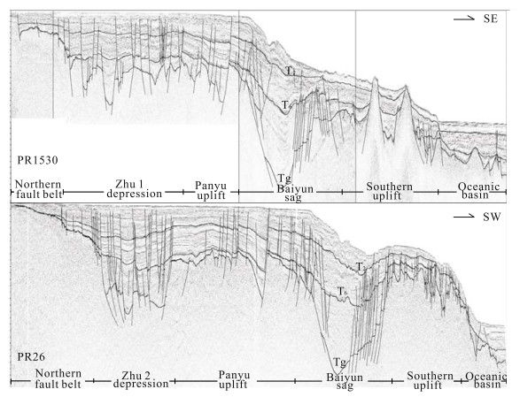
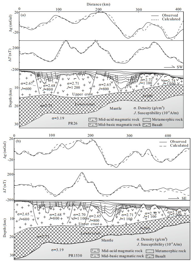
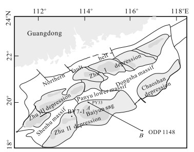
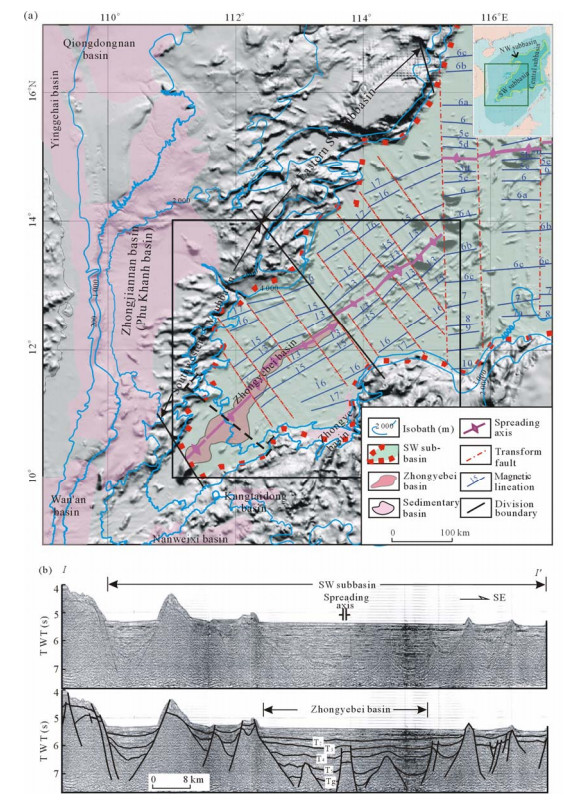
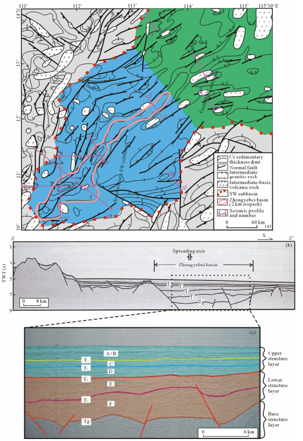
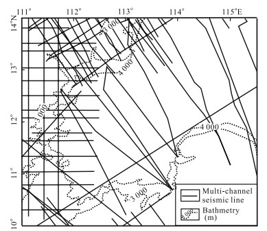
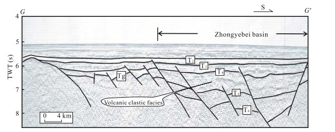
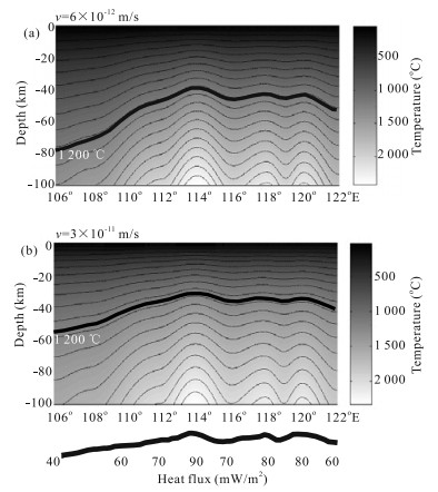
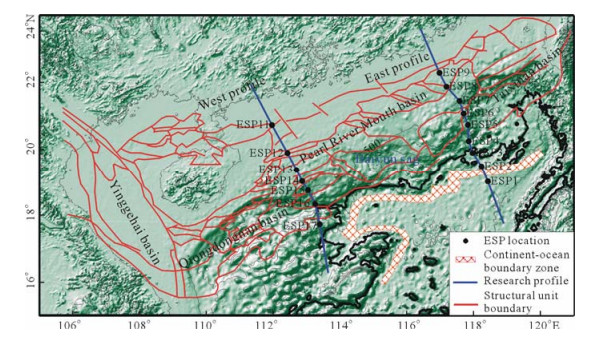
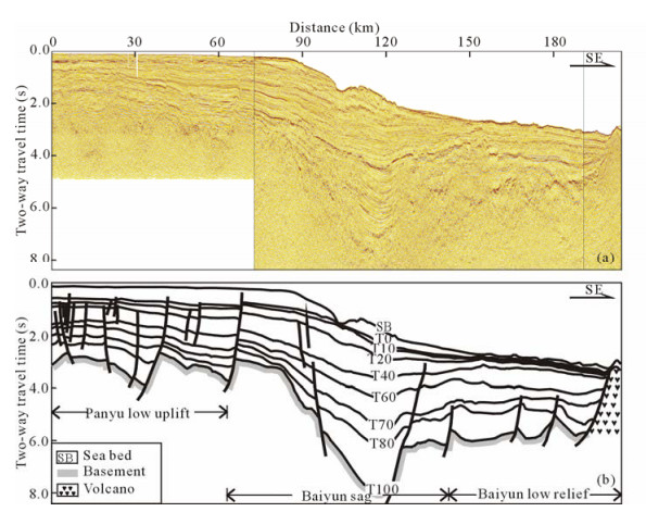
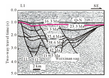
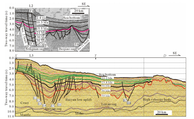
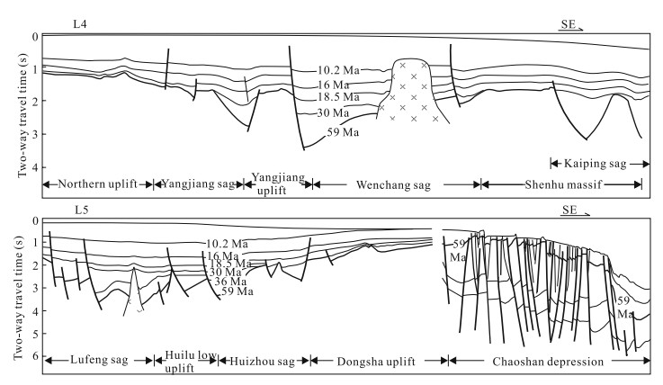
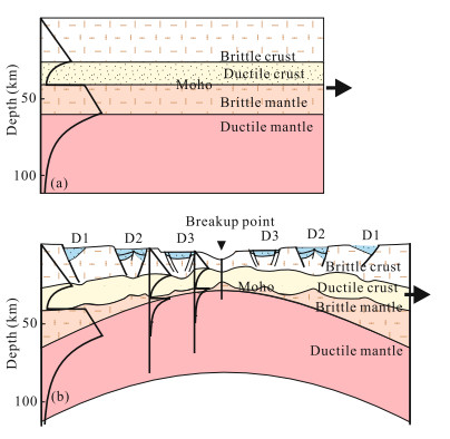
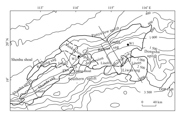
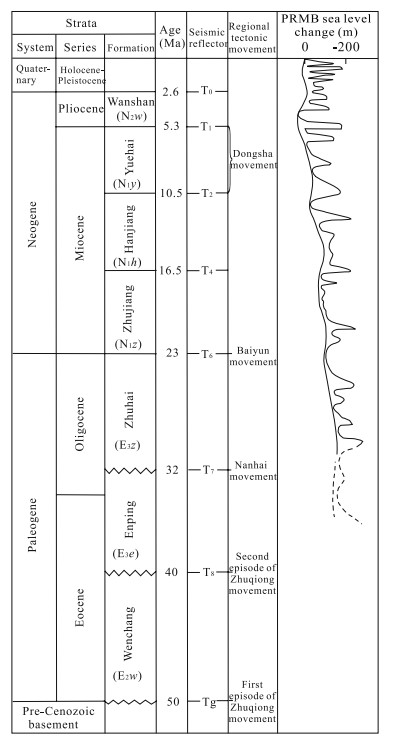
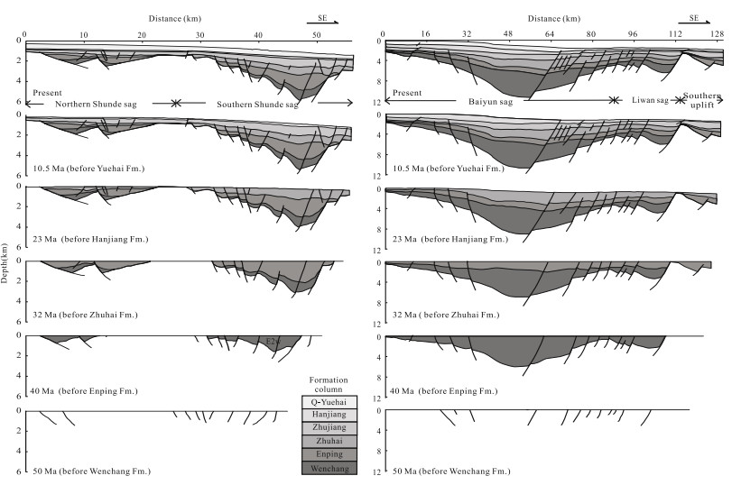
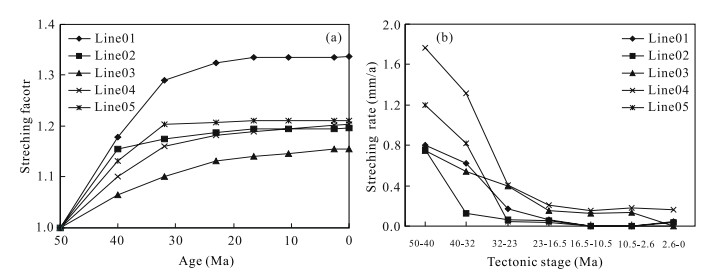
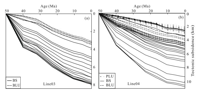
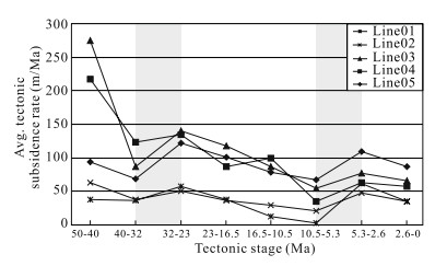
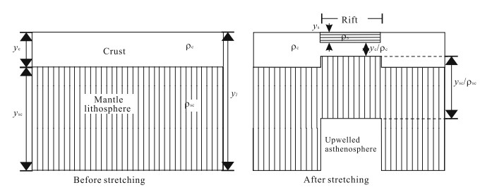
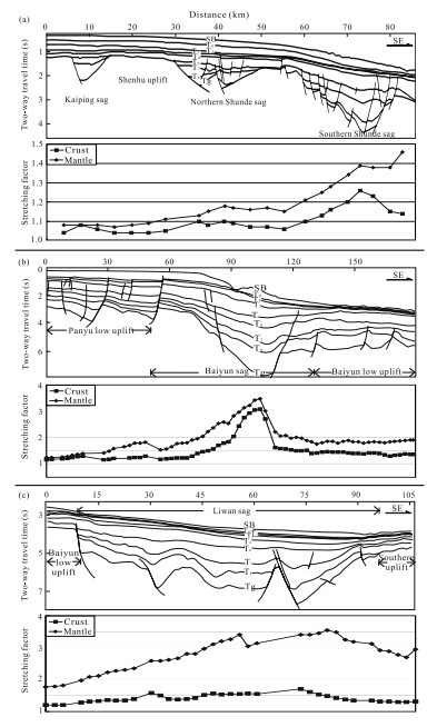
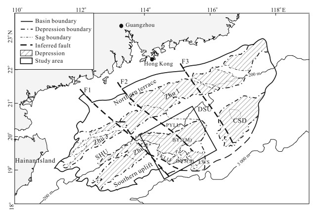
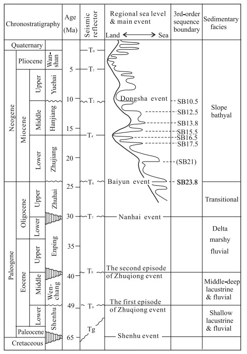
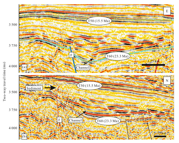
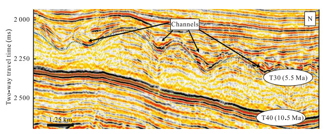
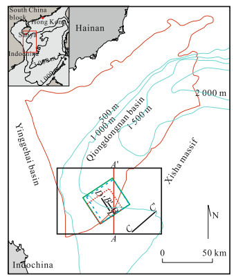
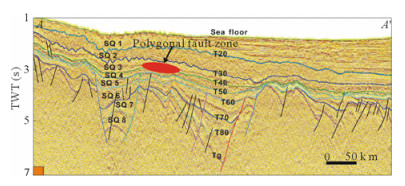
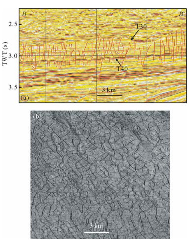
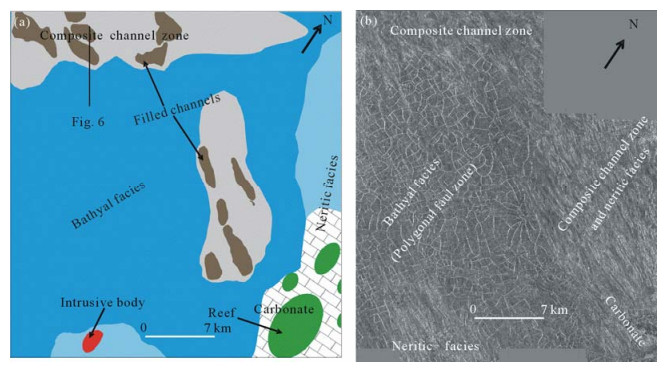
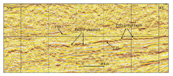
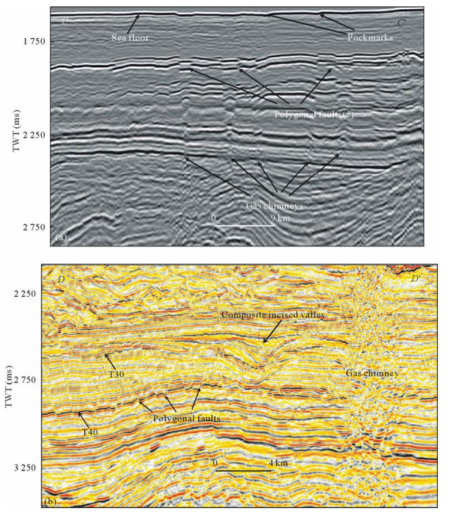
The newly acquired long-cable multi-channel seismic (MCS) lines were used to study the crustal structure and extension in an NW-SE elongated 150 km by 260 km strip from the slope to the deepsea basin in the northern South China Sea (SCS). These profiles are of good penetration that Moho is recognizable in ~70% length of the lines. Seismostratigraphic interpretation and time-depth conversion were conducted. A power function D = atb + c was used in the time-depth conversion, which avoided the under- or over-estimation of the depths of deep-seated interfaces by cubic or quadratic polynomial functions. Contour maps of basement depth, Moho depth, crustal thickness, and crustal stretching factor were obtained for the study area. In the dip direction, the Moho depth decreases stepwisely from 28 km in the outer shelf southwards to 19, 15, and 12 km in the deepsea basin, with ramps at the shelf break, lower slope, and the continent ocean boundary (COB), respectively. Accordingly, the crustal thickness decreased southwards from 25 to 15, 13, and 7 km, respectively. Under the center of the Baiyun (白云) sag, the crust thins significantly to < 7 km. The crustal stretching factor βc was calculated by assuming the original crust thickness of 30 km. In the centers of the Baiyun sag, βc exceeds 5. Tertiary and Quaternary volcanic activities show a general trend of intensifying towards the COB. An important finding of this study is the along-strike variation of the crustal structure. A Moho rise extends from the COB NW-ward until the shelf break, about 170 km long and 50–100 km wide, with Moho depth < 20 km. This is called the Baiyun Moho Nose, which is bounded to the east, west, and north by belts of high Moho gradients indicative of crustal or even lithospheric faults. The doming of Moho in the nose area might be the cause of the W-E segmentation of the crustal and geological structures along the slope of the northern South China Sea, and the cause of the strong crustal stretching in the Baiyun and Liwan (荔湾) sags.

Deep Structure and Dynamics of Passive Continental Margin from Shelf to Ocean of the Northern South China Sea
Xiangjie Wu, Xiong Pang, Hesheng Shi, Min He, Jun Shen, Xiangtao Zhang, Dengke Hu
2009, 20(1): 38-48. doi: 10.1007/s12583-009-0004-5
Abstract:

To study the deep dynamic mechanism leading to the difference in rifting pattern and basin structure from shelf to oceanic basin in passive continental margin, we constructed long geological sections across the shelf, slope and oceanic basin using new seismic data. Integrated gravity-magnetic inversion and interpretation of these sections were made with the advanced dissection method. Results show that the basement composition changes from intermediate-acid intrusive rocks in the shelf to intermediate-basic rocks in the slope. The Moho surface shoals gradually from 31 km in the shelf to 22.5 km in the uplift and then 19 km in the slope and finally to 13 km in the oceanic basin. The crust thickness also decreases gradually from 30 km in the northern fault belt to 9 km in the oceanic basin. The crustal stretching factor increases from the shelf toward the oceanic basin, with the strongest extension under the sags and the oceanic basin. The intensity of mantle upwelling controlled the style of basin structures from shelf to oceanic basin. In the Zhu 1 depression on the shelf, the crust is nearly normal, the brittle and cold upper crust mainly controlled the fault development; so the combinative grabens with single symmetric graben are characteristic. In the slope, the crust thinned with a large stretching factor, affected by the mantle upwelling. The ductile deformation controlled the faults, so there developed an asymmetric complex graben in the Baiyun (白云) sag.

Baiyun Movement: A Significant Tectonic Event on Oligocene/Miocene Boundary in the Northern South China Sea and Its Regional Implications
Xiong Pang, Changmin Chen, Ming Zhu, Min He, Jun Shen, Shiyong Lian, Xiangjie Wu, Lei Shao
2009, 20(1): 49-56. doi: 10.1007/s12583-009-0005-4
Abstract:

A significant geologic event occurred on the Oligocene/Miocene boundary at 23.8 Ma in the northern South China Sea, which is named the Baiyun (白云) movement in this article. This event strongly affected not only the South China Sea, but also East Asia. After the Baiyun event, the ridge of seafloor spreading of the South China Sea jumped southward and rotated counterclockwise, and a strong subsidence occurred in the Baiyun sag of the Pearl River Mouth basin. The shelf break shifted suddenly from the south to the north of the Baiyun sag, and the deposition environment in this sag changed from continental shelf with neritic deposition to continental slope with deep-water deposition. Sediment geochemistry study indicated that the Baiyun event played a key role in the rapid change of sediment provenance for the Pearl River Mouth basin. Between 32 and 23.8 Ma, the source of sediments was mainly from the granites in South China, while after 23.8 Ma some sediments might have come from the eastern Himalaya, as the Pearl River drainage extended westward after the uplift of Tibet since that time. The Baiyun event led to a great change in the drainage framework of the paleo-Pearl River, sediment types and the depositional environments in the Pearl River Mouth basin, and relative sea level of the northern South China Sea, as well as sedimentation and hydrocarbon accumulation in the area.

Denudation History of South China Block and Sediment Supply to Northern Margin of the South China Sea
Yi Yan, Xiaoqiong Hu, Ge Lin, Bin Xia, Xiaoyong Li, Remesh Chandra Patel
2009, 20(1): 57-65. doi: 10.1007/s12583-009-0006-3
Abstract:

On the basis of apatite fission track (AFT) analyses, this article aims to provide a quantitative overview of Cenozoic morphotectonic evolution and sediment supply to the northern margin of the South China Sea (SCS). Seventeen granite samples were collected from the coast to the inland of the South China block. Plots of AFT age against sample location with respect to the coastline show a general trend of youngling age away from the coast, which implies more prolonged erosion and sediment contribution at the inland of the South China Sea during post break-up evolution. Two-stage fast erosion process, Early Tertiary and Middle Miocene, is deduced from simulated cooling histories. The first fast cooling and denudation during Early Tertiary are recorded by the samples along the coast (between 70 and 60 Ma) and the inland (between 50 and 30 Ma), respectively. This suggests initial local erosion and deposition in the northern margin of the SCS during Early Tertiary. Fast erosion along the coast ceased since ca. 50 Ma, while it had lasted until ca. 30 Ma inland, indicating that the erosion was transferred from the local coastal zone initially toward the continental interior with unified subsidence of the northern margin, which resulted in the formation of a south-dipping topography of the continental margin. The thermal stasis in the South China block since ca. 30 Ma must define the time at which the northern margin became dynamically disconnected from the active rifting and stretching that was taking place to the south. The lower erosion rate is inconsistent with higher sedimentary rate in the Pearl River Mouth basin during Late Oligocene (ca. 25 Ma). This indicates that the increased sedimentation in the basin is not due to the erosion of the granite belt of the South China block, but perhaps points to the westward propagation of the paleo-Pearl River drainage related to the uplift of the eastern margin of Tibet plateau and southward jumping of spreading axis of the South China Sea. The second erosion acceleration rate of the Middle Miocene (ca. 14 Ma) cooling could have been linked to the long-distance effect of uplift of the Tibet plateau or due to the enhanced East Asian monsoon.

Relationship between Formation of Zhongyebei Basin and Spreading of Southwest Subbasin, South China Sea
Hongfang Gao, Di Zhou, Yan Qiu
2009, 20(1): 66-76. doi: 10.1007/s12583-009-0007-2
Abstract:

The Zhongyebei (中业北) basin (ZYBB) is an NE-striking, narrow and small sedimentary basin superimposing the southern 1/2 segment of the proposed spreading axes of the SW subbasin of the South China Sea (SCS). More than 4 500 m strata were identified in the Zhongyebei basin, including the Paleogene lower structure layer and the Neogene upper structure layer. The SW subbasin of the South China Sea has been regarded as an oceanic basin opened by seafloor spreading, as evidenced by the flat and deep (> 4 000 m mostly) seafloor with linear magnetic anomalies, and by the shallow Moho depth of < 12 km as estimated from gravity modeling. The classic model of seafloor spreading predicts that sediments on the oceanic crust are younger and thinner towards the spreading axes. But in the southwestern segment of the SW subbasin, contradictions appear. Firstly, the thick sedimentation in the ZYBB is along the proposed spreading axes. Secondly, the sediments are thinner (500–1 500 m) and younger away from the proposed spreading axes. Thirdly, geological elements of the two sides of spreading axes develop asymmetrically in the southwestern SW subbasin. Two models, the early opening model and the limited modeling model, are suggested for resolving this paradox. The former suggests that the opening of the SW subbasin was in Late Eocene and earlier than the oldest sediment in the ZYBB. The latter proposes that the opening of the SW subbasin was limited to its northeastern portion, and did not extend to the southwest portion. The ZYBB is a rift basin survived from the spreading but subjected to severe syn-spreading magmatic disturbance. The SW subbasin and the ZYBB of the SCS provide a unique opportunity for studying the structural evolution and dynamic mechanism at the tip of a propagating seafloor spreading. Both models have unresolved questions, and further studies are needed.

Links among Slope Morphology, Canyon Types and Tectonics on Passive and Active Margins in the Northernmost South China Sea
Ho-Shing Yu, Emmy T Y Chang
2009, 20(1): 77-84. doi: 10.1007/s12583-009-0008-1
Abstract:

We examine slope profile types and variations in slope gradient and slope relief with depth for both passive and active margins in the northern most South China Sea. The passive South China margin is characterized by an exponential slope profile, mainly associated with clustered slope-confined canyons. The active Taiwan margin shows a linear-like shape with great variations along the lower slope. Fewer canyons occur on the Taiwan margin, and hence the influence of canyon incision on slope morphology is relatively less significant. Quantitative analyses of slope curvature, slope gradient and square root of relief variance are useful statistical parameters to explain characteristics and variability of morphology of the slope of the South China margin, but not for the Kaoping slope on the Taiwan side. On the active Taiwan margin, tectonic activities are dominant over sediment deposition and surface erosion, producing a slope profile quite different from those of passive margins of the Middle Atlantic, KwaZulu-Natal, South Africa where failure on slope and accompanying canyon incision are the dominant processes shaping the slope morphology.

Numerical Analysis and Simulation Experiment of Lithospheric Thermal Structures in the South China Sea and the Western Pacific
Ge Lin, Meili Peng, Chongbin Zhao, Lu Zhang, Desheng Zhang, Shilin Liu
2009, 20(1): 85-94. doi: 10.1007/s12583-009-0009-0
Abstract:

The asthenosphere upwelled on a large scale in the western Pacific and South China Sea during the Cenozoic, which formed strong upward throughflow and caused the thermal structure to be changed obviously. The mathematical analysis has demonstrated that the upward throughflow velocity may have varied from 3×10¹¹ to 6×10¹² m/s. From the relationship between the lithospheric thickness and the conductive heat flux, the lithospheric heat flux in the western Pacific should be above 30 mW/m2, which is consistent with the observed data. The huge low-speed zone within the upper mantle of the marginal sea in the western Pacific reflects that the upper mantle melts partially, flows regionally in the regional stress field, forms the upward heat flux at its bottom, and causes the change of the lithospheric thermal structure in the region. The numerical simulation result of the expansion and evolution in the South China Sea has demonstrated that in the early expansion, the upward throughflow velocity was relatively fast, and the effect that it had on the thickness of the lithosphere was relatively great, resulting in the mid-ocean basin expanding rapidly. After the formation of the ocean basin in the South China Sea, the upward throughflow velocity decreased, but the conductive heat flux was relatively high, which is close to the actual situation. Therefore, from the heat transfer point of view, this article discusses how the upward heat flux affects the lithospheric thermal structure in the western Pacific and South China Sea. The conclusions show that the upward heat throughflow at the bottom of the lithospheric mantle resulted in the tectonic deformation at the shallow crust. The intensive uplifts and rifts at the crust led to the continent cracks and the expansion in the South China Sea.

Lithospheric Thermal Isostasy of North Continental Margin of the South China Sea
Shi Chen, Jian Zhang, Yujun Sun, Yaolin Shi
2009, 20(1): 95-106. doi: 10.1007/s12583-009-0010-7
Abstract:

Accompanied with rifting and detaching of the north continental margin of the South China Sea, the crust and the lithosphere become thinner away from the continental margin resulting from the tectonic activities, such as tensile deformation, thermal uplift, and cooling subsidence, etc.. Integrated with thermal, gravimetric, and isostatic analysis techniques, based on the seismic interpretation of the deep penetration seismic soundings across the northern margin of the South China Sea, we reconstructed the lithospheric thermal structure and derived the variation of the crust boundary in the east and west parts of the seismic profile by using gravity anomaly data. We mainly studied the thermal isostasy problems using the bathymetry of the profiles and calculated the crust thinning effect due to the thermal variety in the rifting process. The results indicate that the thermal isostasy may reach 2.5 km, and the compositional variations in the lithospheric density and thickness may produce a variation of 4.0 km. Therefore, the compositional isostatic correction is very important to recover the relationship between surface heat flow and topography. Moreover, because of the high heat flow characteristic of the continental margin, building the model of lithospheric geotherm in this region is of great importan for studying the Cenozoic tectonic thermal evolution of the north passive continental margin of the South China Sea.

Kinematics of Convergence and Deformation in Luzon Island and Adjacent Sea Areas: 2-D Finite-Element Simulation
Zaifeng Liu, Wenhuan Zhan, Yantao Yao, Meizhen Zhan, Dianguang Zhang
2009, 20(1): 107-116. doi: 10.1007/s12583-009-0012-3
Abstract:

The Luzon Island is a volcanic arc sandwiched by the eastward subducting South China Sea and the northwestward subducting Philippine Sea plate. Through experiments of plane-stress, elastic, and 2-dimensional finite-element modeling, we evaluated the relationship between plate kinematics and present-day deformation of Luzon Island and adjacent sea areas. The concept of coupling rate was applied to define the boundary velocities along the subduction zones. The distribution of velocity fields calculated in our models was compared with the velocity field revealed by recent geodetic (GPS) observations. The best model was obtained that accounts for the observed velocity field within the limits of acceptable mechanical parameters and reasonable boundary conditions. Sensitivity of the selection of parameters and boundary conditions were evaluated. The model is sensitive to the direction of convergence between the South China Sea and the Philippine Sea plates, and to different coupling rates in the Manila trench, Philippine trench and eastern Luzon trough. We suggest that a change of ±15° of the direction of motion of the Philippine Sea plate can induce important changes in the distribution of the computed displacement trajectories, and the movement of the Philippine Sea plate toward azimuth 330° best explains the velocity pattern observed in Luzon Island. In addition, through sensitivity analysis we conclude that the coupling rate in the Manila trench is much smaller compared with the rates in the eastern Luzon trough and the Philippine trench. This indicates that a significant part of momentum of the Philippine Sea plate motion has been absorbed by the Manila trench; whereas, a part of the momentum has been transmitted into Luzon Island through the eastern Luzon trough and the Philippine trench.

Characteristics and Hydrocarbon Potential of Mesozoic Strata in Eastern Pearl River Mouth Basin, Northern South China Sea
Hujun Hao, Xiangtao Zhang, Hongqing You, Ruiliang Wang
2009, 20(1): 117-123. doi: 10.1007/s12583-009-0013-4
Abstract:

The well LF35-1-1 in the eastern Pearl River Mouth basin (PRMB) of the northern South China Sea revealed unmetamorphosed Middle-Late Jurassic neritic-bathyal sediments and Cretaceous fluvial-lacustrine sediments. Three tectonic movements were identified in Late Jurassic to Early Cretaceous, late Early Cretaceous, and Late Cretaceous to Paleocene, respectively. The Late Jurassic marine facies mainly contain the hydrocarbon source and reservoir-seal assemblages, providing a main exploration target.

Petroleum System in Deepwater Basins of the Northern South China Sea
Shiguo Wu, Qinghua Han, Yubo Ma, Dongdong Dong, Fuliang Lü
2009, 20(1): 124-135. doi: 10.1007/s12583-009-0014-3
Abstract:

The northern South China Sea margin has experienced a rifting stage and a post-rifting stage during the Cenozoic. In the rifting stage, the margin received lacustrine and shallow marine facies sediments. In the post-rifting thermal subsidence, the margin accumulated shallow marine facies and hemipelagic deposits, and the deepwater basins formed. Petroleum systems of deepwater setting have been imaged from seismic data and drill wells. Two kinds of source rocks including Paleogene lacustrine black shale and Oligocene-Early Miocene mudstone were developed in the deepwater basin of the South China Sea. The deepwater reservoirs are characterized by the deep sea channel fill, mass flow complexes and drowned reef carbonate platform. Profitable capping rocks on the top are mudstones with huge thickness in the post-rifting stage. Meanwhile, the faults developed during the rifting stage provide a migration path favourable for the formation of reservoirs. The analysis of seismic and drilling data suggests that the joint structural and stratigraphic traps could form giant hydrocarbon fields and hydrocarbon reservoirs including syn-rifting graben subaqueous delta, deepwater submarine fan sandstone and reef carbonate reservoirs.

Patterns and Dynamics of Rifting on Passive Continental Margin from Shelf to Slope of the Northern South China Sea: Evidence from 3D Analogue Modeling
Zhen Sun, Di Zhou, Shimin Wu, Zhihong Zhong, Keep Myra, Jianqun Jiang, Hao Fan
2009, 20(1): 136-146. doi: 10.1007/s12583-009-0011-6
Abstract:

Affected by thermal perturbation due to mantle uprising, the rheological structure of the lithosphere could be modified, which could lead to different rifting patterns from shelf to slope in a passive continental margin. From the observed deformation style on the northern South China Sea and analogue modeling experiments, we find that the rift zone located on the shelf is characterized by half grabens or simple grabens controlled mainly by long faults with large vertical offset, supposed to be formed with normal lithosphere extension. On the slope, where the lithosphere is very hot due to mantle upwelling and heating, composite grabens composed of symmetric grabens developed. The boundary and inner faults are all short with small vertical offset. Between the zones with very hot and normal lithosphere, composite half grabens composed of half grabens or asymmetric grabens formed, whose boundary faults are long with large vertical offset, while the inner faults are relatively short. Along with the thickness decrease of the brittle upper crust due to high temperature, the deformation becomes more sensitive to the shape of a pre-existing weakness zone and shows orientation variation along strike. When there was a bend in the pre-existing weakness zone, and the basal plate was pulled by a clockwise rotating stress, the strongest deformation always occurs along the middle segment and at the transition area from the middle to the eastern segments, which contributes to a hotter lithosphere in the middle segment, where the Baiyun (白云) sag formed.

Tectonic Evolution and Dynamics of Deepwater Area of Pearl River Mouth Basin, Northern South China Sea
Dongdong Dong, Gongcheng Zhang, Kai Zhong, Shengqiang Yuan, Shiguo Wu
2009, 20(1): 147-159. doi: 10.1007/s12583-009-0016-1
Abstract:

Quantitative studies on the evolution and dynamics of the deepwater area of Pearl River Mouth basin (PRMB) were carried out based on the latest geological and seismic data. The study area is generally in an extensional state during the Cenozoic. The major extension happened in the earlier syn-rift stages before 23 Ma and the extension after 23 Ma is negligible. Two rapid subsidence periods, 32–23 Ma and 5.3–2.6 Ma, are identified, which are related to the abrupt heat decay during margin breakup and the collision between the Philippine Sea plate and the Eurasian plate, respectively. The strongest crustal thinning in the Baiyun (白云) sag may trigger the syn-rift volcanism along the weak faulted belt around the sag. The Cenozoic tectonic evolution of the study area could be divided into five stages: rifting (~50–40 Ma), rift-drift transition (~40–32 Ma), early post-breakup (~32–23 Ma), thermal subsidence (~23–5.3 Ma) and neotectonic movement (~5.3–0 Ma).

Filling History and Post-Breakup Acceleration of Sedimentation in Baiyun Sag, Deepwater Northern South China Sea
Di Zhou, Zhen Sun, Jie Liao, Zhongxian Zhao, Min He, Xiangjie Wu, Xiong Pang
2009, 20(1): 160-171. doi: 10.1007/s12583-009-0015-2
Abstract:

The Baiyun (白云) sag in the southern Pearl River Mouth basin is the largest and deepest sag in deepwater northern South China Sea. Researches and exploration in this sag have revealed many distinct features of the sag. This article reports its filling history through backstripping of depth data of interpreted sequence boundaries. Maps of sediment rates of 10 sequences from 49 Ma to the present were constructed, showing the spatio-temporal variation of the sediment rate. Three stages of sediment infilling, 49–17.5 Ma, 17.5–10.5 Ma, and 10.5–0 Ma, were divided by abrupt changes of sedimentary patterns. If the breakup of the South China Sea took place at ~30 Ma, significant post-breakup acceleration of sedimentation was observed at 17.5–15.5 Ma and 13.8–12.5 Ma, indicating acceleration of subsidence at these times. We propose that the onset of strong post-breakup subsidence at ~17.5 Ma was an important tectonic event that changed the pattern of sedimentation from discrete and medium-rate deposition centers in both main and south subsags to restricted but high-rate deposition in the main subsag. The cause and implications of this newly recognized event need to be investigated.

Features of Late Cenozoic Deepwater Sedimentation in Southern Qiongdongnan Basin, Northwestern South China Sea
Shengqiang Yuan, Genshun Yao, Fuliang Lü, Bing Hu, Xiaosu He, Bin Wang, Li Li
2009, 20(1): 172-179. doi: 10.1007/s12583-009-0017-0
Abstract:

Based on high resolution 2D and 3D seismic data acquired in recent years, using sequence stratigraphy analysis and geophysical methods, we discuss the features of Late Cenozoic deepwater sedimentation in the southern Qiongdongnan (琼东南) basin. The study area entered a bathyal slope environment in the Miocene. The channel developed in the Sanya (三亚) Formation was controlled by a fault break, and its shingled seismic characteristics represent multiple erosion and fill, which may indicate that turbidite current developed in the slope environment. The polygon faults found in mudstone of the Meishan (梅山) Formation represent the deepwater hungry sedimentary environment. The large-scale channels developed on the top of Huangliu (黄流) Formation could be the result of a big sea level drop and an increase of sediment supply. The fantastic turbidite channel developed in Late Quaternary in the slope environment has "fan-like" body and long frontal tiny avulsion channel. The analysis of these features suggests that the sediment supply of the study area in the post-rifting period was dominant from the Vietnam uplift in the southwest. These deepwater sedimentary features could be potential reservoirs or migration pathways for deepwater petroleum systems.

Characteristics and Formation Mechanism of Polygonal Faults in Qiongdongnan Basin, Northern South China Sea
Qiliang Sun, Shiguo Wu, Genshun Yao, Fuliang Lü
2009, 20(1): 180-192. doi: 10.1007/s12583-009-0018-z
Abstract:

Based on high-resolution 3D seismic data, we document the polygonal faults within the Miocene Meishan (梅山) Formation and Huangliu (黄流) Formation of the Qiongdongnan (琼东南) basin, northern South China Sea. Within the seismic section and time coherent slice, densely distributed extensional faults with small throw and polygonal shape were identified in map view. The orientation of the polygonal faults is almost isotropic, indicating a non-tectonic origin. The deformation is clearly layer-bounded, with horizontal extension of 11.2% to 16%, and 13.2% on average. The distribution of polygonal faults shows a negative correlation with that of gas chimneys. The development of polygonal faults may be triggered by over-pressure pore fluid which is restricted in the fine-grained sediments of bathyal facies when the sediments is compacted by the burden above. The polygonal faults developed to balance the volumetric contraction and restricted extension. The product of hydrocarbon in the Meishan Formation may have contributed to the development of the polygonal faults. In the study area, it was thought that the petroleum system of the Neogene post-rift sequence is disadvantageous because of poor migration pathway. However, the discovery of polygonal faults in the Miocene strata, which may play an important role on the fluid migration, may change this view. A new model of the petroleum system for the study area is proposed.

Magnetic Susceptibility in Surface Sediments in the Southern South China Sea and Its Implication for Sub-sea Methane Venting
Zhong Chen, Wen Yan, Xianzan Tang, Jianguo Liu, Muhong Chen, Huaping Yang
2009, 20(1): 193-204. doi: 10.1007/s12583-009-0019-y
Abstract:

In order to understand the characteristics of magnetic variability and their possible implication for sub-sea methane venting, magnetic susceptibility (MS) of 145 surface sediment samples from the southern South China Sea (SCS) was investigated. Magnetic particles extracted from 20 representative samples were also examined for their mineral, chemical compositions and micromorphology. Results indicate that MS values range between −7.73×10⁻⁸ and 45.06×10⁻⁸ m3/kg. The high MS zones occur at some hydrocarbon-bearing basins and along main tectonic zones, and low ones are distributed mainly within the river delta or along continental shelves. Iron concretions and manganese concretions are not main contributors for high MS values in sediments, while authigenic iron sulphide minerals are possibly responsible for the MS enhancement. This phenomenon is suspected to be produced by the reducing environment where the high upward venting methane beneath the seafloor reacts with seawater sulfate, resulting in seep precipitation of highly susceptible intermediate mineral pyrrhotite, greigite and paramagnetic pyrite. It suggests that MS variability is possibly one of the geochemical indicators for mapping sub-sea zones of methane venting in the southern SCS.