Advanced Search

Indexed by SCI、CA、РЖ、PA、CSA、ZR、etc .

2021 Vol. 32, No. 2

CONTENTS
2021, 32(2): .
Abstract:
Special Issue on Digital Geosciences and Quantitative Exploration of Mineral Resources
Preface to the Special Issue on Digital Geosciences and Quantitative Exploration of Mineral Resources
Qiuming Cheng, Yongqing Chen, Renguang Zuo
2021, 32(2): 267-268. doi: 10.1007/s12583-021-1460-9
Abstract:
Digital Geosciences and Quantitative Mineral Exploration
Pengda Zhao, Yongqing Chen
2021, 32(2): 269-275. doi: 10.1007/s12583-021-1440-0
Abstract:
The idea of mineral exploration, which is called "exploration philosophy" in the Western countries, is the thoughts, the methodology, technology, goals and organization that guide mineral exploration. The three basic elements of mineral exploration are "what to find", "where to find" and "how to find". The concept of mineral exploration is gradually changing with the development of these three elements that provide a powerful driving force to change mineral exploration concepts, methods and technology. Innovation of mineral exploration concepts is the result of continuing exploration and development keeping pace with the times. The combination of "mathematical geology" and "information technology" can be called "digital geology". Digital geology is the data analysis component of geological science. Geological data science is a science that uses the general methodology of data to study geology based on the characteristics of geological data and the needs of geological field work. Digital mineral exploration is the application of digital geology in mineral exploration to reduce ore-finding uncertainty.
Fractal Calculus and Analysis for Characterizing Geoanomalies Caused by Singular Geological Processes
Qiuming Cheng
2021, 32(2): 276-278. doi: 10.1007/s12583-021-1454-7
Abstract:
Integral and differentiation are two mathematical operations in modern calculus and analysis which have been commonly applied in many fields of science. Integration and differentiation are associated and linked as inverse operation by the fundamental theorem of calculus. Both integral and differentiation are defined based on the concept of additive Lebesgue measure although various generations have been developed with different forms and notations. Fractals can be considered as geometry with fractal dimension (e.g., non-integer) which no longer possesses Lebesgue additive property. Accordingly, the ordinary integral and differentiation operations are no longer applicable to the fractal geometry with singularity. This paper introduces a recently developed concept of fractal differentiation and integral operations. These operations are expressed using the similar notations of the ordinary operations except the measures are defined in fractal space or measures with fractal dimension. The calculus operations can be used to describe the new concept of fractal density, the density with fractal dimension or density of matter with fractal dimension. The concept and methods are also applied to interpret the Bouguer anomaly over the mid-ocean ridges. The results show that the Bouguer gravity anomaly depicts singularity over the mid-ocean ridges. The development of new calculus operations can significantly improve the accuracy of geodynamic models.
Aspects of Regional and Worldwide Mineral Resource Prediction
Frits Agterberg
2021, 32(2): 279-287. doi: 10.1007/s12583-020-1397-4
Abstract:
The purpose of this contribution is to highlight four topics of regional and worldwide mineral resource prediction: (1) use of the jackknife for bias elimination in regional mineral potential assessments; (2) estimating total amounts of metal from mineral potential maps; (3) fractal/multifractal modeling of mineral deposit density data in permissive areas; and (4) worldwide and large-areas metal size-frequency distribution modeling. The techniques described in this paper remain tentative because they have not been widely researched and applied in mineral potential studies. Although most of the content of this paper has previously been published, several perspectives for further research are suggested.
How Deep Learning Networks could be Designed to Locate Mineral Deposits
Donald A. Singer
2021, 32(2): 288-292. doi: 10.1007/s12583-020-1399-2
Abstract:
Whether using a shallow neural network with one hidden layer, or a deep network with many hidden layers, the training data must represent subgroups of the deposit type being explored to be useful. Published examples of neural networks have mostly been limited to one individual mineral deposit for training. Variation of geologic features among deposits within a type are so large that a single deposit cannot provide proper information to train a neural net to generalize and guide exploration for other deposits. Models trained with only one deposit tend to be academic successes but are not of practical value in exploration for other deposits. This is why it takes much experience examining many deposits to properly train an economic geologist—a neural network is not any different. Two examples of shallow neural networks are used to demonstrate the power of neural networks to possibly locate undiscovered deposits and to provide some suggestions of how to deal with missing data. The training data needs to include information spatially related to known deposits and hopefully information from many different deposits of the type. Lessons learned from these and other examples point to a proposed sampling plan for data that could lead to a generalized neural network for exploration. In this plan, 10 or more well-explored gold-rich porphyry copper deposits from around the world with 100 or more sample sites near and some distance from each deposit would probably capture important variability among such deposits and provide proper data to train and test a shallow neural network to predict locations of undiscovered deposits.
Fuzzy Modeling of Surficial Uranium Prospectivity in British Columbia (Canada) with a Weighted Fuzzy Algebraic Sum Operator
Emmanuel John M. Carranza
2021, 32(2): 293-309. doi: 10.1007/s12583-021-1403-5
Abstract:
This paper demonstrates knowledge-guided fuzzy logic modeling of regional-scale surficial uranium (U) prospectivity in British Columbia (Canada). The deposits/occurrences of surficial U in this region vary from those in Western Australia and Namibia; thus, requiring innovative and carefully-thought techniques of spatial evidence generation and integration. As novelty, this papers introduces a new weighted fuzzy algebraic sum operator to combine certain spatial evidence layers. The analysis trialed several layers of spatial evidence based on conceptual mineral system model of surficial U in British Columbia (Canada) as well as tested various models of evidence integration. Non-linear weighted functions of (a) spatial closeness to U-enriched felsic igneous rocks was employed as U-source spatial evidence, (b) spatial closeness to paleochannels as fluid pathways spatial evidence, and (c) surface water U content as chemical trap spatial evidence. The best models of prospectivity created by integrating the layers of spatial evidence for U-source, pathways and traps predicted at least 85% of the known surficial U deposits/occurrences in > 10% of the study region with the highest prospectivity fuzzy scores. The results of analyses demonstrate that, employing the known deposits/occurrences of surficial U for scrutinizing the spatial evidence layers and the final models of prospectivity can pinpoint the most suitable critical processes and models of data integration to reduce bias in the analysis of mineral prospectivity.
Application of Singular Value Decomposition (SVD) to the Extraction of Gravity Anomalies Associated with Ag-Pb-Zn-W Polymetallic Mineralization in the Bozhushan Ore Field, Southwestern China
Lingfen Guo, Yongqing Chen, Binbin Zhao
2021, 32(2): 310-317. doi: 10.1007/s12583-020-1352-4
Abstract:
The Bozhushan Ore Field, located at the western margin of the South China Block, is an important area for Ag-Pb-Zn-W polymetallic mineralization which may be associated with the Late Cretaceous granitic magmaism. In this paper, the singular value decomposition (SVD) was effectively applied to decompose gravity data at scale of 1:50 000 within the Bozhushan Ore Field to extract deep ore-finding information. Two gravity anomaly images displaying different scales of the ore-controlling factors were obtained. (1) The low-pass filtered image may reflect the deeply buried geological structures, hidden intrusions and concealed ore bodies. The negative gravity anomaly may reflect the overall distribution of granite bodies in the Bozhushan Ore Field. One negative gravity anomaly area may correspond to the exposed part of the Baozhushan granitic intrusion and the other corresponds to the concealed part of the granitic intrusion. The granitic intrusions are the main ore-controlling factors in this ore district. (2) The band-pass filtered image depicts the shallow concealed geological structures and geological bodies within this study area. There are two obvious negative gravity anomalies, which may be created by the hidden granites at different depths at both northwestern and southeastern sides of the exposed granitic intrusion. Thus the two negative gravity anomalies are favorable prospecting areas for various type of polymetallic ore deposits at depth. The gravity anomalies extracted by using the SVD exactly reflect the distribution of the ore deposits, structures and intrusions, which will give new insights for further mineral exploration in the study area.
Application of BEMD in Extraction of Magnetic Anomaly Components Associated with Sn-W Polymetallic Mineralization in SE Yunnan, SW China
Chen Chen, Xu Zhu, Yongqing Chen, Shouting Zhang, Pengda Zhao
2021, 32(2): 318-326. doi: 10.1007/s12583-021-1438-7
Abstract:
The tin (Sn)-tungsten (W) polymetallic ore concentrated district in SE Yunnan is distributed at the junction region of the Yangtze Block, the Cathaysian Block and the Indosinian Block, where there are several giant deposits of tin, tungsten, copper, silver, lead, zinc and indium closely associated with a large scale Late Cretaceous magmatism. Bi-dimensional empirical mode decomposition (BEMD) is used to extract aeromagnetic anomalous components at the survey scale of 1:200 000 from the original aeromagnetic data of SE Yunnan. Four intrinsic mode functions (IMFs) and a residues component are obtained, which may reflect the geological structures and geological bodies at different spatial scales from high frequency to low frequency. The results are shown as follows: (1) Two different types of Precambrian basement in the study area were recognized: one is the Yangtze Block basement characterized by a strong positive magnetic anomaly, the other is the Cathaysian Block basement with a weak negative magnetic anomaly. The former consists of high grade metamorphic rocks including metamorphosed basic igneous rocks, while the latter consists of low grade metamorphosed sedimentary rocks. (2) The aeromagnetic anomalies associated with Sn-W polymetallic mineralization and related to granites in the study area illustrate a pattern of a skarnized alteration-mineralization zone with a positive ring magnetic anomaly enclosing a granitic intrusion with negative magnetic anomaly; (3) The ring positive magnetic anomaly zones enclosing the negative magnetic anomaly are defined as the Sn-W polymetallic ore-searching targets in the study area.
Mineral Prospectivity Prediction via Convolutional Neural Networks Based on Geological Big Data
Shi Li, Jianping Chen, Chang Liu, Yang Wang
2021, 32(2): 327-347. doi: 10.1007/s12583-020-1365-z
Abstract:
Today's era of big data is witnessing a gradual increase in the amount of data, more correlations between data, as well as growth in their spatial dimension. Conventional linear statistical models applied to mineral prospectivity mapping (MPM) perform poorly because of the random and nonlinear nature of metallogenic processes. To overcome this performance degradation, deep learning models have been introduced in 3D MPM. In this study, taking the Huayuan sedimentary Mn deposit in Hunan Province as an example, we construct a 3D digital model of this deposit based on the prospectivity model of the study area. In this approach, 3D predictor layers are converted from the conceptual model and employed in a 3D convolutional neural network (3D CNN). The characteristics of the spatial distribution are extracted by the 3D CNN. Subsequently, we divide the 22 extracted ore-controlling variables into six groups for contrast experiments based on various combinations and further apply the 3D CNN model and weight of evidence (WofE) method on each group. The predictive model is trained on the basis of the coupling correlation between the spatial distributions of the variables and the underground occurrence space of the Mn orebodies, and the correlation between different ore-controlling factors. The analysis of 12 factors indicates that the 3D CNN model performs well in the 3D MPM, achieving a promising accuracy of up to 100% and a loss value below 0.001. A comparison shows that the 3D CNN model outperforms the WofE model in terms of predictive evaluation indexes, namely the success rate and ore-controlling rate. In particular, the 1-12 ore-controlling factors selected in experiment 5 provide a significantly better prediction effect than the other factors. Consequently, we conclude that the Mn deposit in the study area is not only related to the stratum and interlaminar anomalous bodies but also to the spatial distribution of the faults. The experimental results confirm that the proposed 3D CNN is promising for 3D MPM as it eliminates the interference factors.
3D Mineral Prospectivity Mapping Based on Deep Metallogenic Prediction Theory: A Case Study of the Lala Copper Mine, Sichuan, China
Keyan Xiao, Jie Xiang, Mingjing Fan, Yang Xu
2021, 32(2): 348-357. doi: 10.1007/s12583-021-1437-8
Abstract:
With the decrease in surface and shallow ore deposits, mineral exploration has focused on deeply buried ore bodies, and large-scale metallogenic prediction presents new opportunities and challenges. This paper adopts the predictive thinking method in this era of big data combined with specific research on the special exploration and exploitation of deep-earth resources. Four basic theoretical models of large-scale deep mineralization prediction and evaluation are explored: mineral prediction geological model theory, multidisciplinary information correlation theory, mineral regional trend analysis theory, and mineral prediction geological differentiation theory. The main workflow of large-scale deep resource prediction in the digital and information age is summarized, including construction of ore prospecting models of metallogenic systems, multiscale 3D geological modeling, and 3D quantitative prediction of deep resources. Taking the Lala copper mine in Sichuan Province as an example, this paper carries out deep 3D quantitative prediction of mineral resources and makes a positive contribution to the future prediction and evaluation of mineral resources.
Uncertainty Visualisation of a 3D Geological Geometry Model and Its Application in GIS-Based Mineral Resource Assessment: A Case Study in Huayuan District, Northwestern Hunan Province, China
Nan Li, Cangbai Li, Wenkai Chu, Keyan Xiao, Weihan Tao, Xianglong Song, Rui Cao, Yang Xu, Mingjing Fan
2021, 32(2): 358-369. doi: 10.1007/s12583-021-1434-y
Abstract:
This paper reports an application of uncertainty visualisation of a regional scale (1:50 000) 3D geological geometry model to be involved in GIS-based 3D mineral potential assessment of the Xiangxibei lead-zinc mineral concentration area in northwestern Hunan District, China. Three-dimensional (3D) geological modelling is a process of interpretation that combines a set of input measurements in geometry. Today, technology has become a necessary part of GIS-based deep prospecting. However, issues of sparse data and imperfect understanding exist in the process so that there are several uncertainties in 3D geological modelling. And these uncertainties are inevitably transmitted into the post-processing applications, such as model-based mineral resource assessment. Thus, in this paper, first, a big-data-based method was used to estimate the uncertainty of a 3D geological model; second, a group of expectations of geological geometry uncertainty were calculated and integrated into ore-bearing stratoisohypse modelling, which is one of the major favourable parameters of assessment for Lead-Zinc (Pb-Zn) deep prospectivity mapping in northwestern Hunan; and finally, prospecting targets were improved.
Integrated Exploration Model for Concealed Ore Deposit: A Case Study from Shuitou Fluorite Deposit, Inner Mongolia, North China
Liang Wang, Shouting Zhang, Yi Fang, Li Tang
2021, 32(2): 370-389. doi: 10.1007/s12583-021-1427-x
Abstract:
The demand for fluorite resource is increasing rapidly as most fluorite deposits on Earth's surface have been exhausted. The newly discovered fluorite deposits in Inner Mongolia are hosted by Permian metamorphosed sandy slate, intermediate-acid intrusive rocks and Cretaceous volcanic sedimentary rocks. The ore bodies are strictly controlled by faults and buried by cover rocks. The feasibility and effectiveness of multi-techniques for prospecting concealed fluorite ore bodies are evaluated, and 10 anomalies are delineated. On the basis of geological features and effectiveness of different methods, the optimum combinations of ore prospecting techniques are proposed for the exploration of zonal type and burial type concealed fluorite ore bodies. Based on comprehensive researches, an integrated exploration model is proposed: (ⅰ) select key prospecting targets based on geological backgrounds, regional geochemical anomalies of F and Ca, and remote sensing images; (ⅱ) identify the spatial distribution of low resistivity anomaly and ore-controlling structure from geophysical survey; (ⅲ) evaluate the mineralization potential in fault zone based on F and Ca anomalies in key sections selected from low resistivity anomaly zones; and (ⅳ) evaluate the mineralization potential and reveal the spatial distribution of fluorite ore bodies and ore-controlling faults based on integrated geophysical and geochemical anomalies. The integrated exploration model is verified to be a powerful tool for prospecting concealed fluorite ore bodies in coverage area.
Study on the PTX Parameters and Fractal Characteristics of Ore-Forming Fluids in the East Ore Section of the Pulang Copper Deposit, Southwest China
Qinglin Xia, Tongfei Li, Li Kang, Shuai Leng, Xiaochen Wang
2021, 32(2): 390-407. doi: 10.1007/s12583-021-1448-5
Abstract:
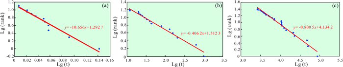
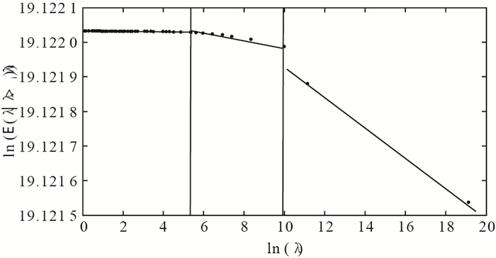
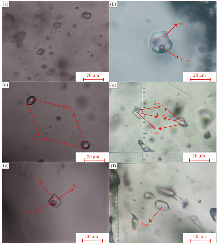
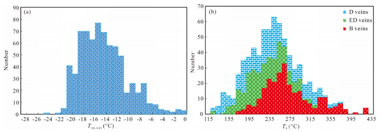
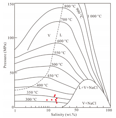
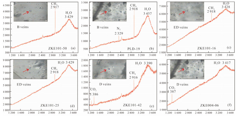
In this paper, the east ore section of the Pulang porphyry copper deposit is selected as the research object. The micro-thermometer and laser Raman spectroscopic technique are utilized to study the parameters of ore-forming fluids such as pressure, temperature, and compositions. In the meantime, the fractal models, including the perimeter-area (P-A) model and number-size (N-S) model, are introduced to quantify the shape of fluid inclusions, and distinguish the stages of ore-forming fluids, respectively. The results show that the types of fluid inclusions are diversified, namely two-phase liquid-rich type, two-phase vapor-rich type, three-phase CO2-rich type, three-phase halite-bearing type and pure liquid type. The fluids of main mineralization stage are characterized by medium-high temperature (170.2-421.4℃), medium-high salinity (9.3 wt.%-33.3 wt.%), and low density (0.73-1.06 g/cm3). With the migration and evolution, the temperature, salinity, and pressure of ore-forming fluids gradually decrease, while the density of fluids increases. The liquid-phase compositions mainly include H2O, and the vapor-phase compositions consist of H2O, CH4, N2, and CO2, indicating the characteristics of reducing fluids and the mixing of atmospheric precipitation. In general, the characteristics of ore-forming fluids in the east ore section are similar to those of the first mining area, suggesting that the ore-forming fluids in the east ore section may not migrate from the first mining area. And the east ore section may be a relatively independent metallogenic system. Moreover, the fractal analysis results demonstrate that the shape of fluid inclusions formed in the same hydrothermal activity features self-similarity. The DAP values of fluid inclusions in B veins, ED veins, and D veins are 1.04, 1.06 and 1.10, respectively, showing a gradually increasing trend from the main stage to the late stage of mineralization. Meanwhile, the shape of fluid inclusions ranging from B veins to D veins becomes increasingly irregular. It also reveals that the homogenization temperature satisfies fractal distribution with four scale-invariant intervals, suggesting that all B veins, ED veins, and D veins have experienced at least four hydrothermal activities. Compared with histogram, the N-S fractal model is able to describe the distribution characteristics of the ore-forming fluids' homogenization temperature more precisely. Therefore, it presents a potential tool for the stage division of ore-forming fluids. This research provides information about the characteristics of ore-forming fluids in the east ore section of the Pulang porphyry copper deposit, which is beneficial for further exploration in this region, and the extension of the application of fractal models in the study of fluid inclusions. However, further testing of fractal models on the fluid inclusion study is warranted to fully determine the universality.
Detection of Geochemical Element Assemblage Anomalies Using a Local Correlation Approach
Xianchuan Yu, Shicheng Wang, Hao Wang, Yuchen Liang, Siying Chen, Kang Wu, Zhaoying Yang, Chongyang Li, Yunzhen Chang, Ying Zhan, Wang Yao, Dan Hu
2021, 32(2): 408-414. doi: 10.1007/s12583-021-1444-9
Abstract:
As direct prospecting data, geochemical data play an important role in modelling prospect potential. Geochemical element assemblage anomalies are usually reflected by the correlation between elements. Correlation coefficients are computed from the values of two elements, which reflect only the correlation at a global level. Thus, the spatial details of the correlation structure are ignored. In fact, an element combination anomaly often exists in geological backgrounds, such as on a fault zone or within a lithological unit. This anomaly may cause some combination of anomalies that are submerged inside the overall area and thus cannot be effectively extracted. To address this problem, we propose a local correlation coefficient based on spatial neighbourhoods to reflect the global distribution of elements. In this method, the sampling area is first divided into a set of uniform grid cells. A moving window with a size of 3×3 is defined with an integer of 3 to represent the sampling unit. The local correlation in each unit is expressed by the Pearson correlation coefficient. The whole area is scanned by the moving window, which produces a correlation coefficient matrix, and the result is portrayed with a thermal diagram. The local correlation approach was tested on two selected geochemical soil survey sites in Xiao Mountain, Henan Province. The results show that the areas of high correlation are mainly distributed in the fault zone or the known mineral spots. Therefore, the local correlation method is effective in extracting geochemical element combination anomalies.
Detection of Multivariate Geochemical Anomalies Using the Bat-Optimized Isolation Forest and Bat-Optimized Elliptic Envelope Models
Yongliang Chen, Shicheng Wang, Qingying Zhao, Guosheng Sun
2021, 32(2): 415-426. doi: 10.1007/s12583-021-1402-6
Abstract:
Isolation forest and elliptic envelope are used to detect geochemical anomalies, and the bat algorithm was adopted to optimize the parameters of the two models. The two bat-optimized models and their default-parameter counterparts were used to detect multivariate geochemical anomalies from the stream sediment survey data of 1:50 000 scale collected from the Helong district, Jilin Province, China. Based on the data modeling results, the receiver operating characteristic (ROC) curve analysis was performed to evaluate the performance of the two bat-optimized models and their default-parameter counterparts. The results show that the bat algorithm can improve the performance of the two models by optimizing their parameters in geochemical anomaly detection. The optimal threshold determined by the Youden index was used to identify geochemical anomalies from the geochemical data points. Compared with the anomalies detected by the elliptic envelope models, the anomalies detected by the isolation forest models have higher spatial relationship with the mineral occurrences discovered in the study area. According to the results of this study and previous work, it can be inferred that the background population of the study area is complex, which is not suitable for the establishment of elliptic envelope model.
Identification of the Ore-Forming Anomaly Component by MSVD Combined with PCA from Element Concentrations in Fracture Zones of the Laochang Ore Field, Gejiu, SW China
Jiangnan Zhao, Shouyu Chen
2021, 32(2): 427-438. doi: 10.1007/s12583-021-1423-1
Abstract:
Fault and fractures are well-developed in the Gejiu tin-polymetallic district, and they are closely related to the formation and distribution of ores. In this paper, the principal component analysis (PCA) and multifractal singular value decomposition (MSVD) methodologies were applied for identification of the ore-forming anomaly components from element concentrations of fault rocks in the Laochang ore field, Gejiu. The results show that: (1) the wall rocks and fault rocks have anomalous concentrations of ore-forming elements, indicating that these elements are mainly derived from fluid/rock interaction in the fracture zones; (2) PCA based on clr-transformed data was used to recognize significant association anomalies of ore-forming elements, which lay a foundation for further extracting ore-forming anomaly components from the element association anomalies related to Sn-Cu mineralization; (3) MSVD could effectively explore local anomaly features and decompose ore-forming element association anomalies associated with buried mineralization in more detail. The ore-forming element anomaly components can delineate ore-finding Sn-Cu polymetallic deposits more exactly than the ore-forming element association anomalies.
Mineral Exploration Using Subtle or Negative Geochemical Anomalies
Renguang Zuo
2021, 32(2): 439-454. doi: 10.1007/s12583-020-1079-2
Abstract:
Mineral resources prediction and assessment is one of the most important tasks in geosciences. Geochemical anomalies, as direct indicators of the presence of mineralization, have played a significant role in the search of mineral deposits in the past several decades. In the near future, it may be possible to recognize subtle geochemical anomalies through the use of processing of geochemical exploration data using advanced approaches such as the spectrum-area multifractal model. In addition, negative geochemical anomalies can be used to locate mineralization. However, compared to positive geochemical anomalies, there has been limited research on negative geochemical anomalies in geochemical prospecting. In this study, two case studies are presented to demonstrate the identification of subtle geochemical anomalies and the significance of negative geochemical anomalies. Meanwhile, the opportunities and challenges in evaluating subtle geochemical anomalies associated with mineralization, and benefits of mapping of negative anomalies are discussed.
Hierarchical MPS-Based Three-Dimensional Geological Structure Reconstruction with Two-Dimensional Image(s)
Weisheng Hou, Hengguang Liu, Tiancheng Zheng, Wenjie Shen, Fan Xiao
2021, 32(2): 455-467. doi: 10.1007/s12583-021-1443-x
Abstract:
Multiple-point statistics (MPS) is a useful approach to reconstruct three-dimensional models in the macroscopic or microscopic field. Extracting spatial features for three-dimensional reconstruction from two-dimensional training images (TIs), and characterizing non-stationary features with directional ductility are two key issues in MPS simulation. This study presents a step-wise MPS-based three-dimensional structures reconstruction algorithm with the sequential process and hierarchical strategy based on two-dimensional images. An extension method is proposed to construct three-dimensional TIs. With a sequential simulation process, an initial guess at the coarsest scale is simulated, in which hierarchical strategy is used according to the characteristics of TIs. To obtain a more refined realization, an expectation-maximization like iterative process with global optimization is implemented. A concrete example of chondrite micro-structure simulation, in which one scanning electron microscopy (SEM) image of the Heyetang m eteorite is used as TI, shows that the presented algorithm can simulate complex non-stationary structures.
IUGS' Initiative on Data-Driven Geoscience Discovery
Qiuming Cheng
2021, 32(2): 468-470. doi: 10.1007/s12583-021-1455-6
Abstract: