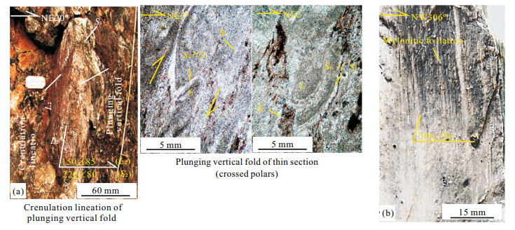
Advanced Search

Indexed by SCI、CA、РЖ、PA、CSA、ZR、etc .

2017 Vol. 28, No. 1

CONTENTS
CONTENTS
2017, 28(1): .
Abstract:
Paleontology
Facies Analysis and Biostratigraphy of the Miocene Sequence, Cairo-Suez District, Egypt
Abdelbaset El-Sorogy, Mohamed Abd-Elmoneim, Ahmed Mowafi, Khaled Al-Kahtany, Hisham Gahlan
2017, 28(1): 1-8. doi: 10.1007/s12583-016-0906-2
Abstract:
Miocene siliciclastic-carbonate deposits are widely exposed in Cairo-Suez District, Egypt. These deposits are underlain and overlain by continental sediments of Oligocene and post Miocene, respectively. Three stratigraphic sections were investigated at Gabals Geneife, Homeira and Gharra. Lithostrtigraphically, the Miocene sequence could be differentiated into two main rock units representing shallow deposits with relatively intermittent deep marine incursions. These are from base to top, Gharra Formation and Genefe Formation. Detailed macrofossils investigations led to the recognition of four macrofossil zones, namely Alectryonella plicatula-Crassostrea frondosa Range Zone, Echinolampas amplus-Scutella ammonis Range Zone, Chlamys(Macrochlamys)sardoa-Chlamys(Argopecten)submalvinae Range Zone, and Chlamys gentoni-Pecten (Oppenheimopecten)benedictus-Pecten(P.)ziziniae Assemblage Zone. Microfacies analysis and identified taxa indicated that the Miocene sequence was deposited in transgressive-regressive cycles ranged from near shore, warm shallow inner to middle shelf marine environments with storm influence during the accumulation of the oyster banks.
Middle Triassic Radiolarians from Cherts/Siliceous Shalesinan Extensional Basin in the Sukhothai Fold Belt, Northern Thailand
Hathaithip Thassanapak, Mongkol Udchachon, Qinglai Feng, Clive Burrett
2017, 28(1): 9-28. doi: 10.1007/s12583-017-0740-x
Abstract:
More than thirty species of radiolarians are described from maroon chert and siliceous shales from the Den Chai and Santisuk sections in the east of the Sukhothai fold belt. The fauna obtained from Den Chai comprises Muelleritortis cochleata cochleata, M. cochleata tumidospina, M. expansa, Triassocampe deweveri, T. coronata, T. scalaris, Annulotriassocampe companilis, A. multisegmantatus, A. sulovensis, Pseudostylosphaera coccostyla coccostyla, P. imperspicua, Canoptum inornatus, C. levis, Corum kraineri, Spongoserrula rarauana, Orbiculiforma karnica and others. The assemblage may be correlated with those reported in the Fang-Chiang Dao and Lumphun areas in the north of Thailand and in the Changning-Menglian belt of western Yunnan, South China and suggests a late Ladinian (Middle Triassic) age. The radiolarian fauna from the Santisuk Section comprises Muelleritortis cochleata cochleata, M.sp., Striatotrissocampe nodosoannulata, Triassocampe. deweveri, T.sp., Pseudogodia? sp., Pseudostylosphaera coccostyla coccostyla, Archaeocenosphera sp., Annulotriassocampe multisegmantis, Pseudostylosphaera sp., and others which indicates a late Ladinian age. Middle Triassic radiolarian chert and siliceous shale from Den Chai and Santisuk are interpreted as having been deposited in an extensional continental margin within the Sukhothai fold belt and not in the Devonian-Permian back-arc basin of the Nan suture. These deep marine sequences were deposited in a subsiding continental margin in the Lampang-Phrae Basin. We consider these sequences to be part of the Hong Hoi Formation (Anisian-Ladinian) of the Lampang Group which, in turn, may be compared to the Choushui Formation and other associated Middle Triassic formations in the Simao Basin of South China.
Geochemistry of Radiolarian Cherts from a Late Devonian Continental Margin Basin, Loei Fold Belt, Indochina Terrane
Hathaithip Thassanapak, Mongkol Udchachon, Clive Burrett, Qinglai Feng
2017, 28(1): 29-50. doi: 10.1007/s12583-017-0738-4
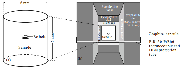
Abstract:
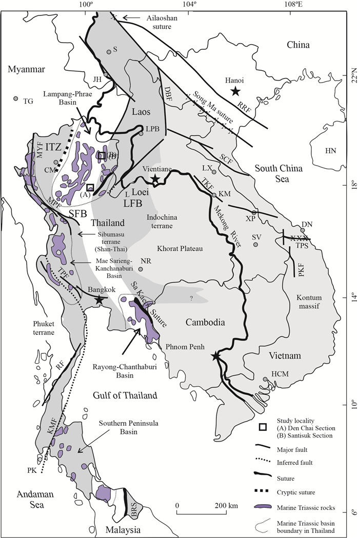
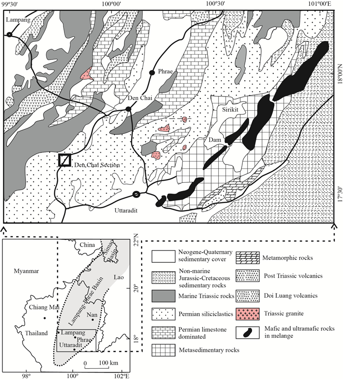
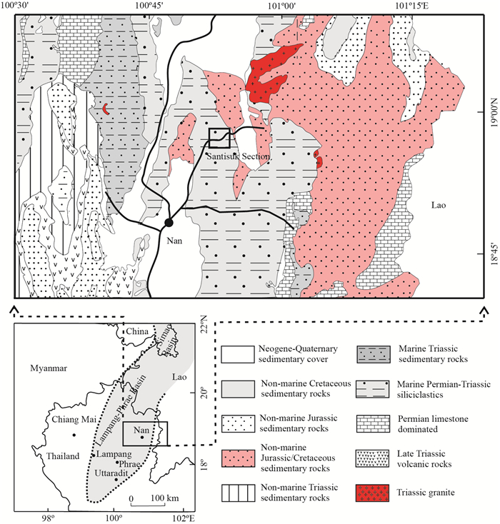
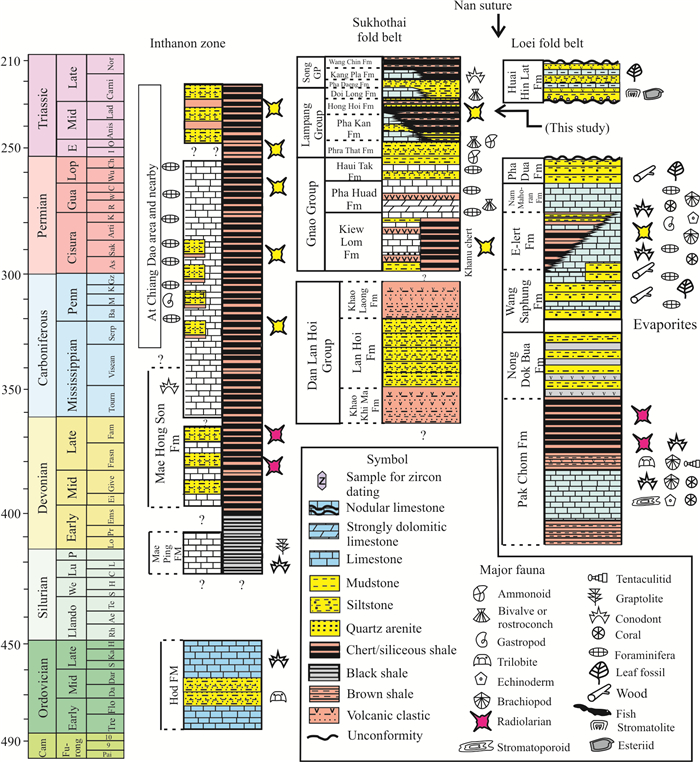
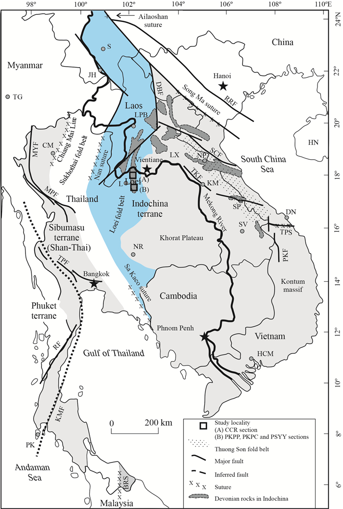
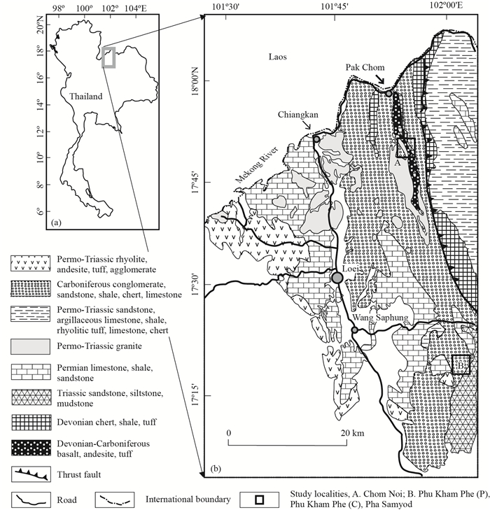
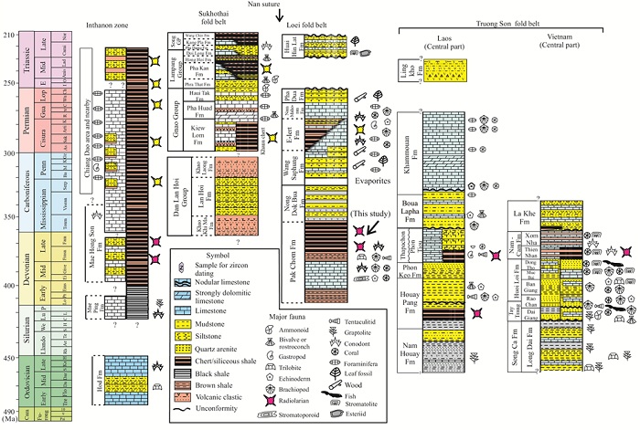
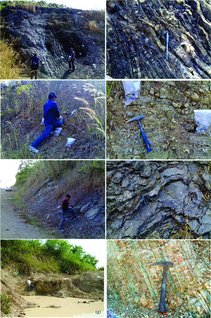
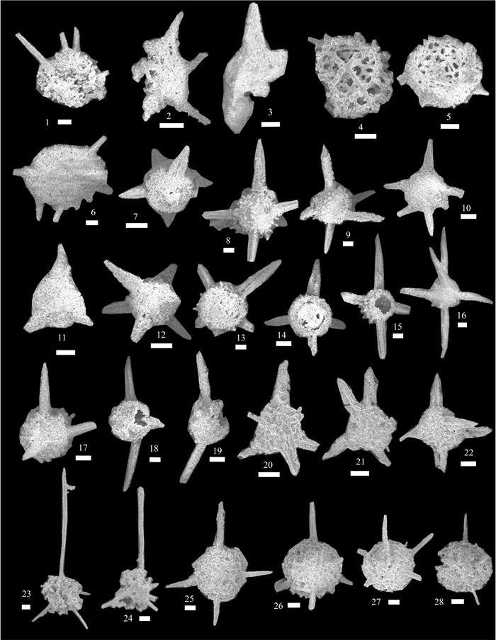
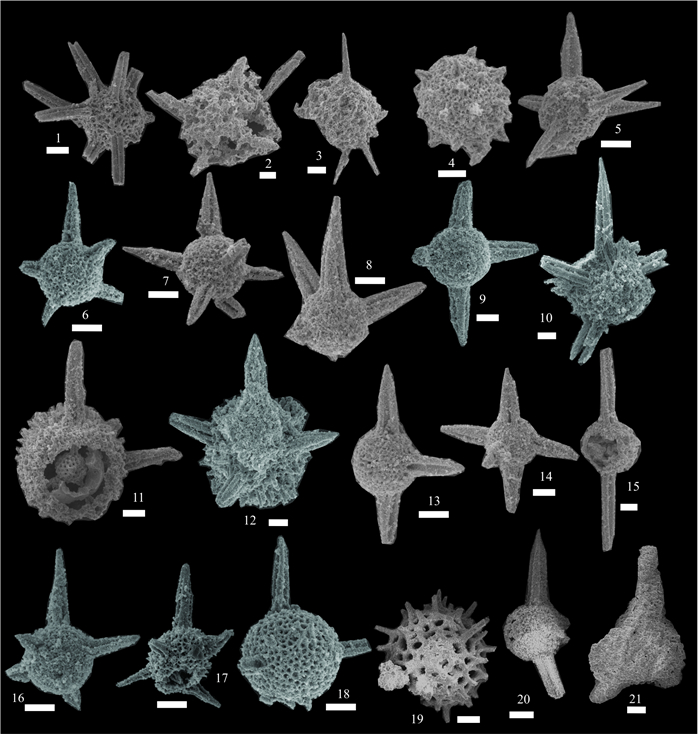
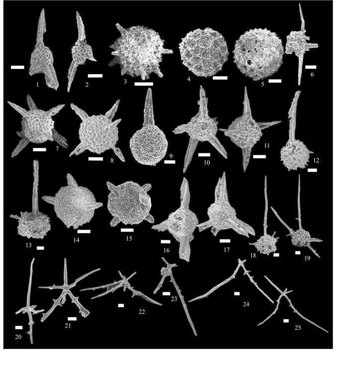
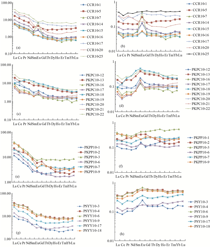
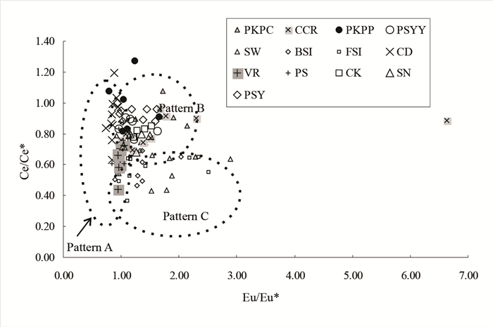
More than 42 species of well-preserved Upper Devonian radiolarians have been obtained from cherts and siliceous shales in four sections (Chom Noi, Phu Kham Phe (P), Phu Kham Phe (C) and Pha Samyod) from the NE Thailand sector of the Loei fold belt, Indochina terrane. They include Ceratoikiscumsp. cf. planistellare Foreman, Helenifore laticlavium Nazarov & Ormiston, Astroentactinia sp. cf. paronae (Hinde), Stigmosphaerostylus herculea(Foreman), S. pusilla (Hinde), S. cf. vulgaris (Won), Trilonche davidi (Hinde), T. echinata (Hinde), T. elegans Hinde, T. hindea (Hinde), T. palimbola (Foreman), T. vetusta Hinde, Polyentactinia polygonia Foreman, Spongentactinella sp. cf. windjanensis Nazarov, Archocyrtiumsp.?, Palaeoscenidium sp., Triaenosphaera sp., and others. Radiolarian faunas from these sections indicate a range from lower Frasnian to Famennian. Analyses of rare earth, trace and major elements suggest that the Upper Devonian chert and siliceous successions from Loei were deposited in a continental margin environment near to a volcanic arc. These successions contain distinctive weak negative Ce anomalies with strong positive Eu anomalies which differ from Upper Devonian cherts reported from northern Thailand, the Truong Son fold belt (Laos) and from South China. Negative Ce anomalies and low to moderate Lan/Cen ratios imply proximity between the Chom Noi and Phu Kham Phe (C), which were deposited in more distal parts of the depositional basin than the Pha Samyod and Phu Kham Phe (P) samples. Most of the Pha Samyod and Phu Kham Phe (P) samples exhibit high continental-derived trace element levels including Cr, Zr, Hf, Rb, Th and in part V, which supports close proximity to terrigenous sources. Paleozoic stratigraphic sequences of the Loei fold belt and geochemical results suggest that the Upper Devonian deep marine sequences in the Loei fold belt were deposited within a rifted, continental-margin basin, possibly a back-arc basin and not in a large oceanic basin as has been previously suggested.
Petrogeochemistry and Mineral Deposit Geochemistry
Permian-Triassic highly-fractionated I-type granites from the southwestern Qaidam basin (NW China): Implications for the evolution of the Paleo-Tethys in the Eastern Kunlun orogenic belt
Yinjuan Ju, Xiaoli Zhang, Shaocong Lai, Jiangfeng Qin
2017, 28(1): 51-62. doi: 10.1007/s12583-017-0745-5
Abstract:
Late Paleozoic to Early Mesozoic granites are widespread in the southern Qaidam Basin, northern margin of the eastern Kunlun orogenic belt. Their petrogenesis can provide us insights into the tectonic evolution and crustal growth process in the Qaidam Basin. This paper reports Permian-Triassic granites from the Kunbei area, southwestern Qaidam Basin. Detailed zircon LA-ICP MS U-Pb dating reveals that the granites from the four drilling cores (q404, q406, q1612-8, q1613-8) have identical ages of 251±3, 256±4, 247±2, and 251±6 Ma, respectively, these ages are identical with the Permian-Triassic granites from the eastern Qaidam Basin. Detailed geochemical analyses indicate that these granites display typical affinities of highly-fractionated I-type granites: (1) they have high SiO2(up to 76.5 wt.%), Na2O+K2O (7.91 wt.% to 9.48 wt.%) contents and high FeOT/MgO values of 4.7 to 9.3, suggesting significant fractional crystallization; (2) their low A/CNK values of 0.54 to 1.03, no normative Al-rich minerals, inconsistent with the per-aluminous S-type granites; (3) their low Ga (14.5 ppm to 20.7 ppm) and 10000×Ga/Al (2.23 to 3.03, most of them < 2.6) values are inconsistent with the A-type granites; (4) the high Rb (191 ppm to 406 ppm) contents and Rb/Sr (2.1 to 13.4) ratios, as well as the significant negative Eu anomalies (0.10 to 0.42) also indicate significant fractional crystallization of feldspars; (5) their low P2O5 contents (0.02 wt.% to 0.10 wt.%) suggest the limited solubility of phosphorus in primitive metaluminous melts. In combination with the geological background, we propose that the Permian-Triassic highly-fractionated I-type granites resulted from partial melting of intra-crustal mafic rocks, and the primitive I-type granitic melts underwent significant fractional crystallization of feldspars. The occurrence of highly-fractionated I-type granites in the southwestern Qaidam Basin suggests a Permian-Triassic active continental margin in the northern margin of the East Kunlun orogenic belt.
Paleontology
Geochemistry of Kestelek Colemanite Deposit, Bursa, Turkey
Şükrü Koç, Özge Kavrazlı, İsmail Koçak
2017, 28(1): 63-77. doi: 10.1007/s12583-015-0616-x
Abstract:
The Kestelek borate deposit has been the subject of geological and mineralogical research over the last decades, but major and trace element geochemistry of this deposit was first investigated in the present study. A total of 22 samples collected from surface exposures and different depths of deposit in boreholes (e.g., lower, middle and upper) comprise the material of this study. Major, trace and REE element analyses of samples were conducted with ICP-MS and ICP-ES methods. The Kestelek borate deposit of Miocene age was formed in playa lakes in an intermountain closed basin which was developed in volcanically and seismically active areas associated with growth faults and grabens affected the whole Anatolia at the beginning of Paleogene. Only colemanite was found as the borate mineral accompanied in lesser amount by calcite, aragonite, smectite, illite, chlorite, corrensite, heulandite and quartz. In colemanite samples, all major elements, except for Ca, show depletion trends with respect to average of earth crust and andesite. For the trace elements, Li, Cs, Sb, As, Sr and Se are characterized by significantly high concentrations. Evaluation of element concentrations and geochemical characteristics reveal that As, Cs, Sb and Li are of detrital origin, Se together with B and Ca are of non-detrital and Sr is indicative of both detrital and non-detrital origin. REE distributions indicate that at least two different depositional regimes prevail in the environment. Corrensite, a clay mineral forming in lake waters, is derived from volcanism. Negative Ce and positive Eu anomalies are indicative of contribution from hydrothermal solutions and fluids.
Experimental Geochemistry
A High Temperature and High Pressure Experimental Study on Re-Bearing Capability of Sulfide
Yingying Liu, Zhilong Huang, Chengming Zhu
2017, 28(1): 78-91. doi: 10.1007/s12583-017-0739-3
Abstract:
High temperature (1 270Ƀ1 550 ¦) and high pressure (1.0 GPa) experimental studies on Re-bearing capabilities of pyrite, galena and sphalerite from typical Pb-Zn ore deposits were performed on a six-anvil apparatus. We observed microstructures of the quenched sulfides using scanning electron microscope (SEM) and analyzed compositions of the run products using both energy disperse spectroscopy (EDS) and electron probe microanalyzer (EPMA). The results show that pyrite melt can dissolve much more metallic Re than galena and sphalerite melts, forming scattered acicular ReS2 in the quenched matrix of pyrrhotite (Fe1-xS). The quenched matrixes of Fe1-xS, PbS and ZnS generally contain less than 1.0 wt.% of Re and their Re-bearing capabilities seem to range as Fe1-xS > PbS > ZnS. However, Re partition coefficients between them are difficult to estimate, because Re distribution is inhomogeneous in the quenched sulfide matrixes.
Simultaneous Measurement of Major, Trace Elements and Pb Isotopes in Silicate Glasses by Laser Ablation Quadrupole and Multi-Collector Inductively Coupled Plasma Mass Spectrometry
Mengning Dai, Zhi'an Bao, Kaiyun Chen, Chunlei Zong, Honglin Yuan
2017, 28(1): 92-102. doi: 10.1007/s12583-017-0742-8
Abstract:
A method was developed for the rapid in situ analysis of major and trace elements and Pb isotopes in silicate glass samples that combines laser ablation quadrupole and multi-collector inductively coupled plasma mass spectrometry (LA-Q-ICP-MS/MC-ICP-MS). Major, trace elements, and Pb isotope ratio compositions were clearly affected by laser conditions. Using a laser spot size of 160 μm, a laser ablation frequency of 15 Hz, an energy density 18 J/cm2, and a 1 : 9 ratio of laser ablation aerosol to the corresponding makeup gas, we obtained accurate major and trace element contents and Pb isotope ratios. Using Ca as the internal standard element, and GSE-1G and NIST 610 as the external standards for calibration, element contents generally matched the preferred values within 15%. Higher relative errors for some elements (e.g., Cr, Ga, Ge) may have been caused by lower than recommended values in some standards. The exponential law correction method for Tl normalization, with optimum adjusted Tl ratio, was utilized to obtain Pb isotopic data with good precision and accuracy. Pb isotopic ratios of the glass reference materials were in good agreement with the reference or published values to within 2 s measurement uncertainties, and the analytical precision was better than 0.17% (e.g., 208Pb/206Pb). The developed method is a simple, reliable, and accurate technique for determining major, trace elements, and Pb isotope compositions of silicate glasses and minerals within a single ablation event.
Hydrogeology and Geo-hazards
Geoelectrical Investigation of Groundwater Potentials of Northern Paiko, Niger State, North Central Nigeria
Usman D. Alhassan, Daniel Nnaemeka Obiora, Francisca Nneka Okeke
2017, 28(1): 103-112. doi: 10.1007/s12583-017-0748-2
Abstract:
Vertical electrical sounding (VES) was carried out in northern part of Paiko, North Central Nigeria, using Abem terrameter model SAS 4000 to determine the subsurface layer parameters (resistivities, depths and thickness) employed in delineating the groundwater potential of the area. A total of six transverses with ten VES stations along each traverse, at intervals of 50 m were investigated. It has a maximum current electrode separation (AB/2) of 100 m. Three to four distinct geoelectric layers were observed, namely, the top layer, the weathered layer, the fractured/fresh layer, and the fresh basement layer. The observed frequencies in curve types include 21% of H, 4.2% of HA, 2.4% of K, 4.2% of A, 1.67% of KH and 3% of HK. Eight VES stations were delineated as ground water potentials of the area, with third and fourth layer resistivities ranging from 191 to 398 Ω·m. Depths range from 13.60 to 36.60 m and thickness varies from 9.23 to 30.51 m. A correlation of the borehole log with the VES lithology is in agreement. Viable boreholes for good portable water should be sited at VES stations J8 and J10 having a fine aquifer at a depth of 36.60 and 17.80 m respectively with thickness of 30.51 and 15.07 m, respectively.
Spatial Variation of Hydraulic Conductivity Categories in a Highly Heterogeneous Aquifer: A Case Study in the North China Plain (NCP)
Rong Ma, Jiansheng Shi, Xianyao Shi
2017, 28(1): 113-123. doi: 10.1007/s12583-016-0636-1
Abstract:
Compared with research on spatial variation of hydraulic conductivity (K), less effort has been made researching different grades of K value in the North China Plain (NCP). In this study, 3D spatial distribution models of different grades of K were established by considering the effects of clay fraction content and uniformity coefficient (Cu). The K value can be divided into five grades: very low, low, permeable, high, and very high groups. The volume percentages of these clusters were 3.06%, 36.01%, 55.70%, 4.82%, and 0.41% for the first aquifer; 0.016%, 9.56%, 88.25%, 2.16%, and 0.014% for the second aquifer; and 0.04%, 17.74%, 84.21%, 0.001%, and 0.01% for the third aquifer. It is concluded that the high and very high K values are fully affected by burial depth and that the very low, low, and permeable K values are mainly controlled by depositional environment and are partially influenced by burial depth. The burial depth became the main influencing factor only within the same depositional environment, causing the overall K to decrease with depth. The variations of very low, low, permeable, high, and very high categories of K values with depth are described in this study. This can provide useful information for non-technical decision makers to achieve sustainable development of deep groundwater resources.
Sorption Properties of Hard Coals with Regard to Gases Present in the Mine Atmosphere
Agnieszka Dudzińska
2017, 28(1): 124-130. doi: 10.1007/s12583-016-0716-2
Abstract:
In this study, the sorption capacities of hard coals with reference to gases present in the mine atmosphere: carbon dioxide, methane, ethane, ethene, propane, propene, carbon monoxide and hydrogen were examined. For laboratory tests, 4 samples of hard coals collected from exploitable coal seams were selected. Among considered gases the mostly sorbed is carbon dioxide, in slightly smaller amounts are sorbed unsaturated hydrocarbons: ethene and propene. Their large sorption results from i.a. interactions of p electrons in the double bond between carbon atoms in the ethene or propene molecules with energetic centers of the coal surface. The amounts of the sorbed saturated hydrocarbons: ethane and propane are small, which is probably related to the adsorption mechanism of their sorption by coals. In the smallest amounts are sorbed hydrogen and carbon monoxide, the values of their sorption being maximum 5% of hard coals sorption capacity in relation to carbon dioxide. Based on the experiments it was found that the largest amounts of gases are sorbed by low-rank, highly porous coals with high oxygen content. The process of sorption of unsaturated hydrocarbons: ethene and propene can lead to a reduction in concentration of those gases in the mine atmosphere and thus may affect correctness of the self-heating phenomenon assessment.
Mathematical Geology and Remote Sensing Geology
A New Mathematical Framework and Spatial Decision Support System for Modeling Cascade Interdependency of Critical Infrastructure during Geo-Disasters
Qiuming Cheng
2017, 28(1): 131-146. doi: 10.1007/s12583-017-0746-4
Abstract:
Critical infrastructures (CI) are designated sectors that if incapacitated or destroyed by natural disasters would have a serious impact on national security and economic and social welfare. Due to the interdependency of critical infrastructures failure of one infrastructure during a natural disaster such as earthquake or flood may cause failure of another and so on through a cascade or escalating effect. Quantification of these types of interdependencies between critical infrastructures is essential for effective response and management of resources for rescue, recovery, and restoration during times of crises. This paper proposes a new mathematical framework based on an asymmetric relation matrix constructed in a bottom-up approach for modeling and analyzing interdependencies of critical infrastructures. Asymmetric dependency matrices can be constructed using the asymmetric incidence coefficient based on node-level relationships defined between nodes for measuring the strength of interdependency between node and node, node and network, and networks and networks. These asymmetric matrices are further analyzed for ranking infrastructures in terms of their relative importance and for identifying nodes and infrastructure networks that play a critical role in chain effects among infrastructures involved in geo-disaster events such as flooding. Examples of interdependency analysis for the identification of vulnerabilities among fifteen national defense-related infrastructure sectors by the Australian government and a simulated example using the newly developed GIS-based network simulator GeoPN are used to validate and demonstrate the implementation and effectiveness of interdependency analysis methods in analyzing infrastructure interdependency during a flooding event.
Tracing Escaping Structure in the Northern Indo-China Peninsula by Openness and Remote Sensing
Jie Zhang, Qinglai Feng, Zhi Zhang
2017, 28(1): 147-160. doi: 10.1007/s12583-017-0743-7
Abstract:
The Openness based on DEM emphasizes the terrain convexity and concavity. It facilitates the interpretation of detailed landforms on the Earth’s surface. Compared with the layer stacking of ETM+ with less three-dimensionality and visualizability and with indefinite details of linear images in the deep cutting or deep covered region, the Openness is used for accurate interpretation of tectonic geomorphic units and linear structures. In this paper, the ETM+ images (741 RGB) and RRIM based on Openness combined with the field geological investigation are used to trace the escaping structure in SE Asia. The east boundary is Ailaoshan shear zone and the west boundary is Uttaradit-Dien Bien Phu fault, which together form the southwards extruding wedge block. The arc boundary surface of the southern Khorat Plateau is jutted to the north. The NW and NE sides of Khorat Plateau are traversed by Uttaradit-Dien Bien Phu fault and Thakhek-Da Nang fault, respectively, resulting in a blocked escaping structure. The SE margins of Truong Son structure belt and Song Ma structure belt are both arcs jutting to SE. These arc structures clamped by faults or related to the fault on one side indicating the material flow direction obviously, are the most specific manifestation of escaping structures. Moreover, these push units are extruded from south to north successively.
Geodynamics
Heat Shielding Effects in the Earth’s Crust
Yixian Xu, Lupei Zhu, Qinyan Wang, Yinhe Luo, Jianghai Xia
2017, 28(1): 161-167. doi: 10.1007/s12583-017-0744-6
Abstract:
Knowledge of heat flow and associated variations of temperature with depth is crucial for understanding how the Earth functions. Here, we demonstrate possible heat shielding effects that result from the occurrence of mafic intrusions/layers (granulitic rocks) within a dominantly granitic middle crust and/or ultramafic intrusions/layers (peridotitic rocks) within a dominantly granulitic lower crust; heat shielding is a familiar phenomenon in heat engineering and thermal metamaterials. Simple one-dimensional calculations suggest that heat shielding due to the intercalation of granitic, granulitic and peridotitic rocks will increase Moho temperatures substantially. This study may lead to a rethinking of numerous proposed lower crustal processes.
Lunar Exploration and Meteorolite Study
Automatic Stitching Method for Chang'E-2 CCD Images of the Moon
Zhi Li, Mengjie Ye, Zhanchuan Cai, Zesheng Tang
2017, 28(1): 168-179. doi: 10.1007/s12583-017-0737-5
Abstract:
The lunar map is a product of primary scientific objectives of lunar exploration. Aiming at the characteristics of the Chang'E-2 CCD data, an automatic stitching method used for 2C level CCD data from Chang'E-2 lunar mission is proposed. Combining with the image registration technique and the characteristics of Chang'E CCD images, the fast method proposed not only can overcome the contradiction of the high spatial resolution of the CCD images and the low positioning accuracy of the location coordinates, but also can speed up the processing and minimize the utilization of human resources to produce lunar mosaic map. Meanwhile, a new lunar map from 70°N to 70°S with spatial resolution of less than 10 m has been completed by the proposed method. Its average relative location accuracy of the adjacent orbits CCD image data is less than 3 pixels.
Hydrocode Simulation of the Impact Melt Layer Distribution underneath Xiuyan Crater, China
Zongyu Yue, Kaichang Di
2017, 28(1): 180-186. doi: 10.1007/s12583-017-0741-9
Abstract:
In this research, we studied the distribution of impact melt layers underneath Xiuyan crater using hydrocode simulation. The target was modeled by granite based on the rock type distribution around the crater and projector by iron, because most small and isolated terrestrial craters are formed by iron projectile. The simulated crater diameter and depth are 1 710 and 320 m, respectively, which are in good agreement with observations of 1 800 and 307 m (except for the post-impact lacustrine sedimentation). The validated model shows that impact melt materials were first formed along the transient crater floor and wall by highshock pressure, and then refilled inward the crater along with collapse of the crater wall. The final style of impact melt materials is interbedded with shock breccia underneath the crater center, which is verified through two layers in the borehole located in the crater center.