Advanced Search

Indexed by SCI、CA、РЖ、PA、CSA、ZR、etc .

2020 Vol. 31, No. 6

CONTENTS
List of Publication for Journal of Earth Science in 2020
2020, 31(6)
Abstract:
ERRATUM I
Erratum to: Definition of the Seismic Field of the Underground Sources in the Ambient Seismic Noise in the Tien Shan Region Using a Three-Component Gradient System
Anatoly Kuzmich Rybin, Elena Anatol'evna Bataleva, SeKseniia Nepeina Nepeina, Pavel Alexandrovich Kaznacheev, Pavel Alexandrovich Matiukov, Pavel Nikolaevich Aleksandrov
2020, 31(6): I-I. doi: 10.1007/s12583-020-1374-y
Abstract:
CONTENTS
2020, 31(6): .
Abstract:
Special Column on Advances in Evaluation and Mitigation of Geohazards Related to Unstable Slopes
A Predictive, Two-Parameter Model for the Movement of Reservoir Landslides
Robert E. Criss, Wenmin Yao, Changdong Li, Huiming Tang
2020, 31(6): 1051-1057. doi: 10.1007/s12583-020-1331-9
Abstract:
Monitoring data show that many landslides in the Three Gorges region,China,undergo step-like displacements in response to the managed,quasi-sinusoidal annual variations in reservoir level. This behavior is consistent with motion initiating when the reservoir water level falls below a critical level that is intrinsic to each landslide,with the subsequent displacement rate of the landslide being proportional to the water depth below that critical level. Most motion terminates when the water level rises back above the critical level,so the annual step size is the time integral of the instantaneous displacement rate. These responses are incorporated into a differential equation that is easily calibrated with monitoring data,allowing prediction of landslide movement from actual or anticipated reservoir level changes. Model successes include (1) initiation and termination of the annual sliding steps at the critical reservoir level,producing a series of steps; (2) prediction of variable step size,year to year; and (3) approximate prediction of the shape and size of each annual step. Annual rainfall correlates poorly with step size,probably because its effect on groundwater levels is dwarfed by the 30 m annual variations in the level of the Three Gorges Reservoir. Viscous landslide behavior is suggested.
Reservoir Regulation for Control of an Ancient Landslide Reactivated by Water Level Fluctuations in Heishui River, China
Jian Guo, Mo Xu, Qiang Zhang, Xianxuan Xiao, Shishu Zhang, Shaoming He
2020, 31(6): 1058-1067. doi: 10.1007/s12583-020-1341-7
Abstract:
Due to the complex geological processes of Qinghai-Tibet Plateau,numerous deposits,especially the large-scale ancient landslide deposits,are characteristic features of the valleys incised in southwestern China. Intense water level fluctuations since 2011 in Maoergai Reservoir,China,registered the reactivation of Xierguazi ancient landslide,and presented a significant risk to neighboring facilities. Based on detailed field survey and drilling exploration,the landslide was divided into Zone A and Zone B,and other characterizations of landslide were studied as well. To precisely measure the extent of landslide displacement during filling and drawdown stage,surface displacement monitoring system was deployed on the landslide. The monitoring analyses data reveal that reservoir fluctuation is the dominant factor influencing landslide displacement,especially during drawdown stage. Moreover,a future sliding is anticipated in Zone A,while a creep had already existed in Zone B. A reservoir regulation was then established using the lead-lag correlation between reservoir fluctuation and landslide displacement and landslide stability analysis. In the end,the follow-up deformation monitoring demonstrates that the reservoir regulation controlled the landslide effectively. Landslide control by reservoir regulation in Maoergai can serve as a case study for other settlements involved in similar construction activities.
An Optimized Random Forest Model and Its Generalization Ability in Landslide Susceptibility Mapping:Application in Two Areas of Three Gorges Reservoir, China
Deliang Sun, Jiahui Xu, Haijia Wen, Yue Wang
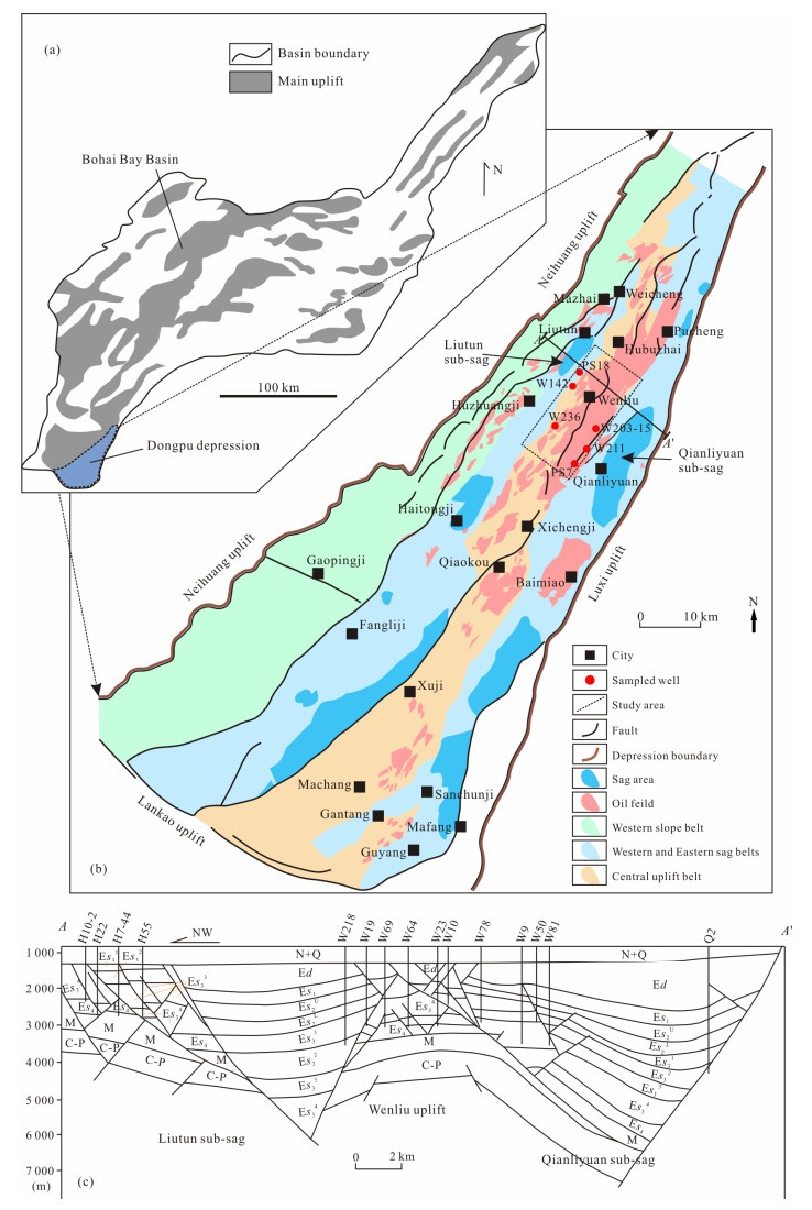
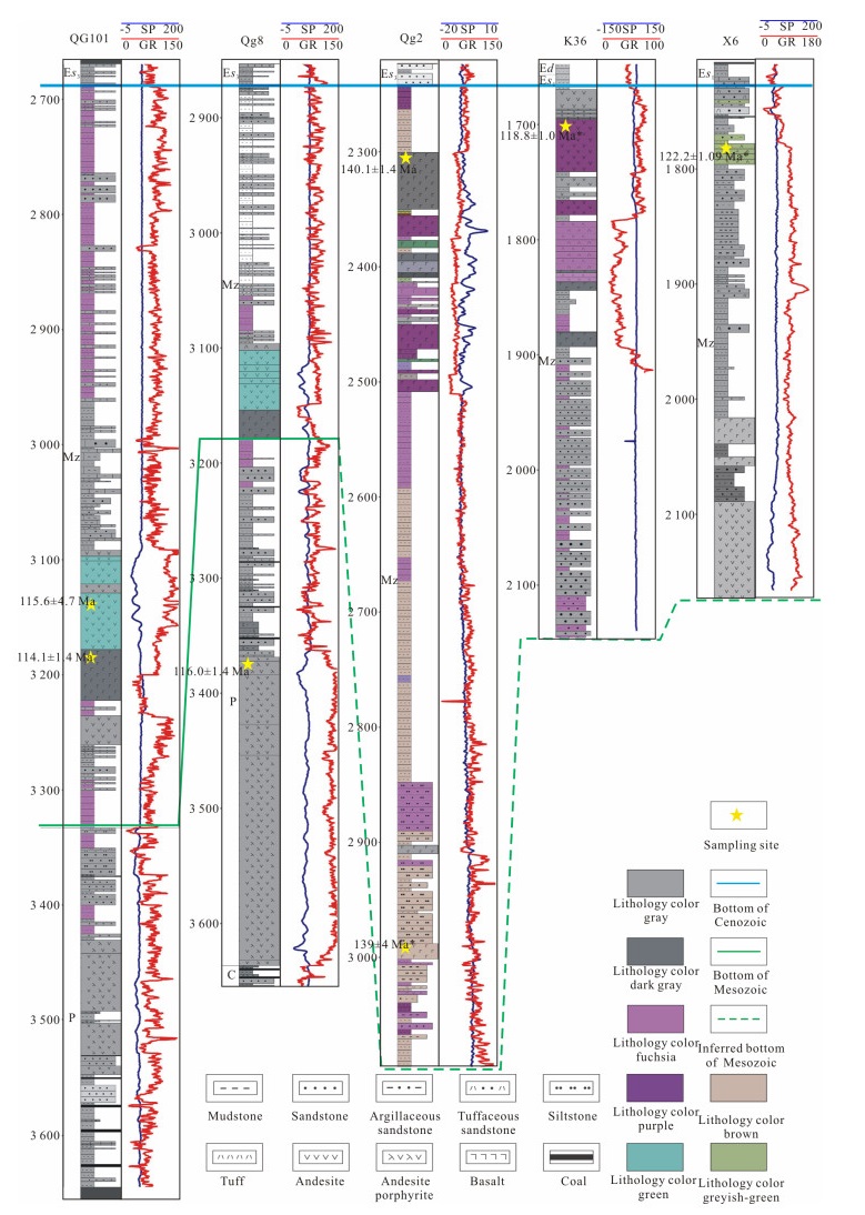
2020, 31(6): 1068-1086. doi: 10.1007/s12583-020-1072-9
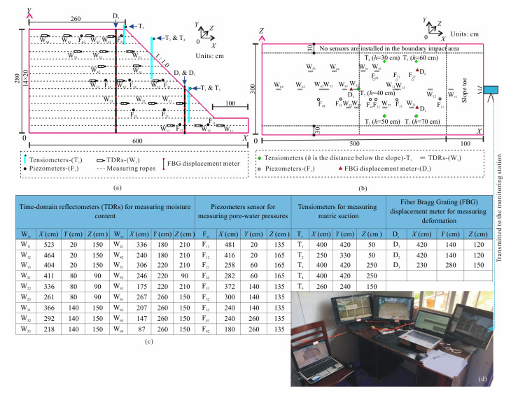
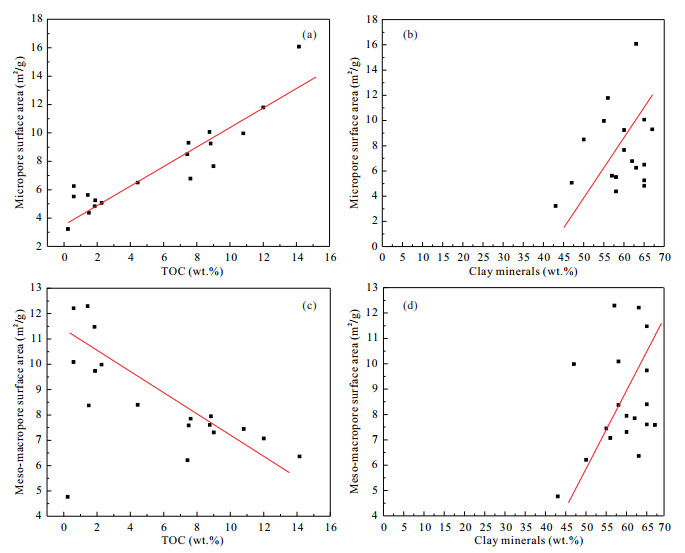
Abstract:
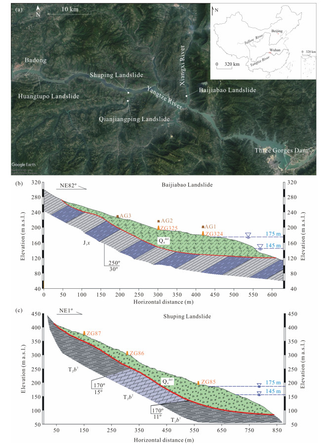
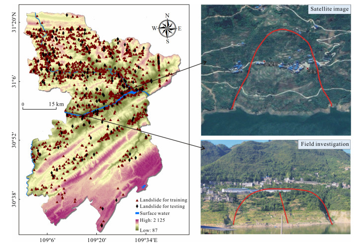
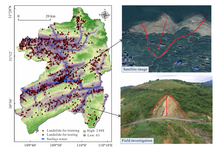
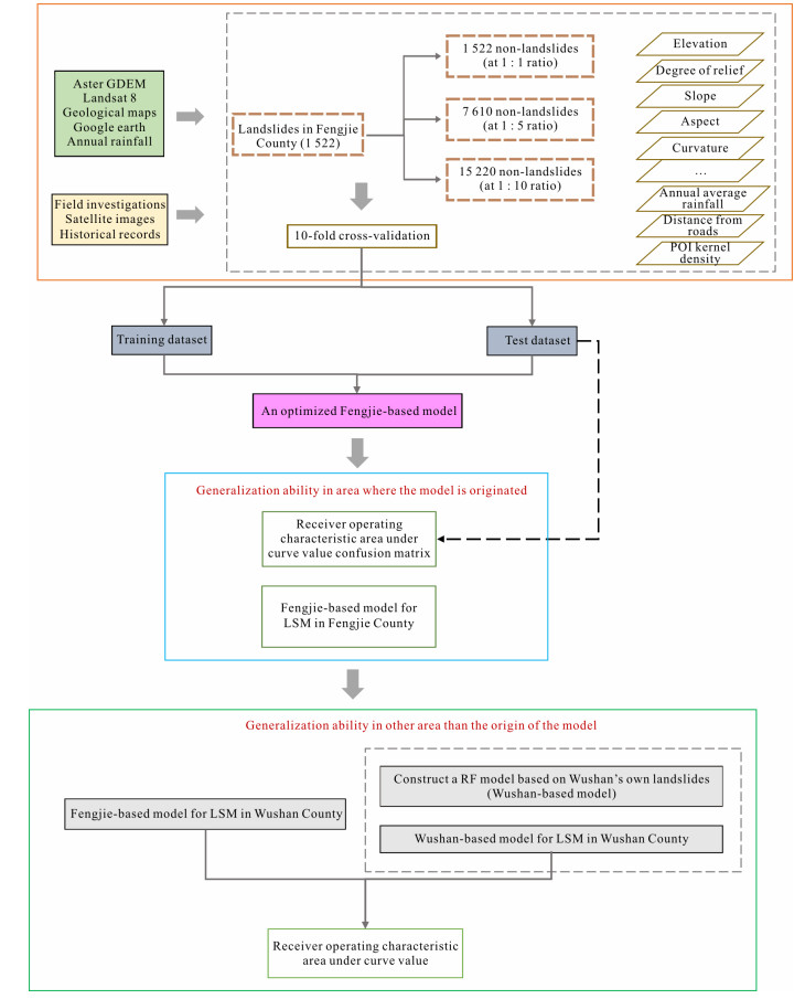
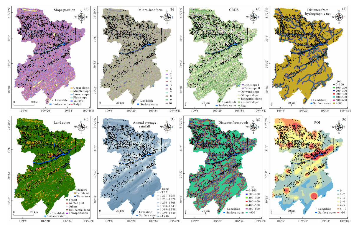
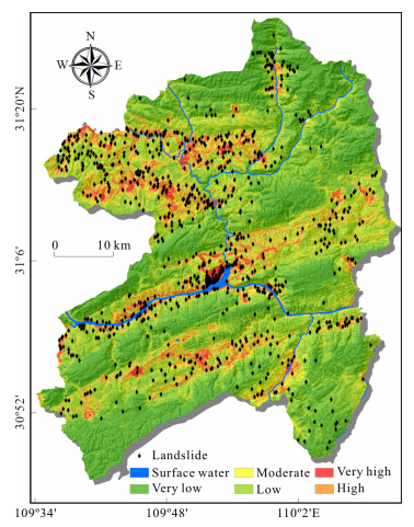
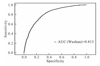
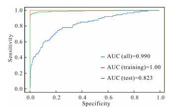
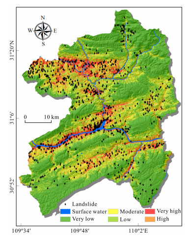
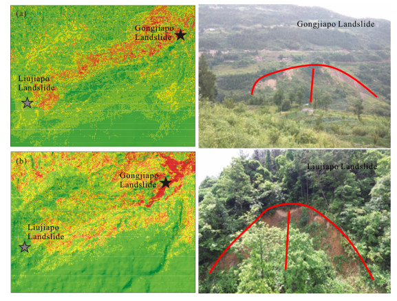
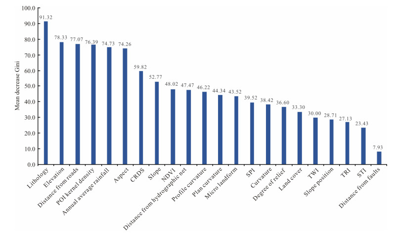
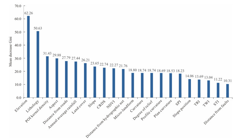
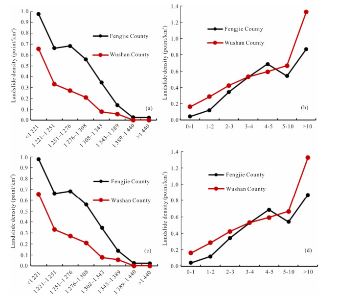
Numerous researches have been published on the application of landslide susceptibility assessment models; however,they were only applied in the same areas as the models were originated,the effect of applying the models to other areas than the origin of the models has not been explored. This study is purposed to develop an optimized random forest (RF) model with best ratios of positive-to-negative cells and 10-fold cross-validation for landslide susceptibility mapping (LSM),and then explore its generalization ability not only in the area where the model is originated but also in area other than the origin of the model. Two typical counties (Fengjie County and Wushan County) in the Three Gorges Reservoir area,China,which have the same terrain and geological conditions,were selected as an example. To begin with,landslide inventory was prepared based on field investigations,satellite images,and historical records,and 1 522 landslides were then identified in Fengjie County. 22 landslide-conditioning factors under the influence of topography,geology,environmental conditions,and human activities were prepared. Then,combined with 10-fold cross-validation,three typical ratios of positive-to-negative cells,i.e.,1:1,1:5,and 1:10,were adopted for comparative analyses. An optimized RF model (Fengjie-based model) with the best ratios of positive-to-negative cells and 10-fold cross-validation was constructed. Finally,the Fengjie-based model was applied to Fengjie County and Wushan County,and the confusion matrix and area under the receiver operating characteristic (ROC) curve value (AUC) were used to estimate the accuracy. The Fengjie-based model delivered high stability and predictive capability in Fengjie County,indicating a great generalization ability of the model to the area where the model is originated. The LSM in Wushan County generated by the Fengjie-based model had a reasonable reference value,indicating the Fengjie-based model had a great generalization ability in area other than the origin of the model. The Fengjie-based model in this study could be applied in other similar areas/countries with the same terrain and geological conditions,and a LSM may be generated without collecting landslide information for modeling,so as to reduce workload and improve efficiency in practice.
Geometry and Maximum Width of a Stable Slope Considering the Arching Effect
Kun Fang, Huiming Tang, Xuexue Su, Wentao Shang, Shenglong Jia
2020, 31(6): 1087-1096. doi: 10.1007/s12583-020-1052-0
Abstract:
The stability of an arching slope in deformable materials above strong rocks strongly depends on the shape and width of the span. Equations for a free surface problem that incorporate these two parameters were derived using a simplified two-dimensional arching slope model,and were validated using physical model tests under 1g and centrifugal conditions. The results are used to estimate the maximum excavation width for a weak claystone slope in a lignite mine,for which we calculate a safety factor of 1.31.
Large-Scale Test Model of the Progressive Deformation and Failure of Cracked Soil Slopes
Zhi Zhou, Jiaming Zhang, Fulong Ning, Yi Luo, Lily Chong, Kuangbiao Sun
2020, 31(6): 1097-1108. doi: 10.1007/s12583-020-1342-6
Abstract:
A large-scale test bed (LWH=6 m×3 m×2.8 m) instrumented with various sensors is used to examine the effects of rainfall infiltration and evaporation on the deformation and failure of cracked soil slopes,taking the Anhui area along the Yangtze River as a field example. The results indicate that (1) during rainfall,the soil around the shallow shrinkage fissures attains transient saturation,and the attendant decrease of matric suction is the primary cause of the shallow slope failure; (2) slope deformation continues during post-rainfall evaporation; (3) if a period of evaporation is followed by heavy rainfall,soil creep is concentrated near the deepest cracks,and two zones of steep gradients in pore pressure form at the crest and toe of the slope. Finally,a saturated zone forms near each crack base and gradually enlarges,eventually forming a continuous saturated layer that induces the slope instability or failure.
Model Test of Deformation Evolution and Multi Factor Prediction of Anchorage Slope Stability under Rainfall Condition
Tingyao Wu, Jianhong Jia, Nan Jiang, Chuanbo Zhou, Xuedong Luo, Yuqing Xia
2020, 31(6): 1109-1120. doi: 10.1007/s12583-020-1343-5
Abstract:
The stability of the anchorage slope on the Baiyang Yangtze River Highway Bridge in Yichang,China,was investigated under different rainfall conditions using model test,numerical simulation,and factor analysis. The results of the study are as follows:(1) with the increase of rainfall intensity,the change of earth pressure can be divided into three stages. However,when the rainfall intensity was larger than a certain value,the change of earth pressure of cut slope became two stages; with the increase of rainfall intensity,pore water pressure increased with the increase of rainfall time,while at a certain stage after the rainfall,the pore water pressure in the cut slope did not decrease immediately,but increased for a period of time. (2) When the rainfall stopped,the stability coefficient of the anchorage slope continued to decrease,then slowly increased,and finally tended to be gentle. Meanwhile,when the rainstorm reached a certain intensity,the main factor that restricted the rainfall infiltration rate became the geotechnical permeability coefficient of the cut slope,which was no longer the rainfall intensity. (3) Factor analysis shows that the rainfall intensity and rainfall duration were the most important factors for anchorage slope stability,while earth pressure,pore water pressure and slope displacement were much less significant.
Slope Stability Analysis Based on Group Decision Theory and Fuzzy Comprehensive Evaluation
Peng Xia, Xinli Hu, Shuangshuang Wu, Chunye Ying, Chang Liu
2020, 31(6): 1121-1132. doi: 10.1007/s12583-020-1101-8
Abstract:
A slope stability evaluation method is proposed combining group decision theory, the analytic hierarchy process and fuzzy comprehensive evaluation. The index weight assignment of each evaluation element is determined by group decision theory and the analytic hierarchy process, and the membership degree of each indicator is determined based on fuzzy set theory. According to the weights and memberships, the membership degrees of the criterion layer are obtained by fuzzy operations to evaluate the slope stability. The results show that (1) the evaluation method comprehensively combines the effects of multiple factors on the slope stability, and the evaluation results are accurate; (2) the evaluation method can fully leverage the experience of the expert group and effectively avoid evaluation errors caused by the subjective bias of a single expert; (3) based on a group decision theory entropy model, this evaluation method can quantitatively evaluate the reliability of expert decisions and effectively improve the efficiency of expert group discussion; and (4) the evaluation method can transform the originally fuzzy and subjective slope stability evaluation into a quantitative evaluation.
Discharge-Stage Relationship on Urban Streams Evaluated at USGS Gauging Stations, St. Louis, Missouri
Robert E. Criss, David L. Nelson
2020, 31(6): 1133-1141. doi: 10.1007/s12583-020-1089-0
Abstract:
Extensive USGS data tables and detailed, 1 m2 LiDAR surveys are used to determine the optimal power n that relates discharge (Q) to stage (h*) above channel bottom (ho) at 39 gauging stations on small streams in the St. Louis, Missouri area, all of which have catchments of 0.6 to 220 km2. Four different methodologies are employed to determine both n and ho:(1) optimizing linearity in a plot of Q1/n vs. local stage (hL) using USGS field measurements at each site; (2) optimizing linearity in a plot of Q1/n vs. hL using USGS rating tables at each site; (3) a mathematical inverse method applied to the same USGS rating tables; (4) use of LiDAR data on channel geometry to determine the power dependences of channel area A and hydraulic radius H on h*, combined with the Manning and rational equations to predict n. Of these methods, only methods 2 and 3 compare favorably, and these values compare poorly with Method 1 based on field data, and with method 4 based on theoretical and empirical relationships. Because Method 4 is predictive, it provides a useful alternative to methods 1-3 that are based on USGS field measurements, which are heavily weighted toward low discharges. We conclude that the apparent values of n in the USGS rating tables are systematically too low for small streams.
Do Supercontinent-Superplume Cycles Control the Growth and Evolution of Continental Crust?
Xuan-Ce Wang, Simon A. Wilde, Zheng-Xiang Li, Shaojie Li, Linlin Li
2020, 31(6): 1142-1169. doi: 10.1007/s12583-020-1077-4
Abstract:
The evolution of continental crust can be directly linked to the first-order supercontinent-superplume cycles. We demonstrate that:(1) a mantle-like oxygen isotopic signature is not a diagnostic feature for distinguishing crustal addition from the reworking of pre-existing continental crust; (2) juvenile continental crust shows a wide range of whole-rock Hf isotopic compositions throughout Earth's history; and (3) detrital zircon Hf model ages cannot reliably determine the growth of continental crust. Thus, the wide use of zircon Hf model ages, based on zircon grains with mantle-like oxygen isotopes, is inappropriate for estimating the timing of continental crustal generation. Based on an analysis of global Hf and O isotope and zircon age databases, we argue that the actual U-Pb crystallization ages of juvenile zircon grains provide the best opportunity to unravel crustal growth through time and to test its relationship with supercontinent-superplume cycles. Furthermore, when the Hf isotopes of these juvenile grains plot within the field of juvenile continental crust, they correlate well with times of global mantle depletion as recorded by Os and He isotopes, plume activity as recorded by LIP events, and periods of crustal growth and the breakup of supercontinents. In contrast, zircon grains crystallized from magmas that were produced by partial melting of pre-existing continental crust show U-Pb age peaks that correspond mainly to times of supercontinent assembly and crustal reworking. Detailed analysis shows the key role played by recycling of mafic crustal components in the generation of juvenile continental crust.
Effects of Water on the Rheology of Dominant Minerals and Rocks in the Continental Lower Crust:A Review
Zhonghang Wang, Feng Shi, Junfeng Zhang
2020, 31(6): 1170-1182. doi: 10.1007/s12583-020-1307-9
Abstract:
As an important part of the continental lithosphere, the continental lower crust can influence and control many important geodynamic processes, which are of great significance to the evolution of the lithosphere. Extensive plastic deformation is common in continental lower crust. There have been many studies focusing on the rheology of the continental lower crust in the past few decades. This paper provides a review on the effects of water on the rheology of dominant minerals (clinopyroxene, plagioclase and garnet) and rocks in the continental lower crust. The water contents in continental lower crustal minerals and rocks are in general rich and very heterogenous from sample to sample and region to region. Water can significantly reduce the strength of clinopyroxene, plagioclase, garnet and lower crustal rocks. Water can also have a profound influence on fabric development and slip systems in lower crustal minerals. Quantitative experimental investigations and extensive natural studies of water effect on rheology are necessary to refine the classic lithosphere strength profile models and to address the existing controversy on strength of the continental lower crust.
An Investigation of Dislocation in Olivine Phenocrysts from the Hawaiian Basalts
Zhuo-Yue Li, Da-Peng Wen, Yong-Feng Wang, Xiangwen Liu
2020, 31(6): 1183-1189. doi: 10.1007/s12583-020-1338-2
Abstract:
Intracrystalline distortions (like undulose extinction, dislocations, and subgrain boundaries) in olivine from naturally-deformed peridotites are generally taken as signs of dislocation creep. However, similar features in olivine phenocrysts that have been found in basaltic magmas are still not well understood. In particular, whether subgrain boundaries in olivine phenocrysts arise from plastic deformation or grain growth is still debated (in the latter case, they are essentially grain boundaries but not subgrain boundaries. Therefore, we used hereinafter subgrain-boundary-like structures instead of subgrain boundaries to name this kind of intracrystalline distortion). Here we carried out a detailed study on dislocations and subgrain-boundary-like (SG-like) structures in olivine phenocrysts from two Hawaiian basaltic lavas by means of petrographic microscopy, scanning electron microscopy, and transmission electron microscopy (TEM). Abundant and complex dislocation substructures (free dislocations, dislocation walls, and dislocation tangles) were observed in the decorated olivine grains, similar to those in olivine from peridotite xenoliths entrained by the Hawaiian basalts. The measured average dislocation density is (2.9±1.3)×1011 m-2, and is three to five orders of magnitude higher than that in laboratory-synthesized, undeformed olivine. TEM observations on samples cut across the SG-like structures by FIB (focused ion beam) demonstrated that this kind of structures is made of an array of dislocations. These observations clearly indicate that these structures are real subgrain boundaries rather than grain boundaries. These facts suggest that the observed high dislocation densities and subgrain boundaries cannot result from crystal crystallization/growth, but can be formed by plastic deformation. These deformation features do not prove that the olivine phenocrysts (and implicitly mantle xenoliths) were deformed after their capture by the basaltic magmas, but can be ascribed to a former deformation event in a dunitic cumulate, which was formed by magmatic fractionation, then plastically deformed, and finally disaggregated and captured by the basaltic magma that brought them to the surface.
Crystal Structure, Thermal Expansivity and High-Temperature Vibrational Spectra on Natural Hydrous Rutile
Sha Wang, Jinhua Zhang, Joseph R Smyth, Junfeng Zhang, Dan Liu, Xi Zhu, Xiang Wang, Yu Ye
2020, 31(6): 1190-1199. doi: 10.1007/s12583-020-1351-5
Abstract:
A natural rutle sample was measured by in situ high-temperature X-ray diffraction (XRD) patterns, as well as Raman and Fourier transform infrared (FTIR). Crystal structure is refined on the sample with 1.4 mol.% Fe and 510±120 ppmw. H2O. The unit-cell and TiO6 octahedral volumes are expanded by 0.7%-0.8% for Fe3+ incorporation, as compared with the reported Ti-pure samples. The volumetric thermal expansion coefficient (α, K-1) could be approximated as a linear function of T (K):4.95(3)×10-9×T+21.54(5)×10-6, with the averaged value α0=30.48(5)×10-6 K-1, in the temperature range of 300-1 500 K. The internal Ti-O stretching (A1g and B2g) and O-Ti-O bending (Eg) modes show 'red shift', whereas the multi-phonon process exhibits 'blue shift' at elevated temperature. The rotational mode (B1g) for TiO6 octahedra is nearly insensitive to temperature variations. The OH-stretching bands at 3 279 and 3 297 cm-1 are measured by high-temperature spectroscopy experiments. Both the IR-active and Raman-active OH-stretching modes shift to lower frequencies at higher temperature, with the signal intensities decreasing. And after quenching, we expect about 43% dehydration around 873 K, and 85% dehydration at 1 273 K for this hydrous sample.
Origin and Tectonic Implications of Post-Orogenic Lamprophyres in the Sulu Belt of China
Songjie Wang, Lu Wang, Yue Ding, Zhuocheng Wang
2020, 31(6): 1200-1215. doi: 10.1007/s12583-020-1070-y
Abstract:
Lamprophyre dykes that crosscut different types of ultrahigh pressure (UHP) metamorphic rocks are widely distributed in the Triassic Sulu UHP orogenic belt. Although abundant studies have been performed on these dykes, their origin and petrogenesis remain topics of controversy. This study presents the results of a detailed field-based study of petrology, whole-rock geochemistry and zircon U-Pb and Lu-Hf isotopes on lamprophyre dykes exposed in the central Sulu UHP zone, aiming at shedding lights on their petrogenesis and providing clues on the geological evolution of eastern continental China during the Cretaceous. The lamprophyres are typically porphyritic, with phenocrysts dominantly composed of amphibole and clinopyroxene set in a lamprophyric matrix. The dykes have moderate SiO2 (47.70 wt.%-60.44 wt.%), variably high MgO (2.58 wt.%-8.28 wt.%) and Fe2O3T (4.88 wt.%-9.26 wt.%) contents with high Mg# of 49-66. Geochemically, they have enriched light rare earth element (REE) and flat heavy REE patterns ((La/Gd)N=5.14-10.56; (Dy/Yb)N=1.43-1.54) with negligible Eu anomalies (Eu/Eu*=0.83-1.10), and they show enrichment in large ion lithophile elements (e.g., Ba and K) but depletion in high-field strength elements (e.g., Nb, Ti and P). In-situ zircon U-Pb geochronology reveals that the lamprophyres have concordant ages of 120-115 Ma, demonstrating that the dykes emplaced in the Early Cretaceous. These zircons have εHf(t) values ranging from -26.0 to -11.0. Inherited zircons that occur in the dykes are dated to be Neoproterozoic, in line with the protolith ages of their host (i.e., the UHP rocks). An integration of these data allows us to propose that the lamprophyres were generated during the Cretaceous, by melting of subcontinental lithospheric mantle-derived metasomatite with enriched chemical compositions underneath the North China Craton. The metasomatite was formed mainly by peridotite-fluid/melt reactions, with the fluids/melts mainly liberated from subducted Yangtze continental crust during the Triassic. Regional extension, lithospheric thinning and mantle upwelling caused by rollback of the subducted paleo-Pacific plate is considered to account for the generation of the lamprophyres as well as the extensive arc-like magmatic rocks in eastern continental China during the Early Cretaceous.
Geochronology and Geochemistry of the 890 Ma I-Type Granites in the Southwestern Yangtze Block: Petrogenesis and Crustal Evolution
Jibiao Zhang, Xiaozhong Ding, Yanxue Liu, Heng Zhang, Chenglong Shi, Yu Zou
2020, 31(6): 1216-1228. doi: 10.1007/s12583-020-1339-1
Abstract:
The tectonic evolution of the southwestern Yangtze Block during the Early Neoproterozoic period is still controversial because of the limited quantities of 1 000-860 Ma magmatic rocks. In this study, our new LA-ICP-MS zircon U-Pb dating results demonstrate that the Yanbian granodiorites in the southwest Yangtze Block were emplaced at 894.6±7.4 Ma, representing the product of an 894 Ma magmatism. The Yanbian granodiorites are metaluminous to weak peraluminous with A/CNK values of 0.8-1.1, resembling I-type granitoids. They are characterized by right-inclined REE patterns with moderate to insignificant negative Eu anomalies (δEu=0.6-0.9). Their primitive mantle-normalized trace element patterns are characterized by depletion of Nb, Ta and Ti and weakly enrichment of Th. Considering the positive whole-rock εNd(t) (+5.8 to +6.8), we propose that these granodiorites originated from the partial melting of juvenile mafic lower crust. The Yanbian I-type granitoids have low Y and Nb contents similar to volcanic arc igneous rocks in the Y-Nb plot for tectonic discrimination. In conclusion, Early Neoproterozoic Yanbian granodiorites have generated in a compression setting in an active continental margin. Together with previous studies from the southwestern Yangtze Block, we suggest that the 894 Ma subduction-related Yanbian granodiorites represent the early stage of subduction at the southwestern margin of the Yangtze Block.
Microstructure Characterization of a Biogenic Shale Gas Formation—Insights from the Antrim Shale, Michigan Basin
Kouqi Liu, Natalia Zakharova, Thomas Gentzis, Adedoyin Adeyilola, Humberto Carvajal-Ortiz, Hallie Fowler
2020, 31(6): 1229-1240. doi: 10.1007/s12583-020-1344-4
Abstract:
Biogenic gas shales, predominantly microbial in origin, form an important class of organic-rich shale reservoirs with a significant economic potential. Yet large gaps remain in the understanding of their gas generation, storage, and transport mechanisms, as previous studies have been largely focused on mature thermogenic shale reservoirs. In this study, the pore structure of 18 Antrim Shale samples was characterized using gas adsorption (CO2 and N2). The results show that most of the Antrim Shale samples are rich in organic matter content (0.58 wt.% to 14.15 wt.%), with highest values found in the Lachine and Norwood members. Samples from the Paxton Member, characterized by lower organic content, have smaller micropore surface area and micropore volume but larger meso-macro pore surface area and volume. The deconvolution results of the pore size distribution from the N2 adsorption indicate that all of the tested Antrim Shale samples have similar pore groups. Organic matter in the Antrim Shale hosts micro pores instead of meso-macro pores, while clay minerals host both micro and meso-macro pores. Mineral-related pores play a primary role in the total porosity. The biogenic Antrim Shale, therefore, has different pore structures from other well-studied thermogenic gas shales worldwide.
Microscopic and Fractal Characterization of OrganicMatter within Lacustrine Shale Reservoirs in the FirstMember of Cretaceous Qingshankou Formation, Songliao Basin, Northeast China
Bo Liu, Meng Yan, Xianda Sun, Yunfeng Bai, Longhui Bai, Xiaofei Fu
2020, 31(6): 1241-1250. doi: 10.1007/s12583-020-1345-3
Abstract:
Understanding the occurrences of different fractions of organic matter in shale reservoirs is very important for the evaluation of shale oil. Lacustrine organic-rich shale samples from the first member of the Cretaceous Qingshankou Formation in the Songliao Basin were analyzed with confocal laser scanning microscopy (CLSM) and fluorescence spectral analysis. The results show that the occurrences of different organic components are related to the fabric of samples and vary with depth. The bulk content of light components is significantly higher than heavy components and exhibits a positive relationship with quartz and feldspar contents. Both light and heavy components are distributed parallel with the lamination in microscopic view in laminated samples, and randomly in massive samples. The maximum radius of light components in most of the samples is larger than 20 μm, while it is smaller for heavy components, indicating the micro fractionation from clay/organic lamina to quartz/feldspar lamina. The depth of enrichment of light components corresponds to the oil maturity of organic matter. Both the distribution of light and heavy components fits the same fractal model, with fractal dimensions ranging between 2.2 and 2.5. The CLSM results confirm that it can be a reliable tool for the "sweet spot" exploration.
Mixing Characteristics of Oil Inclusions with Different Thermal Maturities in the Wenliu Uplift, Dongpu Depression, Bohai Bay Basin, North China
Xiuyan Liu, Honghan Chen, Xuewei Xiao, Hongan Zhang, Tianwu Xu
2020, 31(6): 1251-1258. doi: 10.1007/s12583-020-1356-0
Abstract:
Multiple types of oil inclusions with different fluorescence colors have been detected in the northern Dongpu depression. Recent evidences show that these inclusions may have been trapped simultaneously or during a very short period. Therefore, whether these oils were mixed before trapping is unknown. In this study, we analyzed the petrography and fluorescence spectral characteristics of oil inclusions in the Wenliu uplift in the northern Dongpu depression, and assessed the data with the oil mixing ratio curve obtained in the previous experiment. The results show that there are three types of oil inclusions (type Ⅰ, type Ⅱ and type Ⅲ) with yellow, green and blue fluorescence colors, corresponding to low-mature, medium-mature and high-mature oil, respectively. The "pure" oil inclusions, do exist in type Ⅱ and type Ⅲ group of oil inclusions, showing the medium-mature oil was generated from the source rock rather than being formed by the mixture of high-mature and low-mature end oils. Most of the oil inclusions are mixtures of high-mature and medium-mature end oils from the sub-sags to the Wenliu uplift, the mixing degree increases to close to 50%. The oil between the Qianliyuan sub-sag and the Wenliu uplift was mainly mixed by medium mature oils, whereas the oil between the Liutun sub-sag and the Wenliu uplift was mainly mixed by high mature oil.
An Integrated Mass Balance Approach for Assessing Hydrocarbon Resources in a Liquid-Rich Shale Resource Play:An Example from Upper Devonian Duvernay Formation, Western Canada Sedimentary Basin
Zhuoheng Chen, Chunqing Jiang
2020, 31(6): 1259-1272. doi: 10.1007/s12583-020-1088-1
Abstract:
Petroleum resource assessment using reservoir volumetric approach relies on porosity and oil/gas saturation characterization by laboratory tests. In liquid-rich resource plays, the pore fluids are subject to phase changes and mass loss when a drilled core is brought to the surface due to volume expansion and evaporation. Further, these two closely related volumetric parameters are usually estimated separately with gas saturation inferred by compositional complementary law, resulting in a distorted gas to oil ratio under the circumstances of liquid hydrocarbon loss from sample. When applied to liquid-rich shale resource play, this can lead to overall under-estimation of resource volume, distorted gas and oil ratio (GOR), and understated resource heterogeneity in the shale reservoir. This article proposes an integrated mass balance approach for resource calculation in liquid-rich shale plays. The proposed method integrates bulk rock geochemical data with production and reservoir parameters to overcome the problems associated with laboratory characterization of the volumetric parameters by restoring the gaseous and light hydrocarbon loss due to volume expansion and evaporation in the sample. The method is applied to a Duvernay production well (14-16-62-21W5) in the Western Canada Sedimentary Basin (WCSB) to demonstrate its use in resource evaluation for a liquid-rich play. The results show that (a) by considering the phase behavior of reservoir fluids, the proposed method can be used to infer the quantity of the lost gaseous and light hydrocarbons; (b) by taking into account the lost gaseous and light hydrocarbons, the method generates an unbiased and representative resource potential; and (c) using the corrected oil and gas mass for the analyzed samples, the method produces a GOR estimate close to compositional characteristics of the produced hydrocarbons from initial production in 14-16-62-21W5 well.
Characteristics of the Cretaceous Magmatism in Huanghua Depression and Their Relationships with Hydrocarbon Enrichment
Fengming Jin, Jian Huang, Xiugang Pu, Changqian Ma, Lixin Fu, Chongbiao Leng, Da Lou, Mutian Qin
2020, 31(6): 1273-1292. doi: 10.1007/s12583-020-1308-8
Abstract:
The Huanghua depression located in the hinterland of the Bohai Bay Basin in eastern China is a typical area for the research of multistage magmatic activities with hydrocarbon enrichment, many high-yield wells related to igneous rocks were discovered within the Cretaceous strata in recent years. However, the spatial and temporal distribution of Cretaceous igneous rocks remains unclear, and the relationships among magmatic sequence, lithology, and hydrocarbon enrichment have been poorly studied. In order to solve these problems, core observation, logging analysis, major element analysis, zircon U-Pb chronology, oil-bearing grade statistics and reservoir spaces analysis were used to subdivide the magmatism cycles and to investigate the characteristics of igneous reservoirs. Our results show that the Mesozoic magmatism in Huanghua depression started in 140.1±1.4 Ma and could be divided into two stages including the Early Cretaceous stage and Late Cretaceous stage. The Early Cretaceous magmatism principally developed basic-intermediate rocks in the north zone, and could be subdivided into 3 cycles with their forming ages of 140, 125-119, and 118-111 Ma, respectively. By contrast, the late stage mainly developed intermediate-acid rocks centralized in the south zone and formed at 75-70 Ma. The GR and SP curves are good indicators for the contrast of different lithologies, lithofacies and for magmatic sequences division. Intensive magmatism may have an advantage to form reservoirs, since basalt in cycle Ⅲ in the Early Cretaceous and dacite porphyrite in the Late Cretaceous have great exploration potential. Lithology and tectonic fractures have an important influence on the formation of reservoir spaces and hydrocarbon enrichment. The characteristics of Cretaceous magmatism and igneous reservoirs in Huanghua depression and adjacent areas are summarized, providing important information for igneous reservoirs research and oil-gas exploration in the Cretaceous in related areas.