Advanced Search

Indexed by SCI、CA、РЖ、PA、CSA、ZR、etc .

2020 Vol. 31, No. 5

CONTENTS
CONTENTS
2020, 31(5): .
Abstract:
Petrology and Ore Deposits
Water-Flux Melting of Amphibolite in Paleozoic Leucogranite from the North Qinling, Central China: Implication for Post Collisional Setting
Jiangbo Wang, Tong Li, Yan Zhang, Weihong Li
2020, 31(5): 867-874. doi: 10.1007/s12583-020-1335-5
Abstract:
Paleozoic granites can provide important insights of crustal differentiation and collision process of the North Qinling terrane. The Dafanggou leucogranites that intruded in the Qinling Complex is a Paleozoic granite with zircon U-Pb age of 404±6.4 Ma (MSWD=0.13,n=9). The leucogranites display moderate SiO2 (68.4 wt.% to 71.7 wt.%) content and high Na2O/K2O (1.07 to 2.74) and Sr/Y (42 to 65) ratios,and low A/CNK (1.04 to 1.08) and Rb/Sr (0.09 to 0.16) ratios. Combined with negative εNd(t) (-10.4) and εHf(t) (-9.35 to -0.25) values and ancient TDM2 ages (1.2 to 1.7 Ga),suggesting the leucogranite are derived from ancient amphibolitic crust in the Qinling Group. In addition,the absence of coeval mafic igneous rocks or mafic enclaves occurred in the Dafanggou pluton and the low TZrn (~700℃) of leucogranites preclude that the leucogranites derived from high temperature dehydration melting of amphibolite. Thus,we propose that the occurrence of the Dafanggou leucogranite indicates that water-flux melting of middle-lower crust in post-collision setting may be a potential model for the genesis of granites in collisional orogenic belt.
Hisingerite in Trachydacite from Tarim: Implications for Voluminous Felsic Rocks in Transitional Large Igneous Province
Mingde Lang, Zhiguo Cheng, Zhaochong Zhang, Fangyue Wang, Qian Mao, M. Santosh
2020, 31(5): 875-883. doi: 10.1007/s12583-020-1330-x
Abstract:
Unlike the typical large igneous provinces (LIPs) that are dominated by mafic-ultramafic rocks,the Tarim large igneous province (TLIP) is characterized by a high proportion of felsic rocks,based on which the TLIP is classified as a transitional LIP. In this study,we focus on the trachydacite from the TLIP in which we report the characteristics of hisingerite employing a variety of techniques such as EMPA,LA-ICPMS,CCD single crystal diffraction,and bulk-rock oxygen isotopes. The hisingerite in this rock is associated with plagioclase,amphibole,apatite and ilmenite. These minerals occur as aggregates of fine curled fibers in micron-scale and display heavy rare earth elements (HREE) enriched signature with significant negative Eu anomalies. In the primitive mantle-normalized trace element spider diagrams,they show pronounced Th and U spikes and Nb,Zr,Hf troughs. Petrological observation and mineralogical study reveal a closely genetic relationship between hisingerite and amphibole,indicating that the hisingerite might have been derived from the breakdown of amphibole during the magma ascent. The formation of hisingerite requires excess water from the surrounding melts,suggesting a hydrous parental magma. The hisingerite and amphibole assign a hydrous crustal source for the rock,and extensive crustal melting accounts for the voluminous felsic rocks in the TLIP.
Genesis of Manganese Deposits in the Ali Khanzai Block of the Zhob Ophiolite, Pakistan: Inferences from Geochemistry and Mineralogy
Khan Muhammad Ayoub, Kakar Muhammad Ishaq, Thomas Ulrich, Liaqat Ali, Andrew C. Kerr, Khalid Mahmood, Siddiqui Rehanul Haq
2020, 31(5): 884-895. doi: 10.1007/s12583-020-1337-3
Abstract:
The Zhob ophiolite comprises the Naweoba,Omzha and Ali Khanzai blocks,which are surrounded by the sediments of the Alozai Group and Loralai Formation. The Ali Khanzai Block contains metamorphic,ultramafic,gabbroic,volcanic and volcaniclastic rocks with associated chert. The Zhob manganese deposits found in the Ali Khanzai Block,occur in banded,lenticular and massive forms within red to brown coloured metachert. Braunite and pyrolusite are the main constituent manganese-bearing minerals with minor hausmannite,hematite and barite while quartz is the major gangue mineral with some carbonate minerals. Geochemical evidence from the major oxides indicates that the manganese mineralization and associated metachert at Zhob were formed by hydrothermal activity with little contribution from contemporaneous volcanic materials and this is confirmed by high Fe/Mn and low Co/Zn ratios and trace element patterns. These deposits formed along with seafloor spreading centres and were later obducted as part of Ali Khanzai Block of Zhob ophiolite.
Structural Geology
Detrital Zircon Fission-Track Thermochronology of the Present-Day River Drainage System in the Mt. Kailas Area, Western Tibet: Implications for Multiple Cooling Stages of the Gangdese Magmatic Arc
Tianyi Shen, Guocan Wang
2020, 31(5): 896-904. doi: 10.1007/s12583-020-1285-y
Abstract:
It is still controversial how the high elevation of the Tibetan Plateau established after the Indian-Asian collision during the Cenozoic. The timing of Gangdese magmatic arc exhumation and uplift history would provide useful message for this disputation. We present six zircon fission-track (ZFT) data from modern river sand in the western Tibet,around the Mt. Kailas,to decipher the long-term exhumation histories of the Gangdese magmatic arc. The data suggests that all the Gangdese magmatic arc rocks experienced rapid cooling during the Eocene (~46-35 Ma) and Oligocene (~31-26 Ma). The movement along the north-south trending extensional fault and dextral strike-slip Karakoram fault induced the adjacent rocks exhumed at the Middle Miocene (~15-16 Ma) and Late Miocene (~10-11 Ma),respectively. According to the minimum and central AFT ages for each sample,the fastest exhumation rate is about 0.4 km/Ma,with average long-term exhumation rates on the order of~0.3 km/Ma since the Oligocene. This result supports the outward growth model for plateau forming,indicating the southern margin of the Gangdese magmatic arc attained high elevation after the Oligocene.
Post-Orogenic Tectonic Evolution of the Jiangnan-Xuefeng Orogenic Belt: Insights from Multiple Geochronometric Dating of the Mufushan Massif, South China
Chuanbo Shen, Di Hu, Kyoungwon Min, Chaoqun Yang, Xiaowei Zeng, Hongyang Fu, Xiang Ge
2020, 31(5): 905-918. doi: 10.1007/s12583-020-1346-2
Abstract:
The Mufushan massif,as continental intra-plate magmatites located in the Jiangnan-Xuefeng orogenic belt of the South China. The Mufushan massif constitutes the largest Mesozoic intrusive complex,intruded the Mesoproterozoic Lengjiaxi Formation. Multiple geochronometric dating was used to reconstruct their evolution from emplacement to exhumation. The Mufushan granitoids were emplaced at ~150 Ma (U-Pb zircon) as post-orogenic magmatites contributing to Triassic crustal thickening. Onset of regional extension at ~128 Ma (40Ar/39Ar white mica and biotite) manifests a tectonic regime switch. Intense exhumation prior to ~55 Ma was followed by slow denudation and peneplanation for the next 37 Ma (~55-18 Ma). Accelerated cooling since ~18 Ma may have been caused by a far-field effect of the collision between India-Asia Plate or the Pacific-Plate subduction. Through a multi-geochronometric approach,this study provides a new comprehensive model for the cause of the intra-plate magmatism formation in the South China,and also established a reliable geochronological framework of the post-orogenic tectonic evolutions of the Jiangnan-Xuefeng orogenic belt.
Petroleum, Natural Gas Geology
Comparison of the Petroleum Geology in the Deep-Water Basins between the Passive Margin of Morocco and Its Conjugate Margin of Canada
Chengpeng Song, Shu Jiang, Zhixin Wen, Zhaomin Wang
2020, 31(5): 919-929. doi: 10.1007/s12583-020-1340-8
Abstract:
This paper systematically investigates and compares the petroleum geology elements and oil and gas exploration potential in the deep-water basins along the conjugate passive margins between Morocco in NW Africa and Nova Scotia in Canada. Both the deep-water basins along the passive margin in Morocco and its conjugate passive margin deep-water basin in Nova Scotia have undergone similar multiple stages of tectonic evolution. These conjugate basins both have Jurassic and Cretaceous source rocks; Triassic sandstone,Jurassic-Cretaceous carbonate and sandstone,and Miocene-Pliocene sandstone reservoirs; multiple sets of mudstones and regional Triassic salt as caprocks. These characteristics indicate good hydrocarbon accumulation conditions and exploration prospects. The comparison also reveals that the key exploration targets in the deep-water basins of Morocco should be Tertiary turbidite sandstone reservoirs and Jurassic-Cretaceous sandstone and carbonate reservoirs. Compared with the Scotian Basin,the Morocco deep-water basins may have Paleozoic play potential sourced from the mature Silurian hot shale source rock that extends from the onshore NW African Plate. The prospective exploration targets in the deep-water Scotian Basin should be focused on the Jurassic and Cretaceous deep-water turbidite sandstone reservoirs formed by widely-developed large river systems.
Diagenetic and Reservoir Quality Variation of Miocene Sandstone Reservoir Analogues from Three Basins of Southern California, USA
Sunday E. Okunuwadje, David MacDonald, Stephen Bowden
2020, 31(5): 930-949. doi: 10.1007/s12583-020-1289-7
Abstract:
The Miocene sandstone deposits in the Southern California region are important hydrocarbon reservoirs. However, their development has been very challenging due to the wide variability in their reservoir quality. These sandstones have been studied from three sedimentary basins by petrographic thin section, scanning electron microscope, and X-ray diffraction to evaluate and compare the influence of diagenesis on their reservoir quality in these basins. Four petrofacies, namely P1 (sand injectite or dyke), P2 (sub-marine fan), P3 (turbidite and marine-influenced alluvial fans) and P4 (continental sandstones) have been identified. P1 and P2 characterise the sandstones in the San Joaquin forearc basin and are affected by kaolinite and extensive early calcite diagenesis. P3 and P4 delineate the sandstones in the Cajon Valley and Salton Trough strike-slip basins and are dominated by smectite, mixed illite-smectite, early calcite and late calcite diagenesis. Early calcite cement in P3 and P4 is in lower proportion than in P1 and P2. Although the dissolution of these sandstones by acidic fluids did not have a pattern, it, however, has the most considerable influence on P2 creating moldic pores which are expected to increase pore connectivity. The relatively abundant dissolution pores in P2, together with the absence of late authigenic calcite and illite clay in comparison to the other petrofacies studied are likely to make this sandstone facies the best reservoir targets in the Southern California region. These rocks are analogous to producing reservoirs in the region. However, because, petroleum accumulation in these reservoirs are compartmentalized by early calcite cement, maximum recovery using acidified fluids is recommended to dissolve the calcite-filled pores in order to increase connectivity of their pore network and enhance flow potential.
Seismogeology
Campus Vibration in Nanwangshan Campus, China University of Geosciences at Wuhan Monitored by Short-Period Seismometers
Lihui Wu, Dun Wang, Ziguang Lei, Jing Fu, Shuai Min, Xianbing Xu, Sarina Bao
2020, 31(5): 950-956. doi: 10.1007/s12583-020-1332-8
Abstract:
Continuous seismic observations can record seismic waveforms, and ambient noise, for the purposes of earthquake researches and other applications. Here we deploy three digital seismometers (EPS-2) in and around the Nanwangshan Campus of the China University of Geosciences (Wuhan). This network was running from April 9 to May 9 of 2018. During this period, the seismometers recorded the May 4, 2018 M6.9 Hawaii earthquake. From the recorded waveforms, we could observe clearly the P and S arrivals, and the corresponding particle motions. Analysis of continuous observations of ambient noise shows obvious fluctuation of vibration intensity inside of the campus. The campus is quietest from 0 to 5 am. From 5 am on, the vibration intensity increases, and reaches the peak of entire day at 12 am. The amplitude then decreases to a very low level at 19:30 to 20:00 pm, and reaches another strong noisy time at 21:00 to 21:30 pm. After 21:30 pm, the intensity goes down slowly. We also observed seismic signals that were generated by the interaction of speed-control hump cars and ground. By taking the envelope and smooth operations, we observe different characteristics for different car speeds, which suggests that seismic monitoring approaches can be used for speed measurement of cars. This kind of small seismic network running in a real time fashion, would greatly help understanding of the sources of ambient noise at high frequency bands in interested areas. Analysis of a long-term observed dataset, and real time illustration will help to strengthen campus security and high-precision laboratory deployments, and also contribute to research atmosphere in earthquake science.
Nanoparticles Study on the Indosinian Xiaomei Shear Zone in the Hainan Island, China: Implication to Developmental Stage and Formation Mechanism of Nanoparticles in a Fault Zone
Yang Zhou, Baoyun Shen, Yi Yan, Hailing Liu, Yan Yan
2020, 31(5): 957-967. doi: 10.1007/s12583-020-1286-x
Abstract:
Nanoparticles are widely observed in the natural shear zone and experimental slip faults, which can lubricate the fault and significantly reduce the friction coefficient during seismic slip. But it is still not clear how the nanoparticles develop during the process of sliding. Clarifying the development stage of nanoparticles in a fault zone is critical to understanding the formation mechanisms of nanoparticles and the mechanism of fault weakening from a nanoperspective. In this study, four types of nanoparticles were found in the Indosinian Xiaomei shear zone, including spherical nanoparticles, rod-like nanograins and their aggregations. Ultramicroscopic analyses indicate that polished patches are highly smooth and composed of tightly packed spherical nanoparticles and well orientated rod-like nanograins during slip at high velocities. Meanwhile, the dome nanoparticles were formed by the calcite thermal decomposition due to frictional heat during high-speed sliding. The polygonal grooves are possibly related to high temperature (>900¦) grain boundary sliding deformation mechanisms. However, the porous and rough surfaces are accompanied by a series of holes and parallel "scratches" during a subsequent low-velocity stage. To ascertain the chemical composition of these nanoparticles, the energy dispersive spectrometer (EDS) test were conducted. The results suggest that materials rich in Fe, MgO and wollastonite are likely to form the rod-like nanograins, while materials rich in SiO2 are likely to form the spherical nanoparticles.
Late Quaternary Tectonic Activity and Slip Rates of Active Faults in the Western Hexi Corridor, NW China
Xingwang Liu, Daoyang Yuan, Qi Su, Bo Zhang
2020, 31(5): 968-977. doi: 10.1007/s12583-020-1287-9
Abstract:
The Yinwashan and Xinminpu faults are located in the Jiuxi Basin in the western end of the Hexi Corridor. The determination of their activity and slip rates is of great significance for understanding the eastward extension of the Altyn Tagh fault. Based on geological and geomorphologic field survey, trench excavation, optically stimulated luminescence dating, we define the fault geometry and kinematic properties of the two faults. Based on fault scarps measurement using differential GPS and 10Be surface exposure dating, we determined vertical slip rate of 0.09±0.01 mm/yr for the Yinwashan fault and 0.1±0.02 mm/yr for the Xinminpu fault. Using the dips observed in trenches and natural sections, we estimated horizontal shortening rates of 0.05±0.03 and 0.23±0.06 mm/yr, respectively. No significant strike slip motion is observed on these two faults, and we infer that this region was dominated by horizontal shortening in the Late Quaternary. Although the shortening rate is quite low on each individual fault, together with other faults in this area, these two faults have an essential role in transferring slip from the eastern end of the Altyn Tagh fault and in accommodating the northeastward growth of Tibetan Plateau.
Responses of Stream Geomorphic Indices to Piedmont Fault Activity in the Daqingshan Area of China
Junyi Wang, Zhongtai He
2020, 31(5): 978-987. doi: 10.1007/s12583-020-1321-y
Abstract:
A recent correlation of stream geomorphic indices to fault activity has revealed that stream geomorphologies in bedrock mountain areas are good records of local fault movements. The Daqingshan piedmont fault is one of the main active faults in the fault system on the northern margin of the Hetao Basin and has produced frequent large-scale earthquakes since the Late Pleistocene. In the present study,following the segmentation regime of previous studies,we divide the fault zone into five segments,namely,the Baotou,Tuyouqi West,Tuzuoqi West,Bikeqi,and Hohhot segments,and we discuss the relationship between the drainage basin geomorphology and the piedmont fault activity in the Daqingshan area using 30 m spatial resolution Shuttle Radar Topography Mission (SRTM) digital elevation model (DEM) data. We use a range of geomorphic indices to examine the drainage basins in the Daqingshan area,including the channel steepness index (ksn),slope,hypsometric integral (HI),relief degree of land surface (RDLS),and stream lengthgradient index (SL),extracted with ArcGIS and MATLAB,and we also consider local lithologic and climate aspects. Furthermore,we compare the geomorphic indices with the slip rates of individual segments of the Daqingshan piedmont fault and paleoseismic data. The results show that the geomorphic indices of drainage basins in the Daqingshan area are primarily affected by the piedmont fault activity in the Daqingshan area. The geomorphic indices also demonstrate that piedmont fault activity has been the most intense in the middle segment of this fault system since the Late Quaternary and decreases towards the two sides.
Definition of the Seismic Field of the Underground Sources in the Ambient Seismic Noise in the Tien Shan Region Using a Three-Component Gradient System
Anatoly Kuzmich Rybin, Elena Anatol'evna Bataleva, SeKseniia Nepeina Nepeina, Pavel Alexandrovich Kaznacheev, Pavel Alexandrovich Matiukov, Pavel Nikolaevich Aleksandrov
2020, 31(5): 988-992. doi: 10.1007/s12583-020-1327-5
Abstract:
This paper considers a new approach to solving the problem of quantitative estimation of the microseism energy for underground sources that is based on the synthesis of noise interferometry and the passive seismic method of the gradient system. The selection of a seismic field of the underground sources is considered in an experiment conducted in the Tien Shan region. The peculiarities of approach include the separation of vertical microseisms in the ambient seismic noise field structure according to the data of the seismic gradient system and a passive noise interferometry diagram, where microseisms from the underground sources are used as the seismic signal source. It is shown that the use of noise interferometry and passive seismic gradient system allows using the synchronous microseism recordings in a small number of points for passive medium sensing, and leads to the restoration of unknown energy parameters of the seismic field of underground sources.
Hydrogeology and Environmental Geology
Contribution of Hydrogeochemical and Isotopic Tools to the Management of Upper and Middle Cheliff Aquifers
Madene Elaid, Meddi Hind, Boufekane Abdelmadjid, Meddi Mohamed
2020, 31(5): 993-1006. doi: 10.1007/s12583-020-1293-y
Abstract:
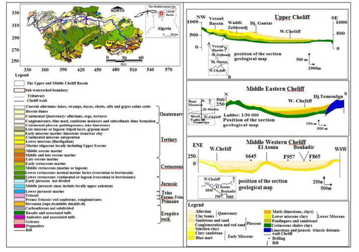
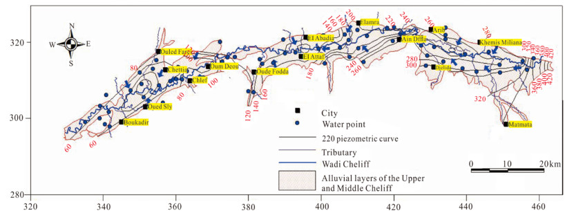
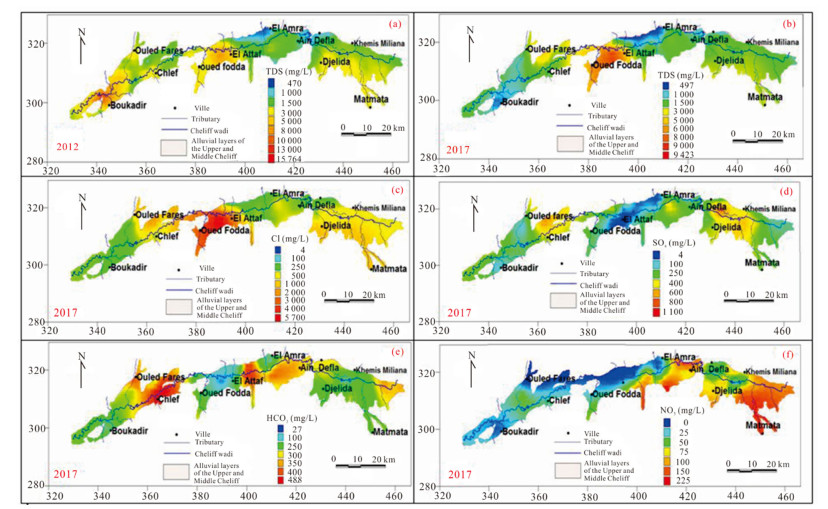
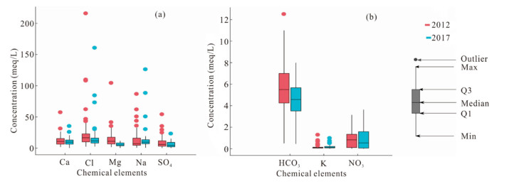
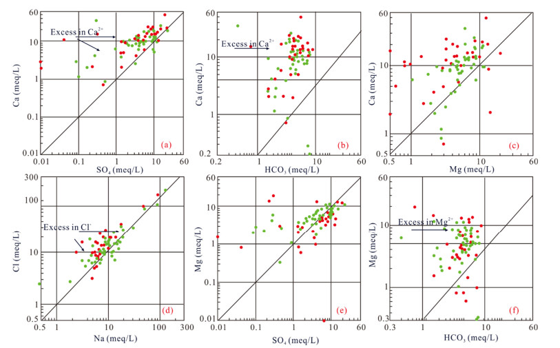
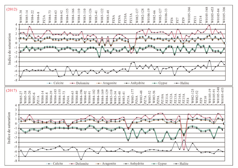
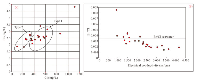
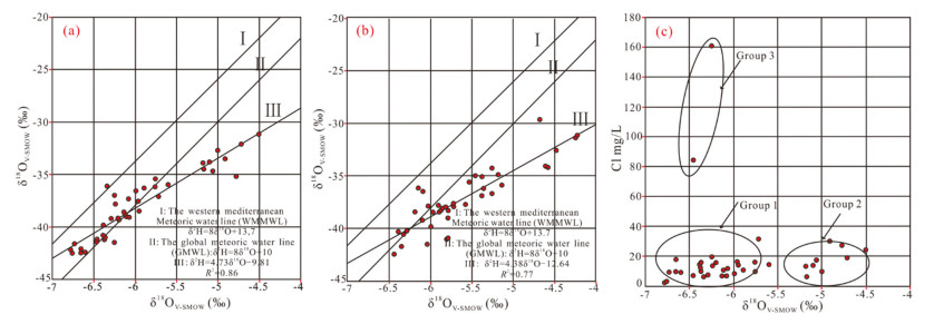
In the alluvial aquifers of Upper and Middle Cheliff (North-West Algeria), the groundwater quality is deteriorating. The objective of this study was to characterize the physical and chemical properties of these aquifers; and to evaluate the groundwater quality and its appropriateness for drinking and agricultural use. An investigation was carried out by estimating of the physiochemical parameters (Ca2+, Mg2+, Na+, K+, Cl-, SO42-, HCO3-, NO3-, Br- and TDS) to identify the chemical characteristics of groundwater. Morever, the isotopic composition was examined to identify the sources of recharge of these aquifers. The groundwater geochemistry for the high water level (May, 2012 and June, 2017) and low water level (November, 2012 and October, 2017) was studied. Accordingly, water samples from 39 water sampling points were collected (October, 2017 and June, 2018), for the purpose of analyzing stable isotopes (18O, 2H). The results show that the groundwater is mainly characterized by Ca-Cl and Na-Cl type. The chemical quality of the water is from fair to poor with the presence of nitrates used in agricultural and urban discharge. Also, the Br/Cl ratio gives indications on the origin of the salinity. This salinity is due to the leaching of chlorinated fertilizers, the dissolution of evaporite deposits and the rise of deep salty water by the fault of Chellif. While, the diagram of δ2H=f18O) indicates that the origin of the recharge of these aquifers is the Atlantic and Mediterranean oceanic meteoric rainwater.
Quantification of the Mixture of Hydrothermal and Fresh Water in Tectonic Valleys
Janete Moran-Ramírez, José Iván Morales-Arredondo, Maria Aurora Armienta-Hernández, José Alfredo Ramos-Leal
2020, 31(5): 1007-1015. doi: 10.1007/s12583-020-1294-x
Abstract:
This study was conducted to identify the origin, hydrogeochemical processes and evolution of groundwater in a tectonic valley. This study was carried out with the aim of quantifying the proportions of groundwater flows contributing to the water chemistry abstracted in a zone of convergence favored by the presence of active faults. The study area is located in the Trans-Mexican Volcanic Belt. End members methodology was applied to identify the mixing of hydrothermal with fresh groundwater, where changes in the aquifer geology result in distinct groundwater chemical signatures. Ternary mixing was quantified using conservative elements. Moreover, other evolutionary processes, such as ion exchange and silicate weathering occur due to changes in the geology of the area. In ternary mixing, each of the end members is associated with the lithology through which it circulates. The local flow contributes 70% of the water to the system, the intermediate flow contributes 14%, and the regional flow contributes 16%. Three types of water are produced:Na-HCO3, due to the interaction of water with volcanic rocks of rhyolitic composition, Na-Mg-HCO3, due to the interaction of water with volcanic rocks of basaltic-andesite composition, and Ca-HCO3, due to the interaction of water with sedimentary calcareous rocks.
Surface Water and Groundwater Interactions in Wetlands
Xiancang Wu, Teng Ma, Yanxin Wang
2020, 31(5): 1016-1028. doi: 10.1007/s12583-020-1333-7
Abstract:
Wetland ecosystems are critical habitats for various types of wild lives and are important components of global ecosystem. However, with climate change and human activities, wetlands are facing with degradation. Surface water and groundwater (SW-GW) interactions play an essential role in matter and energy cycling in wetlands, and therefore affect the evolution and health of wetlands. But the role of groundwater in wetland ecosystems has been neglected or simplified. In this paper, we reviewed how surface water interacts with groundwater, and made a systematic summarization of the role of SW-GW interactions (such as maintaining water balance and biological diversity and removing pollution) in wetland ecological functions. We also reviewed the methods to investigate, simulate and quantify SW-GW interactions and related reactions. Finally, we illustrated how climate change and human activities affect SW-GW interactions and therefore affect wetland functions. We highlight the importance of groundwater in wetlands and the urgency to intensify the research in integrated multidisciplinary monitoring and simulation methods, dominant variables and thresholds and integrated water resources management of SW-GW interactions, and further aim to stimulate better protection and restoration of wetlands all over the world.
A 2000 Year Multi-Proxy Evidence of Natural/Anthropogenic Influence on Climate from the Southwest Coast of India
M. C. Manoj, Jyoti Srivastava, Prem Raj Uddandam, Biswajeet Thakur
2020, 31(5): 1029-1044. doi: 10.1007/s12583-020-1336-4
Abstract:
The last millennium climate reconstructions are complex and limit our understanding of the mechanisms behind environmental and climate variability. We present multi-proxy centennial-scale records from the Cherai, southwest India. The last 2000 cal yr AD record suggests a complex environmental condition that prevailed at the depositional site augmenting the role of natural as well as anthropogenic agents. Increased elemental variations and indices values indicate stronger weathering, presumably wetter conditions and intense precipitation. Provenance studies suggest diverse sources and the main composition fall close to the Charnockite and Gneissic composition. Multi-proxy data suggests that a shift towards wetter climatic conditions, which occurred from 910 to 1230 cal yr AD. The core also records a shift towards the drier conditions that started around 1230 cal yr AD with a loss in vegetation diversity. The pollution load index values suggest that the overall study area falls in moderate contamination levels, which are also substantiated with the diatom data indicating human influence in the natural habitat during the deposition time. The present study reveals that the enhanced Cd and As concentration is due to strong anthropogenic influence. We compared the multi-proxy record with other continental and marine palaeoclimatic records to explore global and/or regional trends in climate variability during the last 2000 years.
Compaction Simulator: A Novel Device for Pressure Experiments of Subsurface Sediments
Yanjun Liu, Teng Ma, Juan Chen, Ziqi Peng
2020, 31(5): 1045-1050. doi: 10.1007/s12583-020-1334-6
Abstract:
Increasing overburden pressure is a key factor that alters the chemical and physical properties of soils and sediments. However, limited information is presently available on how aquifer compression impacts water quality. We introduced a novel compaction device, which is composited of four parts, including pressure simulator reactor system (PSRS), gas-liquid separator (GLS), automatic collector (AC) and composite control system (CCS). We conducted experiments at various pressures to test the functionality and outcomes of the device. In general, this device can be used to examine changes in water chemistry associated with aquifer compression resulting from compaction (overburden pressure) or groundwater overdraft.