Advanced Search

Indexed by SCI、CA、РЖ、PA、CSA、ZR、etc .

2020 Vol. 31, No. 4

CONTENTS
CONTENTS
2020, 31(4): .
Abstract:
Mineralogy·Petrology·Mineral Deposits
Fluid Evolution and Scheelite Precipitation Mechanism of the Large-Scale Shangfang Quartz-Vein-Type Tungsten Deposit, South China: Constraints from Rare Earth Element (REE) Behaviour during Fluid/Rock Interaction
Runsheng Chen, Lüyun Zhu, Shao-Yong Jiang, Ying Ma, Qinghai Hu
2020, 31(4): 635-652. doi: 10.1007/s12583-020-1283-0
Abstract:
Unlike classic skarn-type scheelite deposits directly acquiring sufficient Ca2+ from surrounding limestones, all of the scheelite orebodies of the Shangfang tungsten (W) deposit occur mainly in amphibolite, and this provides a new perspective on the mineralization mechanism of W deposits. The ability of hydrothermal scheelite (CaWO4) to bind REE3+ in their Ca2+ crystal lattices makes it a useful mineral for tracing fluid-rock interactions in hydrothermal mineralization systems. In this study, the REE compositions of scheelite and some silicate minerals were measured systematically in-situ by laser ablation inductively coupled plasma mass spectrometry (LA-ICP-MS) to assess the extent of fluid-rock interactions for the Late Mesozoic quartz-vein-type Shangfang W deposits. According to the variations in CaO and REE among scheelite and silicate minerals, the amphibole and actinolite in amphibolite may be able to release large amounts of Ca2+ and REE3+ into the ore-forming fluids during chlorite alteration, which is critical for scheelite precipitation. Furthermore, an improved batch crystallization model was adopted for simulating the process of scheelite precipitation and fluid evolution. The results of both the in-situ measurements and model calculations demonstrate that the precipitation of early-stage scheelite with medium rare-earth elements (MREE)-rich and [Eu/Eu*]N < 1. The early-stage scheelite would consume more MREE than LREE and HREE of fluid, which will gradually produce residual fluids with strong MREE-depletion and[Eu/Eu*]N>1. Even though the partition coefficient of REE is constant, the later-stage scheelite will also inherit a certain degree of MREE-depletion and [Eu/Eu*]N future from the residual fluids. As a common mineral, sheelite forms in various types of hydrothermal ore deposits (e.g., tungsten and gold deposits). Hence, the improved batch crystallization model is also possible for obtaining detailed information regarding fluid evolution for other types of hydrothermal deposits. The results from model calculations also illustrate that the Eu anomalies of scheelite are not an effective index correlated to oxygen fugacity of fluids but rather are dominantly controlled by the continuous precipitation of scheelite.
Geochemistry of the Mesoproterozoic Intrusions, Geochronology and Isotopic Constraints on the Xiaonanshan Cu-Ni Deposit along the Northern Margin of the North China Craton
Zhiguang Zhou, Jiangwei Wu, Yi Niu, Guosheng Wang, Chen Wu, Changfeng Liu, Juncheng Ju
2020, 31(4): 653-667. doi: 10.1007/s12583-020-1296-8
Abstract:
Mesoproterozoic magma events in the Bayan Obo rift belt have remained poorly constrained and as a result, the Late Paleoproterozoic-Mesoproterozoic tectonic evolution of the rift belt has remained unclear. By a multiple-facetted regional geological investigation of this belt, we have resolved the stratigraphic sequence and geochronology of the Bayan Obo Group and made new discoveries including a three-stage mantle-derived magmatic sequence. Zircon and baddeleyite dating of Xiaonanshan hornblende pyroxenite emplaced into the Bayan Obo Group yields 207Pb/206Pb ages of ca. 1.34 and 1.33 Ga. The geochronological, geochemistry, Hf isotopic analyses place an important constraint on ages of the Late Paleoproterozoic-Mesoproterozoic strata and the evolution of the rift belt. Our field observations and U-Pb dating results suggest that mineralization is genetically related to Mesoproterozoic magmatism in North China Craton, i.e., 1.33-1.34 Ga. The δ34SV-CDT values of sulphide from the ore-bearing ultra-/mafic samples are about 6.2‰, whereas the 206Pb/204Pb, 207Pb/204Pb, and 208Pb/204Pb values vary in the ranges of 17.598-18.115, 15.496-15.501, and 37.478-37.952, respectively. The Late Paleozoic mafic gabbro and acidic granite porphyry intrusions are possible to bimodal magmatic event related to the extensional tectonic setting of the Central Asia in this period.
A New Discovery of Ag-Pb-Zn Mineralization via Modern Portable Analytical Technology and Stream Sediment Data Processing Methods in Dajiacuo Area, Western Tibet (China)
Xiaojia Jiang, Xin Chen, Shunbao Gao, Youye Zheng, Huan Ren, Denghui Han, Chenchen Yan, Junsheng Jiang
2020, 31(4): 668-682. doi: 10.1007/s12583-020-1323-9
Abstract:
Tibet, which is rich in mineral resources, is a treasure trove for geological explorers. However, prospecting work has been slow, especially in the western part, due to the precipitous terrain, changeable climate and low access. Hence, modern advanced field analytical technology and effective data processing methods play significant roles in rapid and efficient exploration in Tibet. In this paper, spectrum-area fractal modeling and portable X-ray fluorescence analysis (pXRFA) were used to identify and verify geochemical anomalies associated with Ag-Pb-Zn mineralization based on a stream-sediment dataset of 39 elements in the Dajiacuo-Xurucuo region of western Tibet. First, staged factor analysis (SFA) was used to obtain the Ag-Pb-Zn-Cd geochemical assemblage. Second, the first-factor pattern obtained using SFA was dissociated by a spectrum-area (S-A) fractal model and a digital elevation model (DEM)-based geochemical model (DGM) was constructed. Finally, the sections of Ag, Cd, Pb, and Zn were obtained using pXRFA. The results show that Ag-Pb-Zn-Cd enrichment zones were mostly located around the contact belt of volcanic rocks and intrusions, or along SE-NW trending faults. Considering the variable terrain and catchment basin, the extension of long axes of Ag-Pb-Zn-Cd anomalies into higher elevation areas that are favorable for Ag-Pb-Zn mineralization should be investigated. Anomaly maps created with the aid of a DGM show promising potential for mineralization in the Dajiacuo-Xurucuo region, and abundant Ag-Pb-Zn mineralization was identified with the assistance of pXRFA in the source areas for the geochemical anomalies in the Dajiacuo. We conclude that SFA and the S-A fractal model constitute a valid tool to identify or verify geochemical anomalies in areas of low-density stream-sediment sampling. The pXRFA can accurately determine the source of geochemical anomalies and improve anomaly verification efficiency.
Electrical Conductivity of Eclogite, Amphibolite and Garnet-Quartz-Mica Schist with Implications for the Conductivity in the Qiangtang Terrane of Northern Tibetan Plateau
Yi Cao, Xinzhuan Guo, Jinxue Du
2020, 31(4): 683-692. doi: 10.1007/s12583-020-1290-1
Abstract:
Understanding the electrical conductivity of high pressure metamorphic rocks is essential to constrain the compositions in the subduction zone and continental crust. In this study, we calculated the electrical conductivity for such rocks sampled from the central Qiangtang metamorphic belt in the northern Tibetan Plateau. The results reveal that, when aqueous fluids are absent, the conductivity of meta-mafic rocks (e.g., eclogite and amphibolite) is strikingly higher than that of meta-felsic rocks (e.g., garnet-quartz-mica schist). The conductivity of eclogite decreases due to the enrichment of amphibole, but this effect is diminished when a critical degree of amphibolization is reached. Our calculated conductivity of eclogite and amphibolite differs greatly from the experimentally derived results for the eclogites from other localities, partly owing to the strong effects of different mineral assemblages and chemical compositions on the conduction mechanisms and efficiencies. However, the disparity of conductivity between our calculated and the previously measured results for a similar amphibole-rich eclogite sampled from the same locality suggests that trails of highly conductive rutile-ilmenite aggregates may contribute to the higher bulk-rock conductivity in the laboratory measurements. Moreover, since the calculated conductivity of eclogite and amphibolite is not high enough at the temperatures relevant to their metamorphic thermal condition, partial melts or aqueous fluids originated from the upwelling asthenosphere are more likely to explain the anomalously high electrical conductivity zones in magnetotelluric images in the Qiangtang terrane in the northern Tibetan Plateau.
Petrogenesis of the Granites in the Yandangshan Area, Southeastern China: Constraints from SHRIMP U-Pb Zircon Age and Trace Elements, and Sr-Nd-Hf Isotopic Data
Yaqin Luo, Haiyan Qin, Tao Wu, Zilong Li
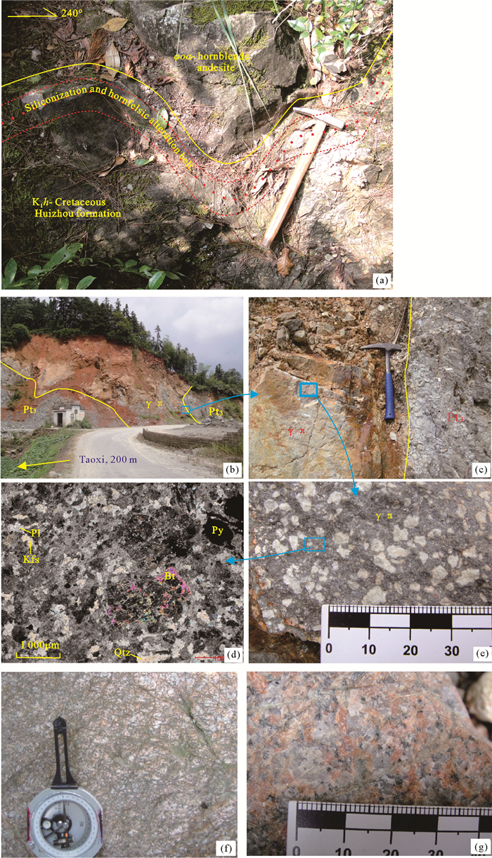
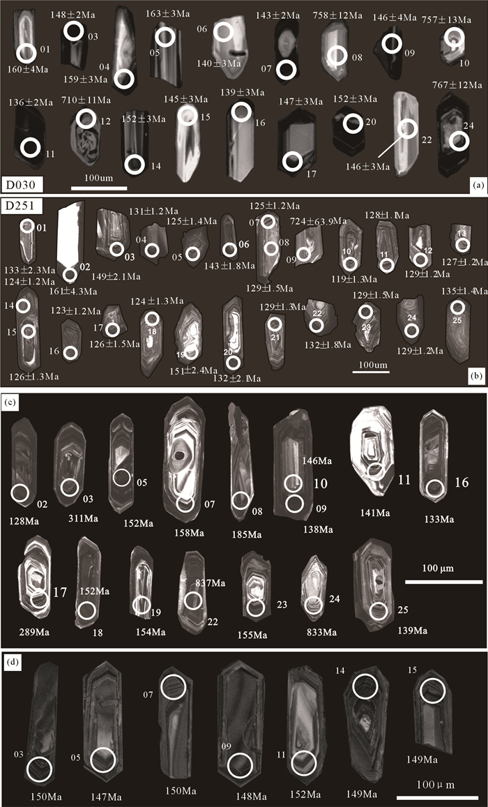
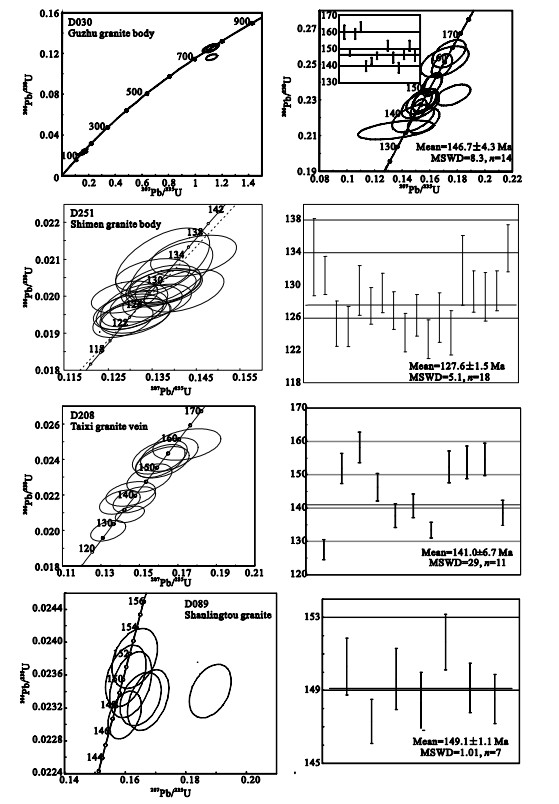
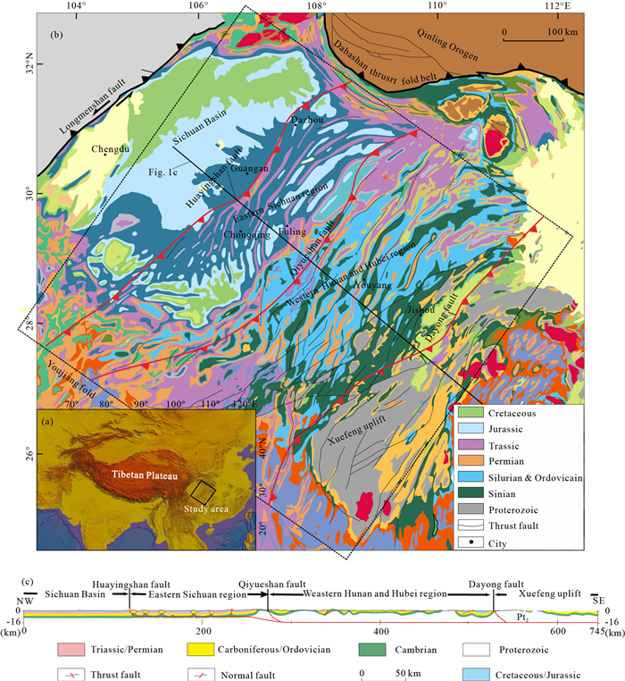
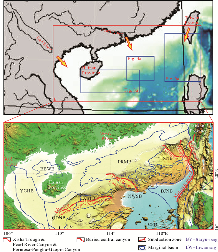
2020, 31(4): 693-708. doi: 10.1007/s12583-020-1295-9
Abstract:
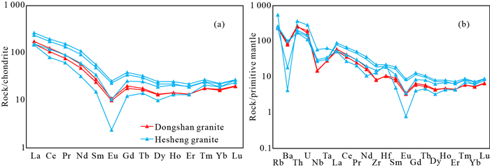
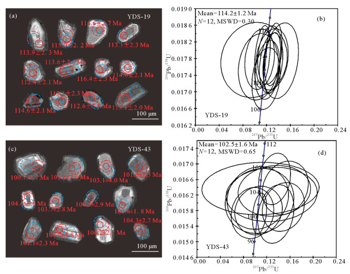
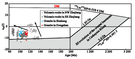
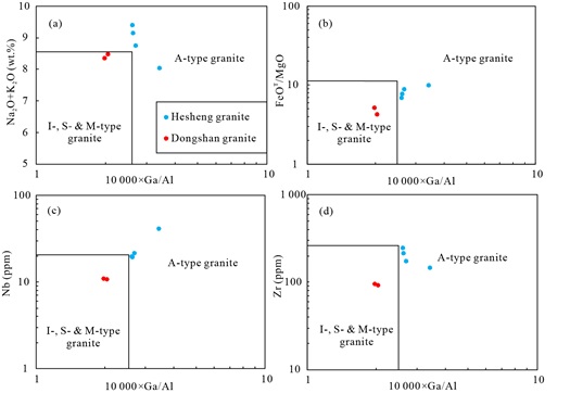
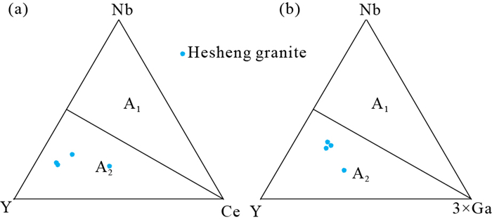
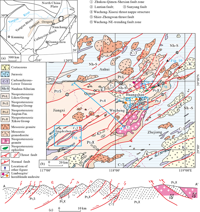
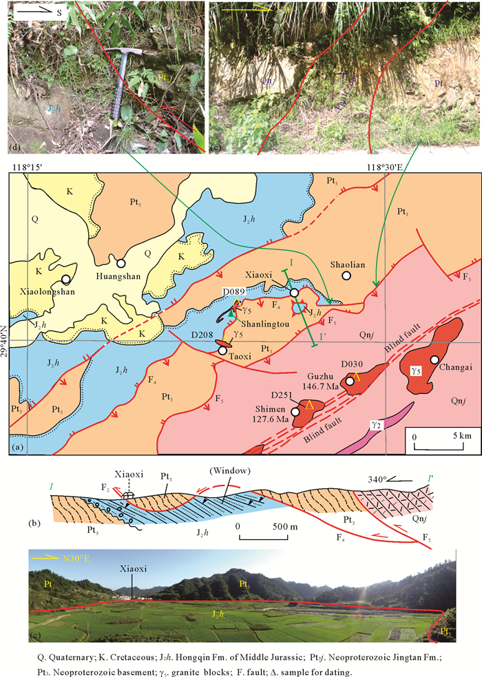
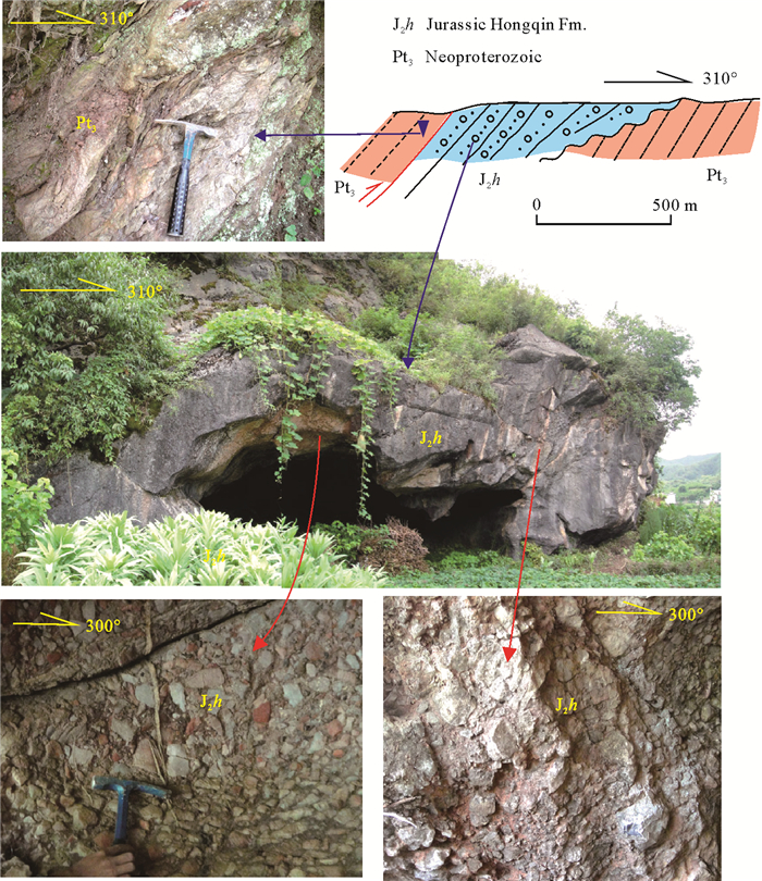
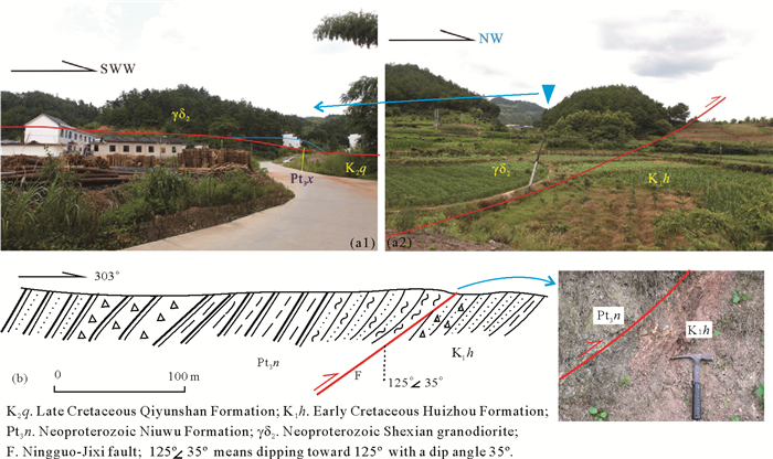
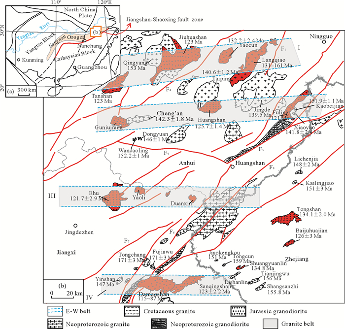
New geochemical and geochronological data of two types of granites, which are located in Yandangshan area, southeastern Zhejiang Province, were presented to constrain their magma condition, origin and the genetic relationship between them. The SHRIMP zircon U-Pb dating of Dongshan and Hesheng granite in Yandangshan area shows that they were formed at 114±1 and 103±2 Ma, respectively. Samples from the Dongshan granite have high SiO2 (76.4 wt.%-76.9 wt.%) and total alkaline (K2O+Na2O=8.35 wt.%-8.47 wt.%) contents, but low FeOT (0.89 wt.%-1.15 wt.%), MgO (0.21 wt.%-0.22 wt.%), and CaO (0.24 wt.%-0.34 wt.%) contents and high A/CNK (~1.1) values, belonging to the peraluminous and magnesian granite. The Hesheng granite has high SiO2 (72.2 wt.%-77.5 wt.%), total alkaline (K2O+Na2O=8.05 wt.%-9.41 wt.%) and FeOT contents (1.20-2.06), and high A/CNK values (1.0-1.1), but low in MgO (0.12 wt.%-0.29 wt.%) and CaO (0.24 wt.%-0.34 wt.%) contents. Samples from the Hesheng granite also have high FeOT/MgO (6.9-10.0) and 10 000×Ga/Al (2.6-3.4) ratios similar to the ferroan/A-type granite. All the samples are enriched in LREE but have produced negative Eu anomalies (Eu/Eu*Dongshan=0.45-0.47; Eu/Eu*Hesheng=0.17-0.55), Ba, Nb, and Ta, while the REE contents of the ferroan/A-type granite (Hesheng) are higher than that of the magnesian granite (Dongshan). The (87Sr/86Sr)i value of the magnesian granite is slightly higher than that of the ferroan/A-type granite and its εNd(t) value (-6.8) is lower than the latter (-6.0--5.9). In addition, the εHf(t) value (-11.8--4.2) of magnesian granite is also lower than that of the ferroan/A-type granite (-8.3--2.0), indicating that there may be more mantle-derived components in the source area of the ferroan/A-type granite. Zircon saturation thermometer (TZr) and Ti-in-zircon thermometer (TZircon) are used to estimate the temperature of the magma source, and the results show that the magma temperature of the magnesian granite (average TZr=798℃; average TZircon=792℃) is lower than that of the ferroan/A-type granite (average TZr=862℃; average TZircon=859℃). And the oxygen fugacity of magnesian granite (ΔFMQ=1.16-3.47) are also higher than those of the ferroan/A-type granite (ΔFMQ=-0.41-1.14). Our new data indicate that both granites in this study are derived from a mixed source that consists of mantle-derived and crust-derived material. Based on the previous studies, both of the granitic plutons were formed under extension setting, and the granites transformed from magnesian to ferroan in the study area may indicate the extension was enhanced, which may be caused by the roll-back or delamination of the Paleo-Pacific oceanic slab.
Experimental Constraints on Formation of Low-Cr# Chromitite: Effect of Variable H2O and Cr2O3 on Boninitic-Magma and Harzburgite Reactions
Yage Zhao, Yanfei Zhang, Chao Wang, Zhenmin Jin, Qijin Xu
2020, 31(4): 709-722. doi: 10.1007/s12583-020-1291-0
Abstract:
Reactions between a boninitic or basaltic magma and harzburgite at shallow mantle depths are thought to be closely related to the formation of podiform chromitites, but little experimental data is available on these reactions. In this study, a series of experiments were conducted at 1.5 GPa and 1 000-1 400 oC to investigate the interactions between boninitic magma and harzburgite in homogenous mixed systems with varied bulk concentrations of water (~0.7 wt.%-10 wt.%) and Cr2O3 (~0.2 wt.%-4 wt.%). In the experimental charges, chromite grains can be observed coexisting with orthopyroxene, clinopyroxene±olivine, and quenched melt in the Cr-bearing systems. The bulk concentration of Cr2O3 in the starting material has a slight effect on compositional changes in the chromites generated. However, the Cr# (Cr#=100×Cr/(Cr+Al)) and Mg# (Mg#=100×Mg/(Mg+Fe)) values for the chromites exhibit positive and negative correlations, respectively, with the bulk H2O concentrations. At 1 100 oC, chromite Cr# values range from ~33-35 to ~58-65, and chromite Mg# values range from ~70-73 to~55-58 when bulk H2O contents in the starting material are increased from ~0.7 wt.% to ~10 wt.%. The experimentally produced chromites have compositions (as expressed by Cr#, Mg#, and NiO and MnO contents) similar to natural chromites from low-Cr# chromitite bodies. We suggest that the interactions between boninitic magmas with varied H2O contents and harzburgite in a shallow mantle wedge could be a possible mechanism that forms the low-Cr# chromitites found in ophiolites. We emphasize here that H2O may play an important role in the compositional evolutions of natural chromitites.
Geotectology
Late Cenozoic Activity of the Tashkurgan Normal Fault and Implications for the Origin of the Kongur Shan Extensional System, Eastern Pamir
Shenqiang Chen, Hanlin Chen
2020, 31(4): 723-734. doi: 10.1007/s12583-020-1282-1
Abstract:
In the northwest of the Himalayan-Tibetan Orogen, the ~250 km-long Kongur Shan extensional system in the eastern Pamir was formed during the convergence between the Indian and Asian plates. Tectonic activity of the Kongur Shan normal fault and the Tashkurgan normal fault can help to reveal the origin of east-west extension along the Kongur Shan extensional system. The Kongur Shan fault has been extensively studied, while the Tashkurgan fault calls for systemic research. In this study, low-temperature thermochronology including apatite fission track analysis and apatite and zircon (U-Th)/He analyses is applied to constrain the timing of activity of the Tashkurgan fault. Results indicate that the Tashkurgan fault initiated at 10-5 Ma, and most likely at 6-5 Ma. The footwall of the Tashkurgan fault has been exhumed at an average exhumation rate of 0.6-0.9 mm/a since the initiation of the Tashkurgan fault. Combined with previous research on the Kongur Shan fault, we believe that the origin of east-west extension along the Kongur Shan extensional system was driven by gravitational collapse of over-thickened Pamir crust.
Cenozoic Uplift of the Central Yunnan Fragment, Southwestern China, Revealed by Apatite (U-Th)/He Dating
Ke Wu, Youpu Dong, Jiaxin Duan, Xin Ru, Dongyue Zhang, Dan Wang
2020, 31(4): 735-742. doi: 10.1007/s12583-020-1328-4
Abstract:
The age of central Yunnan fragment uplift has long been debated, with estimates ranging from the Late Eocene to about 1 Ma. To determine the central Yunnan fragment uplift time in the Cenozoic, apatite (U-Th)/He (AHe) was used to analyze the low-temperature thermochronology of samples from the Jiaozi Mountain area of the eastern central Yunnan fragment. The sampling area is located in the Dongchuan District of Kunming, Yunnan Province, near the Xiaojiang fault zone. The results show that AHe ages from the eastern part of central Yunnan fragment were mainly concentrated around 25.7-37.9 Ma, and intensive uplift had happened before 36.5 Ma. Together with previous low-temperature thermochronology research on the western and eastern central Yunnan fragment, we concluded that the Yunnan Plateau uplifted prior to 36.5 Ma, in a west to east sequence. The uplift caused a change in paleo-geographical terrain, which may have altered the ancient river systems of the southeast Tibetan Plateau.
Tectonic Evolution of Southeast Central Asian Orogenic Belt: Evidence from Geochronological Data and Paleontology of the Early Paleozoic Deposits in Inner Mongolia
Shijie Wang, Shichao Li, Wenjie Li, Zhongyuan Xu, Jinfeng Zhang, Changhai Li, Qiang Shi, Yang Liu, Wenlong Wang, Qingbin Guan
2020, 31(4): 743-756. doi: 10.1007/s12583-020-1326-6
Abstract:
In this study, we present detrital zircon U-Pb dating and paleontological data for the newly identified Ayadeng Formation in the northern margin of the North China Block (NCB) and Xibiehe Formation (molasse) in the Bainaimiao arc belt (BAB), which could provide strong evidence indicating the affinity of the BAB and the evolution of the southeast Central Asian orogenic belt (CAOB). Zircon U-Pb data of siltstone samples and paleontological data indicate the Ayadeng Formation dates back to the Early Ordovician. Although its location is near the NCB, its zircon age spectra and paleontology share a closer affinity with those of Tarim and NE Gondwana, as the U-Pb data suggest an age range of 490-2 192 Ma (peak age=629, 788, 965 and 1 935 Ma), and similar gastropod fossils are found in Tarim and NE Gondwana. The U-Pb ages of meta-sandstone samples in the Xuniwusu Formation indicate a shared inheritance with the Ayadeng Formation (before 440 Ma), and the U-Pb ages of sandstone samples in the Xibiehe Formation are concentrated, with age peaks centered at ca. 420 Ma. Fossil corals occur in these two formations, and their age components also indicate a collisional setting. Therefore, it is speculated that the BAB drifted away from Tarim or NE Gondwana during the Ordovician and became attached to northern NCB between 440-420 Ma as an exotic terrane. During the Early Paleozoic, there may have occurred a collision between an arc and a continental block.
Provenance Analyses of Lower Cretaceous Strata in the Liupanshan Basin: From Paleocurrents Indicators, Conglomerate Clast Compositions, and Zircon U-Pb Geochronology
Xiaochen Zhao, Chiyang Liu, Jianqiang Wang, Wei Luo, Fangpeng Du, Li Ma
2020, 31(4): 757-771. doi: 10.1007/s12583-020-1324-8
Abstract:
The Liupanshan Basin constitutes a major portion of the northern North-South tectonic belt. The Lower Cretaceous strata in the Liupanshan Basin recorded the tectono-sedimentary evolution processes of this area and are pivotal for understanding the original sedimentary appearance of the Liupanshan Basin. In this work, we present a study of provenance and tectono-sedimentary evolution of the Liupanshan Basin during the Early Cretaceous. Integrated-paleocurrent directions, gravel clast compositions, and detrital zircon U-Pb isotopic analysis of the Lower Cretaceous Sanqiao and Heshangpu formations were applied to determine the provenance. The gravel clast compositions of Sanqiao Formation conglomerates (mainly including magmatic rocks, metamorphic rocks and limestones) display various features in different places, revealing different rock components of source areas. The paleocurrent directions of the Sanqiao and Heshangpu formations suggest that the sediments were transported from the basin margin to the center. Detrital zircons of two samples from the Huoshizhai Section (northwestern Liupanshan Basin) yield a dominant unimodal distribution from 420 to 500 Ma, suggesting a single-sourced provenance. Based on the above analyses, comparing to the magmatic records in the Qilian-Qinling orogenic belt, the detritus of the Sanqiao and Heshangpu formations were mainly from the proximal metamorphic and magmatic rocks of the Qilian-Qinling orogenic belt and the limestones of the archaic uplift. Combined with sedimentary characteristics, we concluded that the Liupanshan Basin experienced multi-stage evolution history:(1) the early rifting extension stage (Sanqiao Period), (2) the middle spanning and depression stage (Heshangpu-Early Naijiahe Period), and (3) the late extinction stage (Late Naijiahe Period). The evolution of Liupanshan Basin is closely related to that of Ordos Basin and it is further associated with tectonic transition of the northern North-South tectonic belt.
Mesozoic Thrust-Nappe and Extensional Structure Frameworks in the East Segment of Southeast Yangtze Block, Southeast China
Xinqi Yu, Ziwei Chen, Jun Hu, Yan Zeng, Xiu Liu, Yu He, Zishen Wang, Linghui Meng
2020, 31(4): 772-794. doi: 10.1007/s12583-020-1292-z
Abstract:
Multi-stage Mesozoic thrust-nappe and extensional structures are distributed in the east segment of the Southeast Yangtze Block situated in the junction region of Zhejiang-Jiangxi-Anhui provinces. The features and genetic mechanism of the deformations were analyzed after a detailed field observation of their distribution, geometry, and kinematics. In addition, the time sequences of the thrust and extensional structures were determined by combining the results of the comparative analysis with the chronological evidence of strata and magmatic rocks cut by a fault or formed after a fault according to field facts. This study identified three stages of the nappe structures and at least two stages of the extensional structures during the Mesozoic. The geotectonic setting of the nappe and extensional structures was considered to be related to the different geodynamics in the study area including the Early Mesozoic geological event, i.e., N-S compression, forming Lantian fault, etc.; the Late Mesozoic flat-slab subduction, forming Xiaoxi thrust fault and tectonic window; and the roll-back of the paleo-Pacific Plate, forming extensional structures like basin marginal fault; the last compression, forming Wucheng-Shenxian fault. These findings provide additional evidence for remodeling the tectonic and geodynamic evolution of Southeast China.
Influence of Mechanical Stratigraphy on the Deformation Evolution of Fold-Thrust Belts: Insights from the Analogue Modeling of Eastern Sichuan-Western Hunan and Hubei, South China
Wengang He
2020, 31(4): 795-807. doi: 10.1007/s12583-020-1281-2
Abstract:
The eastern Sichuan-western Hunan and Hubei belt (ESWHHB) is an important fold-thrust belt in the Middle-Upper Yangtze region of China, and it is also an important area for petroleum and gas prospect in China. The influence of mechanical stratigraphy on the deformation evolution of the ESWHHB is a hot problem that has received widespread attention. However, due to the complexity of geological conditions, this issue has not been sufficiently addressed. Previews geological exploration studies show that the deformation evolution of the belt is closely related to the mechanical stratigraphy. Physical simulation has proven to be effective for studying the deformation evolution of fold-and-thrust belt. Based on the geological conditions of the ESWHHB, six groups of physical models were designed to analyze the influences of the ductile layer and overlap configuration on the structural deformation of the ESWHHB. The results show that the mechanical stratigraphy has significant control on the deformation evolution of the fold-thrust belt. The ESWHHB evolution is related to the lower viscosity of the ductile layer and the larger thickness of the ductile layer, while only gradual propagated fold-and-thrust belt can be resulted from the higher viscosity of the ductile layer and the smaller thickness of the ductile layer. Additionally, the overlap between the stratigraphy at various structural belts leads to significant differences in their mechanical properties, and it critically influences the structural patterns of the ESWHHB.
Marine Geology
Depositional Characteristics and Formation Mechanisms of Deep-Water Canyon Systems along the Northern South China Sea Margin
Hui Chen, Xinong Xie, Kainan Mao, Yunlong He, Ming Su, Wenyan Zhang
2020, 31(4): 808-819. doi: 10.1007/s12583-020-1284-z
Abstract:
Submarine canyon systems are sites for coarser clastic sediment accumulations in the deep-water domains, having the most potential for hydrocarbon reservoirs. Based on the interpretation of high resolution 2D/3D seismic and drilling data, depositional characteristics of three large deep-water canyon systems on the South China Sea northern margin have been analyzed. The Central Canyon System has a deep incision geomorphology extending from east to west, featured by distinct canyon segmentations, multi-provenance sediment supplies and multi-stage canyon fillings. The Pearl River Canyon System's formation is closely related to the development of Pearl River Delta. Its vertical stacking and migrating canyon patterns have changed over time. The depositional architectures and evolution of the recent Penghu-Gaoping Canyon System respond to tectonic movements along the Taiwan-Luzon convergent continental margin. The main controlling factors of the formation and evolution of these three canyon systems include the tectonic setting, sediment supply, sea level change and paleo-geomorphology, among which the former two are dominant. The Penghu-Gaoping Canyon System formed along the subduction structural zone, directly indicating a typical tectonic origin. Numerous seismic data show that the Central Canyon and Pearl River Canyon systems are obviously affected by tectonics, associated local topography and sediment supply.
Coupling Relationship between Shelf-Edge Trajectories and Slope Morphology and Its Implications for Deep-Water Oil and Gas Exploration: A Case Study from the Passive Continental Margin, East Africa
Mengtian Gao, Shang Xu, Haiteng Zhuo, Yuxuan Wang, Shaobo Wu
2020, 31(4): 820-833. doi: 10.1007/s12583-020-1288-8
Abstract:
Both the shelf-edge trajectories and slope morphology are indicative of deep-water sedimentation, but previous studies are relatively independent from each other in the two dimensions. An integrated investigation can enhance the understanding of deep-water sedimentary systems and enrich reservoir prediction methods. Based on the bathymetry data and seismic data published, this study identified ten slope areas at the continental margin of East Africa and classified the clinoforms into three types:concave-up, sigmoidal and planar. Combined with the distribution of main modern rivers in East Africa, nine modern source-to-sink systems were identified and the catchment area is positively correlated with the size of the shelf-edge delta. It is found that the slope morphology of East Africa is closely related to the geological setting, sediment supply and sediment transport pathway in submarine canyon of passive continental margin. When the sediment supply is stable, the concave-up slopes are dominated by the river-associated and shelf-incising canyons and the sigmoidal slopes are determined by the headless canyons. There exists a strong coupling relationship between the shelf-edge trajectories and slope morphology. In general, concave-up slopes correspond to descending trend, flat and low-angle ascending trend shelf-edge trajectories and high-quality reservoirs developed on the basin floor under the influence of river-associated and shelf-incising canyons which have bright prospects for oil and gas exploration. Additionally, sigmoidal slopes usually correspond to descending trend, flat and low-angle ascending trend shelf-edge trajectories at times of relative sea-level fall and the reservoirs mostly developed on the upper slope under the influence of headless canyons. Moreover, the planar slopes correspond to high-angle ascending trend trajectories which are hardly potential for exploration. The coupling model built in this study will provide an insight for oil and gas exploration in deep-water areas with limited data and low exploration degree.
Environmental Geochemistry and Environmental Geo-hazards
The Environmental Functions and Ecological Effects of Organic Carbon in Silt
Rui Liu, Teng Ma, Wenkai Qiu, Ziqi Peng, Chenxuan Shi
2020, 31(4): 834-844. doi: 10.1007/s12583-020-1349-z
Abstract:
Silt is a kind of unconsolidated sediment consisting of fine particles; silt is generally deposited across wide areas on the surfaces of drainages and in oceans under static or slow-hydrodynamic conditions. The organic carbon (OC) in silt has multiple essential environmental functions. This paper elaborates the morphological and environmental indication functions of OC in silt, and the effect of its own migration and transformation on environmental deterioration. Organic carbon exists in silt in two forms, free and mineral-binding. Meanwhile, based on its formation and structure, OC can be divided into light and heavy fraction of OC. Environmental information including data related to paleoclimates, ancient levels of productivity level, and variations in regional organism abundance can be discovered from total organic carbon, the C/N ratio, and OC isotope content. Degradation of OC is believed to participate in the emission of greenhouse gases, release of heavy metals and other contaminants. Finally, from the view of silt deposition, the possible influence of complex water-rock interaction in which OC is involved during the evolution of silt to a clayey aquitard on the hydrochemical composition of groundwater is discussed, which provides a new perspective for future research on the carbon cycle in nature.
Habitat Influence on the Molecular, Carbon and Hydrogen Isotope Compositions of Leaf Wax n-Alkanes in a Subalpine Basin, Central China
Chaoyang Yan, Yiming Zhang, Yanzhen Zhang, Zhiqi Zhang, Xianyu Huang
2020, 31(4): 845-852. doi: 10.1007/s12583-020-1322-x
Abstract:
Epidermal leaf waxes of terrestrial higher plants have been widely utilized for the reconstructions of paleoenvironment and paleoclimate in peat deposits. In this study, specimens of four plant species growing in both peatland and non-peatland habitats were retrieved to compare their molecular, carbon (δ13C) and hydrogen (δ2H) isotopic compositions of leaf wax n-alkanes from a closed subalpine basin in Central China. Three of the four species show quite higher total concentrations of n-alkanes in the relatively dry non-peatland setting than in the peatland. In addition, the δ2H values of long-chain n-alkanes are generally less depleted in the peatland and are comparable among different plant species, which is interpreted as the influence of inundation condition and the possible limited supply of photosynthetic products. This study reveals different patterns of plant wax molecular and isotopic compositions between peatland and the surrounding non-peatland conditions, and confirms the paleoenvironmental potential of leaf wax ratios on the peat sequences.
Landslides Triggered by the 3 August 2014 Ludian (China) Mw 6.2 Earthquake: An Updated Inventory and Analysis of Their Spatial Distribution
Weiying Wu, Chong Xu, Xiaoqing Wang, Yingying Tian, Fei Deng
2020, 31(4): 853-866. doi: 10.1007/s12583-020-1297-7
Abstract:
The 3 August 2014 Ludian, Yunnan, China Mw 6.2 (Ms 6.5) earthquake triggered a large number of coseismic landslides. Based on pre- and post-quake high-resolution optical satellite images, this study established a new, complete and objective database of these landslides with field investigations. The updated inventory shows that this earthquake triggered at least 12 817 landslides with a total occupation area of 16.33 km2, covering a nearly circular area about 600 km2, which all exceed those in our previous work and other relevant studies. In addition, we used this database to examine the correlations of the landslides with topographic, geologic, and seismic factors. Results show that the landslides occurred mostly at places with slope gradients 10°-40°, showing an increase tendency with steeper slopes. Affected by the propagation direction of the earthquake rupture, the eastward-facing slopes are more prone to landsliding. The differences between the landslide susceptibility in different strata indicate that lithology is also an important controlling factor. The landslide density of the places with peak ground acceleration (PGA) greater than 0.16g is obviously larger than those with PGA less than 0.16g. Meanwhile, the greater the distance from the epicenter, the lower the susceptibility of landslides is. This study suggests that when using satellite images to create coseismic landslide inventories, it should meet certain conditions, including high resolution, whole coverage, and timely data collection. The correct criteria of coseismic landslide inventorying also should be followed. Such inventories can provide a reliable basis for hazard assessment of earthquake-triggered landslides and other quantitative studies.