Advanced Search

Indexed by SCI、CA、РЖ、PA、CSA、ZR、etc .

2021 Vol. 32, No. 5

Display Method:
CONTENTS
2021, 32(5): .
Abstract:
Special Issue on Geo-Disasters
Preface to the Special Issue on Geo-Disasters
Chong Xu, Xiwei Xu, Yu Huang
2021, 32(5): 1053-1055. doi: 10.1007/s12583-021-1546-4
Abstract:
Landslides Triggered by the 2020 Qiaojia Mw5.1 Earthquake, Yunnan, China: Distribution, Influence Factors and Tectonic Significance
Xiangli He, Chong Xu, Wenwen Qi, Yuandong Huang, Jia Cheng, Xiwei Xu, Qi Yao, Yongkun Lu, Boyang Dai
2021, 32(5): 1056-1068. doi: 10.1007/s12583-021-1492-1
Abstract:
On May 18, 2020, an Mw5.1 earthquake occurred in Qiaojia County, Yunnan Province, China. This moderate-sized event triggered massive coseismic landslides, resulting in some damage. In this work, through visual interpretation of high-resolution (0.8-2 m) Gaofen satellite images before and after the earthquake, 167 landslides were delineated, 18 of which were inspected in the field. Using the landslide number density (LND) and landslide area percentage (LAP), we characterized the spatial distribution of these landslides, and analyzed their possible influence factors and tectonic significance. The results show that these landslides are distributed mostly in the NW-SE direction, roughly parallel to the long axis of seismic intensity zones and the strike of the Xiaohe-Baogunao fault (XBF). The LND and LAP decrease with increasing distances to the fault and from the epicenter to fault ends of the XBF. These permit to suggest that the seismogenic fault of the Qiaojia earthquake is likely a hidden branch of the XBF. All of the landslides induced by this event occurred in the region with the seismic intensity of six degrees or greater of the 2014 Mw6.2 Ludian earthquake. Therefore, it was inferred that the 2020 Qiaojia earthquake was probably the subsequent release of accumulated elastic strain after the 2014 Ludian earthquake in a same tectonic stress regime.
An Updated Database and Spatial Distribution of Landslides Triggered by the Milin, Tibet Mw6.4 Earthquake of 18 November 2017
Yuandong Huang, Chong Xu, Xiaolong Zhang, Chunji Xue, Shiyuan Wang
2021, 32(5): 1069-1078. doi: 10.1007/s12583-021-1433-z
Abstract:
The Mw6.4 earthquake on November 18, 2017 in Milin County, Nyingchi City, Tibet triggered thousands of landslides. By comparing visual interpretation of satellite images acquired shortly before and after the earthquake and field survey, we have created a new landslide database which includes 3 130 coseismic landslides, each with an area of 0.01 to 4.35 km2. Six factors (elevation, slope angle, slope aspect, lithology, distance from the epicenter and distance from the seismogenic fault) were selected to correlate with the coseismic landslides. In addition, the area and density of landslides were counted as indicators. Results show that most landslides occurred where the elevation is between 2 000-3 000 m, with a 40°-50° slope angle and S, E or SE slope aspect, schist or gneiss lithologies, 10-15 km from the epicenter, and 5 km within the seismogenic fault. Most of the landslides, triggered by the Mw6.4 earthquake, are concentrated near the seismogenic fault rather than at the epicenter, indicating that the seismogenic structure is more influential than the location of the epicenter. Our findings may differ from other landslide database due to temporal image acquisition, interference from weather, and image resolution.
Geohazard Recognition and Inventory Mapping Using Airborne LiDAR Data in Complex Mountainous Areas
Chen Guo, Qiang Xu, Xiujun Dong, Weile Li, Kuanyao Zhao, Huiyan Lu, Yuanzhen Ju
2021, 32(5): 1079-1091. doi: 10.1007/s12583-021-1467-2
Abstract:
Geohazard recognition and inventory mapping are absolutely the keys to the establishment of reliable susceptibility and hazard maps. However, it has been challenging to implement geohazards recognition and inventory mapping in mountainous areas with complex topography and vegetation cover. Progress in the light detection and ranging (LiDAR) technology provides a new possibility for geohazard recognition in such areas. Specifically, this study aims to evaluate the performances of the LiDAR technology in recognizing geohazard in the mountainous areas of Southwest China through visually analyzing airborne LiDAR DEM derivatives. Quasi-3D relief image maps are generated based on the sky-view factor (SVF), which makes it feasible to interpret precisely the features of geohazard. A total of 146 geohazards are remotely mapped in the entire 135 km2 study area in Danba County, Southwest China, and classified as landslide, rock fall, debris flow based on morphologic characteristics interpreted from SVF visualization maps. Field validation indicate the success rate of LiDAR-derived DEM in recognition and mapping geohazard with higher precision and accuracy. These mapped geohazards lie along both sides of the river, and their spatial distributions are related highly to human engineering activities, such as road excavation and slope cutting. The minimum geohazard that can be recognized in the 0.5 m resolution DEM is about 900 m2. Meanwhile, the SVF visualization method is demonstrated to be a great alternative to the classical hillshaded DEM method when it comes to the determination of geomorphological properties of geohazard. Results of this study highlight the importance of LiDAR data for creating complete and accurate geohazard inventories, which can then be used for the production of reliable susceptibility and hazard maps and thus contribute to a better understanding of the movement processes and reducing related losses.
Active Landslide Detection Based on Sentinel-1 Data and InSAR Technology in Zhouqu County, Gansu Province, Northwest China
Cong Dai, Weile Li, Dong Wang, Huiyan Lu, Qiang Xu, Ji Jian
2021, 32(5): 1092-1103. doi: 10.1007/s12583-020-1380-0
Abstract:
Zhouqu County in Gansu Province, Northwest China, is typically highly prone to landslides. On July 12, 2018, a landslide blocked the Bailong River near Zhouqu County, posing a serious threat to the life and property of local residents and the safety of infrastructure. Small baseline subset interferometry synthetic aperture radar technology (SBAS-InSAR) was adopted to identify the potential active landslides in the surrounding area of Zhouqu County, using ascending and descending orbit Sentinel-1 satellite images taken from October 2017 to December 2018. The surface deformation areas detected by SBAS-InSAR were verified by optical remote sensing image interpretation and field investigation, and a total of 23 active landslides were identified finally. The deformation characteristics of four typical landslides are analysed in detail using deformation velocity and rainfall data. It is found that the deformation velocity of landslides in this area is mainly affected by rainfall and there is a lag effect. The results can provide a reference for the prevention and control of landslide risk in Zhouqu County.
Stability Analysis of Rainfall-Triggered Toe-Cut Slopes and Effectiveness Evaluation of Pile-Anchor Structures
Xi Xu, Yuanchuang Xing, Zhen Guo, Yu Huang
2021, 32(5): 1104-1112. doi: 10.1007/s12583-021-1474-3
Abstract:
Slope toe excavation strongly influences the stress balance of natural slopes and redistributes the stress of the slope body. Consequently, the sliding failure of toe-cut slopes is increasingly becoming more frequent, particularly in regions with persistent rainfall. The effects of external factors, namely, toe excavation and persistent rainfall, which lead to toe-cut slope failure were investigated through the numerical analysis of typical toe-cut slopes in the southeastern coastal region of China. Based on the grey relational theory, sensitivity analysis was carried out on the controlling factors to determine the degree of influence exerted by the external factors on the stability of toe-cut slopes. The stability analysis of toe-cut slopes reinforced by pile-anchor structures under earthquake conditions was carried out using pseudo-static analysis. The safety factor of toe-cut slopes significantly decreases as the excavation height, rainfall duration, and rainfall intensity increase. The slope stability is more sensitive to the excavation height of a toe-cut slope than it is to rainfall. The stability of a toe-cut slope reinforced by a pile-anchor structure was also analyzed under rainfall and earthquake conditions using the limit equilibrium method and pseudo-static analysis, respectively. The slope stability significantly improved when the slope was reinforced by a pile-anchor structure, even when the slope was subjected to persistent rainfall and earthquakes. The findings of this study can provide important guidance for the prevention of geological disasters in mountainous areas.
Using Physical Model Experiments for Hazards Assessment of Rainfall-Induced Debris Landslides
Qianqian Li, Dong Huang, Shufeng Pei, Jianping Qiao, Meng Wang
2021, 32(5): 1113-1128. doi: 10.1007/s12583-020-1398-3
Abstract:
Using physical simulation models, rainfall-induced landslides have been simulated under various rainfall intensities. During these simulations, we have monitored the physical and mechanical behaviors of the landslide over the slip surface at different heights of the model slopes, as well as taking the whole slope to identify its deformation and failure processes. The results show that the rainfall duration corresponding to the initiation of the debris landslide and is exponentially related to rainfall intensity. Corresponding to the three intervals of the rainfall intensity, there are three types of slope failure modes: (1) the small-slump failure at the leading edge of the slope; (2) the block-slump failure but sometimes there are large blocks sliding down; and (3) the bulk failure but sometimes there is the block-slump failure. Based on the total rainfall-lasting time and the associated proportion of failed mass volume, the early warning of debris landslide can be classified into five grades, i.e., red, orange to red, orange, yellow to orange and yellow, which correspond to the five slope failure modes, respectively.
A Probabilistic Liquefaction Hazard Assessment for Urban Regions Based on Dynamics Analysis Considering Soil Uncertainties
Jian Chen, Hideyuki O-tani, Tomohide Takeyama, Satoru Oishi, Hori Muneo Hori
2021, 32(5): 1129-1138. doi: 10.1007/s12583-021-1431-1
Abstract:
Earthquake induced liquefaction is one of the main geo-disasters threating urban regions, which not only causes direct damages to buildings, but also delays both real-time disaster relief actions and reconstruction activities. It is thus important to assess liquefaction hazard of urban regions effectively and efficiently for disaster prevention and mitigation. Conventional assessment approaches rely on engineering indices such as the factor of safety (FS) against liquefaction, which cannot take into account directly the uncertainties of soils. In contrast, a physics simulation-based approach, by solving soil dynamics problems coupled with excess pore water pressure (EPWP) it is possible to model the uncertainties directly via Monte Carlo simulations. In this study, we demonstrate the capability of such an approach for assessing an urban region with over 10 000 sites. The permeability parameters are assumed to follow a base-10-lognormal distribution among 100 model analyses for each site. A dynamic simulation is conducted for each model analysis to obtain the EPWP results. Based on over 1 million EPWP analysis models, we obtained a probabilistic liquefaction assessment. Empowered by high performance computing, we present for the first time a probabilistic liquefaction hazard assessment for urban regions based on dynamics analysis, which consider soil uncertainties.
Co-Seismic Surface Rupture and Recurrence Interval of Large Earthquakes along Damaoyaba-Litang Segment of the Litang Fault on the Eastern Margin of the Tibetan Plateau in China
Shiyuan Wang, Rongjun Zhou, Mingjian Liang, Shao Liu, Nina Liu, Jianyu Long
2021, 32(5): 1139-1151. doi: 10.1007/s12583-021-1425-z
Abstract:
The Litang fault is a left-lateral secondary shear zone in the Sichuan-Yunnan active block that accommodates the tectonic deformation associated with the eastward extrusion of the upper crust of the Tibetan Plateau. Based on 1:50 000 geological mapping of active faults, the Litang fault consists of three geometric segments, the Cuopuhu, Damaoyaba, and Litang segments, in the west of Litang, which are divided by the of Haizi Mountain uplift and the wide-angle bending and branching of the fault near Jinchanggou. This study also identifies the surface rupture of the A.D. 1890 earthquake, which is distributed intermittently along the~28 km long Damaoyaba segments and~25 km long Litang segments. The maximum horizontal displacement is 4.1 m along Damaoyaba segments, and 4 m along Litang segments. The rupture involves typical left-lateral shear movement. The two ruptures are divided by discontinuous segments or gaps that are~18 km long; thus, the total surface rupture is approximately 71 km long. The estimated moment magnitude was Mw7.3±0.1. A comprehensive analysis of data obtained from 5 trenches excavated along the Damaoyaba and Litang segments and the trench data by Xu et al. (2005) identifies age constraints of the 4 most recent paleoseimic events occurred B.C. 1468±54-1340±25, B.C. 52±25-A.D. 76±47, A.D. 1115±90, and A.D. 1890, respectively. The recurrence intervals are 1 415±80, 1 104±104, and 775±90 a, which are consistent with quasi-periodic earthquake recurrence behavior. The average recurrence interval is 1 098±112 a.
Three-Dimensional Seismic Response in Complex Site Conditions: A New Approach Based on an Auxiliary-Model Method
Xiaolong Zhang, Xiaobo Peng, Xiaojun Li, Zhenghua Zhou, Chong Xu, Zhan Dou, Bideng Liu
2021, 32(5): 1152-1165. doi: 10.1007/s12583-021-1471-6
Abstract:
In this paper, an auxiliary-model method is proposed for calculating equivalent input seismic loads in research of ground motions. This method can be used to investigate the local effect of 3D complex sites subjected to obliquely incident SV and P waves. Using this method, we build a fictitious auxiliary model along the normal direction of the boundary of the area of interest, with the model's localized geological features remaining the same along a vector normal to this boundary. This model is divided into five independent auxiliary models, which are then dynamically analyzed to obtain the equivalent input seismic loads. Unlike traditional methods, in this new technique, the mechanical behavior of the auxiliary model can be nonlinear, and its geometry can be arbitrary. In addition, a detailed description of the steps to calculate the equivalent input seismic loads is given. Numerical examples of incident plane-wave propagation at uniform sites with local features validate the effectiveness of this method. It is also applicable to elastic and non-elastic problems.
A Comparative Study of the Seismic Performances and Failure Mechanisms of Slopes Using Dynamic Centrifuge Modeling
Hualin Cheng, Jiamin Zhou, Zhiyi Chen, Yu Huang
2021, 32(5): 1166-1173. doi: 10.1007/s12583-021-1481-4
Abstract:
In this study, dynamic centrifuge model tests were performed for sand slopes under different earthquake ground motions and slope angle to characterize the seismic performance of slopes. Four groups of tests under varying seismic input amplitude were conducted. Under the action of increasing earthquake intensity, the rigidity of the soil decreases and the damping ratio increases, both of the dynamic response and the predominant period of slopes are increased. Three types of seismic waves with the same seismic intensity were applied in the model tests. It shows that the variability in the ground motion leads to the acceleration response spectra of the slopes being completely different and the Northridge seismic wave with low-frequency component is closest to the predominant period of the slope model. In addition, the effect of slope angle on the seismic performance of slopes were also clarified. The results reveal how the slope angle affects the acceleration recorded on the ground surface of the slope, both in terms of the peak ground-motion acceleration (PGA) amplification factor and the predominant period. Finally, the permanent displacement of the model slopes under different earthquake intensities were further analyzed. Based on the nonlinear growth of the permanent displacement of the slope, the test results demonstrated the failure process of the slope, which can further provide a basis for theperformance-based seismic design of slopes.
Nonlinear Seismic Response of Rock Tunnels Crossing Inactive Fault under Obliquely Incident Seismic P Waves
Hongyun Jiao, Xiuli Du, Mi Zhao, Jingqi Huang, Xu Zhao, Wenlong Ouyang
2021, 32(5): 1174-1189. doi: 10.1007/s12583-021-1483-2
Abstract:
The failure mechanism of tunnels crossing faults is a critical issue for tunnels located in seismically active regions. This study aims to investigate the nonlinear response of rock tunnels crossing inactive faults under obliquely incident seismic P waves. Based on the equivalent nodal force method together with the viscous-spring boundary, an incident method for the site, which contains fault and is subjected to obliquely incident seismic P waves, is developed first. Then, based on the proposed incident method, the nonlinear response and the failure process of the tunnel crossing inactive fault are numerically studied. The numerical results show that the failure mechanism of the tunnel crossing inactive fault can be attributed to the combined action of the seismic waves and its associated fault slippage. Finally, parameter studies are conducted to investigate the effects of the wave impedance ratio of the fault to the surrounding rock and the incident angle of P waves. By the parameter analysis, it can be concluded that: (1) with decreasing the wave impedance ratio of the fault to the surrounding rock, the seismic response of the tunnel increases significantly; (2) the seismic response of the tunnel increases first and then decreases with the increasing of the incident angle of P waves. This study offers the insight for further research on the seismic stability of tunnels crossing inactive faults.
Double-Frequency Microseisms on the Thick Unconsolidated Sediments in Eastern and Southeastern Coasts of United States: Sources and Applications on Seismic Site Effect Evaluation
Zhen Guo, Yu Huang, Adnan Aydin
2021, 32(5): 1190-1201. doi: 10.1007/s12583-021-1426-y
Abstract:
This study presents a systematic analysis of double-frequency (DF) microseisms recorded on the unconsolidated sediments in the eastern and southeastern coasts of United States. For all recordings, the site effect parameters (predominant frequency (f0), amplification factor and unconsolidated sediment thickness (UST)) are obtained by Nakamura method and the DF spectra are classified into five groups in terms of the DF peak patterns and the recording locations relative to the coastline. The frequencies and energy levels of the DF peaks in horizontal direction and the amplification factors are associated with the UST which is resulted from seismic site effect. By polarization analysis, the primary vibration directions of the DF peaks are identified and presented as great circles passing through the recording stations intersecting mainly along the continental slope. Correlation analyses of time histories of the DF energy and the ocean wave climate observed at buoys show that the low (< 0.2 Hz) and high (>0.2 Hz) frequency DF microseisms are generated in the deep ocean and the continental shelf respectively. It is concluded that the continental slope plays a significant role in the generation of DF microseisms as it causes reflection of waves from the open ocean, initiating standing waves.
Mechanical Characteristics and Mechanism of Granite Subjected to Coupling Effect of Acidic Corrosion and Freeze-Thaw Cycles
Suran Wang, Youliang Chen, Jing Ni, Guanlin Liu, Tomás Manuel Fernández-Steeger, Chao Xu
2021, 32(5): 1202-1211. doi: 10.1007/s12583-021-1414-2
Abstract:
The typical climatic and environmental conditions in Central Asia are major natural factors causing local rock masses to face considerable risks of damage due to constant freeze-thaw cycles. In addition, these are exacerbated by the dense acidic environments in certain industrialized areas, such as Northern Sinkiang, China. To provide local engineering design with workable solutions, it is crucial to analyze the mechanical performance of rock masses and its mechanisms under the coupling action of corrosive acid and freeze-thaw cycles. In this study, granite samples from the northern Tien Shan Mountains near Urumchi, Xinjiang Province, as well as two kinds of sandstone samples for comparison, were subjected to different soaking conditions, including nitric acid soaking at various pH values. One or both of the freeze-thaw cycle tests and uniaxial compression test were then executed. Speculations regarding the mechanism of the performance of granite rock masses under the action of corrosive acid and freeze-thaw cycles were developed based on the results of these tests. X-ray diffraction and scanning electron microscopy were implemented to demonstrate the feasibility of the speculated mechanism. In this paper, the identification of the white crumb-like substance as SiO2 gel were confirmed.
Decoupling between Oxygen and Radiogenic Isotopes: Evidence for Generation of Juvenile Continental Crust by Partial Melting of Subducted Oceanic Crust
Xuan-Ce Wang, Qiuli Li, Simon A. Wilde, Zheng-Xiang Li, Chaofeng Li, Kai Lei, Shao-Jie Li, Linlin Li, Manoj K. Pandit
2021, 32(5): 1212-1225. doi: 10.1007/s12583-020-1095-2
Abstract:
There is increasing evidence indicating that melts derived from subducted oceanic crust and sediments may have played a key role in building continental crust. This mechanism predicts that juvenile arc crust should have oxygen isotope characteristics ranging from mantle-like to supracrustal, but consistent mantle-like radiogenic (Nd-Hf) isotopic signatures. Here we present in-situ zircon U-Pb dating, Hf-O isotope analyses, and whole rock major-trace element and Nd isotope analyses of a granitoid from NW India. In-situ secondary ion mass spectrometry (SIMS) zircon U-Pb dating yields a weighted mean 207Pb/206Pb age of 873±6 Ma for the granitoid. It displays mantle-like zircon εHf(εHf(873 Ma)=+9.3 to +10.9) and whole-rock Nd (εNd(873 Ma)=+3.5) values but supracrustal δ18O values, the latter mostly varying between 9‰ and 10‰. The calculated whole-rock δ18O value of 11.3‰±0.6‰ matches well with those of hydrothermally-altered pillow lavas and sheeted dykes from ophiolites. The major and trace element composition of the granitoid is similar to petrological experimental melts derived from a mixture of MORB+sediments. Thus, the granitoid most likely represents the product of partial melting of the uppermost oceanic crust (MORB+sediments). We propose that the decoupling between Hf-Nd and O isotopes as observed in this granitoid can be used as a powerful tool for the identification of slab melting contributing to juvenile continental crustal growth. Such isotopic decoupling can also account for high δ18O values observed in ancient juvenile continental crust, such as Archean tonalite-trondhjemite-granodiorite suites.
Revisiting Rhenium-Osmium Isotopic Investigations of Petroleum Systems: From Geochemical Behaviours to Geological Interpretations
Shao-Jie Li, Xuan-Ce Wang, Simon A. Wilde, Zhuyin Chu, Chaofeng Li, Sheng He, Keyu Liu, Xingzhi Ma, Yuxiang Zhang
2021, 32(5): 1226-1249. doi: 10.1007/s12583-020-1066-7
Abstract:
Recent decades have witnessed an increasing number of studies investigating petroleum systems with the application of rhenium-osmium (Re-Os) isotopic geochemistry. Here, we review the use of the 187Re-187Os geochronometer with respect to the geochemical behaviour of rhenium and osmium in hydrocarbon-related geological processes. The Re-Os budget in hydrocarbon source rock predominantly originates from natural water columns during its deposition. Open seawater tends to have a homogeneous Os isotopic composition because its residence time in seawater is longer than the time taken for ocean mixing. On the contrary, restricted water bodies (e.g., lakes) may have heterogeneous Os isotopic compositions due to the greater amount of terrigenous input. Hydrogenous Re and Os atoms are sequestered from the water body into sedimentary organic matter and transferred into crude oil through thermal maturation of organic matter. Thermal maturation likely does not significantly alter the Re-Os isotopic systematics of the source rock as a Re-Os isochron age of 442±21 Ma (2σ) is yielded in this study for over matured source rocks within the Silurian Longmaxi Formation from the Sichuan Basin. Re-Os atoms are mainly hosted by the highly polar/aggregating/aromatic asphaltenes in hydrocarbons, possibly chelating with organic complexes or occurring as metalloporphyrins. Resin and aromatic hydrocarbons also contribute to the Re-Os budget, but are 2 to 3 orders of magnitude lower than that of asphaltenes, whereas saturates do not contain appreciable Re-Os contents. The distribution of Re-Os atoms in hydrocarbons is heterogeneous because the duplicate analysis of pure single bitumen samples yields similar 187Os/188Os ratios whereas variable 187Re/188Os ratios. The Re-Os system in crude oils can be reset during transport away from the source rocks, with Os-rich organic fractions more readily expelled than Re-rich fractions. Contact with metal-rich fluids (e.g., hydrothermal fluid) or compositional changes related to asphaltene contents (e.g., deasphalting, biodegradation, thermal cracking and thermochemical sulphate reduction) are also likely to alter the Re-Os systematics in hydrocarbons. These geochemical features enable the 187Re-187Os isotopic system to have robust applicability for petroleum system investigations, which may use the Re-Os radiometric tool for: (1) stratigraphic correlation of source rocks, (2) dating geological events altering the asphaltene content in hydrocarbon such as hydrocarbon generation, thermochemical sulphate reduction, etc., and, (3) fingerprinting hydrocarbons. Regardless of the robustness of the 187Re-187Os geochronometer for petroleum system investigations, there are several pending questions such as partitioning between solid organic species or between organic matter and sulphide, chelating sites in hydrocarbons and Os isotopic equilibration between hydrocarbon subfractions. To improve the understanding of the Re-Os behaviour in petroleum systems, we underscore multi-proxies-based geochemistry (e.g., inorganic-organic geochemistry) and experimental studies (e.g., hydrous pyrolysis).
Tracking the Tectonic Evolution of the Junggar-Balkhash Ocean: A Case Study from the Post-Collisional Takergan Pluton in the West Junggar, Xinjiang
Yangbaihe Hong, Bo Liu
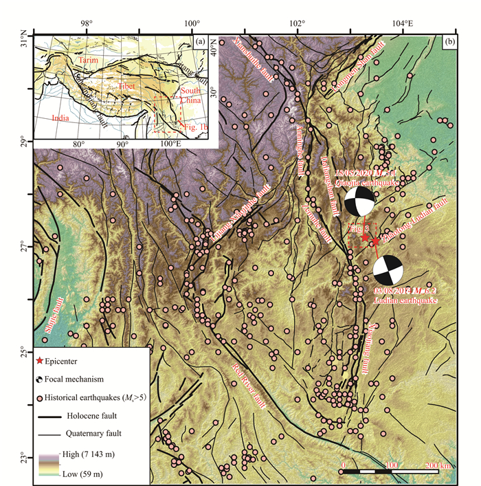
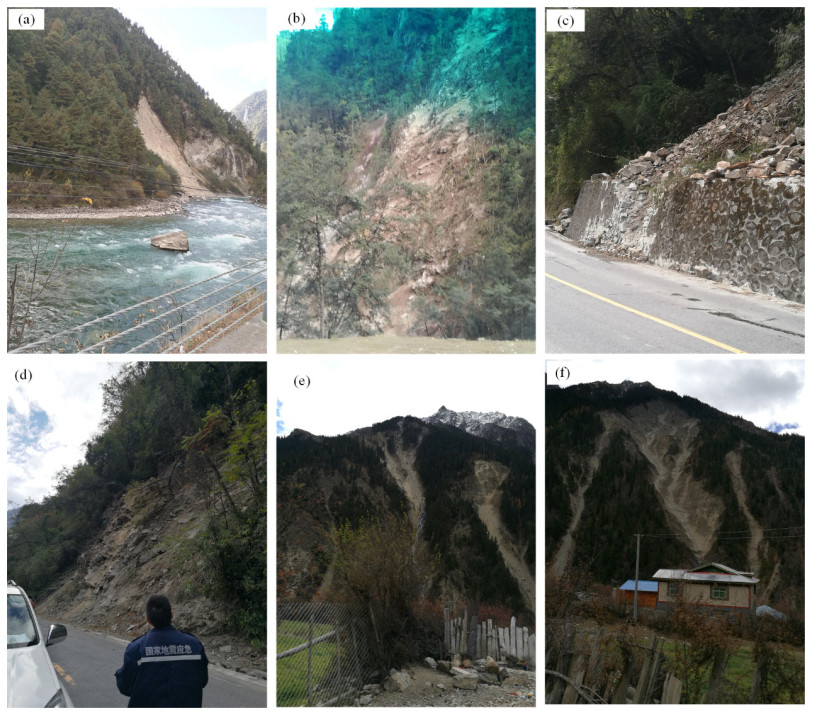
2021, 32(5): 1250-1261. doi: 10.1007/s12583-020-1373-z
Abstract:
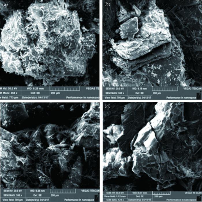
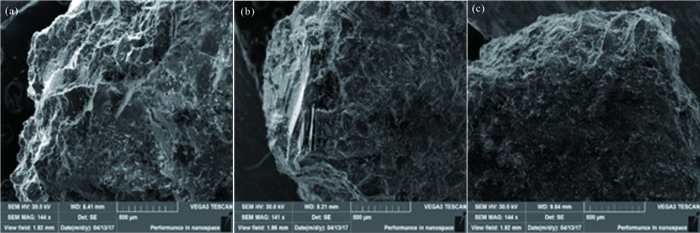
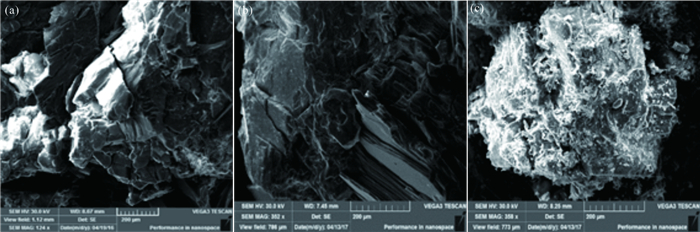
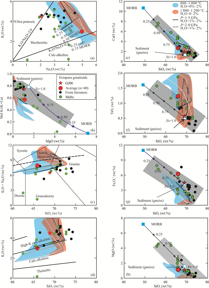
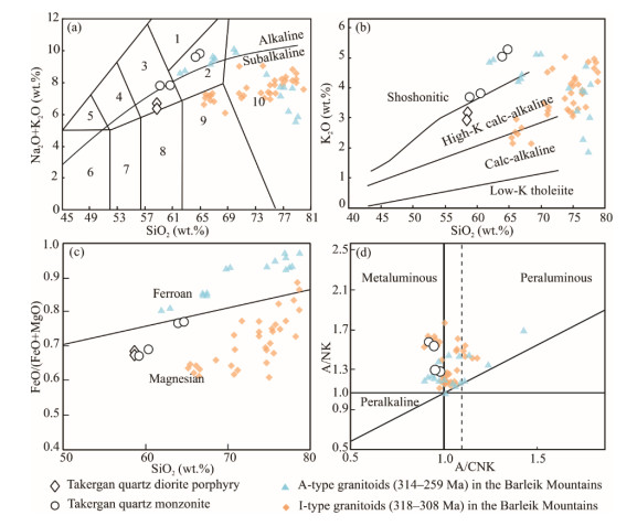
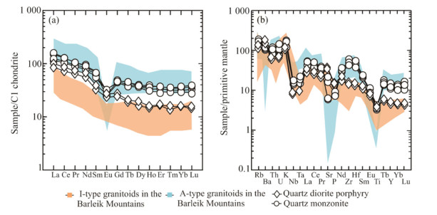
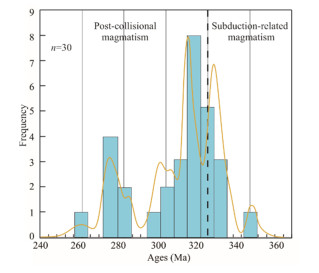
The Late Carboniferous and Early Permian igneous rocks are widely developed in the West Junggar, Xinjiang, which are considered to be related to the evolution of the Junggar-Balkhash Ocean. However, their tectonic settings have been controversial for a long time. With the aim of providing new evidence for the Late Paleozoic tectonic evolution of the West Junggar, we present petrology, zircon U-Pb chronology, whole-rock major and trace elemental and Sr-Nd isotopic data, to discuss the petrogenesis and tectonic setting of Takergan pluton from the Barleik Mountains in the West Junggar. The Takergan pluton is mainly composed of quartz diorite porphyry and quartz monzonite. The quartz diorite porphyry has low SiO2 (57.76 wt.%-57.81 wt.%), high total alkali contents (Na2O+K2O=6.29 wt.%-6.56 wt.%), and high Mg# values (45-46), with a zircon U-Pb age of 304±5 Ma. The quartz monzonite shows relatively high SiO2 (58.71 wt.%-64.71 wt.%), total alkali contents (7.73 wt.%-9.70 wt.%), and Mg# values (34-47), with the A/CNK values of 0.91-0.98, which belongs to shoshonitic and metaluminous Ⅰ-type granite series. The quartz monzonite yields zircon U-Pb ages of 302±2 and 296±3 Ma, and is characterized by low initial Sr ratios of 0.703 97-0.704 09, high εNd(t) values of +6.8- +7.0, and young Nd model ages of 551-587 Ma. Both the quartz diorite porphyry and quartz monzonite are enriched in light rare earth elements and Rb, Th, U, K, and depleted in Nb, Ta, Ti, with different degrees of negative Eu anomalies. These features indicate that the Takergan pluton was most likely formed in a post-collisional setting by partial melting of a depleted mantle source that had been metasomatized by subduction-related fluids, with significant fractional crystallization and slightly contaminated by crustal materials. Combined with the widespread distribution of the coeval stitching plutons, the occurrences of terrestrial Late Carboniferous to Permian volcano-sedimentary formations, and the absence of subduction-related rocks later than Early Carboniferous, it is believed that the Junggar-Balkhash Ocean was closed at about 320 Ma, and the central West Junggar has transformed to a post-collisional environment during the Late Carboniferous and Early Permian.
Maturity Assessment of the Lower Cambrian and Sinian Shales Using Multiple Technical Approaches
Wei Yang, Sheng He, Gangyi Zhai, Ze Tao, Xiaoqing Yuan, Sile Wei
2021, 32(5): 1262-1277. doi: 10.1007/s12583-020-1329-3
Abstract:
The Lower Cambrian Niutitang and Sinian Doushantuo shales are the most important and widespread source rocks and target layers in South China. Reliable data of the thermal maturity of organic matter (OM) is widely used to assess hydrocarbon generation and is a key property used in determining the viability and hydrocarbon potential of these new shales. Nevertheless, traditional thermal maturity indicators are no longer suited to the vitrinite-lack marine shales. This study aims to combine high throughput Raman and infrared spectroscopy analysis to confirm and validate the thermal maturity in comparison with the bitumen reflectance (Rb). Raman parameters such as the differences between the positions of the two bands (VG-VD) are strong parameters for calculating the thermal maturity in a large vitrinite reflectance (Ro) ranging from 1.60% to 3.80%. The infrared spectroscopy analysis indicates that the aromatic C=C bands and CH2/CH3 aliphatic groups both are closely correlated with thermal maturity. The calculated Ro results from Raman and infrared spectroscopy are in strong coincidence with the Rb. The relationships between Rb and pore volumes/surface areas (calculated from N2 adsorption) indicate that the sample with Rb of 3.40% has the lowest pore volumes and surface areas. Focused ion beam scanning electron microscopy (FIB-SEM) observations of OM pores indicate that Ro of approximately 3.60% may be an upper limit for OM porosity development. Obviously, kerogen Raman and infrared spectroscopy can indicate methods for reducing the risk in assessing maturity with practical, low-cost accurate results. Exploration of shale gas in the high maturity (>3.40%-3.60%) region carries huge risks.
Ammonium Impacts on Vibrations of Hydroxyl and Lattice of Phengite at High Temperature and High Pressure
Weihua Huang, Yan Yang, Zeming Qi, Wendi Liu, Zhongping Wang, Yan Liu, Qunke Xia
2021, 32(5): 1278-1286. doi: 10.1007/s12583-020-1113-4
Abstract:
Dehydration in hydrous phases of the downgoing slab controls water release processes in subduction zones. Interplay between volatiles in hydrous minerals has complicated the previous knowledge of their dehydration. Phengite is an essential mineral carrying both hydrogen and nitrogen to the deep Earth. To further understand the link between nitrogen and dehydration process of phengite at an atomic level, we here carry out high temperature and high pressure vibrational spectroscopic investigations on hydroxyl and lattice of ammonium-bearing and ammonium-free phengites. The results show that heating to 800 ℃ hardly influences hydroxyl bonding strength, whereas pressure induces strengthening of hydrogen bonding until 10 GPa. Moreover, hydrogen transits between the sites with increasing temperature and pressure. The lattice modes soften with increasing temperature and stiffen under compression. Ammonium has no effect on hydroxyl bonding strength, but hinders hydrogen transition at high temperatures and high pressures. Ammonium does not influence the lattice at high pressures either, but delays softening of the lattice at high temperatures. These data unveil behavior of hydroxyl and lattice in phengite at high temperature and high pressure, and also evaluate ammonium impacts, shedding new lights on dehydration processes of phengite during subduction.