Advanced Search

Indexed by SCI、CA、РЖ、PA、CSA、ZR、etc .

2015 Vol. 26, No. 6

Display Method:
CONTENTS
2015, 26(6): .
Abstract:
Special Issue on Near-Surface Geophysics
Foreword
Jianghai Xia
2015, 26(6): 775-775.
Abstract:
Cross-polarized GPR imaging of fracture flow channeling
Georgios P. Tsoflias, Christopher Perll, Matthew Baker, Matthew W. Becker
2015, 26(6): 776-784. doi: 10.1007/s12583-015-0612-1
Abstract:
Ground penetrating radar (GPR) can be used to image fractures and monitor fluid flow in the subsurface. Conventional GPR imaging uses single-polarization, co-polarized acquisition. We examine the use of cross-polarized GPR signals for imaging flow channeling in a discrete horizontal fracture. Numerical modeling (FDTD) demonstrates that when the fracture channel is oriented at an oblique angle to the survey line, depolarization of the GPR signal results in scattered energy along the cross-polarized components. When the channel is oriented parallel or orthogonal to the survey line, all scattered energy is captured by the co-polarized components and no signal is present in the cross-polarized orientation. Multipolarization, time-lapse 3D GPR field data were acquired at the Altona Flat Rock test site in New York State. The GPR surveys were conducted during background fresh fracture water conditions and during a natural gradient saline tracer test which was used to highlight flow channels along a sub-horizontal fracture. Amplitude analysis of the cross-polarized data reveals flow channeling that is in agreement with the co-polarized GPR images and with independent hydraulic tests. This investigation demonstrates that cross-polarized components of GPR signals can be used to enhance imaging of flow channels in fractured media.
Energy dissipation of P- and S-waves in fluid-saturated rocks: An overview focusing on hydraulically connected fractures
J. Germán Rubino, Beatriz Quintal, Tobias M. Müller, Luis Guarracino, Ralf Jänicke, Holger Steeb, Klaus Holliger
2015, 26(6): 785-790. doi: 10.1007/s12583-015-0613-0
Abstract:
An important characteristic of fractured rocks is their high seismic attenuation, which so far has been mainly attributed to wave-induced fluid flow (WIFF) between the fractures and the embedding matrix. The influence of fracture connectivity on seismic attenuation has, however, recently, only been investigated. Numerical compressibility and shear tests based on Biot's quasi-static poro-elastic equations illustrate that an important manifestation of WIFF arises in the presence of fracture connectivity. The corresponding energy loss, which can be significant for both P- and S-waves, is mainly due to fluid flow within the connected fractures and is sensitive to the permeabilities as well as the lengths and intersection angles of the fractures. Correspondingly, this phenomenon contains valuable information on the governing hydraulic properties of fractured rocks and hence should be accounted for whenever realistic seismic models of such media are needed.
Reverse-time prestack depth migration of GPR data from topography for amplitude reconstruction in complex environments
John H. Bradford
2015, 26(6): 791-798. doi: 10.1007/s12583-015-0596-x
Abstract:
With increased computational power, reverse-time prestack depth migration (RT-PSDM) has become a preferred imaging tool in seismic exploration, yet its use has remained relatively limited in ground-penetrating radar (GPR) applications. Complex topography alters the wavefield kinematics making for a challenging imaging problem. Model simulations show that topographic variation can substantially distort reflection amplitudes due to irregular wavefield spreading, attenuation anomalies due to irregular path lengths, and focusing and defocusing effects at the surface. The effects are magnified when the topographic variations are on the same order as the depth of investigation—a situation that is often encountered in GPR investigations. Here, I use a full wave-equation RT-PSDM algorithm to image GPR data in the presence of large topographic variability relative to the depth of investigation. The source and receiver wavefields are propagated directly from the topographic surface and this approach inherently corrects for irregular kinematics, spreading and attenuation. The results show that when GPR data are acquired in areas of extreme topography, RT-PSDM can accurately reconstruct reflector geometry as well as reflection amplitude.
Applications of the Hilbert-Huang transform for microtremor data analysis enhancement
Lanbo Liu, Robert Mehl, Weijun Wang, Qi-Fu Chen
2015, 26(6): 799-806. doi: 10.1007/s12583-015-0594-z
Abstract:
In this paper we discuss the use of the Hilbert-Huang transform (HHT) to enhance the time-frequency analysis of microtremor measurements. HHT is a powerful algorithm that combines the process of empirical mode decomposition (EMD) and the Hilbert transform to compose the Hilbert- Huang spectrum that contains the time-frequency-energy information of the recorded signals. HHT is an adaptive algorithm and does not require the signals to be linear or stationary. HHT is advantageous for analyzing microtremor data, since observed microtremors are commonly contaminated by nonstationary transient noises close to the recording instruments. This is especially true when microtremors are measured in an urban environment. In our data processing HHT was used to (1) eliminate the unwanted short-duration transient constituents from microtremor data and use only the coherent portion of the data to carry out the widely used horizontal to vertical spectral ratio (H/V) method; (2) identify and eliminate the continuous industrial noise in certain frequency band; and (3) enhance the H/V analysis by using the Hilbert-Huang spectrum (HHS). The efficacy of this proposed approach is demonstrated by the examples of applying it to microtremor data acquired in the metropolitan Beijing area.
Near-surface anisotropic structure characterization by Love wave inversion for assessing ground conditions in Urban Areas
Hao Xie, Lanbo Liu
2015, 26(6): 807-812. doi: 10.1007/s12583-015-0619-7
Abstract:
In many geophysical applications, neglecting of anisotropy is somehow an oversimplification. The mismatch between prediction based on isotropic theory and near-surface seismic observations indicates the need for the inclusion of medium anisotropy. In this paper, surface wave (Love wave) dispersion properties are used to estimate the anisotropic structure of the near-surface layered earth, which is modeled as media possess vertical transverse isotropy (VTI), a reasonable assumption for near-surface sedimentary layers. Our approach utilizes multi-mode surface waves to estimate both the velocity structure and the anisotropy structure. This approach consists of three parts. First, the dispersion analysis is used to extract dispersion curves from real data. Second, the forward modeling is carried out based on the dispersion equation of Love wave in a multi-layered VTI medium. Dispersion curves of multi-modes, which are the numerical solutions of the dispersion equation, are obtained by a graphic-based method. Finally, the very fast simulated annealing (VFSA) algorithm is used to invert velocity structure and anisotropy structure simultaneously. Our approach is verified by the synthetic dispersion curve generated by a VTI medium model. The estimation of shear wave velocity and anisotropy structure of surface wave data acquired at Rentschler Field, an urban center site on sediments in the Connecticut River valley reveals a simple structure of the sediment layer over a bedrock half space. The results are verified by other inversion results based on different data set obtained on the same site. The consistency of inversion results shows the feasibility and efficiency of the approach.
Spatial analysis of Fe deposits in Fujian Province, China: Implications for mineral exploration
Ziye Wang, Renguang Zuo, Zhenjie Zhang
2015, 26(6): 813-820. doi: 10.1007/s12583-015-0597-9
Abstract:
Spatial point pattern statistics, fractal analysis and Fry analysis in support of GIS were applied to explore the spatial distribution characteristics of mineral deposits and the spatial relationships between mineralization and geological features in Fujian Province (China). The results of Ripley's K(r) revealed a clustered distribution of Fe deposits in space with a fractal dimension of 1.38. Fry analysis showed that Fe deposits distributed mainly along a NNE-NE trend. Buffer analysis showed that most of the known Fe deposits developed within 4 km buffer zones of the NNE-NE-trending faults, Yanshanian intrusions, and Late Paleozoic marine sedimentary rocks and the carbonate formations (C–P Formation), indicating that they possibly control the spatial distribution of Fe mineralization. This is possibly because the NNE-NE-trending faults, Yanshanian intrusions, and C–P Formation provided pathways of fluids, energy and a part of metal, and zones of deposition for the Fe mineralization, respectively. The fractal relation of the number of Fe deposits occurring within the buffer zones of geological features was observed. The fractal dimension suggested that the significance of Yanshanian intrusions and C–P Formation are greater than that of NNE-NE-trending faults in controlling the formation of Fe mineralization. These findings are useful for better understanding the formation of the mineralization and provide significant information for further mineral exploration.
A goal-oriented adaptive finite element method for 3D resistivity modeling using dual-error weighting approach
Yixin Ye, Xiangyun Hu, Dong Xu
2015, 26(6): 821-826. doi: 10.1007/s12583-015-0598-8
Abstract:
A goal-oriented adaptive finite element (FE) method for solving 3D direct current (DC) resistivity modeling problem is presented. The model domain is subdivided into unstructured tetrahedral elements that allow for efficient local mesh refinement and flexible description of complex models. The elements that affect the solution at each receiver location are adaptively refined according to a goal-oriented posteriori error estimator using dual-error weighting approach. The FE method with adapting mesh can easily handle such structures at almost any level of complexity. The method is demonstrated on two synthetic resistivity models with analytical solutions and available results from integral equation method, so the errors can be quantified. The applicability of the numerical method is illustrated on a resistivity model with a topographic ridge. Numerical examples show that this method is flexible and accurate for geometrically complex situations.
An improved modeling of TDR signal propagation for measuring complex dielectric permittivity
Chih-Ping Lin, Shr-Hong Tang, Chun-Hung Lin, Chih-Chung Chung
2015, 26(6): 827-834. doi: 10.1007/s12583-015-0599-7
Abstract:
Time domain reflectometry (TDR) is a measurement technique based upon transmission line theory. The solutions of transmission line equations are reformulated in terms of independent physical properties, instead of coupled per-unit-length circuit parameters. The complete TDR response is effectively modeled by a non-uniform transmission line using the non-recursive ABCD matrix approach. Approaches to calibrate line parameters and perform TDR measurements based upon such model are introduced with an example on dielectric spectroscopy. TDR modeling in terms of decoupled physical parameters and non-recursive algorithm allows more convenient calibration of line parameters and facilitates interpretation of TDR measurements.
Iron biomineralization controls on geophysical signatures of hydrocarbon contaminated sediments
Estella A. Atekwana, Gamal Z. Abdel Aal
2015, 26(6): 835-843. doi: 10.1007/s12583-015-0611-2
Abstract:
The interpretation of geophysical data from mature hydrocarbon contaminated sites has relied on a conductive plume model where the conductivity of the subsurface contaminant volume is the result of microbial mediated changes in pore fluid chemistry. This conductive anomalous region is characterized by high total dissolved solids and occurs within the water table fluctuation zone where microbial activity is the maximum. Here we update this conductive plume model by providing new insights from recent laboratory investigations and geophysical data from hydrocarbon contaminated sites suggesting the unrecognized role of the impact that microbial-mediated metallic mineral precipitates have on geophysical signatures. We show that microbial redox processes (e.g., iron and sulfate reduction) during the biodegradation process involve mineralogical transformations and the precipitation of new minerals (e.g., magnetite, and pyrite) that can impact the electrical and magnetic properties of contaminated sediments. We provide examples from laboratory experiments and field studies and suggest that knowledge of the dominant redox processes occurring at hydrocarbon contaminated sites and the mineral phases formed is critical for a more robust interpretation of geophysical data associated with microbial-mediated changes at hydrocarbon contaminated sites. We also show that integration of both magnetic and electrical techniques may help reduce ambiguity in data interpretation.
Quantitative multi-layer electromagnetic induction inversion and full-waveform inversion of crosshole ground penetrating radar data
Jan van der Kruk, Nils Gueting, Anja Klotzsche, Guowei He, Sebastian Rudolph, Christian von Hebel, Xi Yang, Lutz Weihermüller, Achim Mester, Harry Vereecken
2015, 26(6): 844-850. doi: 10.1007/s12583-015-0610-3
Abstract:
Due to the recent system developments for the electromagnetic characterization of the subsurface, fast and easy acquisition is made feasible due to the fast measurement speed, easy coupling with GPS systems, and the availability of multi-channel electromagnetic induction (EMI) and ground penetrating radar (GPR) systems. Moreover, the increasing computer power enables the use of accurate forward modeling programs in advanced inversion algorithms where no approximations are used and the full information content of the measured data can be exploited. Here, recent developments of large-scale quantitative EMI inversion and full-waveform GPR inversion are discussed that yield higher resolution of quantitative medium properties compared to conventional approaches. In both cases a detailed forward model is used in the inversion procedure that is based on Maxwell's equations. The multi-channel EMI data that have different sensing depths for the different source-receiver offset are calibrated using a short electrical resistivity tomography (ERT) calibration line which makes it possible to invert for electrical conductivity changes with depth over large areas. The crosshole GPR full-waveform inversion yields significant higher resolution of the permittivity and conductivity images compared to ray-based inversion results.
Near-surface correction on seismic and gravity data
S. Bychkov, I. Y. Mityunina
2015, 26(6): 851-857. doi: 10.1007/s12583-015-0546-7
Abstract:
It is important and urgent to work out better statics correction methods to facilitate seismic prospecting. This paper presents a new method of statics correction calculation based on development of a seismic-gravity model of the near surface. Gravity interpretation includes determination of the local component caused by the near surface effects and calculation of the near-surface rock density by solving the linear inverse gravity problem. To obtain the near-surface velocities, priori seismic data such as time fields of the first waves recorded in the initial part of common depth point (CDP) seismograms are used. An optimal near-surface model is retrieved on the basis of the successive solution of the inverse and forward seismic problems, correlating with the observed seismic data. Matching of seismic and gravity model of the near surface yields the maximum coefficient of correlation between the values of velocities and densities. At the end of the interactive iterative process we get values of the near-surface seismic wave velocities, used for statics evaluation, and values of gravity anomalies, calculated with a variable density of the interbedded layer. The applications of the proposed method at geophysical exploration of oil and gas confirm the possibility of calculation of statics correction using the gravimetric data by constructing a coherent seismic-gravity model of the near surface.
Near range radar and its application to near surface geophysics and disaster mitigation
Motoyuki Sato
2015, 26(6): 858-863. doi: 10.1007/s12583-015-0595-y
Abstract:
In this paper, we discuss about the near range radar applied to various environmental applications and disaster mitigation issues. Synthetic aperture radar (SAR) processing or migration is the key technology in near range radar imaging, which can be used in ground penetrating radar (GPR) and ground-based synthetic aperture radar (GB-SAR). We demonstrate some applications which include GPR for humanitarian demining, GPR for archaeological survey, GB-SAR for landslide monitoring and nondestructive inspection of wooden buildings. We also demonstrate a new array GPR system "Yakumo", which was used for archaeological survey for demonstration of advanced multi-static radar signal processing for better radar imaging.
Radial anisotropy in the crust beneath the northeastern Tibetan Plateau from ambient noise tomography
Jing Tan, Hongyi Li, Xinfu Li, Ming Zhou, Longbin Ouyang, Sanjian Sun, Dan Zheng
2015, 26(6): 864-871. doi: 10.1007/s12583-015-0543-x
Abstract:
Through analysis of Rayleigh wave and Love wave Green's functions estimated from ambient noise tomography, we obtain radial anisotropy and shear wave velocity structure beneath the northeastern Tibetan Plateau. With two hundred and twenty three broadband seismic stations deployed by China Earthquake Administration, a collaborative seismic experiment of northern Tibet (ACSENT) experiment and northeastern Tibet seismic (NETS) experiment provide the unprecedented opportunity to resolve the spatial distribution of the radial anisotropy within the crust of the northeastern Tibetan Plateau. Discrepancies between Love (sh) and Rayleigh (sv) wave velocities show complex anisotropic patterns associated with the dynamic processes of the collision between the Indian and Eurasian plates: (1) In the upper crust, Vsv > Vsh anisotropy is dominant throughout the study area which probably reflects fossil microcracks induced by the uplift, folding and erosion geodynamic processes; (2) in the middle crust, Vsh > Vsv observed beneath the Songpan-Ganzi terrane and the northwestern Qilian orogen correlates well with a mid-crustal low velocity zone (LVZ); (3) at depths deeper than 40 km, Vsh > Vsv is still found in the Songpan-Ganzi terrane. This anisotropy could be caused by the sub-horizontal alignment of anisotropic minerals that has followed the collision between India and Eurasia. However, the northwestern Qilian orogen is associated with Vsv > Vsh anisotropy which may be related to the vertically aligned seismic anisotropic minerals caused by the crustal thickening.
Ages, trace elements and Hf-isotopic compositions of zircons from claystones around the Permian-Triassic boundary in the Zunyi Section, South China: Implications for nature and tectonic setting of the volcanism
Qiuling Gao, Zhong-Qiang Chen, Ning Zhang, William L. Griffin, Wenchen Xia, Guoqing Wang, Tengfei Jiang, Xuefei Xia, Suzanne Y. O'Reilly
2015, 26(6): 872-882. doi: 10.1007/s12583-015-0589-9
Abstract:
A growing body of evidence shows that volcanism near the Permian-Triassic boundary (PTB) may be crucial in triggering the Permian–Triassic (P–Tr) mass extinction. Thus, the ash beds near the PTB in South China may carry information on this event. Three volcanic ash layers, altered to clay, outcropped in the PTB beds in Zunyi Section, Guizhou Province, Southwest China. The U-Pb ages, trace elements, and Hf-isotope compositions of zircon grains from these three ash beds were analyzed using LA-ICPMS and LA-MC-ICPMS. The zircons are mainly magmatic in origin (241-279 Ma) except for two inherited/xenocrystic zircons (939 and 2 325 Ma). The ages of these magmatic zircons indicate three episodes of magmatism which occurred around the Middle- Late Permian boundary (~261.5 Ma, MLPB), the Wuchiapingian-Changhsingian boundary (~254.5 Ma, WCB), and the PTB (~250.5 Ma), respectively. The first two episodes of magmatism near the MLPB and WCB may be attributed to magmatic inheritance or re-deposition. All magmatic zircons share similar trace-element and Hf-isotope compositions. They have Y, Hf, Th and U contents and Nb/Ta ratios are typical of zircons from silicic calc-alkaline magmas. These zircons also exhibit enriched Hf-isotope compositions with εHf(t) values of -11.4 to +0.2, which suggests that the three magmatic episodes involved melting of the continental crust. The more enriched Hf-isotope composition (εHf(t)=-11.4- -4.8) of Bed ZY13 (~250.5 Ma) implies more input of ancient crustal material in the magma. Integration of the Hf-isotope and trace-element compositions of magmatic zircons suggest that these three episodes of magmatism may take place along the convergent continent margin in or near southwestern South China as a result of the closure of the Palaeo-Tethys Ocean.
Spurious thermoluminescence characteristics of the Ediacaran Doushantuo Formation (ca. 635–551 Ma) and its implications for marine dissolved organic carbon reservoir
Haiyang Wang, Chao Li, Chaoyong Hu, Shucheng Xie
2015, 26(6): 883-892. doi: 10.1007/s12583-015-0650-3
Abstract:
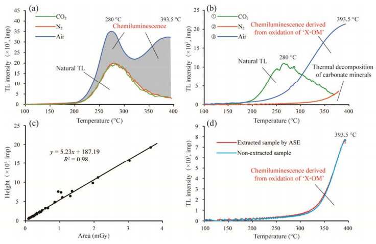
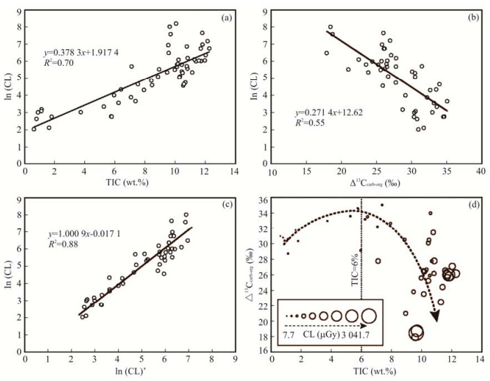
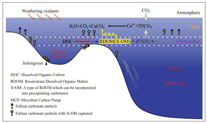
The Ediacaran Doushantuo Formation (ca. 635–551 Ma) deposited immediately after the last Neoproterozoic glaciations and recorded the most prominent negative excursions of carbonate carbon isotopic composition (δ13Ccarb). These excursions have been interpreted as a result of widespread remineralization of a large dissolved organic carbon (DOC) reservoir in the Ediacaran deep oceans. However, there is no direct evidence so far found in rocks for the proposed DOC reservoir, which devalues such an interpretation. Here, we conducted a detailed study on the glow-curves characteristics and signal origins of spurious thermoluminescence (TL) of the Doushantuo Formation at Jiulongwan in Yangtze Gorges area, South China, through sequential tests under CO2, N2 and air. Spurious TL intensities for test samples before and after removing soluble organic matter via accelerated solvent extraction (ASE) are nearly identical. Further, significant positive correlation between the spurious TL intensity and total inorganic carbon (TIC) content (R2=0.7) indicate that the Doushantuo spurious TL with the characteristic peak at 393.5 ℃ from the sequential test is chemiluminescence (CL) which is derived from the oxidation of a type of non-volatile organic matter strongly associated with carbonate mineral lattice (termed as "X-OM"). A most likely explanation is that the X-OM is a type of dissolved organic matter which co-precipitated with carbonate minerals into sediments in the Ediacaran Doushantuo Ocean. Furthermore, a significant exponential negative correlation (R2=0.55) is observed between the CL data and the isotopic difference between carbonate and coexisting bulk organic matter (i.e., Δ13Ccarb-org, a proxy for remineralization degree of DOC reservoir in proposed DOC hypothesis), suggesting that the X-OM was derived from the oxidation of the DOC reservoir in the Ediacaran Ocean. We thus propose that the X-OM and its CL detected in our study may have recorded the evolution of the possible DOC reservoir in the Ediacaran Doushantuo Ocean. If this is correct, the stratigraphic variations of the CL intensity in the Doushantuo Formation at Jiulongwan support the pulsed oxidation of the DOC reservoir in the Ediacaran Ocean. Our findings indicate that the CL derived from the oxidation of non-volatile organic matter which is strongly associated with carbonate mineral lattices in rocks may provide a feasible approach for probing the evolution of DOC reservoir in the ancient oceans, thus likely provide direct geological evidence for the development of oceanic DOC reservoir in geological times.
Mineral chemistry and geochemistry of peridotites from the Zedang and Luobusa ophiolites, Tibet: Implications for the evolution of the Neo-Tethys
Qiang Li, Bin Xia, Jianfeng Li, Lianze Xia, Qiangtai Huang, Zhongyu Xia
2015, 26(6): 893-910. doi: 10.1007/s12583-015-0544-9
Abstract:
We present a new dataset on platinum group elements (PGEs), whole-rock major and trace elements, and mineral chemistry for the peridotites from the Zedang and Luobusa ophiolite suites, Tibet, in an attempt to better constrain the petrogenesis of the Zedang and Luobusa ophiolites and the tectonic evolution of the Neo-Tethys. Plots of chondrite-normalized PGE, PGE vs. Mg#, and PGE vs. Al2O3 suggest that the lherzolite and harzburgite from Zedang and Luobusa have similar PGE characteristics. The Zedang and Luobusa peridotites display U-shaped REE patterns and are enriched in some incompatible elements, indicative of melt-rock interaction. The PGE characteristics may be attributed to partial melting and heterogeneous melt-rock interaction. Mineral chemistry and whole rock major and trace elements data suggest that lherzolite and harzburgite from Zedang and Luobusa have similar geochemical properties. On the spinel Mg# vs. Cr# plot, the composition of the Zedang and Luobusa peridotites is consistent with both abyssal and subduction-zone peridotites. This study indicates that the Zedang and Luobusa peridotites have a similar origin and evolution path: they could have originated from a normal mid-ocean ridge environment and got refertilization in a supra-subduction zone setting.
Timing of uranium mineralization and geological implications of Shazijiang Granite-Hosted uranium deposit in Guangxi, South China: New constraint from chemical U-Pb age
Jincheng Luo, Ruizhong Hu, Shaohua Shi
2015, 26(6): 911-919. doi: 10.1007/s12583-015-0542-y
Abstract:
Miaoershan (MES) uranium ore field is one of the most important uranium sources in China, hosts the largest Chanziping carbonaceous-siliceous-pelitic rock type uranium deposit in South China together with many other granite-hosted uranium deposits. The Shazijiang (SZJ) uranium deposit is one of the representative granite-hosted uranium deposits in the MES uranium ore field, situated in the Ziyuan, Guangxi Province, South China. Uranium mineralization in the SZJ deposit mainly occurs as uraninite with quartz and calcite veins that is spatially associated with mafic dykes in the region. The hydrothermal alteration includes silicification, carbonation and hematitization. New uraninite chemical U-Pb geochronology and petrographic evidences provide the timing constraints and new insights into the formation of the SZJ uranium deposit. The results show that the first stage of uranium mineralization formed at 97.5±4.0 Ma, whereas another stage of uranium mineralization occurred at 70.2±1.6 Ma. Two stages of uranium mineralization are fairly consistent with two episodic crustal extensions that occurred at ~100 and ~70 Ma throughout South China. This study indicates that there are two uranium mineralization events in SZJ uranium ore field controlled by mafic dyke, supporting that mafic dykes play an important topochemical role in uranium concentration and/or mobilization. Therefore, geochemical U-Pb age firstly reinforces that ore-forming age of the SZJ uranium deposit mainly yields at 97.5±4.0 and 70.2±1.6 Ma. Additionally, geochemical age method is particularly useful for interest samples which record information on multi-stage uranium mineralizations in South China.
Sr isotopes and REEs geochemistry of anhydrites from L vent black smoker chimney, East Pacific Rise 9°N–10°N
Huiqiang Yao, Huaiyang Zhou, Xiaotong Peng, Gaowen He
2015, 26(6): 920-928. doi: 10.1007/s12583-015-0545-8
Abstract:
High resolution sampling, for Sr isotope and REE analyses, was carried out along a transaction of L vent chimney collected from East Pacific Rise 9°N–10°N. Sr isotopes show these anhydrites are precipitated from a mixture between hydrothermal fluid and seawater. The calculated relative proportion of seawater and hydrothermal fluid shows that the mixing is heterogeneous on the transection of the L vent chimney. Anhydrites from the chimney show uniform chondrite-normalized REE pattern with enrichment of LREE and positive Eu anomaly. While normalized to the REE of end-member hydrothermal fluid, anhydrites also show uniform REE pattern but with negative Eu anomaly and enrichment of HREE. Combining previous studies on REEs of hydrothermal fluids from different hydrothermal systems and the hydrothermal fluid data from this region, we suggested that REE-anion complexing, rather than crystallography controlling, is the main factor that controls the REE partition behavior in the anhydrite during its precipitation from the mixture of hydrothermal fluid and seawater.