Advanced Search

Indexed by SCI、CA、РЖ、PA、CSA、ZR、etc .

2020 Vol. 31, No. 1

CONTENTS
CONTENTS
2020, 31(1): .
Abstract:
Paleontology
Ufadendron elongatum sp. nov., an Angaran Lycopsid from the Upper Permian of Inner Mongolia, China
Zhen Tang, Yi Zhang, Serge V. Naugolnykh, Changqing Zheng, Lu Shi, Tao Qin, Junhao Huang
2020, 31(1): 1-8. doi: 10.1007/s12583-019-1230-0
Abstract:
A new species Ufadendron elongatum sp. nov.,attributed to the family Tomiodendraceae Naugolnykh,is represented by two well-preserved stems in the collection under study. This new species was recently discovered from the Upper Permian Linxi Formation in the Jalaid locality,the Inner Mongolia Autonomous region,China. The genus Ufadendron is characterized as having the long fusiform leaf cushions,with small and rounded leaf scar containing a central point-like scar which is situated at the upper part of leaf cushion; the infrafoliar bladder of fusiform shape positioned in the middle part of leaf cushion; the wings and heel well-developed in the lateral parts and the lower part of leaf cushion,respectively. The new species is different from the type species U. ufaense (Naugolnykh 2014) collected from the Lower Permian of the Cis-Urals,western limits of Angaraland,in the elongated leaf cushion and in the well-pronounced heel. It should be noted,that a vascular bundle (conductive strand) occupied the middle part of the central point-like scar. So far,only 5 genera of Angaran elements among lycopsids have been discovered in the region geographically belonging to Angaran Realm (Phytogeoprovince) in China. The new species U. elongatum not only enlarges our knowledge on the taxonomy of Tomiodendraceae lycopsids,and also provides an opportunity to understand the difference between Angaran and Cathaysian floras in paleoclimatic context.
Conodont Biostratigraphy and Age of the Early Triassic Fish-Bearing-Nodule Levels from Nanjing and Jurong, Jiangsu Province, South China
Shuang Liu, Zuoyu Sun, Cheng Ji, Min Zhou, Dayong Jiang
2020, 31(1): 9-22. doi: 10.1007/s12583-019-1232-y
Abstract:
Fish-bearing-nodules are found in Early Triassic marine strata in many regions, including East Greenland, East Spitsbergen, Northwest Madagascar, Canada, Angola, and South China. A new Olenekian (Early Triassic) conodont biostratigraphic study for stratum that contains fish-bearing-nodule levels is conducted based on the Longtan (LT) Section of Nanjing City and the Qingshan (QS) Section of Jurong County, Jiangsu Province, South China. A total of 101 samples were collected at the two sections and three conodont zones were recognized:in ascending order, they are Scythogondolella (Sc.) milleri Zone, Novispathodus (Nv.) pingdingshanensis Zone, and Triassospathodus (Tr.) aff. homeri Zone. The Scythogondolella milleri Zone is globally recognized as the uppermost conodont zone of the Smithian and the base of the Novispathodus pingdingshanensis Zone was previously suggested as the marker of the Smithian-Spathian boundary in the Yangtze region. The fish-bearing-nodule levels of Nanjing and Jurong are within the conodont Scythogondolella milleri Zone, laterally correlated well with the upper part of the Novispathodus waageni Zone in Chaohu of Anhui Province that also contains fish-bearing-nodule levels. The conodont biostratigraphic correlation confirms the Early Triassic fish-bearing-nodule levels in the Lower Yangtze region are coeval, with an end-Smithian in age.
Petrology and Geochronology
Geochemistry and Geochronology of Diorite in Pengshan Area of Jiangxi Province: Implications for Magmatic Source and Tectonic Evolution of Jiangnan Orogenic Belt
Hongfeng Shi, Junpeng Wang, Yuan Yao, Jing Zhang, Song Jin, Yingxin Zhu, Kang Jiang, Xiaolong Tian, Deng Xiao, Wenbin Ning
2020, 31(1): 23-34. doi: 10.1007/s12583-020-0875-z
Abstract:
Magmatic activities associated with tectonic events play a significant role in understanding the evolution of an orogenic belt. The Jiangnan orogenic belt has been regarded as the collisional suture zone between the Yangtze Block and the Cathaysia Block. Although the magmatic activities during the period of intra-plate extension after the collision have been well studied in recent years,some remaining issues,including source nature and geodynamic mechanism,need to be further addressed. In this paper,based on a detailed field geological,petrological,geochemical and geochronological study,we focus our work on diorites in the Pengshan area located at the northwestern margin of the Jiangnan orogenic belt. The mineral assemblages are mainly composed of plagioclase (55 vol.%-65 vol.%) and hornblende (35 vol.%-45 vol.%). One diorite sample yields zircon 206Pb/238U mean age of 768±8 Ma (MSWD=0.29). The diorites have enriched large ion lithophile elements (Ba,K and Rb) and incompatible elements (Th and U),and are depleted in high field-strength elements including Ta,Ti and Nb. Diorites in this study have relatively high MgO content (6.56 wt.%-7.58 wt.%,7.07 wt.% on average) and Mg number values (65-67,65.8 on average). The diorites are metaluminous,high K calc-alkaline series rocks with high contents of K2O (1.59 wt.%-1.97 wt.%) and total alkali (Na2O+K2O=5.56 wt.%-6.05 wt.%). The Nd/Th ratio (4.34-5.27) is higher than that of crust-derived rocks and lower than mantle-derived rocks. The Rb/Sr ratio (0.19-0.22) is slightly lower than crust,but significantly higher than upper mantle. Based on the above geochemical and geochronological analyses,we suggest that the diorites in the Pengshan area were mainly derived from crustal materials with a small amount of mantle-originated materials involved,and possibly produced from an extensional tectonic setting after the collision between the Yangtze Block and Cathaysia Block.
Geochronological and Geochemical Constraints on the Petrogenesis of Early Paleoproterozoic (2.40-2.32 Ga) Nb-Enriched Mafic Rocks in Southwestern Yangtze Block and Its Tectonic Implications
Guichun Liu, Xin Qian, Jing Li, Jian-Wei Zi, Tianyu Zhao, Qinglai Feng, Guangyan Chen, Shaobin Hu
2020, 31(1): 35-52. doi: 10.1007/s12583-020-1260-7
Abstract:
Recent geological survey has identified the Early Paleoproterozoic meta-mafic intrusions in the southwestern Yangtze Block. We present geochronological,whole-rock geochemical and Nd isotopic data for these meta-mafic rocks to better address the tectonic evolution of the Yangtze Block during the Early Paleoproterozoic Period. Geochronological data show that the meta-mafic rocks have zircon ages of 2 395-2 316 Ma. They have high TiO2 contents of 1.40 wt.%-3.66 wt.% and Nb concentrations of 13.7 ppm-45.5 ppm,thus aregrouped as Nb-enriched mafic rocks. These mafic rocks are characterized by tholeiitic compositions with enrichment of LREEs and LILEs,and can be divided into two groups. Group 1 samples display E-MORB-like geochemical characteristics. Group 2 samples have positive εNd(t) values of 4.0-5.0. Geochemical data indicate that all meta-mafic rocks were likely derived from a depleted asthenospheric mantle. REE modeling indicates lower degree of partial melting for Group 2 samples (3%-10%) relative to Group 1 samples (15%-20%). Taking into account contemporaneous post-collisional granitoids in southwestern Yangtze Block,we propose that these meta-mafic rocks were formed in a post-collisional extension setting. These meta-mafic rocks can be compared with those in Africa,South America and Europe,and might be linked with the Arrowsmith orogenic belt.
Zircon U-Pb Ages and Magmatic History of the Kashan Plutons in the Central Urumieh-Dokhtar Magmatic Arc, Iran: Evidence for Neotethyan Subduction during Paleogene-Neogene
Tayebeh Khaksar, Nematollah Rashidnejad-Omran, Fukun Chen, Shu-Guang Song, Shuang-Qing Li, Majid Ghaderi
2020, 31(1): 53-68. doi: 10.1007/s12583-020-1258-1
Abstract:
The Kashan plutons are situated in the central part of Urumieh-Dokhtar magmatic arc recording subduction-related magmatism within the Alpine-Himalayan orogeny in Iran. These rocks consist of different calc-alkaline plutonic rocks including gabbro,gabbroic diorite,microdiorite,monzodiorite,tonalite,granodiorite,and granite. The plutons were emplaced into the Jurassic sedimentary units (Shemshak Formation) and the Eocene calc-alkaline volcanic and pyroclastic rocks. New U-Pb zircon ages show that the Kashan plutons formed during two main periods at 35.20±0.71 Ma in the Late Eocene (Priabonian) and at 18.90±0.84,19.26±0.83,19.30±1.2,and 17.3±1.8 Ma in the Early Miocene (Burdigalian). The reported events in the Kashan plutons imply the final phases of subduction-related magmatism before the collision which happened between the Arabian and Iranian plates in the Middle Miocene. The plutonic activity in the Kashan region occurred during the transition from Eocene subduction-related setting to Middle Miocene collisional setting.
SIMS U-Pb Zircon Geochronological and Carbon Isotope Chemostratigraphic Constraints on the Ediacaran-Cambrian Boundary Succession in the Three Gorges Area, South China
Taiyu Huang, Daizhao Chen, Yi Ding, Xiqiang Zhou, Gongjing Zhang
2020, 31(1): 69-78. doi: 10.1007/s12583-019-1233-x
Abstract:
The Ediacaran-Cambrian succession in South China records dramatic biological,oceanic and geochemical changes,but it is not well constrained geochronologically. This study reports a new SIMS U-Pb date of 543.4±3.5 Ma (MSWD=1.2) from a tuffaceous layer in the Zhoujiaao Section,and carbonate C-O isotopes in both Zhoujiaao and Sixi sections,Three Gorges area. This tuffaceous layer is present in the Upper Dengying Formation (i.e.,the Baimatuo Member) which is characterized by a stable δ13Ccarb plateau and the beginning of a negative δ13Ccarb shift near its upper boundary. In accordance with the existing biostratigraphic and chemostratigraphic data,this new date corroborates that the upper boundary of the Dengying Formation in South China is approximately equivalent to the Ediacaran-Cambrian boundary (ca. 541 Ma). This age also provides the minimum age of the last appearance of the Shibantan biota in the Three Gorges area,indicating that the terminal Ediacaran index fossils (e.g.,Cloudina,Sinotubulites) are not reliable stratigraphic markers for further subdivision of the uppermost Ediacaran.
Structural Geology
Deep Duplex Thrust in the Sangzhi-Shimen Tectonic Belt, in the West Hunan and Hubei Areas
Xuliang Zhang, Dengfa He
2020, 31(1): 79-90. doi: 10.1007/s12583-019-0873-1
Abstract:
Recent studies indicate that there is a large buried body developing in the Sangzhi-Shimen tectonic belt, which is between the Xuefeng intracontinental deformation system and the Xiangexi tectonic belt. In order to explore the tectonic evolution and main deformation-controlling factors of the buried body, we carried out a series of studies and built two new models based on the latest seismic data and fault-related fold theory. These new models show that the deformation of the buried body in the north segment of the study area is different from that in the middle-south segment. After further study, we found the main factors leading to these differences were:(1) the magnitude of the principal stress, (2) the range of tectonic movements, and (3) the morphology and depth of the basement detachment. Subsequently, with the physical simulation experiments, a 3D evolution model of the study area was built.
Precipitation of Calcite Veins in Serpentinized Harzburgite at Tianxiu Hydrothermal Field on Carlsberg Ridge (3.67°N), Northwest Indian Ocean: Implications for Fluid Circulation
Yang Chen, Xiqiu Han, Yejian Wang, Jianggu Lu
2020, 31(1): 91-101. doi: 10.1007/s12583-020-0876-y
Abstract:
Serpentinization and calcite precipitation of mantle peridotites exhumed along detachment faults at the slow-to ultraslow-spreading centers can provide important clues to the hydrothermal alteration processes. The Tianxiu hydrothermal field is a new-found active and ultramafic-hosted hydrothermal vent site along the Carlsberg Ridge, Northwest Indian Ocean. Two types of calcite veins are recognized in serpentinized harzburgite samples collected from the seafloor at the water depth of 3 500 m (3.67°N/63.83°E) and 400 m north of Tianxiu hydrothermal field. Calcite veins Ⅰ occur in the fractures that cut through mesh texture in the highly serpentinized harzburgite, while calcite veins Ⅱ precipitate within the mesh texture in the relatively weaker serpentinized harzburgite. Both veins show similar δ13CPDB (+0.54‰ and +0.58‰) but different δ18OPDB(-16.67‰ and +4.46‰) values, suggesting that they were derived from the same carbon source but precipitated at different temperatures. Taking the deep seawater temperature of 2℃ as the precipitation temperature of the calcite veins Ⅰ, the equilibrium δ18OV-SMOWof calcite-precipitating fluid was calculated to be 1.78‰, which is close to the average δ18OV-SMOW value (1.74‰) of vent fluid samples from the ultramafic-hosted hydrothermal systems worldwide. The formation temperature of calcite veins Ⅱ is inferred to be approximately 134℃, based on the calculated δ18OV-SMOW above. The temperature differences of calcite precipitation probably resulted from the fluid cooling conductively and mixing with seawater along the presumed fractures during slow upflow. The low-temperature calcite postdates the mesh texture, while the high-temperature calcite may precipitate under relatively low water/rock ratios, alkaline and reduced conditions among the mesh texture, which is revealed by the geochemical models. Therefore, it is suggested that they both have been influenced by hydrothermal fluids and the sampling site is near the discharge zone of hydrothermal circulation.
Nd-Hf Isotopic Decoupling of the Silurian-Devonian Granitoids in the Chinese Altai: A Consequence of Crustal Recycling of the Ordovician Accretionary Wedge?
Yanqiong Huang, Yingde Jiang, Yang Yu, Stephen Collett, Sheng Wang, Tan Shu, Kang Xu
2020, 31(1): 102-114. doi: 10.1007/s12583-019-1217-x
Abstract:
Voluminous Silurian-Devonian granitoids intruded a greywacke-dominated Ordovician accretionary wedge in the Chinese Altai. These granitoids are characterized by significant Nd-Hf isotopic decoupling, the underlying mechanism of which, so far, has been poorly understood. This issue is addressed in this study by the integration of our new and regional published geological and geochemical data. Geological studies indicated a close spatial relationship between the regional anatexis of the Ordovician wedge and the formation of the granitoids, which is characterized by a gradual textural evolution from the partial molten Ordovician wedge sedimentary rocks (the Habahe Group) to the granitoid bodies. Compositionally, these granitoids and the Ordovician Habahe Group rocks displayed close geochemical similarities, in the form of arc-like trace elemental signatures as well as comparable Nd isotopic characteristics. Combined with regional available data, we suggest that the Silurian-Devonian granitoids originated from the immature and chemically primitive Habahe Group rocks. Since Nd and Hf isotopic data for the Habahe Group rocks show significant Nd-Hf isotopic decoupling, we propose that the Silurian-Devonian granitoids inherited the Nd and Hf isotopic signatures from their sources, i.e., the Habahe Group rocks. In other words, the Nd-Hf decoupling in the Habahe Group rocks is the primary causative factor leading to the prevailing Nd-Hf isotopic decoupling of the Silurian-Devonian granitoids in the Chinese Altai.
Magnetic Fabric and Petrofabric of Amphibolites from the Namcha Barwa Complex, Eastern Himalaya
Wenjing Li, Haijun Xu, Junfeng Zhang
2020, 31(1): 115-125. doi: 10.1007/s12583-019-1021-7
Abstract:
The magnetic fabric and petrofabric are often used as tectonic indicators of geological and geodynamic processes that a rock has experienced such as growth, deformation and metamorphism. This study presents the low field anisotropy of magnetic susceptibility (AMS) and the crystallographic preferred orientation (CPO) of constituent minerals in amphibolites from the Namcha Barwa Complex in the eastern Himalayan Syntaxis, Tibet. The bulk magnetic susceptibility varies significantly from 7.3×10⁻⁴ to 3.314×10⁻² SI, with the Jelínek's anisotropy values (Pj) ranges from 1.094 to 1.487. The maximum susceptibility is approximately parallel to the lineation while the minimum susceptibility is subnormal to the foliation plane. Electron backscatter diffraction (EBSD) analyses show pronounced CPOs of amphibole in all samples, with a preferred alignment of the[001] axes along the lineation and the[100] axes spreading along a girdle normal to the lineation. Numerical simulations and comparison with laboratory measurements suggest that the magnetic anisotropy of amphibolite is largely controlled by the CPOs of amphibole. If present, the well oriented iron-titanium oxides such as ilmenite along rock foliation and lineation could increase the susceptibility and the anisotropy of a rock. Our results show a strong correlation between the magnetic anisotropy and the petrofabric of amphibolite, which could provide constraint for the interpretation of strong magnetic anomalies observed in the tectonic syntaxes of Tibet.
Environmental Geology and Geothermal
Zinc Isotope Characteristics in the Biogeochemical Cycle as Revealed by Analysis of Suspended Particulate Matter (SPM) in Aha Lake and Hongfeng Lake, Guizhou, China
Lili Liang, Cong-Qiang Liu, Xiangkun Zhu, Bryne T. Ngwenya, Zhongliang Wang, Liuting Song, Jin Li
2020, 31(1): 126-140. doi: 10.1007/s12583-017-0957-8
Abstract:
Zn isotope is a useful tool for tracing biogeochemical processes as zinc plays important roles in the biogeochemistry of natural systems. However, the Zn isotope composition in the lake ecosystems has not been well characterized. In order to resolve this problem, we investigate the Zn isotope compositions of suspended particulate matter (SPM) and biological samples collected from the Aha Lake and Hongfeng Lake, and their tributaries in summer and winter, aiming to explore the potential of this novel isotope system as a proxy for biogeochemical processes in aqueous environments. Concentration of dissolved Zn ranges from 0.65 to 5.06 μg/L and 0.74 to 12.04 μg/L for Aha Lake and Hongfeng Lake, respectively, while Zn (SPM) ranges from 0.18 to 0.70 mg/g and 0.24 to 0.75 mg/g for Aha Lake and Hongfeng Lake, respectively. The Zn isotope composition in SPM from Aha Lake and its main tributaries ranges from -0.18‰ to 0.27‰ and -0.17‰ to 0.46‰, respectively, and it varies from -0.29‰ to 0.26‰ and -0.04‰ to 0.48‰, respectively in Hongfeng Lake and its main tributaries, displaying a wider range in tributaries than lakes. These results imply that Zn isotope compositions are mainly affected by tributaries inputting into Aha Lake, while adsorption process by algae is the major factor for the Zn isotope composition in Hongfeng Lake, and ZnS precipitation leads to the light Zn isotope composition of SPM in summer. These data and results provide the basic information of the Zn isotope for the lake ecosystem, and promote the application of Zn isotope in biogeochemistry.
Petrogenesis, Tectonic Evolution and Geothermal Implications of Mesozoic Granites in the Huangshadong Geothermal Field, South China
Zhicai Xiao, Shuai Wang, Shihua Qi, Jian Kuang, Min Zhang, Feng Tian, Yongjie Han
2020, 31(1): 141-158. doi: 10.1007/s12583-019-1242-9
Abstract:
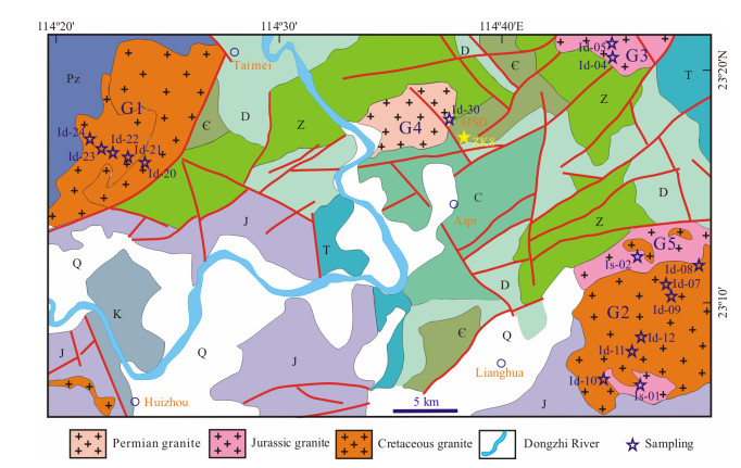
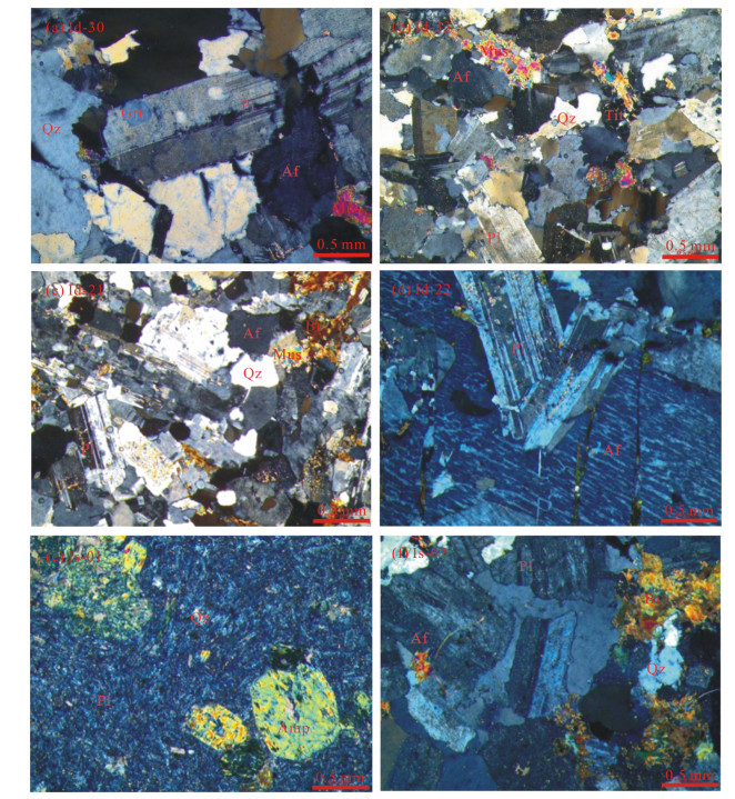
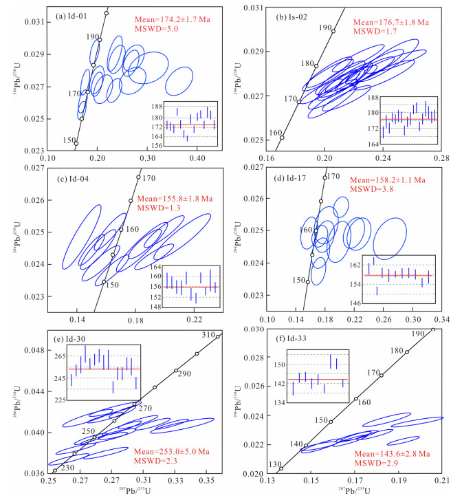
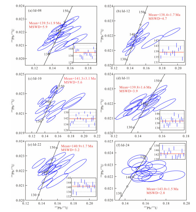
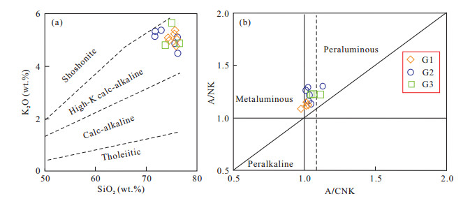
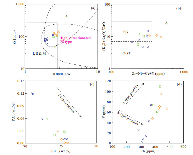
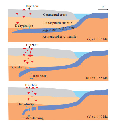
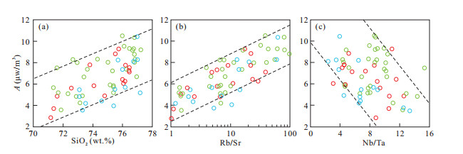
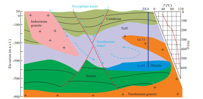
Mesozoic multi-stage tectono-magmatic events produced widely distributed granitoids in the South China Block. Huangshadong (HSD) is located in south-eastern South China Block, where closely spaced hot springs accompany outcrops of Mesozoic granites. New data on whole-rock geochemistry, zircon U-Pb geochronology, and zircon Lu-Hf isotopes are presented, to study the petrogenesis and tectonic evolution of the granites, and to explore the relationship between granites and geothermal anomalies. Zircon U-Pb isotopes display three periods of granites in the HSD area:Indosinian (ca. 253 Ma, G4) muscovite-bearing monzonitic granite, early Yanshanian (ca. 175-155 Ma, G5 and G3) monzonitic granite and granodiorite, and late Yanshanian (ca. 140 Ma, G1 and G2) biotite monzonitic granite. In petrogenetic type, granites of the three periods are Ⅰ-type granite. Among them, G1, G2, G3, and G4 are characterized by high fractionation, with high values of SiO2, alkalis, Ga/Al, and Rb/Sr, and depletion in Sr, Ba, Zr, Nb, Ti, REEs, with low (La/Yb)N, Nb/Ta, and Zr/Hf ratios and negative Eu anomalies. In terms of tectonic setting, 253 Ma G4 may be the product of partial melting of the ancient lower crust under post-orogenic extensional tectonics, as the closure of the Paleo-Tethys Ocean resulted in an intracontinental orogeny. At 175 Ma, the subduction of the Pacific Plate became the dominant tectonic system, and low-angle subduction of the Paleo-Pacific Plate facilitated partial melting of the subducted oceanic crust and basement to generate the hornblende-bearing Ⅰ-type granodiorite. As the dip angle of the subducting plate increased, the continental arc tectonic setting was transformed to back-arc extension, inducing intense partial melting of the lower crust at ca. 158 Ma and resulting in the most frequent granitic magmatic activity in the South China hinterland. When slab foundering occurred at ca. 140 Ma, underplating of mantle-derived magmas caused melting of the continental crust, generating extensive highly fractionated granites in HSD. Combining the granitic evolution of HSD and adjacent areas and radioactive heat production rates, it is suggested that highly fractionated granites are connected to the enrichments in U and Th with magma evolution. The high radioactive heat derived from the Yanshanian granites is an important part of the crustal heat, which contributes significantly to the terrestrial heat flow. Drilling ZK8 reveals deep, ca. 140 Ma granite, which implies the heat source of the geothermal anomalies is mainly the concealed Yanshanian granites, combining the granite distribution on the surface.
New Framework Based on Fusion Information from Multiple Landslide Data Sources and 3D Visualization
Fermín Villalpando, José Tuxpan, José Alfredo Ramos-Leal, Simón Carranco-Lozada
2020, 31(1): 159-168. doi: 10.1007/s12583-019-1243-8
Abstract:
Recent monitoring techniques employ multiple sources of information for the characterization of the phenomenon to be studied, being the coupling and adjustment of multi-source data one of the first challenges to consider and solve. The authors propose a new framework of the multi-source and mul-ti-temporal data-oriented fusion for the characterization of landslide events. The main objective is to generate 3D virtual models (in the form of dense point clouds) and feed them back with the characteristic of soil and subsoil information. The scheme consists of three main steps. The first one is on-site data collection (geological characterization, geophysical measurements, GPS measurements, and UAV/drone mapping). The second step is generation of a high-resolution 3D virtual model (~1-inch spatial resolution) from the frames acquired through the UAV using the structure of motion (SfM) processing; the developed virtual model is optimized with GPS measurements to minimize geolocation error and eliminate distortions. The last step is assembling of the acquired data in the field and densified point cloud considering the different nature of the data, re-escalating procedure and the information stacking layer.
Petroleum, Natural Gas Geology
Insights into Pore Structure and Fractal Characteristics of the Lower Cambrian Niutitang Formation Shale on the Yangtze Platform, South China
Zixuan Liu, Detian Yan, Xing Niu
2020, 31(1): 169-180. doi: 10.1007/s12583-020-1259-0
Abstract:
Shales from the Lower Cambrian Niutitang Formation of Yangtze Platform have been widely investigated due to its shale gas potential. To better illustrate the pore structure and fractal characteristics of shale, a series of experiments were conducted on outcrop samples from the Lower Cambrian Niutitang Formation on Yangtze Platform, including X-ray diffraction (XRD), field-emission scanning electron microscopy (FE-SEM) and low-temperature nitrogen adsorption. Frenkel-Halsey-Hill (FHH) model was adopted to calculate the fractal dimensions. Furthermore, the relationships between fractal dimensions and pore structure parameters and mineral composition are discussed. FE-SEM observation results show that interparticle pores are most developed in shale, followed by intraparticle pores. This study identified the fractal dimensions D1 (ranging from 2.558 0 to 2.710 2) and D2 (ranging from 2.541 5 to 2.765 2). The pore structure of the Niutitang Formation shale is primarily controlled by quartz and clay content. Fractal dimensions are able to characterize the pore structure complexity of Niutitang Formation shale because D1 and D2 correlate well with average pore diameter and quartz content.
New Insight into Factors Controlling Organic Matter Distribution in Lower Cambrian Source Rocks: A Study from the Qiongzhusi Formation in South China
Shucan Zheng, Qinglai Feng, Nicolas Tribovillard, Thomas Servais, Yan Zhang, Bo Gao
2020, 31(1): 181-194. doi: 10.1007/s12583-019-1240-y
Abstract:
Sedimentary organic matter (OM) is a major reservoir of organic carbon in the global carbon cycle. Despite many studies, there still exist many debates on the mechanism of OM accumulation and preservation in marine sediments. We present a new field study of a Lower Cambrian shallow marine shelf sequence in the northern edge of the Yangtze Plate, China. Our results show that palynological OM and biogenic silica (Bio-Si) could be used alongside more conventional redox and paleo-productivity proxies to study the distribution of OM in marine sediments. The qualitative and quantitative study of palynological OM provides more detailed information on the nature of sedimentary organic carbon, which can be helpful in the assessment of primary productivity and OM preservation. In addition, the presence of Bio-Si stimulates the physical preservation of OM. Further analysis indicates that an increase in Bio-Si can promote OM preservation. This case-study provides insight into the intertwined factors controlling OM accumulation in the Early Cambrian.
Hydrocarbon Generation, Migration, and Accumulation in the Eocene Niubao Formation in the Lunpola Basin, Tibet, China: Insights from Basin Modeling and Fluid Inclusion Analysis
Yiming Liu, Jiaren Ye, Qiang Cao, Baolin Yang, Zhongrong Liu
2020, 31(1): 195-206. doi: 10.1007/s12583-019-1211-3
Abstract:
The Eocene Niubao Formation is the primary research target of oil exploration in the Lunpola Basin. Crude oil was extracted from Well Z1 on the northern margin of the basin in 1993. In this study, an integrated evaluation of the source rock, geothermal, and maturity histories and the fluid inclusion and fluid potential distributions was performed to aid in predicting areas of hydrocarbon accumulation. Due to the abundance of organic matter, the kerogen types, maturity, and oil-sources correlate with the geochemical data. The middle submember of the second member of the Niubao Formation (E2n2-2) is the most favorable source rock based on the amount of oil produced from the E2n2-3and E2n3-1reservoirs. One- and two-dimensional basin modeling, using BasinMod software, shows that the E2n2-2source rock started to generate hydrocarbon at 35-30 Ma, reached a maturity of Ro=0.7% at 25-20 Ma, and at present, it has reached the peak oil generation stage with a thermal maturity of Ro=0.8% to less than Ro=1.0%. By using fiuid inclusion petrography, fiuorescence spectroscopy, and microthermometry, two major periods of oil charging have been revealed at 26.1-17.5 and 32.4-24.6 Ma. The oil accumulation modeling results, conducted by using the Trinity software, show a good fit of the oil shows in the wells and predict that the structural highs and lithologic transitions within the Jiangriaco and Paco sags are potential oil traps. KEY WORDS:Niubao Formation, Lunpola Basin, source rocks, basin modeling, fluid inclusions, hydrocarbon migration and accumulation, petroleum geology.
Remote Detection of Hydrocarbon Microseepage in a Loess Covered Area
Liang Zhao, Daming Wang, Shengbo Chen, Lin Li, Tianyu Zhang
2020, 31(1): 207-214. doi: 10.1007/s12583-019-1235-8
Abstract:
Hydrocarbon microseepage can result in related near-surface mineral alterations. In this study, we evaluated the potential of detecting these alterations with field measured and satellite acquired hyperspectral data. Fourteen soil samples and reflectance spectra were collected in the Xifeng Oilfield, a loess covered area. Soil samples were analyzed in the laboratory for calcite, dolomite, kaolinite, illite, and mixed-layer illite/smectite content, and we processed reflectance spectra for continuum removal to derive clay and carbonate mineral absorption depth (H). High correlation between absorption depth and mineral content was shown for clay and mineral carbonate with field measured spectra. Based on the result for the field spectra, we proposed and tested a fast index based on the absorption depth of clay and carbonate minerals with a hyperspectral image of the area. The detected hydrocarbon microseepage anomalies matched well with those shown in the geological map.
Environmental Risk Assessment for Exploration and Extraction Processes of Unconventional Hydrocarbon Deposits of Shale Gas and Tight Gas: Pomeranian and Carpathian Region Case Study as Largest Onshore Oilfields
Monika Wójcik, Wojciech Kostowski
2020, 31(1): 215-222. doi: 10.1007/s12583-020-1263-4
Abstract:
Shale gas and tight gas exploration and extraction processes create potential threats to the environment. In Poland, no comprehensive guidelines for environmental risk assessment have been prepared so far. This paper presents a proposal of environmental risk assessment methodology which can be used for corporate risk management procedures during exploration and extraction of unconventional hydrocarbons in Poland. The most frequent environmental threats that may occur during the exploration and exploitation of unconventional hydrocarbon deposits include degradation of soils through construction of drilling rigs and access roads, landforms change, local soil pollution caused by fuels, cleaning agents and materials used to prepare drilling fluids, rubble, cement, gravel, pollution of surface and underground water as a result of emergency discharges of sewage, infiltration of pollution from waste reservoirs, disturbance of hydrogeological equilibrium through significant water intake, noise and atmospheric pollution resulting from the combustion of fuels. To check the level of these threats' six exploration sites form Pomeranian and Carpathian region of Poland (3 wells of shale gas and 3 wells of tight gas) have been evaluated in detail, and the risk quantification has been made. Because of a local, short-term and reversible environment impact, the environmental risks for the exploration and extraction processes of unconventional hydrocarbons have been found to be medium or negligibly small. It is recommended that using the same methodology for other regions of Poland where we can find unconventional hydrocarbons and it can be enriched in dedicated application with spatial maps to give the investors a quick feedback on the potential environmental risks.