Advanced Search

Indexed by SCI、CA、РЖ、PA、CSA、ZR、etc .

2023 Vol. 34, No. 3

COVER
2023, 34(3)
Abstract:
CONTENTS
2023, 34(3)
Abstract:
Petrology and Geochemistry
Multiple Episodes of Zircon Growth during Anatectic Metamorphism of Metasedimentary Rocks in Collisional Orogens: Constraints from Felsic Granulites in the Bohemian Massif
Guang Yang, Ren-Xu Chen, Yong-Fei Zheng, Qiong-Xia Xia, Yong-Jie Yu, Kun Li, Zhaochu Hu, Bing Gong, Xiang-Ping Zha
2023, 34(3): 609-639. doi: 10.1007/s12583-021-1487-y
Abstract:

Zircon is a key accessary mineral for metamorphic geochronology and geochemical tracing,but it has been a challenge to interpret its complex chemical zoning and age record acquired during multiple episodes of anatectic metamorphism in collisional orogens. This is illustrated by a combined study of petrography,phase equilibrium modeling and metamorphic P-T-t determination for granulites from the Bohemian Massif in the Variscan Orogen. These rocks record multiple episodes of zircon growth during anatectic metamorphism. They started from the compressional heating for prograde metamorphism to high-pressure (HP) to ultrahigh-pressure (UHP) eclogite facies with low degrees of partial melting. Afterwards,they underwent a decompressional stage from UHP eclogite facies to HP granulite facies for dehydration melting. These were followed by a further decompressional stage either to kyanite granulite facies or to sillimanite granulite facies at ultrahigh-temperature (UHT) conditions. Episodes of zircon growth are linked to specific metamorphic conditions for peritectic reactions on the basis of zoning patterns,trace element signatures,index mineral inclusions in dated domains and textural relationships to coexisting minerals. The results indicate that relict zircon domains are preserved even at UHT granulite facies conditions. A few zircon domains in the kyanite granulite grew during the prograde to peak UHP metamorphism,possibly corresponding to consumption of biotite and plagioclase but growth of garnet. During the decompressional exhumation to the HP granulite-facies,relict or prograde zircon domains were mostly dissolved into anatectic melts produced by muscovite breakdown. Most zircon grains grew during this transition to the HP granulite-facies in the kyanite granulite and are chemically related to continuous growth of garnet,whereas abundant zircon grains grew subsequently at the UHT granulite facies in the sillimanite granulite and are chemically related to garnet breakdown reactions. Another peak of zircon growth occurred at the final crystallization of anatectic melts in the sillimanite granulite rather than in the kyanite granulite,and these zircon grains mostly show oscillatory zoning,low HREE + Y contents and significantly negative Eu anomalies. In terms of the inference for protolith nature,it appears that zircon in metasedimentary rocks can grow at a short timescale in different stages of anatectic metamorphism,and its dissolution and growth are mainly dictated by anatectic conditions and extent,the property of peritectic reactions,and the stability of Ti-rich minerals.

Metamorphic Evolution of Garnet Amphibolite from the Yaganbuyang Area in the South Altyn Orogen, West China: Insights from Phase Equilibria Modeling and Geochronology
Xin Li, Liang Liu, Xiaoying Liao, Yongsheng Gai, Tuo Ma, Guojian Geng, Tong Li
2023, 34(3): 640-657. doi: 10.1007/s12583-021-1439-6
Abstract:

Garnet amphibolite is one of the common metabasic rocks exposed in collisional orogenic belt, the metamorphic evolution of which is associated closely with orogenic processes. The Yaganbu-yang garnet amphibolites occur as blocks hosted by massive granitic gneiss, and consist mainly of hornblende, garnet, clinopyroxene, plagioclase, biotite, quartz with minor rutile/ilmenite and phengitic muscovite. These garnet amphibolites were interpreted to have experienced decompression-dominated evolution that can be divided into three generations (M1, M2, M3), based on the petrographic observations and phase equilibria modeling calculated by THERMOCALC. The assemblage of the first generation (M1) is inferred to possibly be dominated by garnet + omphacite + rutile + phengite + quartz, which is modeled to be roughly stable at P > 25 kbar and T > 800 ℃. The second generation (M2) is characterized by the local symplectites of clinopyroxene + plagioclase produced from omphacite, indicating a near-isothermal decompression from ~23.8 kbar/875 ℃ to ~10 kbar/852 ℃. The third generation (M3) is marked by the kelyphitic rims of plagioclase + hornblende around garnet and of hornblende + ilmenite around clinopyroxene, involving the late-stage retrogression from ~9.8 kbar/848 ℃ to ~5.8 kbar/645 ℃. Zircon U-Pb dating yielded one group metamorphic age of c. 500 Ma that is interpreted to represent the timing of the peak eclogite-facies metamorphism. A combination of petrography observation, phase modeling results and geochronology data suggests that the Yaganbuyang garnet amphibolites have once undergone eclogite-facies metamorphism by continental subduction rather than crustal thickening. Therefore, the Yaganbuyang area is an eastward extension part of the South Altyn HP-UHP metamorphic belt.

Multistage Formation of Neoarchean Potassic Meta-Granites and Evidence for Crustal Growth on the North Margin of the North China Craton
Xiaowei Zhang, Huafeng Zhang, Ying Tong
2023, 34(3): 658-673. doi: 10.1007/s12583-021-1419-x
Abstract:

The North China Craton (NCC) is one of the most complex cratons in the world. It underwent a series of tectonothermal events during the Neoarchean–Paleoproterozoic. The petrogenesis of potassic granitoids, the timing, and the style of Archean crustal growth are still debated. Systematic field and petrological stdudies on the potassic meta-granites from the Guyang-Chayouzhongqi region were carried out. New U-Pb ages, zircon Lu-Hf isotopic analyses, and whole-rock geochemical data were obtained. Two groups (~2.7 Ga and ~2.5 Ga) of potassic meta-granites were recognized. The ~2.7 Ga meta-granites are mainly A2-type, with variable εHf(t) values (-8.4 to +3.3) and Archean one stage model ages (TDM = ~3.0 Ga), indicating that their source was derived from ancient anatectic TTG-like granite and depleted mantle, which suggests that thin crust had formed in the Guyang-Chayouzhongqi region by ~3.0 Ga. Similar to the K-rich granites in the NCC, most of the ~2.5 Ga potassic meta-granites are typical of A1-type granite, and are enriched in Sm and Gd and depleted in Nb, Ta, P, and Ti. The ages and isotopic data indicate that the ~2.5 Ga meta-granites were generated from juvenile crustal sources with Neoarchean TTGs. The overall zircon U-Pb and Hf isotopic data furthermore suggested that the ~2.7 Ga event is the most important stage of magmatic accretion in the NCC, similar to other cratons. In contrast, reworking or metamorphic alteration was the main crustal process in the NCC at ~2.5 Ga.

Role of Magmatism and Related-Exsolved Fluids during Ta-Nb-Sn Concentration in the Central Eastern Desert of Egypt: Evidences from Mineral Chemistry and Fluid Inclusions
Mohamed Abd El Monsef, Mabrouk Sami, Fatma Toksoy-Köksal, Rainer Abart, Martin Ondrejka, Khaled M. Abdelfadil
2023, 34(3): 674-689. doi: 10.1007/s12583-022-1778-y
Abstract:

The rare metals of Abu Dabbab area in the Central Eastern Desert of Egypt have been investigated for their mineralogy and conditions of precipitation using combination of EMPA and fluid inclusions studies, in order to delineate the source, mechanism of formation and evolutionary model for these economic metals. The (Ta-Nb-Sn)-bearing minerals at the Abu Dabbab area include columbite group minerals (CGMs), wodginite and cassiterite. In both granitic intrusion and its enclosed quartz veins, most of zoned CGMs and cassiterite grains are commonly characterized by a well-developed two-stage texture. Hence, columbite-(Mn) (CGM-Ⅰ) represents the early formed phase of CGMs that is characterized by high Mn# values (0.64–0.92) with quite low Ta# values (0.13–0.49). It was invaded by Ta-rich phases including tantalite-(Mn) (CGM-Ⅱ; Ta# = 0.13–0.49) and wodginite, which contain high Ta2O5 and SnO2 (17.91 wt.%). In regard to cassiterite, there are distinct compositional differences between the early-phase cassiterite (Cst-Ⅰ) and the late-phase one (Cst-Ⅱ), where the latter is enriched in Ta2O5, Nb2O5 and FeO. The chemistry and textural criteria of the early stage CGM-Ⅰ and Cst-Ⅰ, all are indicative of magmatic origin. While, the latter CGM-Ⅱ, wodginite and Cst-Ⅱ were influenced by the late magmatic Ta-rich fluids. Fluid inclusions microthermometry shows criteria of phase separation represented by both boiling and fluid immiscibility. The initial fluid was supposed to be of magmatic origin (magmatic CH4), that was consequently influenced by fluid mixing/dilution with post-hydrothermal/meteoric water with respect to the decompression process during uplift. Isochore construction gave rise to an estimate P-T conditions (T = 330–370 ℃, P = 22–50 MPa). The fluid inclusions' microthermometry supports a transition between magmatic and late to post-hydrothermal activities in addition to surface-derived fluid (meteoric fluid?) in a part as main source for the polymetallic deposits.

Devonian–Carboniferous Pillow OIB-Type Basalts in the Youjiang Basin, SW China: Implications for the Eastern Extension of the Paleo-Tethys Branch Ocean
Jie Yang, Yuansheng Du, Hu Huang, Jianghai Yang, Hongwei Huang, Zhiqiang Huang
2023, 34(3): 690-705. doi: 10.1007/s12583-020-1098-z
Abstract:

Late Paleozoic pillow basalts are well preserved in the Youjiang Basin of SW China. In this study, we conducted geochemical and Sr-Nd isotopic study on the Late Devonian and Late Carboniferous basalts in Napo area, Youjiang Basin. The analyzed samples comprise moderate SiO2, TiO2, Mg#, and REE contents, with slightly positive or negative Eu anomalies, similar to the chemical nature of OIB (Oceanic island basalt). All basalts show low (143Nd/144Nd)i and (87Sr/86Sr)i values, close to EMI-type (Ⅰ-type Enriched Mantle) magma source. Late Carboniferous basalts display higher (87Sr/86Sr)i, Nb/Th, and lower εNd(t), Zr/Nb values than those of the Late Devonian basalts, implying progressively decreased enrichment components in the magma source processes. Such evolution trend reflects a continuous lithospheric thinning event, supporting a progressive rifting setting of the Youjiang Basin along the southwestern margin of the Yangtze Block in Late Paleozoic. Combined with regional geological background, the Youjiang Basin is viewed as a continental rift basin related to the opening of the Paleo-Tethys Ocean in Late Devonian and became a passive continental margin basin in Carboniferous. The Paleo-Tethys branch ocean probably extended further to the southern Youjiang Basin, likely corresponding to the Song Ma suture zone.

Plumbing System of Hunga Tonga Hunga Ha'apai Volcano
Román Alvarez, Miguel Camacho
2023, 34(3): 706-716. doi: 10.1007/s12583-022-1792-0
Abstract:

The Hunga Tonga Hunga Ha'apai submarine volcano has experienced repeated eruptions in the latest decades. The recent one, in January 2022, released an enormous amount of energy inducing global perturbations, as tsunamis and atmospheric waves. The structure of the volcano is poorly understood, especially its internal structure. Deep-seated magmatic connections are difficult to define or visualize. We use a high-resolution gravity data set obtained via satellite to calculate the Bouguer anomaly over its structure, to perform a preliminary exploration of its interior. Executing 3D gravity inversions, we find a complex plumbing system with various exhaust trajectories and multiple surface pockets of low-density material within the volcanic edifice; some appear to be associated with ring fractures. This is in line with the report of the 2009 eruption, described as beginning from multiple vents. We found no signs of a magma chamber within 6 km depth, although several volcanic conduits are identified from such depth to the surface. Density variations occur within a plumbing conduit or may vary from one conduit to another in the same volcano. These models yield quantitative estimates for areas of magma-water interaction, constituting a baseline to compare with structural changes to be induced in future eruptions.

Low Temperature Thermal History Reconstruction Based on Apatite Fission-Track Length Distribution and Apatite U-Th/He Age Using Low-T Thermo
Ruxin Ding
2023, 34(3): 717-725. doi: 10.1007/s12583-020-1071-x
Abstract:

Low temperature thermochronology plays a key role in the study of the tectonic evolution of the upper crust. History modeling of apatite fission-track requires the apparent age and the confined track-length distribution of spontaneous tracks. Obtaining length data does not require either thermal neutron irradiation or LA-ICP-MS measurements of the uranium content of the grains. This paper attempts to decouple the apatite fission-track age from the apatite fission-track length, but to combine the fission-track lengths with the respective apatite U-Th/He age to model the thermal history. The experiments were designed and conducted using a new Mathematica® modeling software "Low-T Thermo". Results of this modeling show that the thermal history modeling of apatite U-Th/He and fission-track ages can constrain the apatite fission-track length thermal history in the He partial retention zone and fission-track partial annealing zone, respectively. It implies that this combination of apatite fission-track length and apatite U-Th/He age has not been implemented before but is presented here as an alternative way of determining thermal histories without the addition of apatite fission-track age.

Clumped Isotope Analysis of Calcite and Dolomite Mixtures Using Selective Acid Extraction
Sen Li, Andrew Schauer, Alexis Licht, Jie Liang, Kate Huntington, Kangning Peng
2023, 34(3): 726-734. doi: 10.1007/s12583-022-1630-4
Abstract:

Acid extraction methods have been used in the last half century to selectively extract the CO2 produced from different carbonate minerals in mixed samples. However, these methods are often time-consuming and labor intensive. Their application to clumped isotope (Δ47) analysis has not been demonstrated. We propose here an acid extraction method with phosphoric acid for bulk stable and clumped isotope analysis that treats mixtures of calcite and dolomite the same regardless of the proportional composition. CO2 evolved from calcite is extracted by allowing a reaction with phosphoric acid to proceed for 10 min at 50 ℃. We then extract CO2 evolved from dolomite by rapid ramping the acid temperature from 50 to 90 ℃ and allowing the reaction to complete. The experimental results show that our method yields accurate calcite and dolomite Δ47 values from mixed samples under different proportional compositions. Our method also displays equal or higher accuracy for calcite δ13C and dolomite δ13C and δ18O values from mixtures when compared to previous studies. Our approach exhibits higher sample throughput than previous methods, is adequate for clumped isotopic analysis and simplifies the reaction progression from over 24 h to less than 2 h, while maintaining relatively high isotopic obtaining accuracy. It yet poorly resolves calcite δ18O values, as found with previous methods.

CorelKit: An Extensible CorelDraw VBA Program for Geoscience Drawing
Junwu Zhang, Xian Liang, Fangyue Wang, Huaikun Wang, Yu Fan, Te Ba, Xiangxi Meng
2023, 34(3): 735-757. doi: 10.1007/s12583-022-1772-4
Abstract:

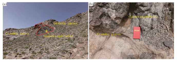
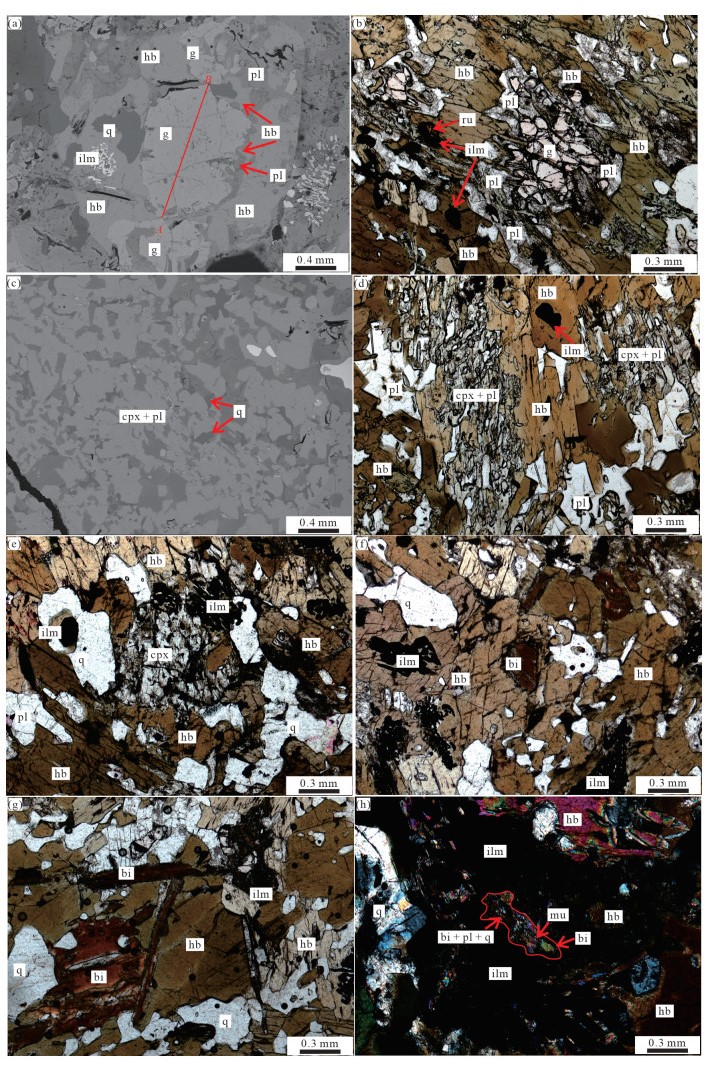
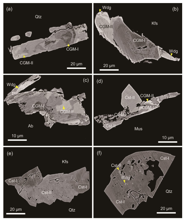
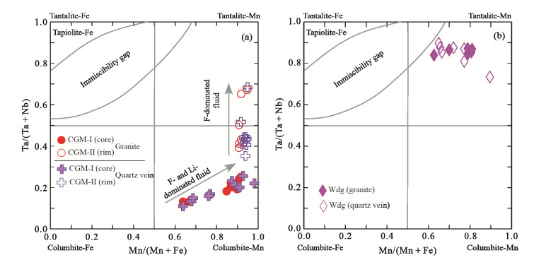
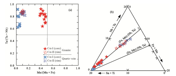
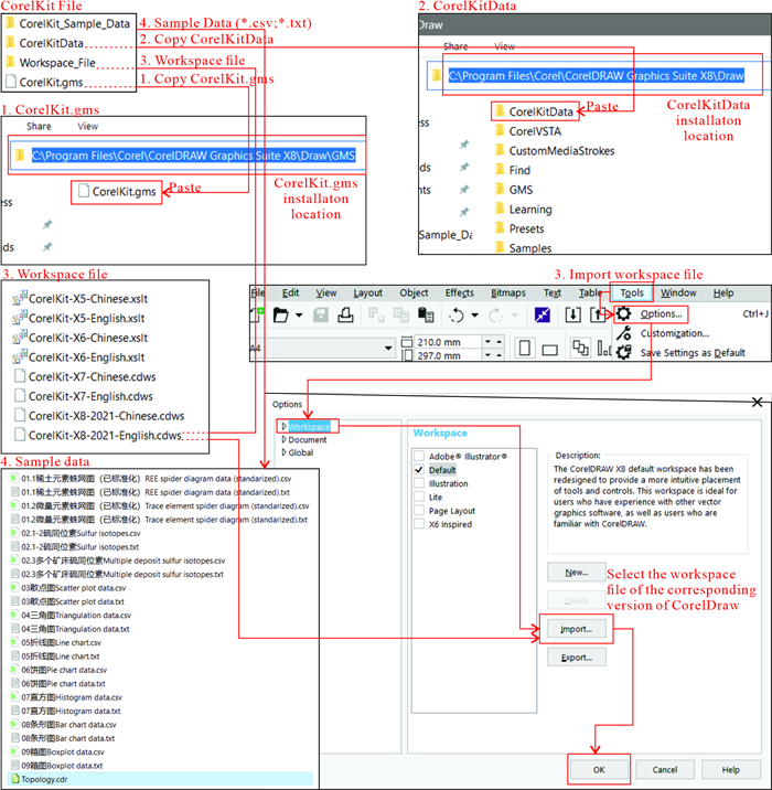
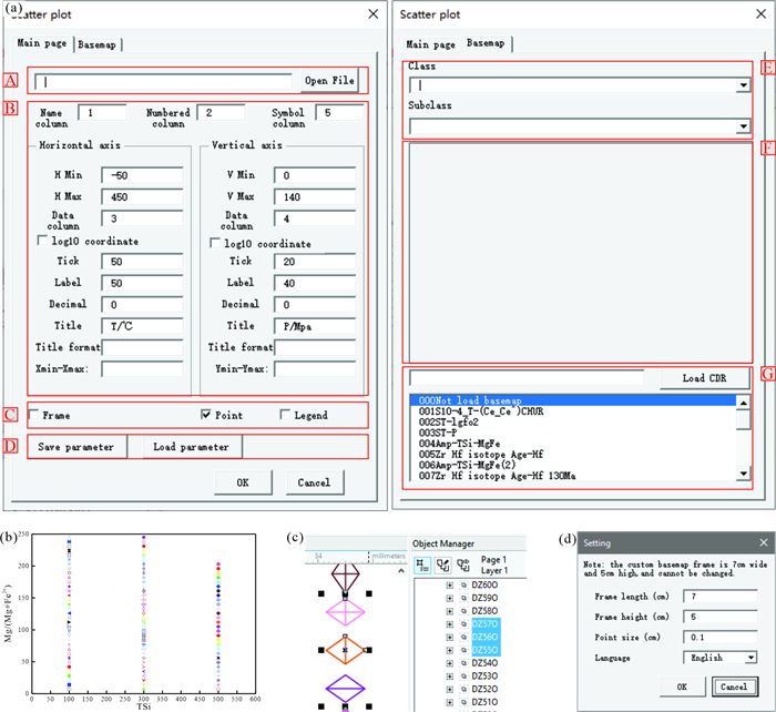
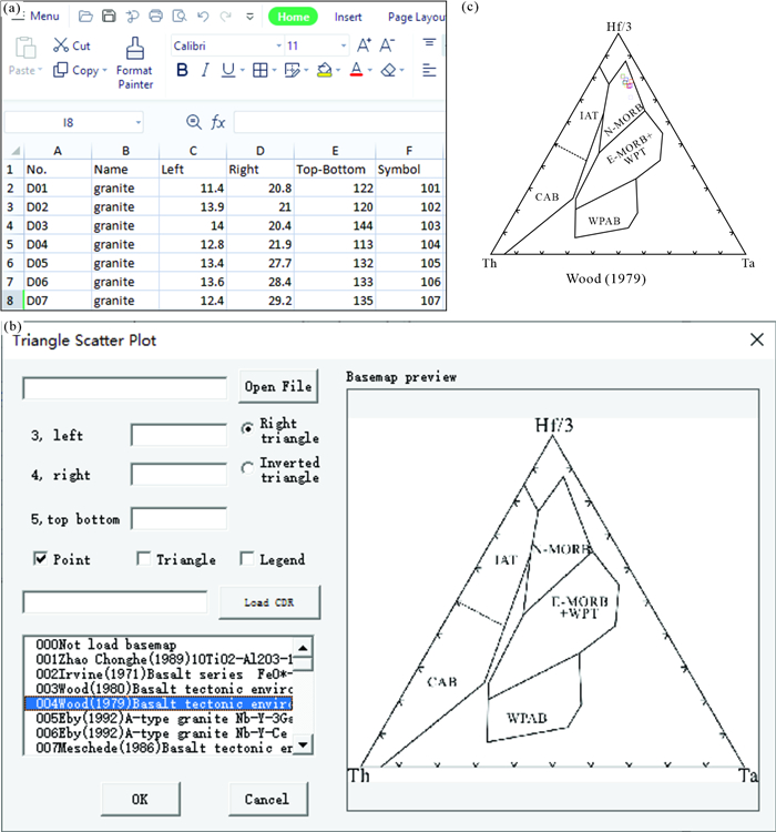
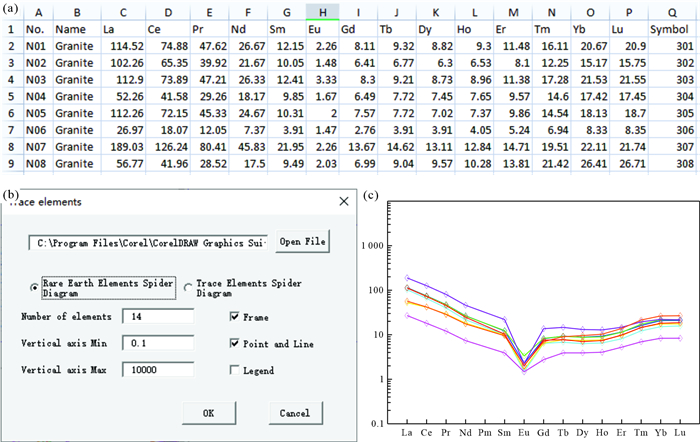
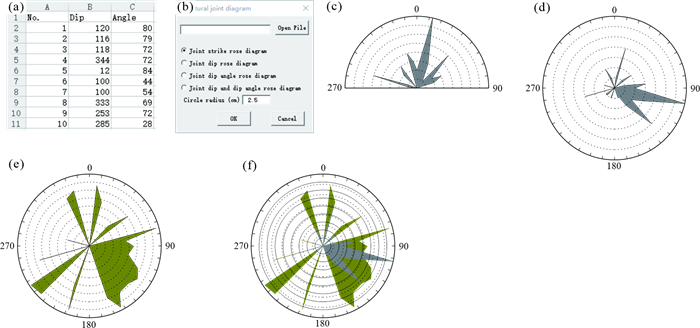
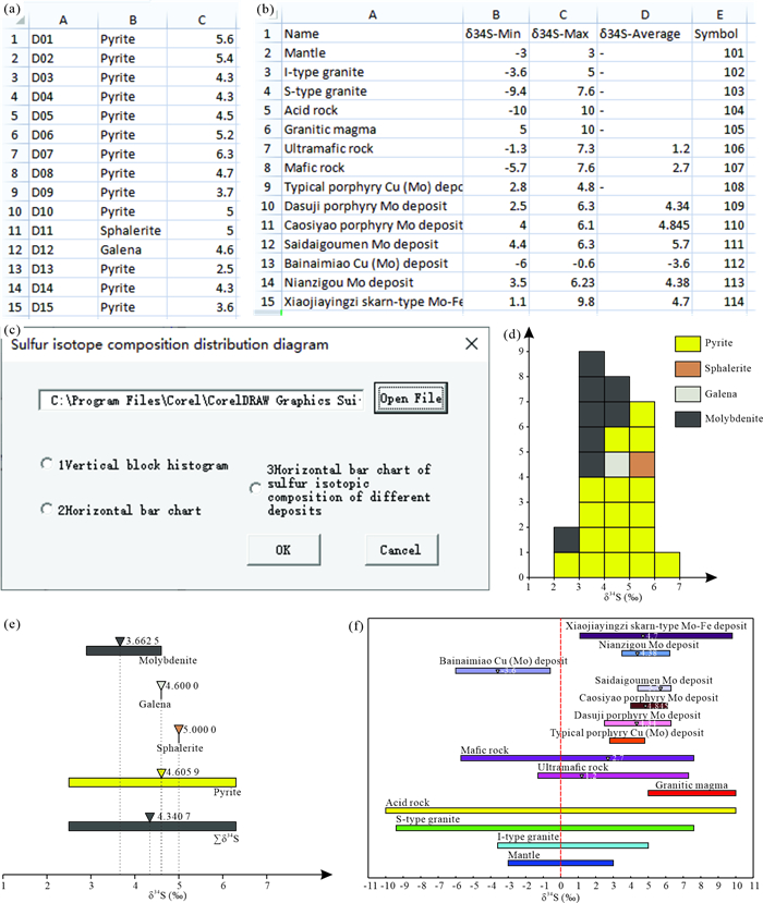
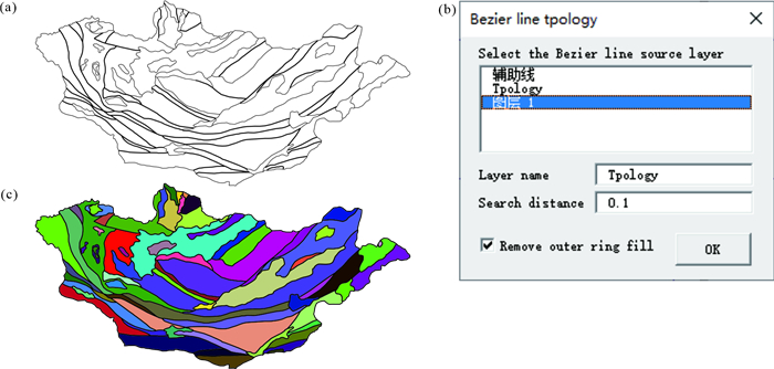
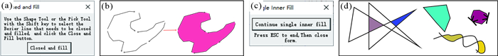
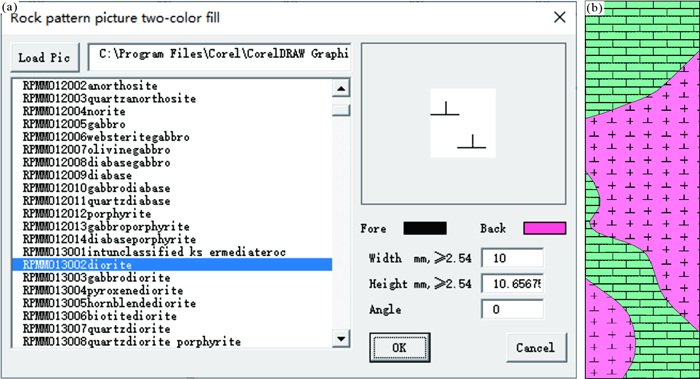
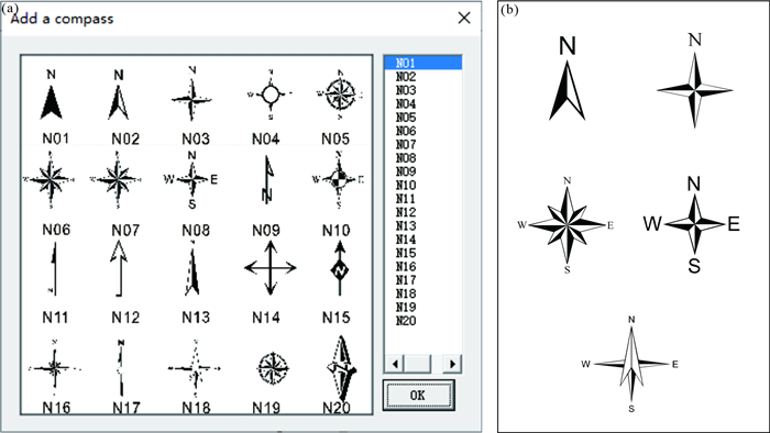
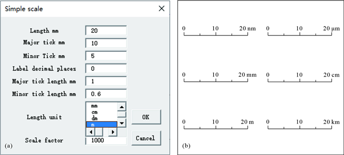
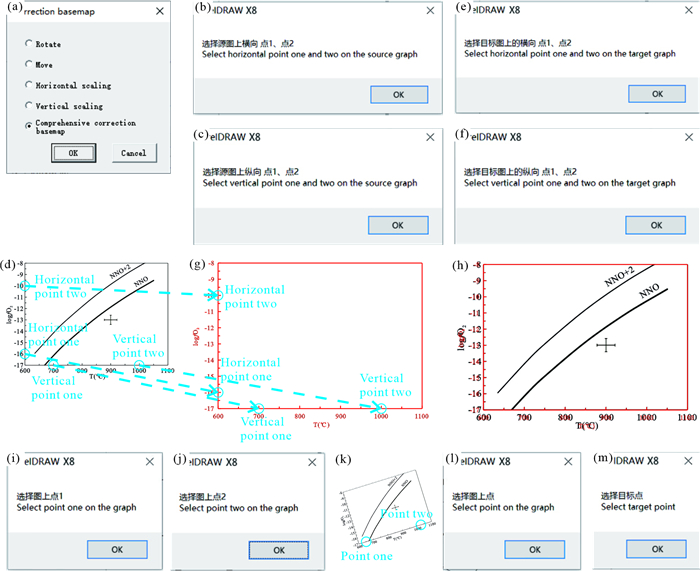
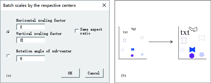
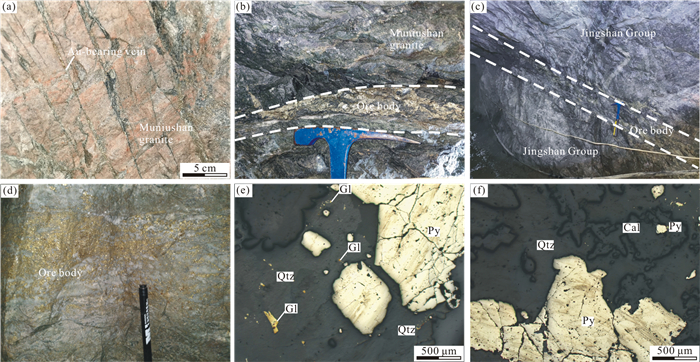
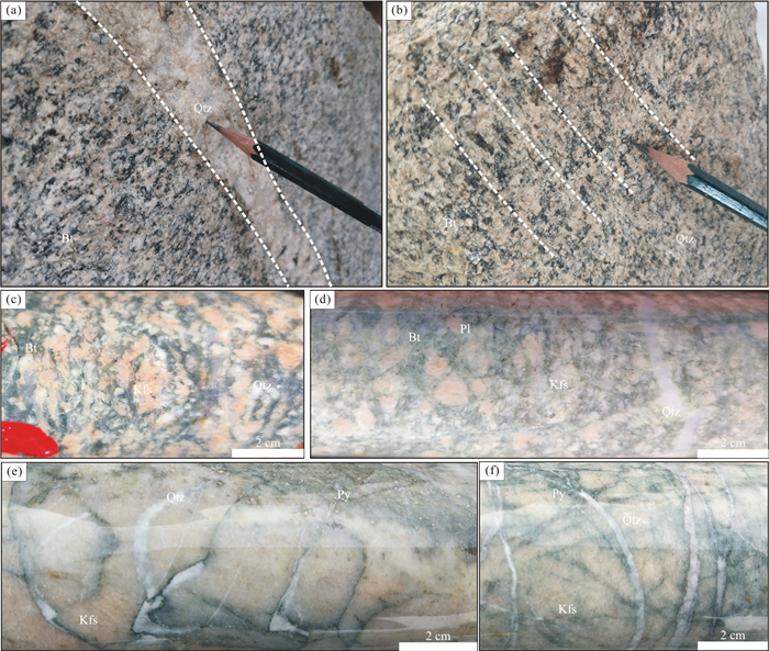
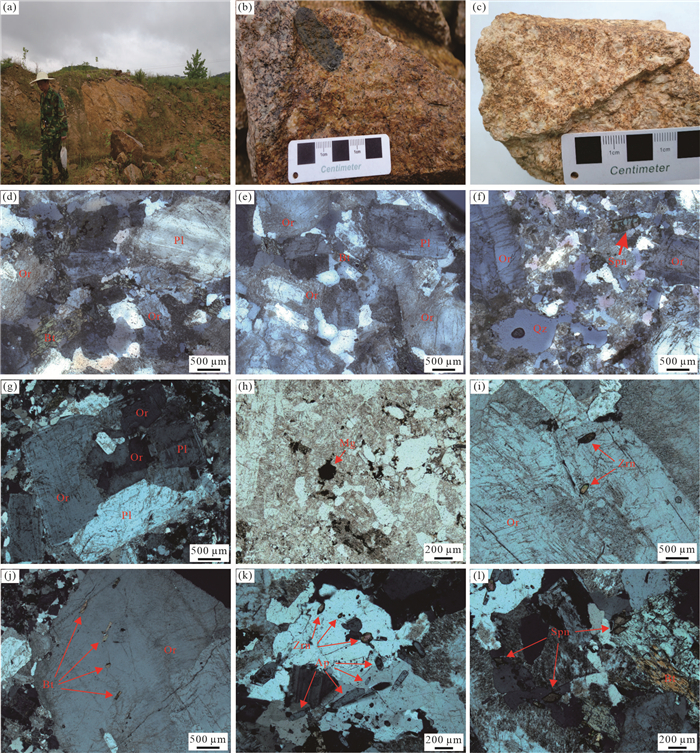
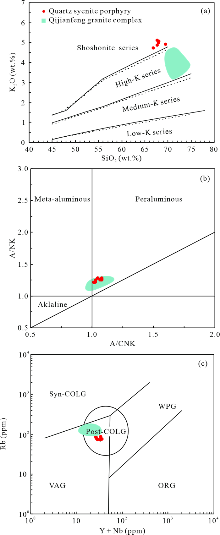
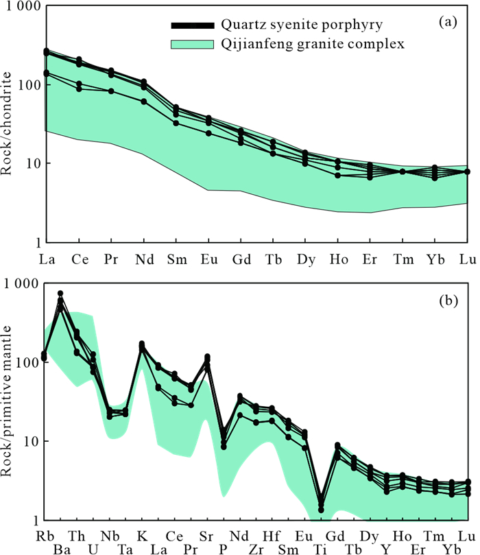
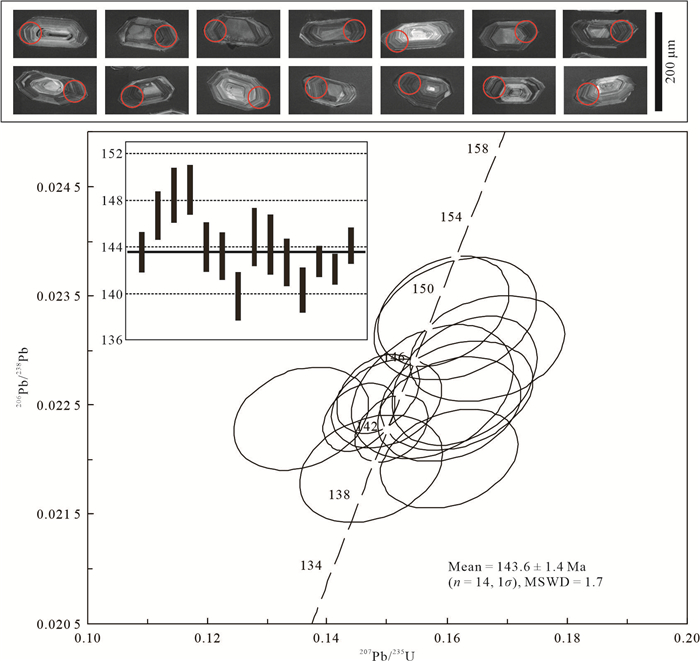
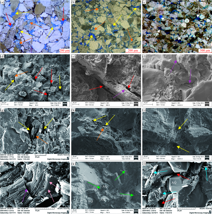
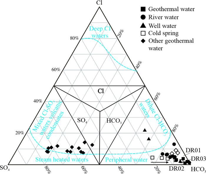
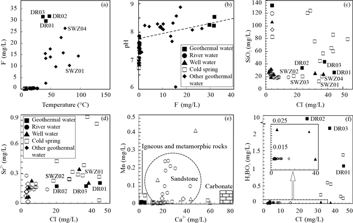
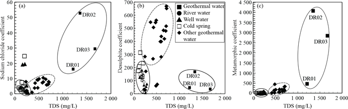
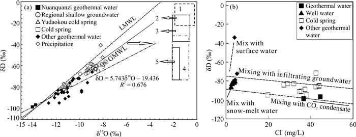
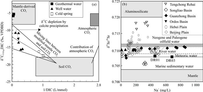
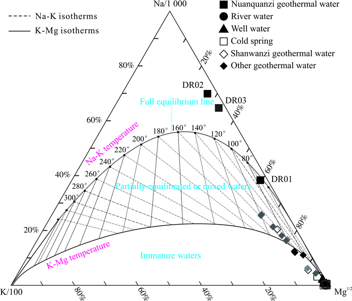
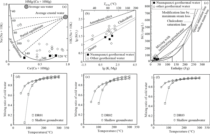
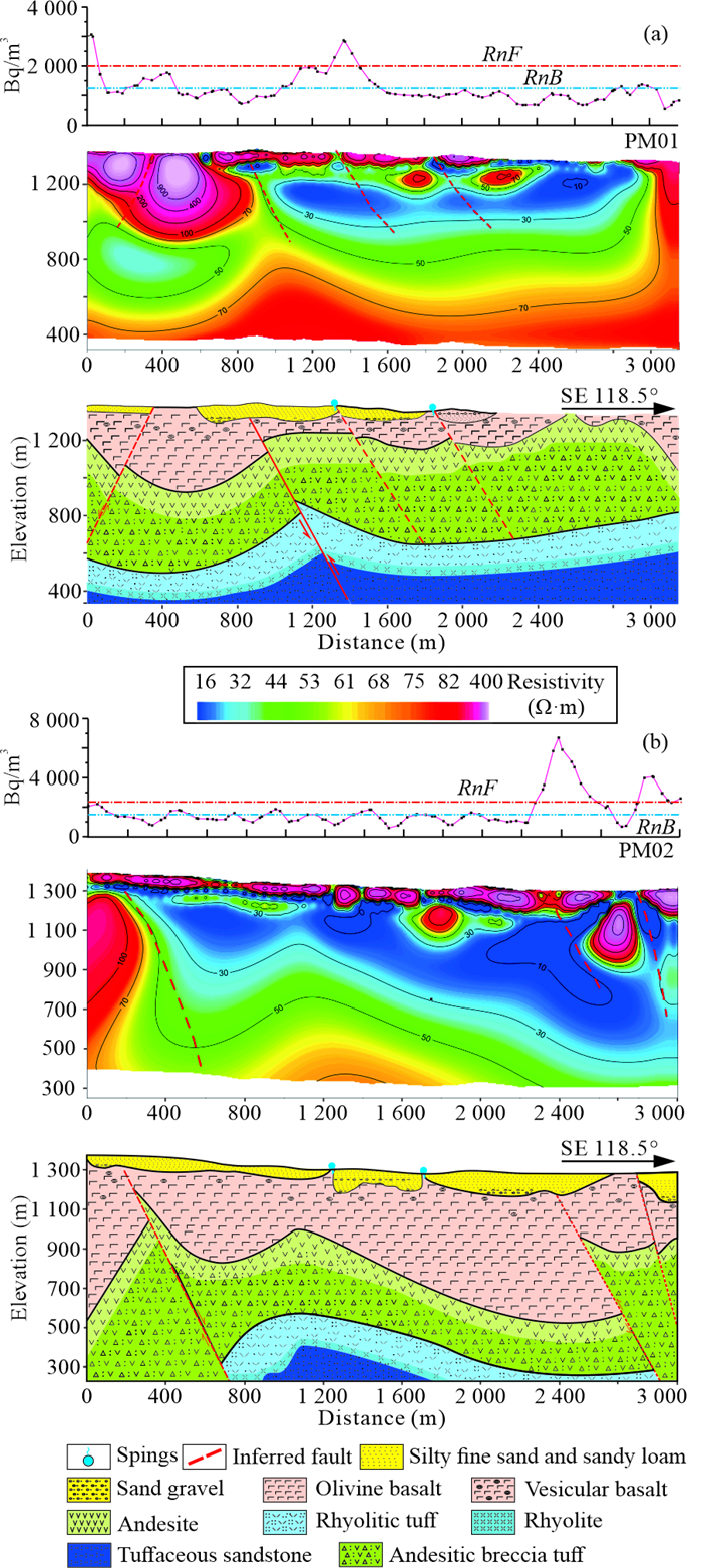
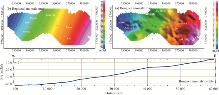
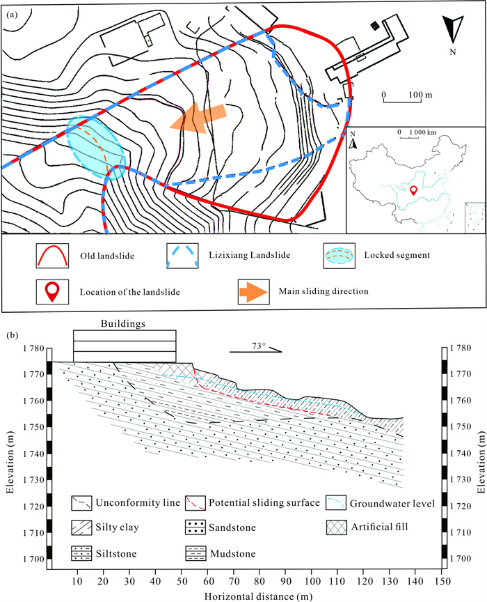
CorelKit is developed with the built-in VBA environment of CorelDraw®, and is a new plug-in in CorelDraw for geological and geochemical drawing. CorelKit can help users quickly and easily draw geological and geochemical graphs, such as scatterplot, triangular scatterplot, line chart, histogram, bar chart, box plot, pie graph, etc. In order to adapt to the geological application, the above functions are strengthened. Scatterplot and triangular scatterplot provide nearly 150 common basemaps, covering rock classification, structural environment discrimination, mineral genesis, isotope geochemistry, etc., for the convenience of the user mapping. Meanwhile, CorelKit further provides a structural joint rose diagram and sulfur isotopic composition diagram. This software also has many practical functions such as Bézier line topology, Multiple Bézier lines close fill, Single inner fill, Correction basemap, Add a compass, Add a scale, which facilitates daily geological drawing. The software has a friendly interface, in both Chinese and English versions, and is suitable for CorelDraw X4 and later versions. We introduced the Bézier line topology to CorelKit for the first time, which is similar to the GIS® topology for geological maps. According to the "GB/T 958-2015 Geological Legends Used for Regional Geological Map", a two-color filling library of rock pattern pictures is established, which is convenient to realize the two-color filling of sedimentary rocks, metamorphic rocks and magmatic rocks patterns. Obviously, CorelKit makes up for many shortcomings of CorelDraw in geosciences and is a very practical tool for geoscience researchers.

Thermal Equation of State of Natural F-Rich Topaz up to 29 GPa and 750 K
Yungui Liu, Xiang Li, Haipeng Song, Jingui Xu, Dongzhou Zhang, Junfeng Zhang, Xiang Wu
2023, 34(3): 758-766. doi: 10.1007/s12583-021-1418-y
Abstract:

Subducting oceanic sediments and crusts, originating from the Earth's surface and descending into its deep interior, are important carriers of volatiles. The volatiles have significant effects on materials cycling and the dynamic evolution of the subduction zones. A simplified Al2O3-SiO2-H2O (ASH) ternary system models the relationship of minerals in the hydrated and alumina-silica rich sedimentary layer. Topaz Al2SiO4(F, OH)2 is an important mineral in the ASH system and comprises two volatiles: H2O and fluorine (F). In this study, the thermoelasticity of a natural F-rich topaz was investigated using synchrotron-based single-crystal X-ray diffraction combined with diamond anvil cells up to 29.1 GPa and 750 K. The pressure-volume-temperature data were fitted to a third-order Birch-Murnaghan Equation of state with V0 = 343.15(7) Å3, K0 = 166(1) GPa, K0' = 3.0(1), (∂K0/∂T)P = -0.015(9) GPa/K and α0 = 3.9(5) × 10-5 K-1. The isothermal bulk modulus increases with the F content in topaz, and the various F contents present significant effects on its anisotropic compressibility. Our results further reveal that the isothermal bulk modulus K0 of the minerals in ASH system increases with density. F and H contents in hydrous minerals might greatly affect their properties (e.g., compressibility and stability), providing more comprehensive constraints on the subduction zones.

Deformation of the Subcontinental Lithospheric Mantle in NE China: Constraints from Rheological and Fabric Study of Mantle Peridotite Xenoliths from Jiaohe, Jilin Province
Wei Gan, Zhenmin Jin, Ziqi Fang, Wenlong Liu
2023, 34(3): 767-775. doi: 10.1007/s12583-020-1063-x
Abstract:

Mantle peridotite xenoliths in Jiaohe City, located near the northern part of the Tan-Lu fault, are key evidence for constraining the nature and evolution of the subcontinental lithospheric mantle (SCLM) of the NE China. Geochemical characteristics of Jiaohe peridotite xenoliths have been well studied, whereas the microstructures and associated fabrics remain poorly known. We report here major element composition of the constituent minerals, P-T conditions, microstructure, lattice preferred orientations (LPOs) of a set of xenoliths having coarse-grained and granuloblastic to porphyroclastic textures. These xenoliths are characterized by forsterite content of 89–91 in olivine. Dislocation microstructures, in olivine crystals revealed by oxidation decoration technique, are characterized by free dislocation, dislocation walls, dislocation loops and subgrains. Microstructures and deformation mechanism maps indicate that dislocation creep is the dominant deformation mechanism of almost anhydrous olivine in the SCLM. In most samples, the observed LPOs of olivine are typical A-type fabric. Stresses measured in the xenoliths using several olivine piezometers are ~2.7–8.5 MPa. The equilibration temperature conditions, calculated using several geo-thermometers, indicate the equilibrium temperature condition of peridotites in a range of 891 to 993 ℃. These results provide rheological constraint on the deformation of the SCLM in Jiaohe. Combined with the data for mantle xenoliths from adjacent regions, a heterogeneous evolution of the lithosphere deformation is inferred at the Jiaohe region. We propose that characteristics of the studied peridotite may be related to the Tan-Lu fault.

Mineral Deposits
Exhumation History and Exploration Potential of Gold Deposits in the NE Jiaodong Peninsula, North China: Evidence from Apatite and Zircon Fission Track Thermochronology
Yuanlin Chen, Huan Li, Chaoyang Zheng, Safiyanu Muhammad Elatikpo, Liu'an Duan, Bo Feng, Dadou Li, Rehan Khan
2023, 34(3): 776-789. doi: 10.1007/s12583-021-1558-0
Abstract:

As the most important gold producer in China, the Northwest Jiaodong Peninsula is famous for its large gold deposits. In recent years, the discovery of gold mineralization has reached a depth of 4 000 m below the surface in this region. It has attracted significant interest from explorers about the prospecting potential at greater depths. Besides, the current deep drilling shows that the prospecting effect in the west portion is better than the region to the east. Does it imply that there is a difference in prospecting potential between the east and the west? This paper seeks to address the issue through fission track thermochronology on apatite and zircon to reveal the temperature-time evolution relationship of rock mass and to inverts their thermal evolution history. In addition, this study analyzes the transformation of ore deposits after mineralization, quantitatively calculates the uplift-erosion rate of rock mass, and summarizes the preservation law of ore deposits. Based on the thermal history simulation of the apatite fission track, our results show that the Guocheng gold belt has experienced three stages of thermal evolution: 108–74, 74–27, and 27–0 Ma. The uplift and cooling processes of the three-stage tectonic uplift events are the results of multi-stage Pacific plate accretion. The calculated total denudation depth of the gold deposit in the Guocheng gold belt from Cretaceous to the present is about 3.4–5.3 km. The metallogenic depth of the ore body in the gold belt is 5.6–8.0 km, which indicates that the ore body in the Guocheng gold belt has suffered a significant degree of denudation. It is speculated that the location with less denudation in the southwest has greater prospecting potential. Our results quantitatively identify the uplift and denudation of the deposit after mineralization, which provides a new theoretical reference for regional mineralization, deep prospecting and exploration.

Geochronology and Geochemistry of Wangjiadashan Quartz Syenite Porphyry in Suizao Area of Hubei Province in the Tongbai-Dabie Orogenic Belt
Pan-Pan Niu, Shao-Yong Jiang
2023, 34(3): 790-805. doi: 10.1007/s12583-020-1383-x
Abstract:

The Wangjiadashan area in Suizhou-Zaoyang region of Hubei Province in the Tongbai-Dabie orogenic belt hosts important copper-gold deposits and contains a large number of quartz syenite porphyry dykes, occurring mostly along the NEE-trend faults. In this study, we used LA-ICP-MS zircon U-Pb dating method and obtained an age of 143.6 ± 1.4 Ma, which represents the emplacement of these quartz syenite porphyry dykes was at the Yanshanian, but it was slightly earlier than the previously reported ages (139–135 Ma) for granites widespreading in Suizao area. The geochemical data of the Wangjiadashan quartz syenite porphyry show high K2O, CaO, Na2O and Al2O3 contents but extremely low MgO contents (0.01 wt.%–0.46 wt.%). The geochemical characteristics indicate that these quartz syenite porphyry dykes belong to the typical C-type adakite and were possibly formed in the post-collisional environment. Multi-isotopic (Sr-Nd-Pb-Hf) analyses indicate that these quartz syenite porphyry dykes were originated from crust without distinct mantle materials involved. It is suggested that the Wangjiadashan quartz syenite porphyry was generated from partial melting of the thickened lower continental crust, and garnet but no plagioclase was left as residual phase. Compared with the widespread granites of the Tongbai area, the Wangjiadashan quartz syenite porphyry formed earlier and derived from more juvenile and K-rich lower crust, while they all belong to intensive magmatism concentrated during the Early Cretaceous epoch in the Tongbai area.

Petroleum Geology
Reservoir Quality and Controlling Mechanism of the Upper Paleogene Fine-Grained Sandstones in Lacustrine Basin in the Hinterlands of Northern Qaidam Basin, NW China
Lei Gong, Xianzhi Gao, Futao Qu, Yongshu Zhang, Guangya Zhang, Jun Zhu
2023, 34(3): 806-823. doi: 10.1007/s12583-022-1701-6
Abstract:

The Upper Paleogene lacustrine fine-grained sandstones in the hinterlands of the northern Qaidam Basin mainly contain two sweet spot intervals. Fracture/fault, microfacies, petrology, pore features, diagenesis, etc., were innovatively combined to confirm the controlling factors on the reservoir quality of shallow delta-lacustrine fine-grained sandstones. The diagenesis of the original lake/surface/meteoric freshwater and acidic fluids related to the faults and unconformity occurred in an open geochemical system. Comprehensive analysis shows that the Upper Paleogene fine-grained sandstones were primarily formed in the early diagenetic B substage to the middle diagenetic A substage. Reservoir quality was controlled by fault systems, microfacies, burial-thermal history, diagenesis, hydrocarbon charging events (HCE), and abnormally high pressure. Shallow and deep double fault systems are the pathways for fluid flow and hydrocarbon migration. Sandstones developed in the high energy settings such as overwater (ODC) and underwater distributary channels (UDC) provide the material foundation for reservoirs. Moderate burial depth (3 000–4 000 m), moderate geothermal field (2.7–3.2 ℃/100 m), and late HCE (later than E3) represent the important factors to protect and improve pore volume. Meteoric freshwater with high concentrations of CO2 and organic acids from thermal decarboxylation are the main fluids leading to the dissolution and reformation of feldspar, rock fragments, calcite and anhydrite cements. Abnormally high pressure caused by the undercompaction in a large set of argillaceous rocks is the key to form high-quality reservoirs. Abnormal pressure zones reduced and inhibited the damage of compaction and quartz overgrowth to reservoir pores, allowing them to be better preserved. A reservoir quality evaluation model with bidirectional migration pathways, rich in clay minerals, poor in cements, superimposed dissolution and abnormally high pressure was proposed for the ODC/UDC fine-grained sandstones. This model will facilitate the future development of fine-grained sandstone reservoirs both in the Upper Paleogene of the Qaidam Basin and elsewhere.

Structure and Evolution of Clay-Organic Nanocomposites in Three Leading Shales in China
Yuantao Gu, Quan Wan, Xiaoxia Li, Tao Han, Shuguang Yang, Qinhong Hu
2023, 34(3): 824-837. doi: 10.1007/s12583-022-1717-y
Abstract:

Organic matter (OM) in shales occurs as nanometer-sized intercalations with clay minerals that are termed as clay-organic nanocomposites; however, the OM occurrence in nanocomposites at different stages of maturation is still unclear, and the co-evolution process of OM and clay under burial is not well understood. To reveal the variation of OM occurrence and clarify the relationship between petroleum generation of OM & transformation of clay minerals in nanocomposites as a function of maturity, this study investigates the structure and clay-OM association in 44 samples from three leading shales at different maturity stages from two basins in China. A total of 15 samples of lacustrine shale from upper Triassic Yanchang Formation, 15 samples of marine shale from Lower Silurian Longmaxi Formation, and 14 samples of marine shale from Lower Cambrian Niutitang Formation were analyzed based on organic geochemistry, X-ray diffraction (XRD), and field emission-scan electron microscopy (FE-SEM), focused ion beam (FIB) sample preparation and consequent high resolution-transmission electron microscopy (HR-TEM) observations combined with energy dispersive spectroscopy (EDS). The results from this study show that most shale samples are organic-rich, and these three shales represent thermal evolutionary process from oil-window mature to overmature in a sequence of Triassic Yanchang, Silurian Longmaxi, and Cambrian Niutitang formations. Thorough observations indicate that sub-parallel bands of clays and intermingling of detrital minerals (such as quartz) dominate the nanocomposites in the Yanchang samples. While for Longmaxi and Niutitang shales, abundant nanopores and pyrite nanoparticles are observed in nanocomposites with features of layered distributions of OM and clay minerals. The structural investigation of nanocomposites shows that organic carbon between multi-layers dominates the OM occurrence in nanocomposites, which significantly extends the traditional opinion of OM-clay association. At an oil-window mature stage, the fluctuational interlayer spacing and a certain intensity of the carbon peak observed in the EDS spectra for corresponding clays provide a visual evidence of the organic molecules accessing the monolayer spaces of smectite. With the evolutional process of nanocomposites in shale and petroleum generation of OM & mineral transformation (illitization of smectite) running in parallel, it is inferred that the organic molecules migrate from monolayer spaces as gaseous hydrocarbons are generated, and eventually form stable clay-organic nanocomposites at an overmature stage. The results presented here will contribute to an improved understanding of diagenesis and organic-inorganic interactions in OM-rich shales.

Hydrogeology and Environmental Geology
Geochemical Characteristics and Origin of Nuanquanzi Geothermal Water in Yudaokou, Chengde, Hebei, North China
Houyun Sun, Xiaoming Sun, Xiaofeng Wei, Xingkai Huang, Guoqiu Ke, Hao Wei
2023, 34(3): 838-856. doi: 10.1007/s12583-022-1635-z
Abstract:

Study on the Nuanquanzi geothermal field in the Yanshan uplift is of great significance for understanding the origin of geothermal fluid in the intracontinental orogenic belt of the fault depression basin margin in North China. The geochemical characteristics and formation mechanism of the Nuanquanzi geothermal system were elucidated by classical hydrogeochemical analysis, multi-isotopes approach (δD, δ18O, δ13C, δ87Sr/86Sr), 14CAMS dating, and integrated geophysical prospecting of surface-soil radon gas measurement and CSAMT inversion. The results show that the Nuanquanzi geothermal field is a medium-low temperature convection-fault semi-enclosed geothermal system. The hydrochemical type of thermal water is primarily HCO3-Na, and rich in soluble SiO2, F- and Cl-. The geothermal water primarily originated from the recharging meteoric water with a maximum circulation depth of 2 400– 3 200 m, but affected by the mixing of endogenous sedimentary water. The reservoir temperature calculated by Na-K and quartz geothermometer of the Nuanquanzi geothermal system was determined to be 73.39–92.87 ℃. The conduction-cooling and shallow cold-water mixing processes occurred during the parent geothermal fluid ascent to surface, and the proportion of cold-water mixing during circulation was approximately 88.3% to 92.2%. The high-anomaly radon zones matched well to the low apparent-resistance areas and hiding faults, indicating that the Nuanquanzi geothermal field was dominated by a graben basin restricted by multiple faults.

Arsenic Removal from Groundwater Using Iron Pyrite: Influence Factors and Removal Mechanism
Muhammad Yousuf Jat Baloch, Chunli Su, Shakeel Ahmed Talpur, Javed Iqbal, Kulvinder Bajwa
2023, 34(3): 857-867. doi: 10.1007/s12583-022-1698-x
Abstract:

Iron pyrite has been reported as a kind of potential material for arsenic (As) removal from the groundwater because it exhibits a strong attraction in groundwater for both arsenite and arsenate species. In this study, batch adsorption experiments were carried out to determine the optimum conditions for As adsorption by the iron pyrite adsorbent, including the initial concentration, adsorbent dosage ratio, pH, temperature and stirring rate. Precisely characterization methods were employed to identify the mechanism of As removal. Maximum removal efficiency for As(Ⅲ) was observed 93% at pH = 7, and for As(Ⅴ) was 95% observed at pH = 5. Langmuir model resulted in the maximum adsorption capacity (qm) for As(Ⅲ) and As(Ⅴ) were 571.7 and 671.1 μg/g, respectively, as well as the experiments were found to be favorable as separation factor RL < 1. The value of "n" 2.68 and 2.47 for As(Ⅲ) and As(Ⅴ) obtained by Freundlich model (n > 1) indicates favorable adsorption. The pseudo-first and second-order kinetic models also fitted well. The addition of oxalate on the adsorbent surface plays an important role for the recycling of Fe(Ⅱ)/Fe(Ⅲ) to minimize the arsenic concentration. Specific surface area, ion exchange mechanism and structure of adsorbent confirmed that addition of oxalate could enhance the surface area of adsorbent.

Flood Duration Estimation Based on Multisensor, Multitemporal Remote Sensing: The Sardoba Reservoir Flood
Limei Wang, Guowang Jin, Xin Xiong
2023, 34(3): 868-878. doi: 10.1007/s12583-022-1670-9
Abstract:

Single-sensor monitoring of flood events at high spatial and temporal resolutions is difficult because of the lack of data owing to instrument defects, cloud contamination, imaging geometry. However, combining multisensor data provides an impressive solution to this problem. In this study, 11 synthetic aperture radar (SAR) images and 13 optical images were collected from the Google Earth Engine (GEE) platform during the Sardoba Reservoir flood event to constitute a time series dataset. Threshold-based and indices-based methods were used for SAR and optical data, respectively, to extract the water extent. The final sequential flood water maps were obtained by fusing the results from multisensor time series imagery. Experiments show that, when compare with the Global Surface Water Dynamic (GSWD) dataset, the overall accuracy and Kappa coefficient of the water body extent extracted by our methods range from 98.8% to 99.1% and 0.839 to 0.900, respectively. The flooded extent and area increased sharply to a maximum between May 1 and May 4, and then experienced a sustained decline over time. The flood lasted for more than a month in the lowland areas in the north, indicating that the northern region is severely affected. Land cover changes could be detected using the temporal spectrum analysis, which indicated that detailed temporal information benefiting from the multisensor data is highly important for time series analyses.

Geophysics
Early Cretaceous Tectonostratigraphic Evolution of the Southern Tunisian Margin Based on Gravity, Seismic and Potential Field Data: New Insights into a Geodynamic Evolution in a Tethyan and Mesogean Rifting Context
Mohamed Ben Chelbi
2023, 34(3): 879-899. doi: 10.1007/s12583-021-1540-x
Abstract:

Many geophysical and geological data have been used to interpret the tectonic evolution of the south-eastern part of the Tunisian margin and to analyze the dominant structures in the area. The Menzel Habib Plain (MHP) and surroundings, targeted by this study, exhibits thick siliciclastic and carbonate formations attributed to the Early Cretaceous period. Integration of seismic and gravimetric data coupled with analysis of the syndepositional faults affecting these formations prove that the Tunisian margin is dominated, during this period, by N-S to NE-SW extensional directions. The geodynamic evolution of the MHP is mainly due to the irregular normal movement of the N-S faults, which represents the southernmost branch of the N-S Axis (NSA) and of the NW-SE faults, which constitutes the SE segment of the South Atlasic fault corridor (SAFC). In addition, the NE-SW and E-W oriented faults contributed to this evolution. Over extensive periods, this network of faults determines horst and grabens basin geometry or tilted blocks inducing formation of several distinct areas with different subsidence rates. Simultaneously, the normal activity of the major faults promotes the vertical mobilization of the Triassic salt resulting in the individualization of several diapiric bodies, some of which pierced their sedimentary cover. These dynamics reflect echoes of the sinistral drifting of Africa with respect to Europe, integrated in a long Tethyan rifting cycle, and the beginning of opening of the Mesogean Sea, respectively.

Micro-Earthquake Seismicity and Tectonic Significance of the 2012 Ms 4.9 Baoying Earthquake, Jiangsu, China
Yanzhen Li, Hongyi Li, Yafen Huang, Shengzhong Zhang, Yuejun Lü
2023, 34(3): 900-910. doi: 10.1007/s12583-022-1780-4
Abstract:

On July 20, 2012, the Ms 4.9 Baoying Earthquake occurred near the junction of Baoying County and Gaoyou City in Jiangsu Province, eastern China. Due to no obvious surface rupture and limited observation of earthquake sequence, the seismogenic structure of the Ms 4.9 Baoying Earthquake is still unclear. In this study, 80 earthquakes provided by China Earthquake Network Center (CENC) are first relocated; and then the relocated 75 events with high signal-to-noise ratios as templates are utilized to scan through continuous waveform data (July 11 to August 31, 2012) using graphics processing unit-based match and locate (GPU-M&L) technique. Then the DeepDenoiser, a deep-learning-based noise reduction technique, is used to further confirm some newly detected events; and the double-difference relocation (HypoDD) algorithm is used to relocate the earthquakes. We detect and relocate more than twice as many events as the CENC routine catalog, which includes 15 foreshocks and 230 aftershocks. The results show that the foreshocks are mainly distributed in the NW direction along the extended SE section of the blind Xiagonghe fault (XF), which is orthogonal to the strike of the seismogenic fault of the Ms 4.9 Baoying Earthquake (Yangchacang-Sangshutou fault, named YSF). Most of the aftershocks are generally distributed along the NNE-trending YSF and illuminate a steeply dipping plane. This study reveals detailed spatiotemporal evolution of the earthquake sequence and suggests that the buried XF extends southeastward and cuts through the NNE-trending seismogenic YSF.

Engineering Geology and Geo-hazards
Dynamic Response and Deformation Behavior of Kadui-2 Landslide Influenced by Reservoir Impoundment and Rainfall, Baoxing, China
Muhammad Kamran, Xiewen Hu, Muhammad Awais Hussain, Muhammad Sanaullah, Randa Ali, Kun He
2023, 34(3): 911-923. doi: 10.1007/s12583-022-1649-6
Abstract:

This study focuses on the deformation characteristics of Kadui-2 Landslide by the influence of reservoir filling-drawdown and precipitation. A three-year monitoring project was implemented in order to observe the short/long-term deformation. The slide mass experienced consistent deformation with a maximum cumulative displacement of 331.34 cm. Based on the recorded data of reservoir water level and precipitation during this period, a two-dimensional (2-D) finite element model using Geostudio software was set up for deformation simulation under different conditions to understand the real influence of these triggering factors on landslide. The numerical simulation results are in consistent with monitoring field data. Both numerical simulation and field monitoring results exhibit that the maximum deformation occurred at the foreside of slumping mass. The slip surface shows significant creep characteristics decreasing as long-term shear strength reducing gradually. Reservoir water level fluctuation is the primary triggering factor to reactivate the landslide mass and has a negative correlation with deformation rate. Displacement rate increases with the reservoir drawdown and decreases with impoundment rise. Compared with reservoir filling-drawdown operation, rainfall has no significant effect on the slide motion of landslide due to limited penetration from the ground surface.

Study on Geomechanical and Physical Models of Necking-Type Slopes
Kun Fang, Huiming Tang, Jichen Zhu, Zijin Fu, Pengju An, Bocheng Zhang, Chunyan Tang
2023, 34(3): 924-934. doi: 10.1007/s12583-021-1573-1
Abstract:

A simplified geomechanical model was proposed by considering three typical necking-type slopes; this model lays a foundation for the further investigation of the deformation behaviors of such slopes. Three physical models of necking-type slopes were built according to the geomechanical model with slope evolution stages. Finally, preliminary calculations related to the arching effect in the physical model were conducted. Three evolution stages of necking-type slopes, namely, the initial stage, compression stage, and failure stage, were presented based on the formation and disappearance of the arching effect within the slope. The specific parameters of the geomechanical model were given. In the setup of the tilting test, the failure angle of the necking-type slope model was calculated to be approximately 50° with a large lateral resistance coefficient. The proposed geomechanical model and physical models of necking-type slopes provide guidance for the establishment of geomechanical and physical models of landslides at specific sites.

Development of a New in-situ Interface Shear Box Test Apparatus and Its Applications
Kewen Yu, Ling Xu, Jianbing Peng, Lu Zuo, Guangxi Guan
2023, 34(3): 935-939. doi: 10.1007/s12583-023-1848-9
Abstract:
Evolution History of Mesas in the Southern Utopia Planitia and Implications for the Ancient Oceans on Mars
Tengfei Zhang, Le Wang, Arzigul Saidamat, Long Xiao, Jun Huang
2023, 34(3): 940-950. doi: 10.1007/s12583-022-1776-0
Abstract:

As one of the prominent landforms in the Zhurong landing region, mesas are geological features with flat tops and steep marginal cliffs. The mesas are widely distributed along the dichotomy boundary. There are various interpreted origins proposed for the mesas, such as the erosion of sedimentary layers, tuyas eruptions, or surface collapse due to the catastrophic release of groundwater. We investigate the detailed morphological characteristics of the mesas on the Late Hesperian Lowland unit within the Utopia Planitia. We observe morphological evidence for both the ice-bearing interior mesas and the sedimentary origin, including (1) small pits on the crater wall and mesa cliff formed by the release of volatiles like ice; (2) lobate flows at the base of mesas formed by the melting of subsurface ice; (3) layered mesas indicating sedimentary origin; (4) grooves on the top surface of mesas formed by the volumetric compaction of sedimentary deposits. The results indicate that the mesas in the study area are formed by the erosion of sedimentary layers and representative of the Noachian oceanic sediments. We propose an evolutionary model for the mesas. This study will provide some insights into future research of ancient ocean hypothesis of Mars and interesting targets for the exploration of the Zhurong rover.