Advanced Search

Indexed by SCI、CA、РЖ、PA、CSA、ZR、etc .

Current Issue

COVER
2025, 36(5): .
Abstract:
CONTENTS
2025, 36(5): .
Abstract:
Structural Geology
Trench-Perpendicular Mantle Flow Recorded by Late Mesozoic Intraplate Magmatism and Implications for the Formation of the Eastern Asian Big Mantle Wedge
Si-Wen Zhang, Feng Wang, Ren-Yi Jia, Wen-Liang Xu, Yi-Ni Wang, De-Bin Yang, Hai-Hong Zhang
2025, 36(5): 1879-1891. doi: 10.1007/s12583-025-0220-7
Abstract:

The Paleo-Pacific Plate stagnated in the mantle transition zone beneath northeast Asia during the Late Mesozoic, resulting in the eastern Asian big mantle wedge (BMW). However, its formation mechanism remains unclear. Here, we analyzed elemental and isotopic compositions of 126–60 Ma intraplate basaltic rocks to map the mantle flow pattern and investigate the implications for the formation of the BMW. These rocks exhibit eastward an increase in Ba/Nb, Ba/La, 87Sr/86Sr, and 208Pb/204Pb ratios, while a decrease in Nb/Yb, Zr/Yb, Ta/Yb, and Nb/Nb* ratios, indicating mixing between the fertile mantle and the depleted mantle modified by slab material, implying the occurrence of trench-perpendicular mantle flow. The coeval mantle flow and formation of the BMW, the similar directions of mantle flow and Paleo-Pacific Plate subduction, and migration of basin depocenters indicate trench-perpendicular mantle flow was a key factor in the formation of the BMW. Moreover, these basaltic rocks have elevated δ66Zn values (0.22‰ to 0.52‰), indicating recycled carbonates have been added into their mantle source, which increased the mantle flow velocity. Combined with slab roll-back in the Late Mesozoic, it created the essential conditions for mantle flow to promote the formation of the eastern Asian BMW.

Mechanism of Crust Growth Constrained by Back-Calculated U/Pb Ratios of the New Continental Crust
Zhengzhe Fan, Xian Chen, Dehui Zhang, Hongqi Yuan
2025, 36(5): 1892-1905. doi: 10.1007/s12583-023-1830-6
Abstract:

The mechanism of continental crust growth remains ambiguous. A key constraint is determining which tectonic settings were involved in the formation of the new continental crust. Because the basalts formed in intraplate (OIB, mean U/Pb = ~0.37 ± 0.11) and subduction (IAB, mean U/Pb = ~0.10 ± 0.06) settings have distinct U/Pb ratios, thus we back-calculate the present-day U/Pb ratios of the New Continental crust source [(U/Pb)nc] based on our zircon-Hf and published whole rock-Pb isotope compositions of the Wulaga Ⅰ-type granite to unfold the mechanism of the crust growth in the Lesser Xing'an Range (LXR), of the eastern Central Asian orogenic belt (CAOB). The Wulaga granodiorite porphyry yields zircon U-Pb ages of 103 ± 1 Ma with εHf(t) of +6.0 to +9.0 and TDM2 of 590 to 784 Ma (averaging at 709 ± 100 Ma). This result indicates that the Early Cretaceous Wulaga granodiorite porphyry was derived from the Neoproterozoic juvenile basaltic crust. The back-calculated (U/Pb)nc values (0.15–0.18) may approximately represent the U/Pb ratios of the basaltic protolith of the Wulaga granite. It is similar to the U/Pb ratios in the IAB magmas within the calculation errors. Therefore, the crust growth of the LXR may occur through subduction at ca. 700 Ma. In addition, this geochemical method also has been successfully applied to unfold the mechanism of the crust accretion of both the Jibei area in North China at ca. 2.0 Ga and the Hongol area in the eastern CAOB during ca. 1.1–0.8 Ga. The back-calculation of the present U/Pb ratio of the protolith of Ⅰ-type granites in this study may constitute a potential method to constrain the mechanism of continental crustal accretion.

A Typical Riedel Shear Pattern of Active Faults in the Laolongwan Basin, Northeastern Tibetan Plateau
Kai-Xun Wang, Xiao-Gang Li, Wei Shi, Xiang-You Feng, Qian Yang, Jie Li, Zheng-Jian Xu, Zhou-Jun Peng, Shao-Hua Xu, Yi-Xue Xiong, Mao Lin
2025, 36(5): 1906-1922. doi: 10.1007/s12583-023-1831-5
Abstract:

Riedel shear system, which consists of some different oriented faults and derivative structures, is an important pattern of tectonic activity and stress regulation, which has been widely applied to the interpretation of intracontinental deformation. The Laolongwan Basin, located in the western Haiyuan fault zone at the northeastern Tibetan Plateau, is a key area to study the Cenozoic intracontinental deformation in the northeastern plateau, which formed a complex active fault system during the Cenozoic. However, the activity of these faults and their kinematic mechanism remain unclear. In this contribution, based on detailed structural interpretation of remote sensing image, field observations and OSL dating analysis, we propose a Riedel Shear model of active fault system in the Laolongwan Basin. Our observations show that this active fault system consist of four major faults, including the left strike-slip Hasi Shan fault and Zihong Shan fault with thrusting characteristics, the Southern Zihong Shan thrust fault and the Mijia Shan normal fault. The fault offset and OSL dating analyses suggest that the left-lateral slip rate of the Hasi Shan fault is ~2.60–3.01 mm/a since ca. 15 ka, whereas the Zihong Shan fault is ~1.10–1.13 mm/a since ca. 14 ka. Fault-slip vectors analyses indicate that the active fault system related to the Riedel Shear in the Laolongwan Basin was controlled by the regional ENE-WSW compressive stress. This compression also caused the significant left-lateral strike-slip movement along the Haiyuan fault zone at the same time, which might result from the northeastward continuous expanding of the Tibetan Plateau during the Late Cenozoic.

Engineering Geology
Effect of Spatial Variability in the Geometry of Fractures on Granite Slope Stability
Lin Jia, Jing-Sen Cai, Li Wu, Tian-Chyi Jim Yeh, E-Chuan Yan, Yi Du
2025, 36(5): 1923-1935. doi: 10.1007/s12583-023-1825-3
Abstract:

A DFN-DEC (discrete fracture network-distinct element code) method based on the MATLAB platform is developed to generate heterogeneous DFN. Subsequently, the effects of the spatial variability (the mean $ \mu $ and the standard deviation $ \sigma $) of the geometric properties (i.e., the fracture dip D, the trace length T and the spacing S) of both the gently-dipping (denoted with 1) and the steeply-dipping (denoted with 2) fractures on the stability of granite slope are investigated. Results indicate that the proposed DFN-DEC method is robust, generating fracture networks that resemble reality. In addition, the spatial variability of fracture geometry, influencing the structure of granite slope, plays a significant role in slope stability. The mean stability of the slope decreases with the increase of $ {\mu }_{{\mathrm{D}}_{1}} $ (the mean of gently-dipping fracture dip), $ {\sigma }_{{\mathrm{D}}_{2}} $ (the mean of steeply-dipping fracture dip), $ {\mu }_{{\mathrm{T}}_{1}} $ (the mean of gently-dipping fracture trace length), $ {\mu }_{{\mathrm{T}}_{2}} $ (the mean of steeply-dipping fracture trace length), $ {\sigma }_{{\mathrm{T}}_{1}} $ (the standard deviation of gently-dipping fracture trace length), $ {\sigma }_{{\mathrm{T}}_{2}} $ (the standard deviation of steeply-dipping fracture trace length), and the decrease of $ {\sigma }_{{\mathrm{D}}_{1}} $ (the standard deviation of gently-dipping fracture dip), $ {\mu }_{{\mathrm{D}}_{2}} $ (the standard deviation of steeply-dipping fracture dip), $ {\mu }_{{\mathrm{S}}_{1}} $ (the mean of gently-dipping fracture spacing) and $ {\mu }_{{\mathrm{S}}_{2}} $ (the mean of steeply-dipping fracture spacing). Among them, $ {\mu }_{{\mathrm{T}}_{1}} $, $ {\mu }_{{\mathrm{D}}_{1}} $ and $ {\mu }_{{\mathrm{S}}_{1}} $ have the major impact. When the fracture spacing is large, the variability in the fracture geometry becomes less relevant to slope stability. When within some ranges of the fracture spacing, the spatial varying of dips can increase the slope stability by forming an interlaced structure. The results also show that the effects of the variability of trace length on slope stability depend on the variability of dip. These findings highlight the importance of spatial variability in the geometry of fractures to rock slope stability analysis.

Mechanical Behavior of Sliding Zone Soil under Compression Considering Periodic Saturation-Drying: Example from a Giant Reservoir Landslide
Sha Lu, Huiming Tang, Liangqing Wang, Xuexue Su, Bing Lyu
2025, 36(5): 1936-1947. doi: 10.1007/s12583-023-1971-2
Abstract:

The reservoir landslide undergoes periodic saturation-drying cycles affected by reservoir fluctuation in hydropower project area, leading to the irreversible impact on the landslide materials. Sliding zone is the shearing part in formation of landslide and controls the further development of landslide. The mechanical behavior of sliding zone soil under compression is a crucial factor in the stability analysis in landslides. In this paper, the sliding zone soil from a giant landslide in the biggest hydropower project area, Three Gorges Reservoir Area, is taken as the research case. The particle-size distribution of the sliding zone soil from this landslide is studied and fractal dimension is adopted as representation. Periodic saturation-drying is introduced as the affecting factor on sliding zone soil properties. The triaxial compression test is conducted to reveal the mechanical behavior of the soil, including stress-strain behavior, elastic modulus, failure stress and strength parameters. These behavior of sliding zone soils with different fractal dimensions are studied under the effects of periodic saturation-drying cycles. The normalized stress-strain curves are displayed for further calculation. The data considering saturation-drying cycles are obtained and compared with the experimental results.

Strength Deterioration Characteristics of Soft and Hard Interbedded Rock Masses in Three Gorges Reservoir Area Induced by Wetting-Drying Cycles
Qiong Wu, Di Wang, Huiming Tang, Jintao Kang, Hongming Luo, Yuxin Liu, Shiyu Li, Bo Zhang, Zhiqi Liu, Zhiwei Lin
2025, 36(5): 1948-1962. doi: 10.1007/s12583-023-1915-0
Abstract:

The rock masses in the hydro-fluctuation zone of reservoir banks sustain wetting-drying cycles (WDC), thereby affecting the stability of the reservoir bank slope. In this paper, rock masses with argillaceous siltstone and silty mudstone interbedded in Badong Formation were taken as the research object to investigate the variation of strength parameters of soft and hard interbedded rock masses with WDC and dip angle through laboratory experiments and numerical experiments. Some attempts were made to reveal the mechanical properties deterioration mechanism of interbedded rock masses by quantitatively analyzing the contribution of strength parameters deterioration of hard rocks, soft rocks, and bedding planes to the strength parameters deterioration of rock masses. The results indicate that the logarithmic function could be used to describe the deterioration of each strength parameter of both argillaceous siltstone and silty mudstone and bedding plane with the number of WDC. The strength parameters of interbedded rock masses decrease as the number of WDC increases, with the largest decrease after the first cycle and then slowing down in the later cycles. The strength parameters initially decrease and then increase as the dip angles increase. The impact of deteriorated strength parameters of bedding planes and rocks on the deterioration of strength parameters of interbedded rock masses differs significantly with the dip angle, which can be divided into four typical ranges of different controlling factors.

Experimental Study on Failure Process and Hydrological Response of Granite Residual Soil Slope with Different Fissure Positions in Southern China
Liping Liao, Minghao Gong, Zhiquan Yang, Yingzi Xu, Wenzhi Wei, Yao Wei
2025, 36(5): 1963-1976. doi: 10.1007/s12583-022-1770-6
Abstract:

Granite residual soil slope is often destroyed, which poses great threats to Rong County in southeastern Guangxi, China. Heavy rainfall and fissures are the major triggering and internal factors. The fissure that controls the slope stability and the associated failure mechanisms remain unclear. The purpose of this study was to identify the controlling fissures through field investigation, elucidate the effect of its position, and analyze the failure process and hydrological response of residual soil slope through artificial flume model tests. The results comprised five aspects. (1) Surface weathering and unloading fissures could affect slope stability. (2) The failure processes with different fissure positions exhibited inconsistent characteristics. (3) The volume moisture content (VMC) had the most direct response at the fissure tip. The corresponding infiltration rate was the highest. The response time of pore water pressure (PWP) was longer than that of VMC. Fluctuations in PWP were associated with VMC and changes in the soil microstructure due to local deformation. (4) Slope failure was accompanied by serious soil erosion. This could be attributed to the infiltration direction and the interaction between soil and water. (5) Fissured soil slopes experienced five similar failure processes: sheet erosion and partial failure of the slope foot, occurrence of preferential flow and enlargement of the sliding area, creep deformation and tension fissure emergence, block sliding and gully erosion, and flow-slip.

Formation of the Soil Arch and Load Transfer Mechanism of a Slope due to Excavation by 3D Particle Flow Code Simulation
Chunyan Tang, Huiming Tang, Kun Fang, Xuexue Su, Sixuan Sun, Minghao Miao
2025, 36(5): 1977-1988. doi: 10.1007/s12583-023-1810-x
Abstract:

The soil arching effect is an important factor affecting the internal load transfer of excavation-induced slopes. Physical model tests are usually used for studying the soil arching effect. Although physical model tests can monitor local point loads to demonstrate changes in local stresses, changes in force chains inside slopes are rarely demonstrated by physical modelling, which restricts the understanding of load transfer. To explore overall changes in stresses in slopes from a more microscopic perspective, a numerical simulation of the slope under excavation was carried out. Using built-in code and fish function programming in PFC3D, the slope model was developed. Monitoring areas were set up to monitor the changes in stresses and force chains during excavation. The simulation results show that excavation width affects the size of deformation area, and the deformation area expands as excavation width increases. Excavation causes load transfer and the formation of soil arching in the slope. A mechanism is proposed to explain the effect of excavation on soil arching formation and load transfer. The numerical simulation is important for revealing the load transfer of slopes during excavation, and the research results have practical value for the prevention and mitigation of landslides caused by excavation.

Development of a Model Material Suitable for Reservoir Landslide Model Tests
Minghao Miao, Huiming Tang, Sha Lu, Changdong Li, Kun Fang, Yixiao Gu, Chunyan Tang
2025, 36(5): 1989-2004. doi: 10.1007/s12583-023-1818-2
Abstract:

In the physical model test of landslides, the selection of analogous materials is the key, and it is difficult to consider the similarity of mechanical properties and seepage performance at the same time. To develop a model material suitable for analysing the deformation and failure of reservoir landslides, based on the existing research foundation of analogous materials, 5 materials and 5 physical-mechanical parameters were selected to design an orthogonal test. The factor sensitivity of each component ratio and its influence on the physical-mechanical indices were studied by range analysis and stepwise regression analysis, and the proportioning method was determined. Finally, the model material was developed, and a model test was carried out considering Huangtupo as the prototype application. The results showed that (1) the model material composed of sand, barite powder, glass beads, clay, and bentonite had a wide distribution of physical-mechanical parameters, which could be applied to model tests under different conditions; (2) the physical-mechanical parameters of analogous materials matched the application prototype; and (3) the mechanical properties and seepage performance of the model material sample met the requirements of reservoir landslide model tests, which could be used to simulate landslide evolution and analyse the deformation process.

Analysis of Ancient Rongcharong Landslide Dam Failure Events in the Suwalong Reach of the Upper Reaches of the Jinsha River
Yongchao Li, Songfeng Guo, Bowen Zheng, Yu Zou, Shengyuan Song, Yiwei Zhang, Jianhua Yan, Muhammad Faisal Waqar, Khan Zada, Shengwen Qi, Jianping Chen
2025, 36(5): 2005-2022. doi: 10.1007/s12583-024-0052-x
Abstract:

Active tectonic movements and geological disasters frequently occur in the upper reaches of the Jinsha River, increasing the likelihood of landslides obstructing the river. Taking the ancient Rongcharong landslide dam failure events in the Suwalong reach as an example, this paper first analyzes the accuracy and applicability of the commonly used methods in calculating the peak flow of the dam failure, such as the empirical formula, the numerical method based on the physical mechanism, and the computational fluid dynamics (CFD) method. Then, the peak flood flow of the Rongcharong-dammed lake when it overflows the dam is determined to be 28 393-64 272 m3/s. At the same time, the failure process of landslide dam due to flood erosion was elucidated using the CFD method, which can be divided into three stages: gradual erosion in the initial stage, rapid development in the middle stage, and gradual expansion in the final stage. Finally, the factors that affect the peak flow of floods are analyzed, and suggestions for emergency treatment of landslide dams are put forward. The findings of this research can serve as a valuable reference for disaster prevention and mitigation strategies to adapt to the increasing frequency of landslide-induced river blockages.

Mineral Deposits
What Controls the Distribution of Ore Veins in Quartz Vein-Type Tungsten Deposits: Constrains from Fan-Shaped Mineralization in SE China
Gui-Cong Fang, Deng-Hong Wang, Fu-Qiang Yang, Zhan-Xu Ni, Chang-Shuai Huang, Ping Wang, Meng Feng, Zuo-Hai Feng
2025, 36(5): 2023-2037. doi: 10.1007/s12583-024-0044-x
Abstract:

Quartz vein-type tungsten deposits are a common W deposit type. Their ore vein distribution was previously considered to be controlled by regional horizontal tectonic stress. In this paper, 14 tungsten deposits with fan-shaped mineralization in SE China are summarized, and the relations between their ore veins and granite and the ore-forming structural stress field are analyzed. These deposits have a post-magmatic hydrothermal genesis and involve the formation of two sets of veins with similar strike and opposite dips at the top of the ore-causative granite bodies, forming a vertical fan-shaped profile. Their ore veins were coeval with the underlying granite bodies, and generally extend along the long axis of the granite. In such fan-shaped ore formation, the stress is highly focused at the top of the granite and gradually weakens outward. The maximum principal stress (σ1) is perpendicular to the granite contact surface, and radiates outward from the pluton. Meanwhile, the minimum principal stress (σ3) forms an arc-shaped band parallel to the contact surface. Our findings, together with published numerical modeling indicate that the emplacement dynamics of granitic magma (rather than regional horizontal tectonic stress) are essential controls on the distribution of ore veins in quartz vein-type tungsten deposits.

Three-Dimensional Prospectivity Modeling of Jinshan Ag-Au Deposit, Southern China by Weights-of-Evidence
Fan Xiao, Qiuming Cheng, Weisheng Hou, Frederik P. Agterberg
2025, 36(5): 2038-2057. doi: 10.1007/s12583-023-1822-6
Abstract:

To comprehensively utilize the valuable geological map, exploration profile, borehole, and geochemical logging data and the knowledge on the formation of the Jinshan Ag-Au deposit for forecasting the exploration targets of concealed ore bodies, three-dimensional Mineral Prospectivity Modeling (MPM) of the deposit has been conducted using the weights-of-evidence (WofE) method. Conditional independence between evidence layers was tested, and the outline results using the prediction-volume (P-V) and Student's t-statistic methods for delineating favorable mineralization areas from continuous posterior probability map were critically compared. Four exploration targets delineated ultimately by the Student's t-statistic method for the discovery of minable ore bodies in each of the target areas were discussed in detail. The main conclusions include: (1) three-dimensional modeling of a deposit using multi-source reconnaissance data is useful for MPM in interpreting their relationships with known ore bodies; (2) WofE modeling can be used as a straightforward tool for integrating deposit model and reconnaissance data in MPM; (3) the Student's t-statistic method is more applicable in binarizing the continuous prospectivity map for exploration targeting than the P-V approach; and (4) two target areas within high potential to find undiscovered ore bodies were diagnosed to guide future near-mine exploration activities of the Jinshan deposit.

Geochemistry and Detrital Zircon U-Pb Chronology of Late Mesozoic Strata in the Western Erlian Basin and Their Indication to Provenance and Uranium Metallization
Reng-An Yu, Tong Li, Qiang Zhu, Qinghong Si, Jiarun Tu, Shenglong Peng, Yongxiang Tang
2025, 36(5): 2058-2074. doi: 10.1007/s12583-023-1820-8
Abstract:

The Erlian Basin is one of the most important multi-energy basins in China. The Baiyanhua area of the Chuanjing depression in the western Erlian Basin has recently become a favorable area for new progress in sandstone-type uranium prospecting. However, the Cretaceous source-to-sink evolution of the Chuanjing depression in the Erlian Basin is poorly known. This paper presents the systematic geochemical and zircon U-Pb studies on the Saihantala Formation and Erlian Formation in the Baiyanhua area. The data obtained are functionally important for revealing the provenance and tectonic setting of the source rocks. The results show that the upper part of the Saihantala Formation and the lower part of the Erlian Formation are mainly composed of felsic sedimentary rocks. The source rocks originated from a continental margin arc environment in terms of tectonic setting. The detrital zircons ages have the dominant populations at ca. 250–270 Ma, with two subdominant age groups at ca. 1 400–1 800 and 1 900–2 100 Ma, respectively. Combined with the tectono-sedimentary evolution of the Chuanjing depression, we conclude that: (1) the provenance of the Cretaceous strata was mostly sourced from the Baiyanhua uplift; (2) the water depth became shallow in the Southern Sangendalai sag during the middle period of Saihantala, further preventing the formation of coal beds; (3) the formation of Baiyanhua uplift might provide the beneficial tectonic condition for uranium mineralization in the upper Saihantala Formation in southern Sangendalai sag. This is significant for us to understand the space allocation of coal and uranium in Chuanjing depression and evaluate the uranium metallogenic prospects in southern Sangendalai sag.

Magmatic Processes of the Lingshan Granitic Batholith in the Dabie Orogen, Central China: Insights into Dabie-Type Porphyry Mo Mineralization
Jiang Zhu, Zhanke Li, Guohu Wang, Xianbin Shi, Yang Wang, Chao Chen, Song Chen, Yuanbing Zou
2025, 36(5): 2075-2093. doi: 10.1007/s12583-023-1914-1
Abstract:

Dabie-type porphyry Mo deposits were proposed as a new type of porphyry Mo deposits, and had unique geological characteristics. It is still poorly understood about the magmatic processes that led to the Dabie-type Mo mineralization. Here, we present zircon U-Pb and Lu-Hf isotopic, whole-rock and biotite elemental, and whole-rock Sr-Nd isotopic analyses on the Lingshan granitic batholith in the Dabie Orogen. It consists of three units (Ⅰ to Ⅲ) that were emplaced before, genetically accompanied with, and after the Mo mineralization. LA-ICP-MS zircon U-Pb dating yielded crystallization ages of 128.2 ± 1.0 Ma (MSWD = 1.14) for Unit Ⅰ and ages of 127.8 ± 1.2 Ma (MSWD = 0.28) and 126.6 ± 1.8 Ma (MSWD = 1.6) for Unit Ⅱ, indicating that they were emplaced during 130 to 125 Ma. The granites have high SiO2 contents (75.84 wt.% to 78.94 wt.%) and low MgO contents (0.07 wt.% to 0.10 wt.%), and are classified as fractionated Ⅰ-Type granite. Units Ⅰ and Ⅱ have similar Sr-Nd isotopic ratios (εNd(t) = -16.2 to -17.2, (87Sr/86Sr)i = 0.705 40 to 0.706 92) and zircon εHf(t) values (-17.4 to -20.4), indicating they were derived from partial melting of the ancient Yangtze lower crust. Mo mineralized granite from Unit Ⅱ is characterized by the lower oxygen fugacity, fluorine enrichment and high fractionation. Magmas of units Ⅰ and Ⅱ have experienced fractional crystallization, with the assimilation of supracrustal materials that account for the increased TiO2, F and Mo contents, and the decreased ƒO2. We proposed that the assimilation in upper-crustal magmatic processes plays key factors for magmatic systems that led to the Dabie-type porphyry Mo deposits.

Sedimentary Structure Characteristics and Spatial Distribution Pattern of the Zhaoji Salt Mine Derived from Dense Array Ambient Noise Tomography
Hongwei Wang, Xiaofeng Tian, Qiaoxia Liu, Jia Cheng, Ming Zhou, Zhiping Xu, Jiyan Lin, Shuaipeng Zhu
2025, 36(5): 2094-2108. doi: 10.1007/s12583-024-0050-z
Abstract:

Due to the lack of the three-dimensional structure of the Zhaoji Salt Basin, the salt mining enterprises have obvious clustering when choosing sites. Production capacity declines rapidly as mining deepens, and the enterprises are entering a stage of stagnation in production. In this study, a dense seismic array of 125 short-period stations was deployed around the core mining area and its vicinity of the salt mine industry, we used the ambient noise tomography (ANT) method to image the three-dimensional shear wave velocity structure at the depth shallower than 3 km. The results indicate: (1) The overall shear wave velocity in the study area is relatively lower, ranging from 0.8 to 1.8 km/s, which could be related to the loose and thick deposition of the Zhaoji sub-depression. (2) The three-dimensional shear wave velocity structure reveals that the sedimentary thickness of the Zhaoji sub-depression is deeper in the southeast and shallower in the northwest, with the sedimentary center located around Heping Town and Dahuangzhuang Town. (3) The Zhaoji salt mine is a low-velocity anomalous zone in the shear wave velocity structure with an inverse 'C' character spreading along Nanchenji Town and Zhaoji Town, with a depth ranging from approximately 1.2 to 2.8 km, it may be caused by the development of rock fissures due to water extraction and injection. The surrounding rock exhibits relatively high velocity, which reflects the morphological characteristics of the Zhaoji Salt Basin. The three-dimensional shear wave velocity model obtained in this study provides scientific guidance for the industrial exploitation of the Zhaoji salt mine and reference for salt exploration of the Hongze Salt Basin. It also provides an important basis for the seismic risk assessment of the salt basins. Simultaneously, it holds significant implications for exploring the application of ambient noise tomography method in spatial detection of salt mine belt.

Petrolum and Natural Gas Geology
Role of Terrestrial Organic Matter in Re and Os Uptake: Insights for Re-Os Dating of Organic-Bearing Sedimentary Rocks and Weathering of Organic Carbon
Zeyang Liu, Meilin Jiang, Fuming Zhou, David Selby, Zhen Qiu
2025, 36(5): 2109-2116. doi: 10.1007/s12583-025-0255-9
Abstract:

The rhenium-osmium (Re-Os) isotope system is a powerful tool for dating organic-rich sedimentary rocks, yet the mechanisms of Re and Os uptake and their fractionation in different types of organic matter remain poorly understood. Here, we investigate the role of terrestrial organic matter (e.g., wood of the species Taxodium distichum and charcoal generated from the same species in the laboratory) in Re and Os enrichment and isotope fractionation through laboratory experiments. The results show that charcoal has a significantly higher capacity to uptake both Re (68–77 times greater) and Os (1.7–2.2 times higher) compared to wood, with charcoal preferentially accumulating Re over Os, leading to higher 187Re/188Os ratios. These findings highlight the important contribution of terrestrial organic matter, particularly charcoal, to Re and Os concentrations and isotope fractionation in shales, and the importance of organic matter type for chelating Re and Os as previously discussed. Furthermore, we discuss the potential of using Re to track organic carbon weathering, noting that the coupled release of Re and organic carbon during weathering provides new insights into carbon cycling processes.

Accumulation Mechanism of Organic Matters in Paleogene Qaidam Basin, Northwestern China
Hanlin Liu, Caineng Zou, Rukai Zhu, Songtao Wu, Jingwei Cui, Zhen Qiu, Guolong Liu, Mingzhen Zhang
2025, 36(5): 2117-2137. doi: 10.1007/s12583-025-0179-4
Abstract:

The high-quality laminated source rock organic matter (OM) originated from planktonic algae, and its sedimentation was affected by global climate change significantly in the upper Xiaganchaigou Formation of the western Qaidam Basin. However, coupling research on the paleoenvironment change and OM enrichment during the sedimentation period of the source rock is still lacking. This study from the aspects of sedimentary petrology, geochemistry and paleontology palynology, the paleoenvironment of source rock is restored and the OM enrichment model is established in the study area. Firstly, kerogen maceral identification indicates that the kerogen maceral is mainly composed of Botryococcus, accompanied with amorphous organic matter and plant debris. Secondly, arid climate and relatively active tectonic were observed during the deposition of the source rock. The water column was received felsic source from the continental island arc tectonic background, and has the environmental characteristics of relatively saline, shallow depth, medium low productivity, fast sedimentation rate and anoxic reduction and so on. Lastly, the first-order controlling factors for the OM enrichment are anoxic water conditions and suitable sedimentation rate, and the secondary controlling factor is paleoproductivity. Through the coupling study of paleoclimate, paleoenvironment and OM enrichment, the paleoclimate high frequency alternating evolution was the root cause of sedimentary environment change and OM enrichment of the laminated shale in the Upper Xiaganchaigou Formation. The study on the OM enrichment mechanism of algae in Qaidam provides a good model for understanding the coupling relationship between the algae bloom in the saline lake basins and the environments, and provides important theoretical basis for predicting shale oil "sweet spot" and production well sites arrangement for the continental saline lacustrine basins.

Coal Measure Gas System of the Middle Jurassic Xishanyao Formation, Southern Margin of the Junggar Basin, China
Aobo Zhang, Shida Chen, Dazhen Tang, Shu Tao, Shuling Tang, Yifan Pu, Taiyuan Zhang
2025, 36(5): 2138-2160. doi: 10.1007/s12583-022-1755-5
Abstract:

The composition and sedimentary controlling effect of the coal measure gas-bearing (CMG) system of the Jurassic Xishanyao Formation in the southern margin of the Junggar Basin (SJB) are analysed based on core observations, sample tests, and logging data. The results show that the lithological associations of the SJB can be classified into 6 types based on sediment supply strengths and sealing abilities, while the gas shows of CMG reservoirs vary greatly among different lithological associations. Due to the diversified coal-forming environment and multistage coal accumulation, superimposed CMG systems are generally developed in the SJB, and their types include: superimposed unattached CMG systems, multilayer unified CMG systems, and superimposed mixed CMG systems. Furthermore, sedimentary controls on the vertical and regional distributions of different types of CMG systems are discussed according to the sedimentary facies of single wells and well cross-sections and the corresponding data of well log, gas logging, and gas contents. Shore shallow lake environments in the Fukang, Miquan, and northern Liuhuanggou areas were favourable for forming superimposed unattached CMG systems. Braided river environments in the Houxia and the southern Liuhuanggou areas usually formed multilayer unified CMG systems. Braided river delta environments in the Manasi, Hutubi, and eastern Sikeshu areas generally developed multilayer unified CMG systems and superimposed mixed CMG systems. For different types of superimposed CMG systems, the number of gas-bearing units, coal seam gas content, vertical hydraulic connectivity and lateral continuity vary considerably, which makes it necessary to tailor the CMG co-production plan to the type of CMG system.

Control of Differential Tectonic Evolution on Tectonic Fractures in Different Tectonic Segments of Tight Gas Sandstone Reservoirs: Upper Triassic Xujiahe Formation, Western Sichuan Foreland Basin
Yunzhao Zhang, Lianbo Zeng, Rongjun Zhang, Le Qu, Hao Wu, Quanqi Dai
2025, 36(5): 2161-2178. doi: 10.1007/s12583-025-0212-7
Abstract:

In the context of complex tectonic evolution, due to the control of tectonic compression stress and faults on tectonic fractures, the formation and development of tectonic fractures in the T3x2 tight reservoirs present significant variations across different tectonic segments in the Western Sichuan Foreland Basin. We clarified the control of differential tectonic evolution on the formation and development of tectonic fractures in different tectonic segments through field-based observations, core samples, image logging, as well as fluid inclusion petrography and temperature determinations of fracture-filling materials, combined with 2D balanced cross-section restoration. The study area primarily manifests two types of tectonic fractures in the tight reservoirs: orogen-related fractures (regional fractures) and fault-related fractures. The orientations of these fractures are predominantly E-W, nearly N-S, NE, and NW. Specifically, the northern segment area only shows the development of regional fractures, while the southern and middle segments exhibit the development of both regional and tectonic fractures. There are three phases of tectonic fractures in different tectonic segments, and their formation times are relatively consistent. The Mesozoic tectonic events had a significant impact on the northern and central segments, with the amount of tectonic shortening and the rate of stratigraphic shortening gradually decreasing from the northeast to the southwest. The compressional stress resulting from tectonic compression also decreases from the northeast to the southwest. As a result, the development of first-phase and second-phase tectonic shear fractures is more pronounced in the northern and middle segments compared to the southern segment. Under the significant control of faults, the development of N-S- and NE-oriented fault-related fractures is more pronounced in the southern segment, while the development of NE-oriented fault-related fractures is relatively higher in the middle segment. Overall, there is an increased density of fractures and an increasing trend in fracture scale from the northern to the middle and then to the southern segment.

Petrology, Geochemistry and Planetary Sciences
Formation of a DMM-EM2 Mixing Trend in Continental Intraplate Basalts by Variable Degrees of Melting of Hybrid Mantle Controlled by the Lithospheric Lid
Xun Yu, Gang Zeng, Xiao-Jun Wang, Fa-Jun Sun, Hui-Li Zhang
2025, 36(5): 2179-2192. doi: 10.1007/s12583-022-1782-2
Abstract:

Continental intraplate basalts form by partial melting of the mantle, and can provide important constraints on mantle heterogeneity. However, due to the thick overlying continental lithosphere, the origins of the geochemical characteristics of continental intraplate basalts are controversial. In this study, we examined the geochemistry of Cenozoic basalts in southeast China. These basalts which are divided into four volcanic belts exhibit a DMM-EM2 mixing trend and spatial variations in Pb isotopes from inland (i.e., thick lithosphere) to coastal (i.e., thin lithosphere) regions. In contrast to the Pb isotopic variations, there are no spatial variations in Sr-Nd-Hf isotopes. Marked correlations between Pb isotopes and major elements (i.e., MgO and SiO2) suggest the continental lithospheric lid controlled their petrogenesis. Nonetheless, other factors are needed to explain the variations in Ti/Ti* and Hf/Hf* ratios, and Nd-Hf isotopes of the southeast China basalts. The increasing Pb isotope ratios from the inner to coastal regions are associated with decreases in CaO/Al2O3 ratios and increases in FC3MS (FeOT/CaO–3 × MgO/SiO2; in wt.%) values, indicating contributions from non-peridotite components in the mantle sources. The similarly depleted Nd-Hf isotopic compositions of the basalts from the three inner belts indicate these basalts have a similar origin, whereas the more enriched isotopic features of the basalts from the outer belt suggest their mantle source contains older recycled oceanic crust. Thus, source (i.e., lithological) heterogeneity also had a significant role in controlling the geochemistry of these basalts. The DMM-EM2 mixing trend defined by the Pb isotopic compositions of continental intraplate basalts from southeast China was generated by variable degrees of melting of heterogeneous mantle that was controlled by the thickness of the continental lithospheric lid (i.e., the melting pressure). This caused variable extents of melting of enriched components in the mantle sources of the basalts (i.e., carbonated peridotite vs. pyroxenite).

Geochronology, Geochemical and Sr-Nd-Pb Isotope of Syenites in the North Daba Mountains, South Qinling Belt: Constraints on Petrogenetic Evolution and Tectonic Implication
Hang Yang, Shao-Cong Lai, Jiang-Feng Qin, Fang-Yi Zhang, Ren-Zhi Zhu, Yu Zhu, Min Liu, Shao-Wei Zhao, Zhen Yang
2025, 36(5): 2193-2207. doi: 10.1007/s12583-022-1784-0
Abstract:

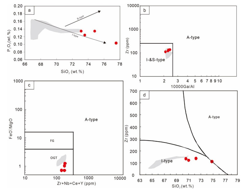
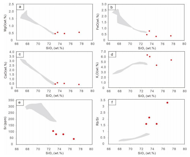
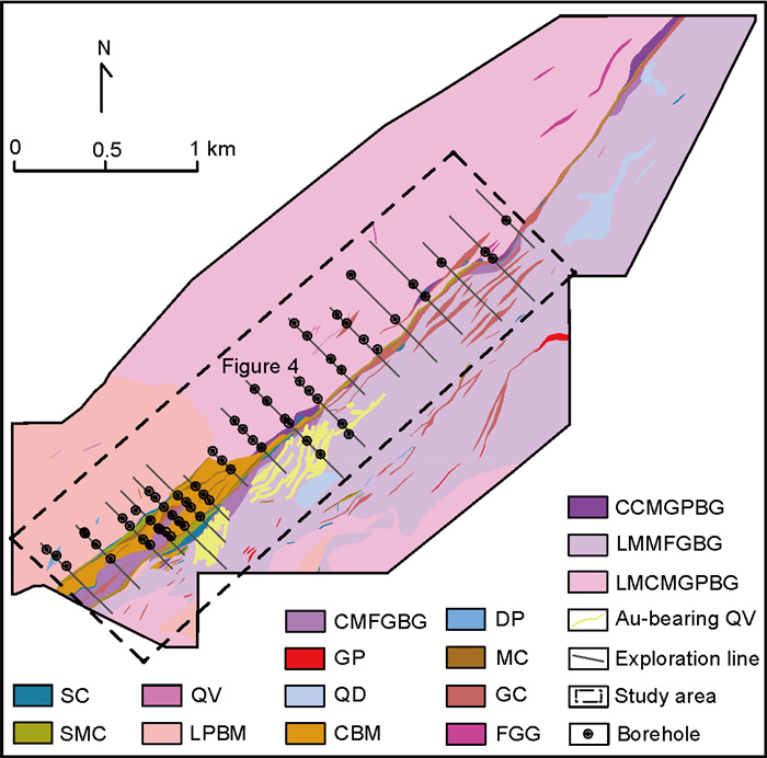
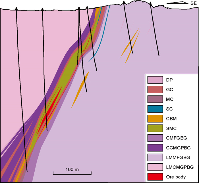
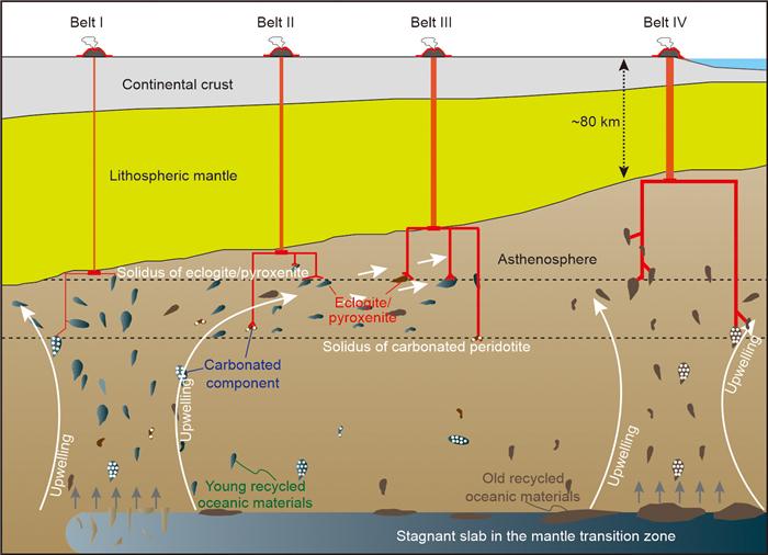
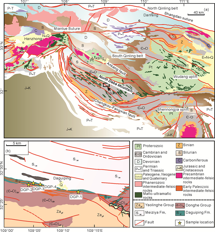
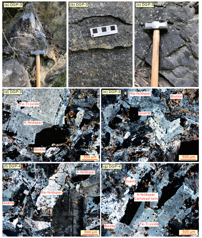
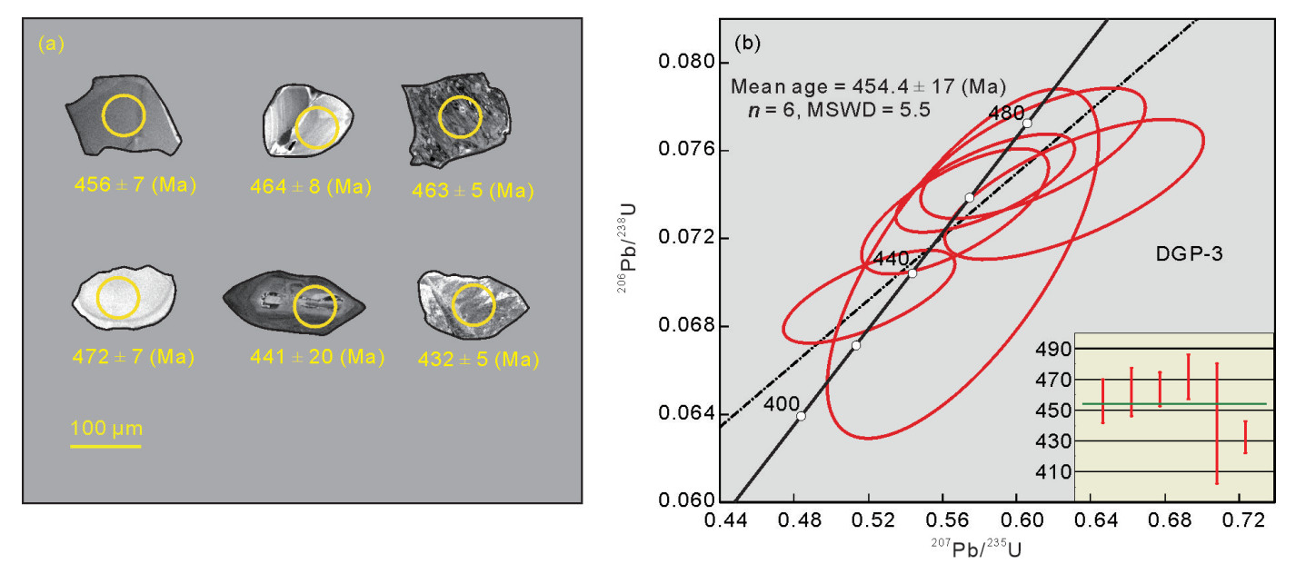
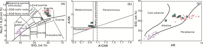
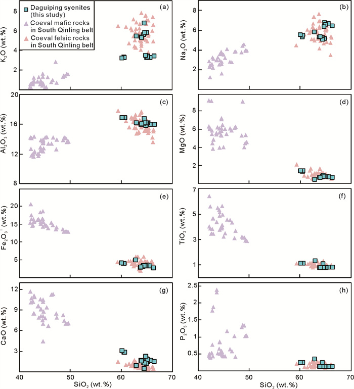
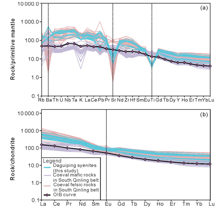
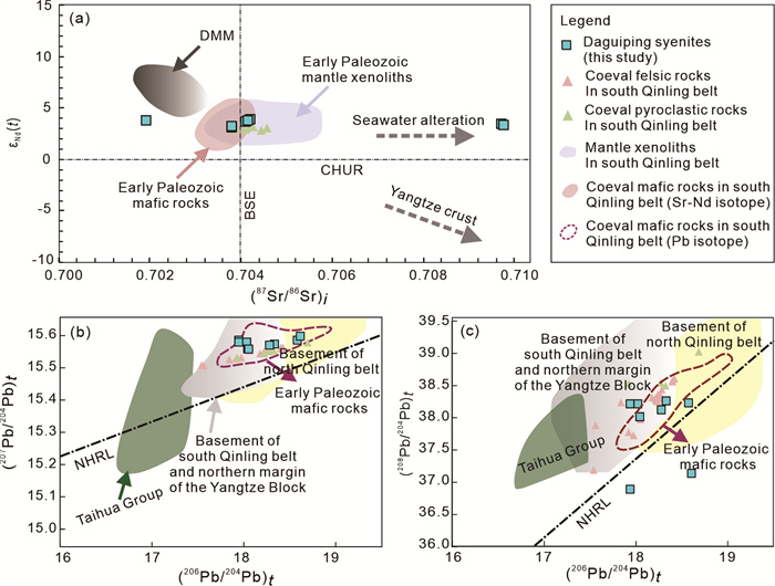
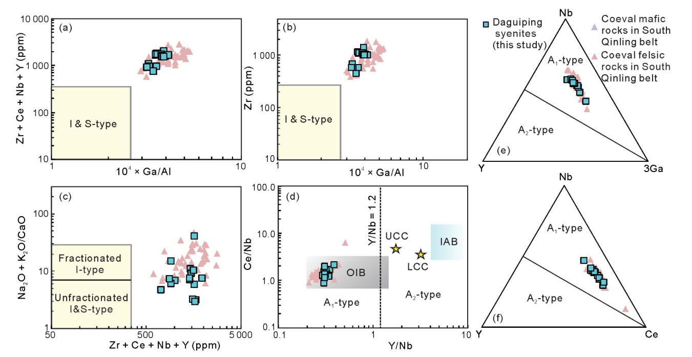
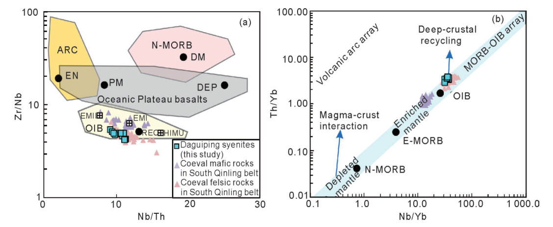
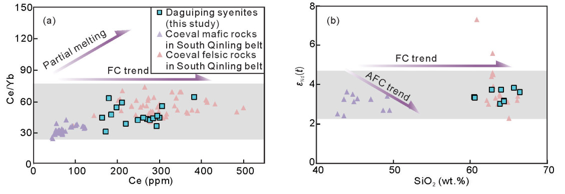
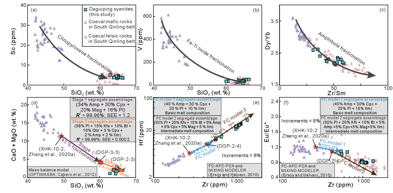
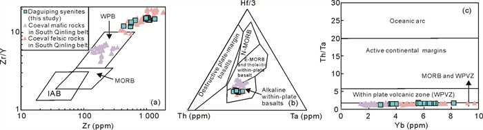
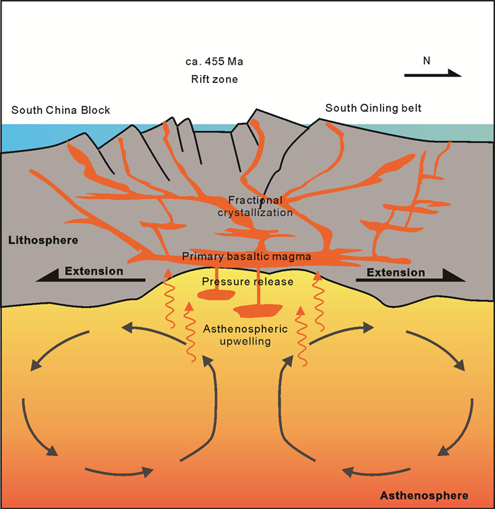
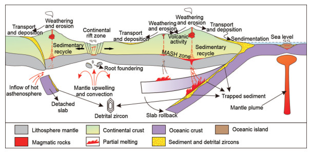
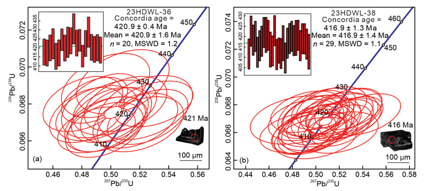
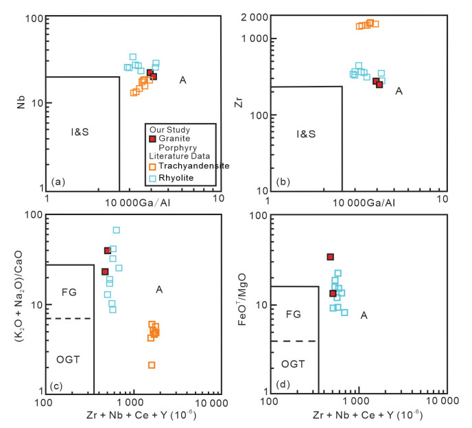
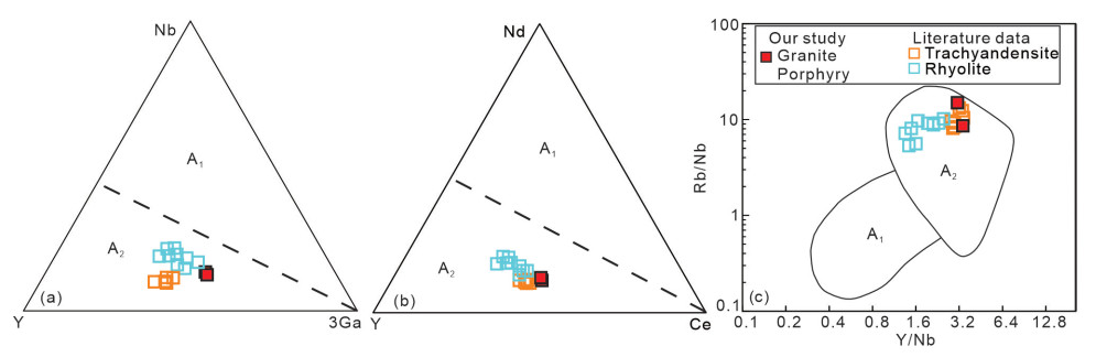
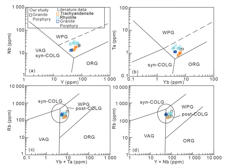
A-type rocks have drawn considerable attention in the past few decades due to their distinctive mineralogical and geochemical fingerprints and prospective utility for geodynamic reconstruction of the lithosphere. A comprehensive study, involving zircon U-Pb geochronology, whole-rock elemental and Sr-Nd-Pb isotopic geochemistry, was undertaken to elucidate the origin and evolutionary process for syenites from the Daguiping area in the North Daba mountains, South Qinling belt. The syenites revealed an Ordovician igneous crystallization age of 454.4 ± 17 Ma, coeval with the neighboring mafic rocks. All samples show high SiO2, LREEs, and HFSEs (Nb, Ta, Zr and Hf) contents, with negative to slightly positive Eu (Eu/Eu* = 0.78–1.08) anomalies. The geochemical characteristics of the Daguiping syenites imply that they are of A1-type magmatic affinity, which is confirmed by their high total alkali levels (8.57 wt.%–11.94 wt.%), Zr + Nb + Ce + Y contents (738.00 ppm–1 734.78 ppm), and 10 000 × Ga/Al ratios (3.25–4.22), as well as low Y/Nb ratios (0.30–0.40). Our samples exhibit a wide range of initial 87Sr/86Sr ratios of 0.701 943 to 0.709 802 and a narrow range of 143Nd/144Nd ratios of 0.512 205–0.512 246 with εNd(t) values from +3.0 to +3.8. These rocks display (206Pb/204Pb)initial, (207Pb/204Pb)initial, and (208Pb/204Pb)initial ratios range from 17.96 to 18.62, 15.55 to 15.59, and 36.87 to 38.22, respectively. All of the isotopic data indicate that the syenites were essentially mantle-derived. A cogenetic source for the Daguiping syenites and coeval mafic rocks in the South Qinling belt is supported by their uniform Sr-Nd-Pb isotope data and linear major/trace elemental changes, with prolonged fractional crystallization considered as the essential mechanism for these geochemical discrepancies. Mass-balance and Rayleigh fractionation modeling estimate ~85 vol% fractional crystallization involving amphibole, clinopyroxene, plagioclase, K-feldspar, biotite, Fe-Ti oxide, and quartz, to reproduce the compositional varieties between a coeval mafic rock and the Daguiping syenites. The Daguiping syenites and associated alkaline rocks were likely related to a rifting episode triggered by asthenospheric upwelling, which led to the South Qinling detaching from the South China Block along the Mianlue suture during the Early Paleozoic.

Geochemical Peculiarities and Genesis of Mud Volcanic Fluids Originated from Marine and Freshwater Strata: Insights from the North Tian Shan and the North Caucasus Mud Volcanoes
George Chelnokov, Li Zhang, Vasilii Lavrushin, Xiangxian Ma, Yuanyuan Shao, Yuxin Guo, Zhongping Li, Chunhui Cao, Huayun Tang, Guodong Zheng
2025, 36(5): 2208-2223. doi: 10.1007/s12583-025-0211-8
Abstract:

The phenomenon of mud volcanism has a connection with the processes of hydrocarbon generation. However, the genesis of sediments is not often taken into consideration. The study of mud volcanoes in the West Kuban marginal marine basin and the Junggar freshwater basin revealed significant isotope-geochemical differences due to various types of sedimentation. The waters from both basins exhibit three principal geochemical facies: Na-HCO3, Na-Cl-HCO3, and Na-Cl, of which the latter type of water is the dominant. The analysis of genetic coefficients (Cl/Br, Na/Br, and B/Cl) allowed us to distinguish different pathways of mud volcanic water evolution: evaporite dissolution, formation (sedimentation) waters, and waters formed by active water-rock interaction. Through statistical research, we were able to determine that noticeable variations in the behavior of chemical elements in waters from different areas can reflect discrepancies in the geological environment and the evolutionary stage of the diagenetic water transformation. Using thermodynamic modeling, the main directions of mass transfer were shown. It was established that the waters of the Junggar Basin were at a relatively early stage of evolution and had reached equilibrium only with carbonates, while in the formation waters of the West Kuban Basin, element concentrations were also controlled by silicate minerals. The correlations between δ18O and δ2H values and saturation indices of halides, aluminosilicates, sulfates, and borates confirm the enrichment of water with heavy isotopes during interactions with rocks without evaporation or thermal water partition. These reactions are characterized by clay dehydration and water enrichment with 18O and B. The data obtained made it possible to clarify the depths of formation of mud-volcanic fluids and their possible stratigraphic sources.

Complexity of the NWA 773 Clan: New Evidence from Lunar Olivine Gabbro NWA 6950
Qi He, Long Xiao, Ioannis Baziotis, Xiaochao Che, Yuqi Qian, Jiawei Zhao
2025, 36(5): 2224-2239. doi: 10.1007/s12583-023-1923-0
Abstract:

NWA 6950 is a type of cumulate gabbro meteorite that displays features indicating a lunar origin. Specifically, the Fe/Mn values of olivines and pyroxenes in the meteorite suggest a lunar origin, as does the presence of Fe-Ni metal. The meteorite has also undergone intense shock metamorphism, which is evidenced by the presence of ringwoodite, tuite, and xieite (a type of chromite with a CaTi2O4 structure) within the shock melt veins (SMVs). The texture, mineral modal abundances, and bulk compositions (measured from the SMVs) of NWA 6950 are similar to those of the NWA 773 clan, as are the concentrations and patterns of rare-earth-elements in olivine, pyroxene, plagioclase, and phosphate. In-situ U-Pb dating of baddeleyite and phosphate in NWA 6950 has determined its crystallization age to be 3 133 ± 11 and 3 129 ± 23 Ma, which is consistent with age data provided by Shaulis et al. (2017).Further, the chronology of the NWA 773 clan appears to be at least bimodal when considering the age of NWA 3333 (3 038 ± 20 Ma; Merle et al., 2020). The tight range of ages for the NWA 773 clan at approximately 3.1 Ga coincides with a change in the eruption flux and style on the Moon. This suggests that lunar volcanism may have shifted from extrusive-dominated to intrusive-dominated at approximately 3.1 Ga, resulting in the widespread distribution of gabbro lithologies on the Moon.

Hydrogeology and Environment Geology
Increased Anoxia Promotes Organic Carbon Mineralization in Surface Sediments of Saline Lakes
Pingping Zhang, Min Cai, Mingxian Han, Jibin Han, Xiying Zhang, Jian Yang, Hongchen Jiang
2025, 36(5): 2240-2250. doi: 10.1007/s12583-024-0155-4
Abstract:

Global warming and human activities have reduced the concentrations of dissolved oxygen in the bottom water of lakes, resulting in increased anoxia in surface sediments. This increased anoxia likely alters carbon cycling processes (e.g., organic carbon mineralization) by altering microbial community composition and functions in lakes. However, it remains unclear how organic carbon mineralization responds to increased anoxia in surface sediments of lakes (particularly saline lakes). In this study, CO2 production in surface sediments of six lakes with different salinity (0.47–250 g/L) on the Tibetan Plateau was investigated using microcosm incubations under aerobic and anaerobic conditions, respectively, followed by geochemical and microbial analyses. The results showed that for the freshwater lake, CO2 production rates in anaerobic sediment microcosms were significantly (P < 0.05) lower than their aerobic counterparts. In contrast, an opposite trend was observed for CO2 production in saline lakes. Furthermore, the CO2 production rates decreased significantly (P < 0.05) under aerobic conditions, while it exhibited a hump-like relationship with increasing salinity under anaerobic conditions. Taken together, our results suggest that increased anoxia would enhance organic carbon mineralization in surface sediments of saline lakes and help understand carbon feedback on global changes in saline lakes.

Sedimentary Evolution and Mangrove Dynamics in Dongzhai Harbor, Hainan Island since the Late Pleistocene
Xueyan Yan, Yamin Deng, Xianzhong Ke, Kang Peng, Xianjun Xie, Yiqun Gan, Qinghua Li
2025, 36(5): 2251-2265. doi: 10.1007/s12583-024-0089-x
Abstract:

Mangrove wetlands are a vital component of the blue carbon ecosystem, which is of great significance to coastal ecosystems and the global carbon balance. However, mangrove forests worldwide face a combination of natural and anthropogenic threats. This study employs high-resolution sedimentology, geochemistry, and pollen analysis to reveal the sedimentary evolution and vegetation succession in the mangrove wetland of Dongzhai Harbor, Hainan Island. By utilizing multiple proxies, including 14C chronology, δ13C, C/N, and the chemical index of alteration (CIA), we identified three distinct stages in the sedimentary records spanning from the Late Pleistocene to the modern age. Prior to the last glaciation, during the Late Pleistocene, the study area exhibited marine carbonate facies, with an abundance of marine-derived organic matter. During the low sea-level stage of the last glaciation, the strata in the core location were exposed. Following the last glaciation, the study area gradually transitioned into intertidal settings in response to fluctuating sea levels. Since the Middle Holocene or even earlier, sedimentary organic matter continued to accumulate as terrestrial C3 vegetation and mangrove forests established, persisted, and developed. This period witnessed the formation of the current estuarine environment. Simultaneously, the pioneering mangrove species, probably represented by Avicennia, might be initially established, followed by Rhizophora, Bruguiera and Ceriops communities, ultimately being replaced by Kandelia obovata to date. These findings not only fill the gap in the study of paleo-mangroves in China but also contribute valuable knowledge to the global reconstruction of paleo-mangroves, providing crucial reference for the conservation of mangroves and prediction of their responses in the context of climate change.

Impact of Phosphate Solubilizing Bacterial Agent on Cadmium Bioavailability and Microbial Communities in Soil and Cd Accumulation in Lettuce Plants
Yue Yu, Ping Li, Yanhong Wang, Xinzhe Lu, Chunlei Huang, Hanqin Yin
2025, 36(5): 2266-2278. doi: 10.1007/s12583-023-1852-0
Abstract:

Cadmium (Cd) contamination in soil can lead to food chain accumulation and greatly impacts on human health. Bioremediation has gained more and more attention due to its environment-friendly, high efficiency and low-cost. In this work, we studied the impact of phosphate solubilizing bacterial agent (PSBA) on Cd bioavailability, microbial communities in soil and Cd accumulation in lettuce plants with pot experiment and field trial. Results of pot experiment showed that PSBA could decrease the bioavailability of Cd (Cd-acid extractable from 3.30 to 2.34 mg/kg, Cd-reducible from 1.94 to 1.56 mg/kg), promote lettuce plants growth (increased by 33.85% height and by 33.65% fresh weight) and reduce the accumulation of Cd (from 5.85 to 3.73 mg/kg) in lettuce plants. High-throughput sequencing identified that PSBA could change the composition and structure of the soil microbial communities. The relative abundances of the three ecologically beneficial bacterial families of Pseudomonadaceae, Burkholderiaceae, and Enterobacteriaceae increased from 2.29% to 5.13%, 0.56% to 5.24%, and 1.87% to 16.93%, respectively. And the former two were positively correlated with redox potential (Eh) (R2 = 0.474, p < 0.05, R2 = 0.590, p < 0.01, respectively). The bacterial networks were more complex in PSBA treatment, reflecting through more links (from 1 893 to 2 185) and a higher average degree (from 38.242 to 45.052) and density (from 0.390 to 0.469). Results of field trial demonstrated that PSBA could also decrease Cd content in lettuce plants and microbial composition in soil. This study indicated that PSBA could be served as an alternative material in bioremediation of Cd contamination in soil.

Landscape Position and Shape as Drivers of Soil Properties and Quality Variation along Hillslope Sequences in a Semiarid Oak Forest
Javad Cheraghi, Mehdi Heydari, Mahmood Rostaminia, Reza Omidipour, Yahya Kooch, Daniel C. Dey
2025, 36(5): 2279-2295. doi: 10.1007/s12583-023-1938-6
Abstract:

Forest ecosystems can be characterized by a set of catenas arranged along the slope in mountainous areas as these affect microhabitat features, which in turn influence soil properties. Heretofore, few studies have examined how topographic variables affect soil properties and quality in semiarid regions. This study aimed to provide important insights into how catena position and shape influence soil properties, soil quality, and their interrelationships in a semiarid protected oak forest in western Iran. Basic soil properties were measured in the laboratory. In addition, the soil quality index (SQI) was calculated at different topographic positions along both convex (Λ-shaped) and concave (V-shaped) catenas at two soil depths (0–15 and 15–30 cm). The findings indicated that soil organic carbon and total nitrogen declined in the lower depth in both V- and Λ-shaped catenas and at all catena positions. The lowest porosity was observed in the lower depth at toeslope positions (TS) of both catenas. Substrate-induced respiration (SIR), microbial biomass carbon (MBC), and basal respiration (BR) were higher in the upper depths at TS positions on V-shaped catenas than on Λ-shaped catenas. These biological indices were consistently higher in the upper depths than in the lower depths across all positions of both catenas. SQI had the highest values at TS positions on both catenas and in the upper depths across all positions. Pearson correlations between soil properties indicated that SQI was most strongly and positively correlated with biological properties in both catenas. The nutrient levels, microbial activity, and soil porosity in both catena shapes and at both soil depths displayed a relatively downward trend with increasing elevation from toeslope to summit positions. The results showed that catena topographic sequence shape and position affected most of the soil properties, providing evidence of the important role of topography in creating pedodiversity in oak forest ecosystems.

Changes in China's Groundwater Storage with Natural and Anthropogenic Drivers
Xianghui Cao, Shaokang Yang, Yuejun Zheng, Qiuliang Lei, Jiaojiao Guan, Wenpeng Li, Kifayatullah Khan
2025, 36(5): 2296-2307. doi: 10.1007/s12583-024-0021-4
Abstract:

Groundwater is the major source of fresh water, and it performs a crucial role in maintaining ecosystems and adapting humans to climate variation. Due to excessive reliance on groundwater in some regions, the amount of groundwater being consumed is higher than the recharge, which leads to a durative decline of groundwater level. This study analyzed the spatiotemporal variability in groundwater storage (GWS) in China. And the possible drivers of observed GWS changes were also identified. GWS level displayed large regional disparities with higher reserves in the Yangtze River Basin and Songhua River Basin. Temporally, GWS level showed decreasing trends in the North China Plain region, Yellow River Basin, Inner Mongolia Plateau and Junggar Basin. And, GWS showed a significant increase in the Tibetan Plateau and Songhua River Basin. Without considering the impact of human activities, groundwater reserves are also showing a decreasing trend in future climate scenarios in most of the 15 zones. Contribution analysis of driving forces on the basis of the percentages of standardized coefficient (r) suggested that the variations of GWS were largely controlled by anthropogenic activities with the contribution proportions of 35.43%–73.37%. And the contribution proportions of natural drivers accounted for 26.63%–64.62%, with the key factors of precipitation, temperature and vegetation cover. The results would help to formulate sustainable strategies for managing groundwater resource.

Big Data Geosciences
Co-Evolution of Magmatic and Sedimentary Fluxes Coupling with Supercontinents: Insight from Singularity Analysis of Deep-Time Geological Records
Molei Zhao, Guoxiong Chen, Jie Yang, Yuanzhi Zhou, Qiuming Cheng
2025, 36(5): 2308-2316. doi: 10.1007/s12583-022-1796-9
Abstract:

Continental crust is the long-term achievements of Earth's evolution across billions of years. The continental rocks could have been modified by various types of geological processes, such as metamorphism, weathering, and reworking. Therefore, physical or chemical properties of rocks through time record the composite effects of geological, biological, hydrological, and climatological processes. Temporal variations in these time series datasets could provide important clues for understanding the co-evolution of different layers on Earth. However, deciphering Earth's evolution in deep time is challenged by incompleteness, singularity, and intermittence of geological records associated with extreme geological events, hindering a rigorous assessment of the underlying coupling mechanisms. Here, we applied the recently developed local singularity analysis and wavelet analysis method to deep-time U-Pb age spectra and sedimentary abundance record across the past 3.5 Gyrs. Standard cross-correlation analysis suggests that the singularity records of marine sediment accumulations and magmatism intensity at continental margin are correlated negatively (R2 = 0.8), with a delay of ~100 Myr. Specifically, wavelet coherence analysis suggests a ~500‒800 Myr cycle of correlation between two records, implying a coupling between the major downward processes (subduction and recycling sediments) and upward processes (magmatic events) related to the aggregation and segregation of supercontinents. The results clearly reveal the long-term cyclic feedback mechanism between sediment accumulation and magmatism intensity through aggregation of supercontinents.

Spatially Constrained Variational Autoencoder for Geochemical Data Denoising and Uncertainty Quantification
Dazheng Huang, Renguang Zuo, Jian Wang, Raimon Tolosana-Delgado
2025, 36(5): 2317-2336. doi: 10.1007/s12583-025-0180-y
Abstract:

Geochemical survey data are essential across Earth Science disciplines but are often affected by noise, which can obscure important geological signals and compromise subsequent prediction and interpretation. Quantifying prediction uncertainty is hence crucial for robust geoscientific decision-making. This study proposes a novel deep learning framework, the Spatially Constrained Variational Autoencoder (SC-VAE), for denoising geochemical survey data with integrated uncertainty quantification. The SC-VAE incorporates spatial regularization, which enforces spatial coherence by modeling inter-sample relationships directly within the latent space. The performance of the SC-VAE was systematically evaluated against a standard Variational Autoencoder (VAE) using geochemical data from the gold polymetallic district in the northwestern part of Sichuan Province, China. Both models were optimized using Bayesian optimization, with objective functions specifically designed to maintain essential geostatistical characteristics. Evaluation metrics include variogram analysis, quantitative measures of spatial interpolation accuracy, visual assessment of denoised maps, and statistical analysis of data distributions, as well as decomposition of uncertainties. Results show that the SC-VAE achieves superior noise suppression and better preservation of spatial structure compared to the standard VAE, as demonstrated by a significant reduction in the variogram nugget effect and an increased partial sill. The SC-VAE produces denoised maps with clearer anomaly delineation and more regularized data distributions, effectively mitigating outliers and reducing kurtosis. Additionally, it delivers improved interpolation accuracy and spatially explicit uncertainty estimates, facilitating more reliable and interpretable assessments of prediction confidence. The SC-VAE framework thus provides a robust, geostatistically informed solution for enhancing the quality and interpretability of geochemical data, with broad applicability in mineral exploration, environmental geochemistry, and other Earth Science domains.

Editorials
Changbaishan Volcanism: Is Seamount Subduction the Missing Piece?
Xiaobo He, Mingli He, Yibing Li, Jiashun Hu, Fabin Pan, Zhensheng Wang, Jianshe Lei
2025, 36(5): 2337-2340. doi: 10.1007/s12583-025-0181-x
Abstract:
Influence of Particle Size Distribution on Shear Behavior of Weak Interlayers: Insights from Filled Fractures Shear Tests
Jiajun Ji, Changdong Li, Cheng Dong, Wenqiang Chen, Bingchen Li
2025, 36(5): 2341-2347. doi: 10.1007/s12583-025-0182-9
Abstract:
Pressure-Stress Coupling: Connotation and Denotation
Dong Yang, Shang Xu, Fang Hao, Bingchang Liu, Bo Gao, Yunxuan Guo, Jingheng Nie
2025, 36(5): 2348-2352. doi: 10.1007/s12583-025-0185-6
Abstract:
Genesis of the Debao Sn-Cu Deposit in South China: Insights from Pb-S-He-Ar Isotopes
Jian Zhang, Lichuan Zhang, Quan Ou, Pan Qu, Yinqiao Zou, Hongxia Yu
2025, 36(5): 2353-2358. doi: 10.1007/s12583-025-0184-7
Abstract:
A Submillimeter Iron Particle in Chang'e-6 Lunar Soil
Zhi Cao, Zhiyong Xiao, Yunhua Wu, Pan Yan, Yanxue Wu, Zongjun Ying, Zilei Chen, Suping Wu
2025, 36(5): 2359-2364. doi: 10.1007/s12583-025-0183-8
Abstract:
Discovery and Significance of Paleozoic Granite Porphyry in the Haidewula Uranium Deposit, East Kunlun Orogenic Belt, Northwest China
Jian-Hua Duan, Tong Liu, Jia-Wen Dai, Hui-Min Su, Yan-Qiang Li, Shao-Yong Jiang
2025, 36(5): 2365-2372. doi: 10.1007/s12583-025-0186-5
Abstract:
Formation Mechanisms and Distribution Patterns of Fractures in Shale Reservoirs: A Case Study of the Lucaogou Formation, Jimsar Sag, Junggar Basin
Xiangye Kong, Xingjian Wang, Zhiwu Li, Peng Zhu, Yixin Dong, Qun Luo, Zhiqi Zhong, Zhanbo Liu, Jie Tan
2025, 36(5): 2373-2379. doi: 10.1007/s12583-025-0188-3
Abstract:
Rapid Post-Earthquake Impact and Recovery Assessment: The 2025 Mw 7.7 Myanmar Earthquake
Wenkai Chen, Jiajie Wu, Gang Rao, Xue Li, Lize Chen, Yuyang Peng, Zhenhang Zhang, Ming Yi, Yanping Sun
2025, 36(5): 2380-2386. doi: 10.1007/s12583-025-0187-4
Abstract: