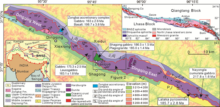
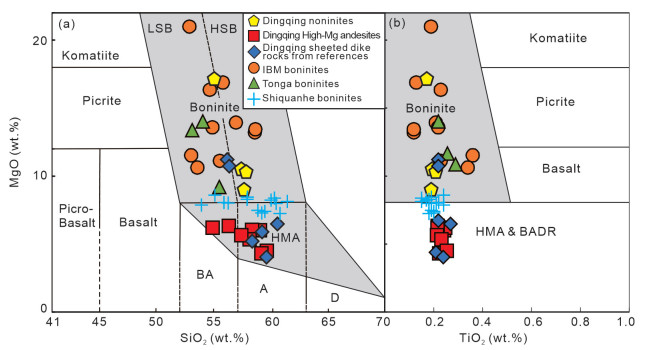
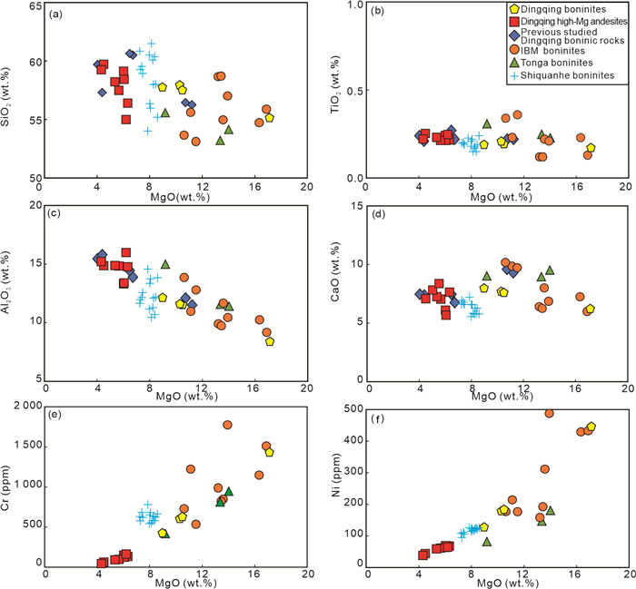
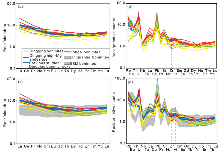
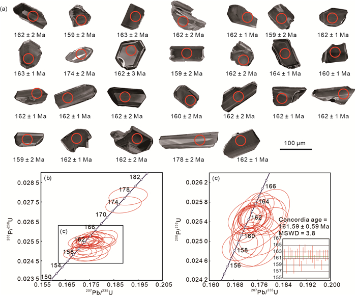
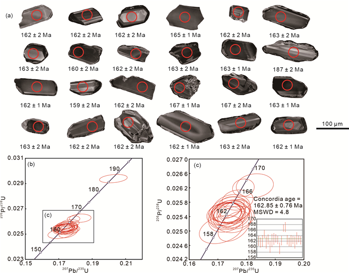
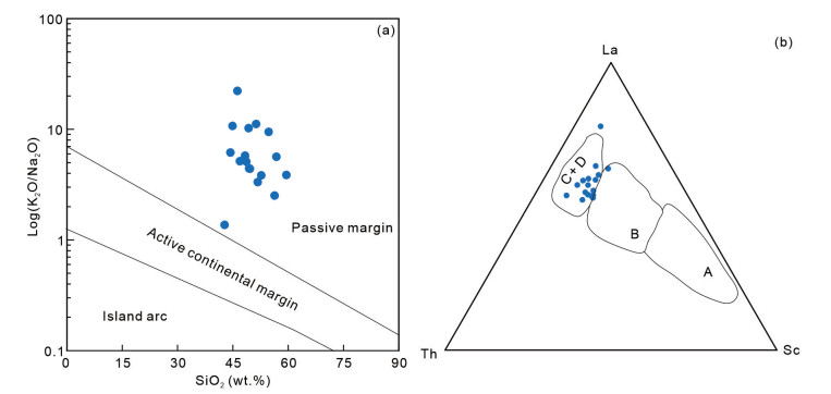
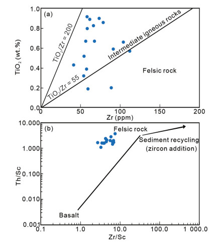
The Dingqing ophiolite in the eastern segment of the Bangong-Nujiang suture zone records multiple episodes of magmatic events, providing crucial constraints on the tectonic evolution of the Meso-Tethyan Ocean. We focus on sheet dikes recently discovered during the geological survey of 1 : 50 000 scale mapping the Dingqing East ophiolite. The studied samples are categorized into two types of high-Ca boninite and high-Mg andesite. Two high-Mg andesite samples yield
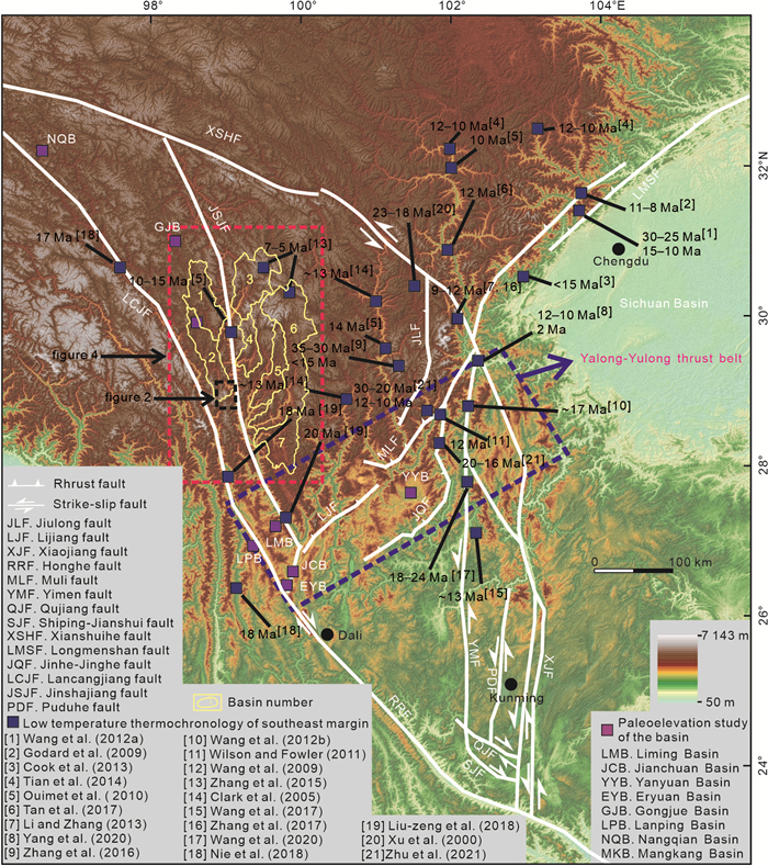
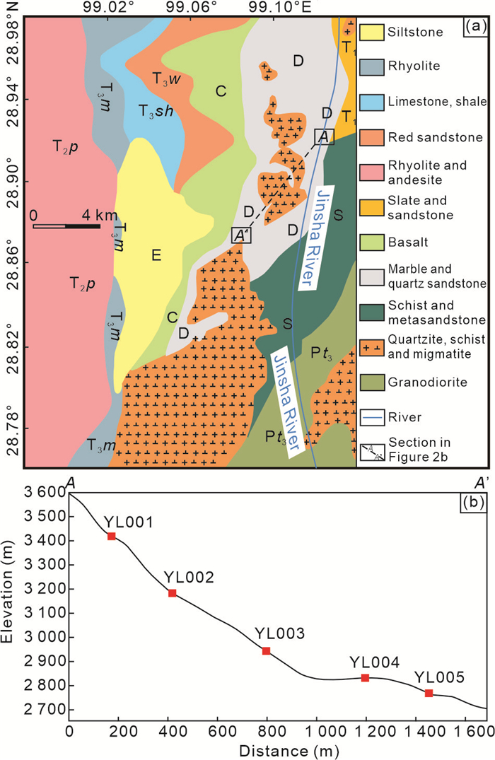
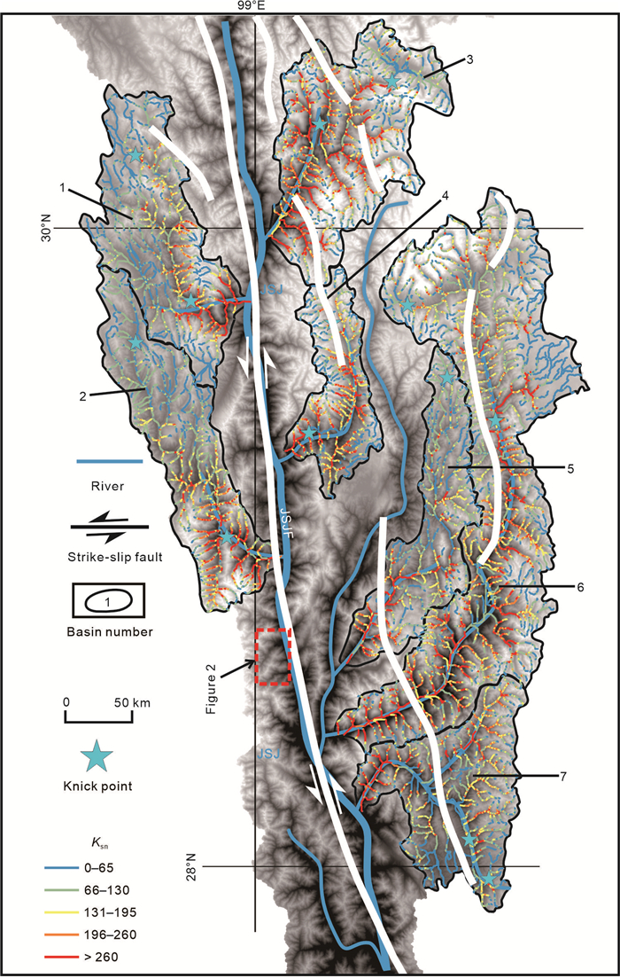
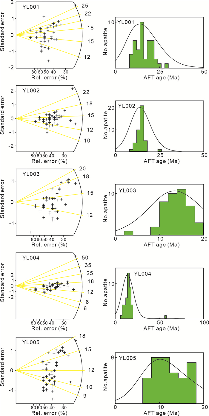
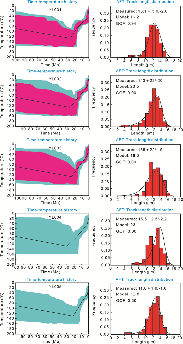
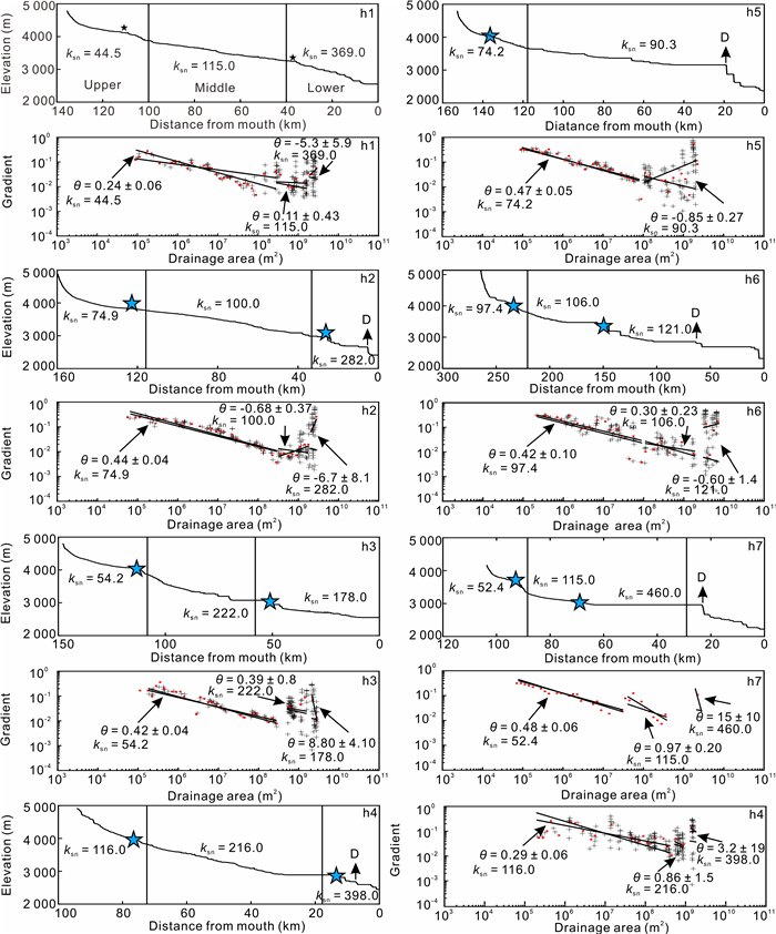
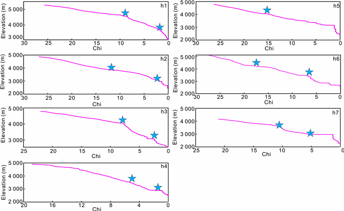
The initial timing of uplift at the southeastern margin of the Tibetan Plateau (SMTP) remains under debate, with estimates ranging from the Eocene, to the Oligocene. The Jinsha River was formed before the Miocene, therefore, it is likely to record the uplift information of the Tibetan Plateau, which is important for understanding the tectonic uplift of the SMTP. Here, we collected granite samples from the Yangla area in the middle part of the Jinsha River, and analyzed the uplift characteristics of the Cenozoic in the middle part of the Jinsha River by using the apatite fission tracks and the river longitudinal profiles. We show that the uplift time of the first phase is about 25–20 Ma, and the uplift time of the second phase is about 5 Ma. From the channel profile, seven tributaries of the Jinsha Rivers also have developed two phases of knickpoints. The tributaries consist of three sections with distinct geomorphological parameters, each separated by knickpoints. We argue that large-scale uplift occurred in the Late Cenozoic on the SMTP, with different locations having different uplift times, and the interior may have undergone significant uplift in the early Oligocene, but significant uplift of the SMTP occurred by the Late Oligocene to Early Miocene. The Jinsha River flowing from the interior of the plateau has developed multiple knick points during the uplift process, recording information about the uplift of the Tibetan Plateau.

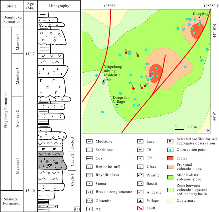
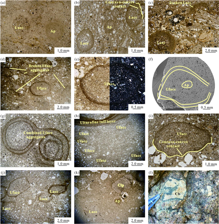
The ash aggregates occur in the pyroclastic rocks of Early Cretaceous Yingcheng Formation, which are outcropped in the southeastern margin of the Songliao Basin, China. We focus on the types and genesis of the ash aggregates. Five types of ash aggregates are identified, including ash pellets (Ap), layered accretionary lapilli (Lacc), ultrafine rim-type accretionary lapilli (Ufacc), coated lava particle (Clp), and coated breccia (Cb), and there are six types of lithofacies related to ash aggregate accumulation: (1) Ap and Lacc bearing fine tuff with hummocky-parallel bedding, (2) Ufacc bearing fine tuff with hummocky-parallel bedding, (3) Lacc and Ufacc bearing fine tuff with hummocky-parallel bedding, (4) Ap, Clp, Lacc, and Ufacc bearing medium-fine tuff with graded and parallel bedding, (5) Lacc and Cb bearing lapilli-ash tuff with massive-graded bedding, and (6) Cb bearing lapilli tuff with massive-welded structure. Base surges, pyroclastic flows, and ash falls contribute to the ash aggregation, especially ash falls. Our study of the ash aggregate accumulation relative to the lithofacies and their spatial distribution is helpful to reconstruct the paleo-volcano edifice, distinguish the ash fall deposits from the pyroclastic flow/surge deposits and infer wind direction during the time of volcanic activity in the research area.


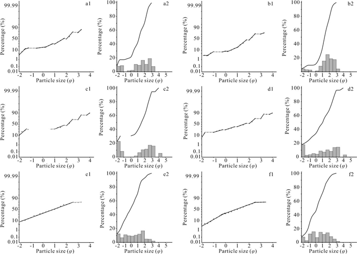

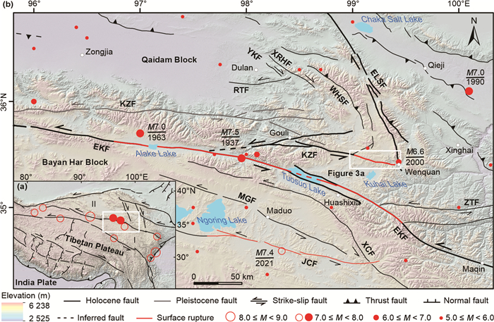
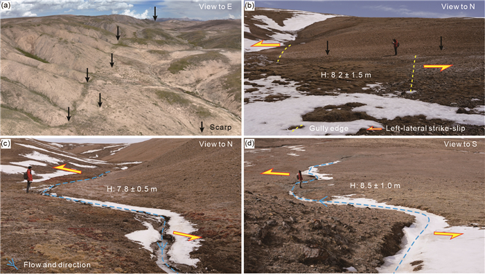
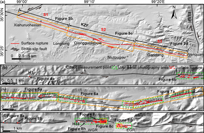
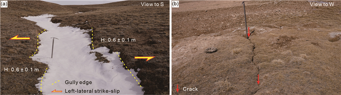
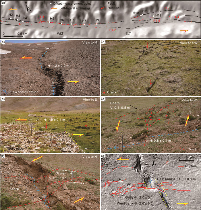
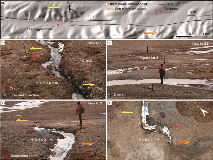
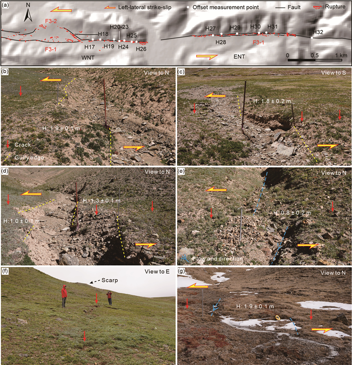
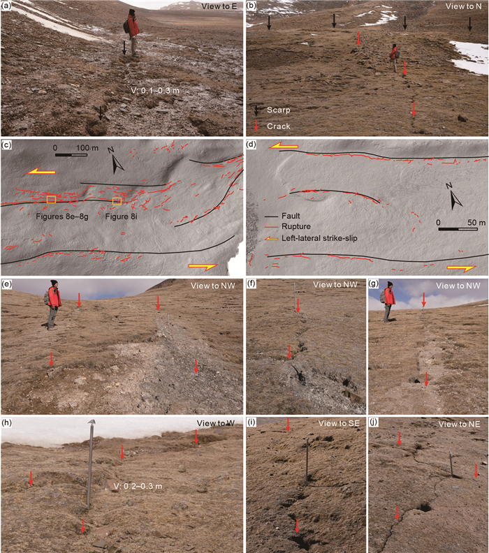
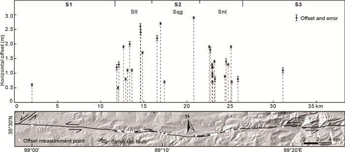
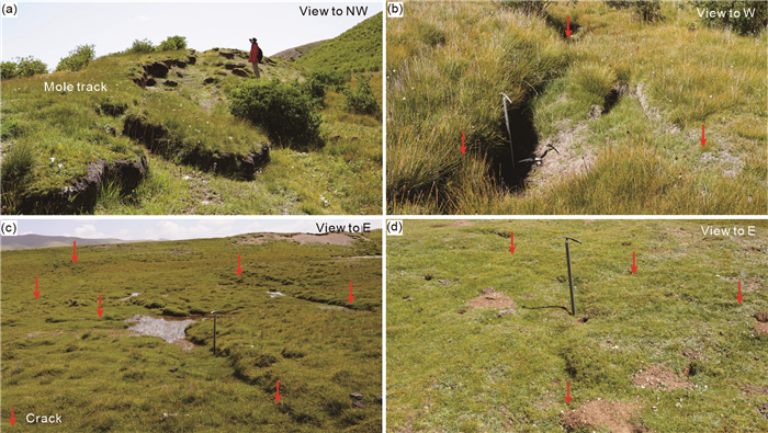
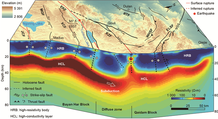
The Tibetan Plateau is one of the regions with the most active neotectonic movement and frequent seismic activity in the world. The Bayan Har Block, located in the Northern Tibetan Plateau, has been the main area for clusters of major earthquakes with
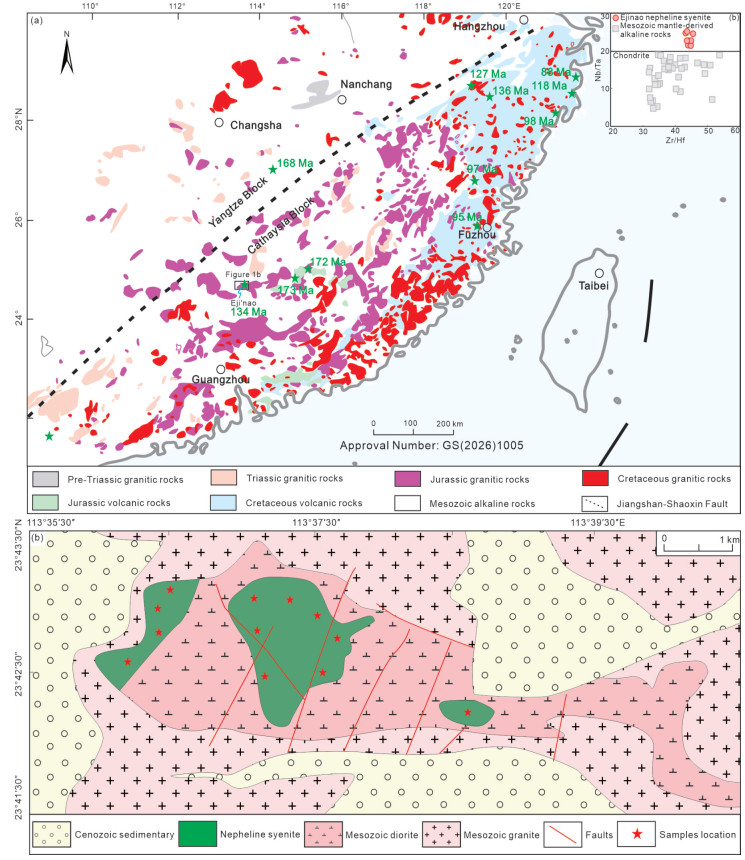
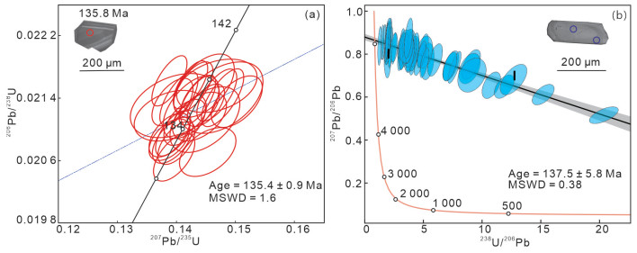
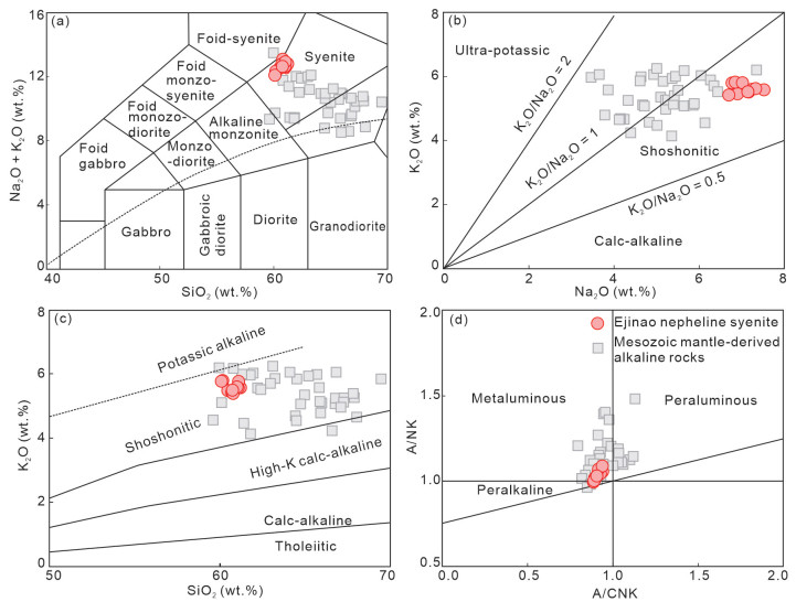
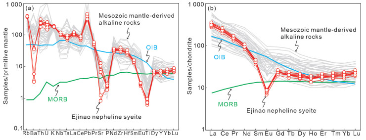
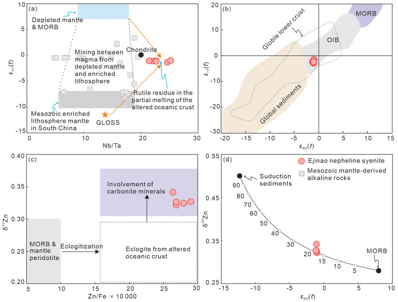
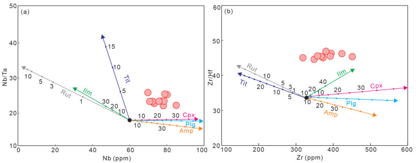
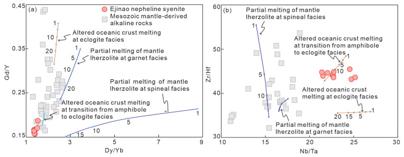
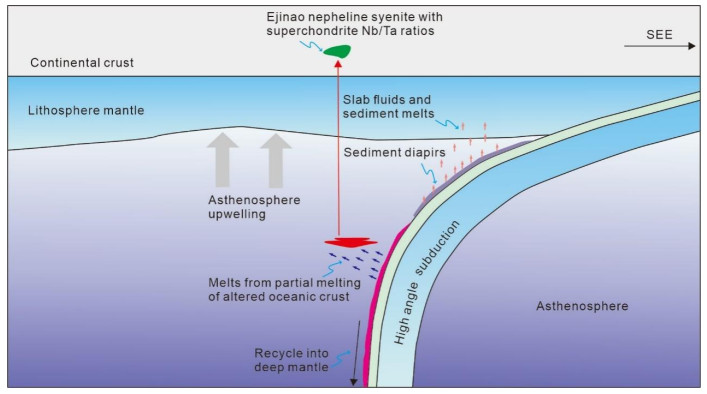
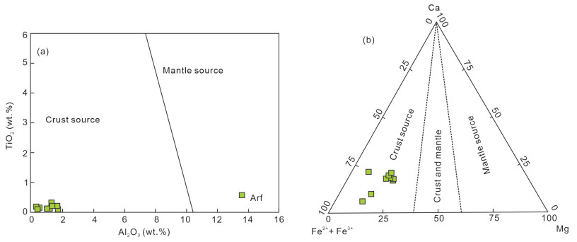
The cause resulting in alkaline rocks with superchondritic Nb/Ta ratios remains a geochemical enigma. This paper presents zircon and apatite geochronology, mineralogy, geochemistry, and Nd-Hf-Zn isotope investigation on the Ejinao nepheline syenite from South China to constrain the petrogenesis of alkaline rocks. The occurrence of alkaline minerals, including alkaline feldspar, arfvedsonite, and nepheline, indicate an alkaline feature of the Ejinao nepheline syenite. Zircon and apatite from the rock show U-Pb concordia age of 135.4 ± 0.9 and 137.5 ± 5.8 Ma, respectively, suggesting generation in the Early Cretaceous. The rock is characterized by low MgO (0.17 wt.%–0.26 wt.%) contents, but high Fe2O3T (4.66 wt.%–6.16 wt.%) and total alkalis (Na2O + K2O = 12.1 wt.%–13.1 wt.%) contents, consistent with the melts from subducting oceanic crust rather than mantle peridotite. The rock has low TiO2 (0.13 wt.%–0.21 wt.%) contents and superchondritic Nb/Ta and Zr/Hf ratios, resulting from rutile residue in the source area. The
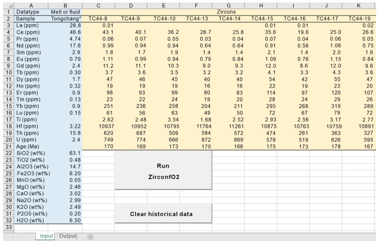
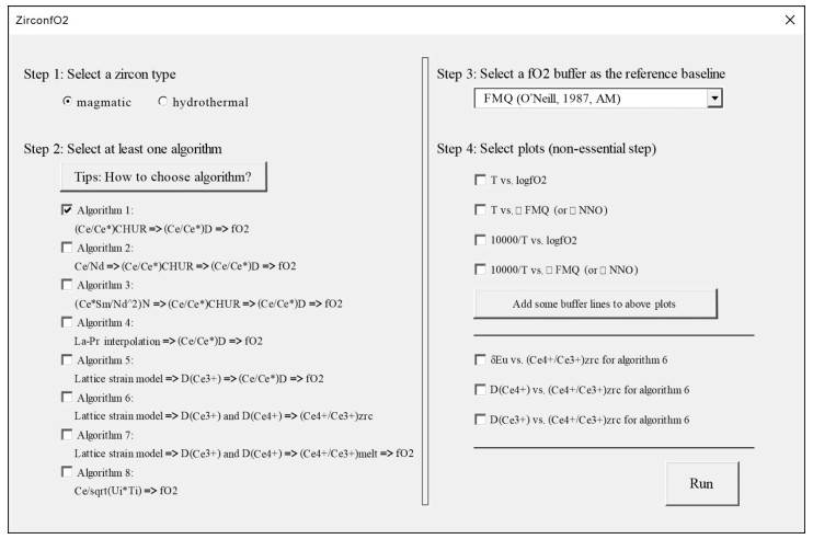
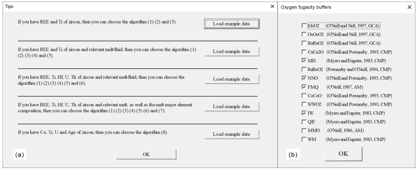
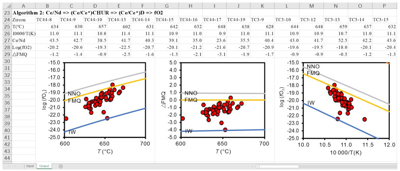
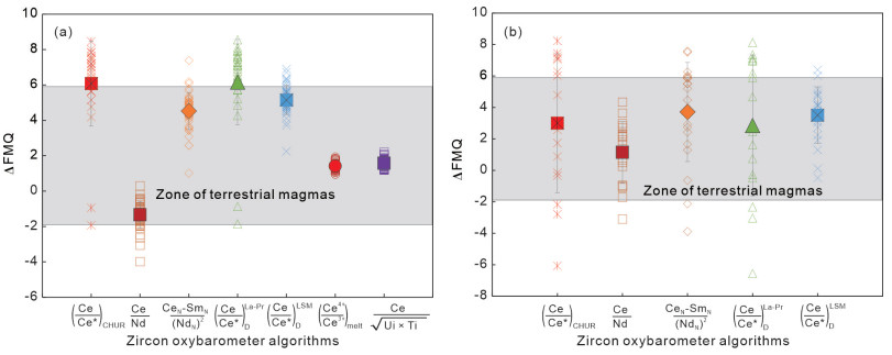
Oxygen fugacity of magmas and hydrothermal fluids is an important factor affecting element migration and mineralization. Zircon is an excellent monitor for oxygen fugacity of melts and fluids due to its exceptionally stable nature. However, zircon oxybarometers involve many complex algorithms leading to difficulties in use. Therefore, there is an urgent need to realize automatic calculation of various zircon oxybarometers. This study developed a Visual Basic for Applications (VBA) program, ZirconfO2, built in an ExcelTM workbook, for calculating the oxygen fugacity of magmatic and hydrothermal fluids through the trace element characteristics of zircons. The program covers almost all the algorithms of zircon oxybarometers commonly-used so far. Through the user-friendly interface, users may input data expediently, obtain multiple results of various algorithms and find the most reliable oxygen fugacity range, effectively avoiding the possible misdirection of a single algorithm.
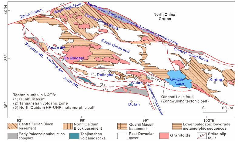
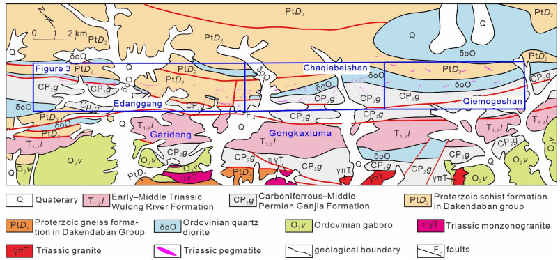
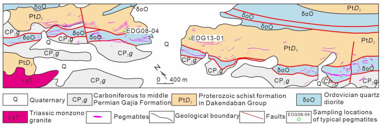
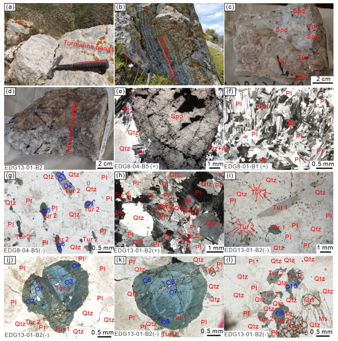
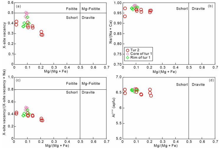
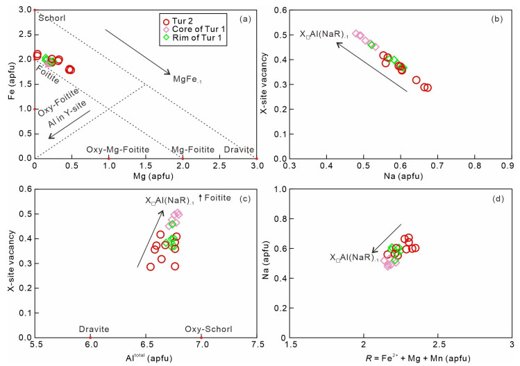
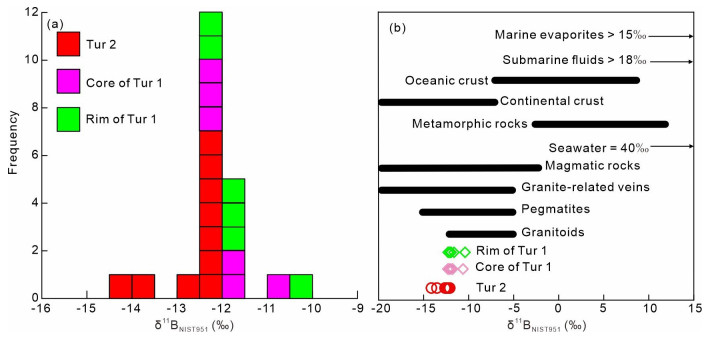
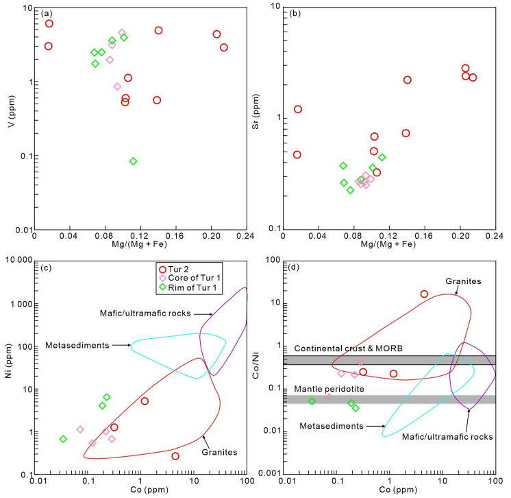
The Edanggang area is characterized by small-scale Li-Be-bearing granitic pegmatites in the Quanji Massif, northwest China. The genesis of these Li-Be-bearing pegmatites remains unresolved. In this study, we use tourmalines as an indicator to constrain the genesis of them.


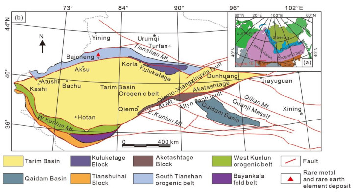
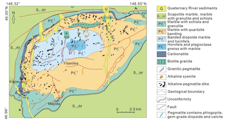
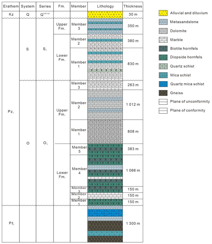
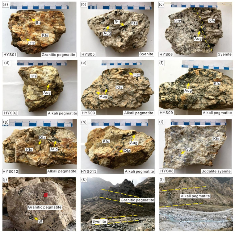
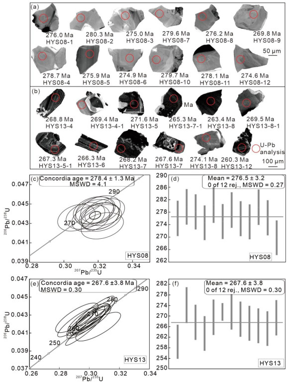
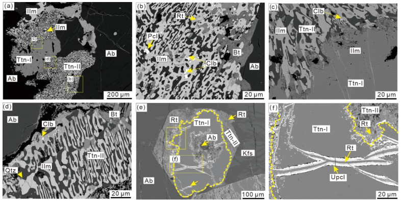
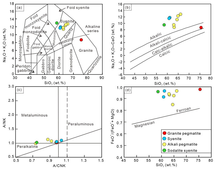
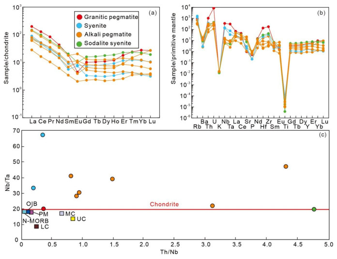
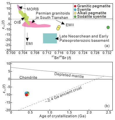
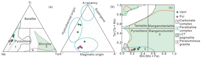
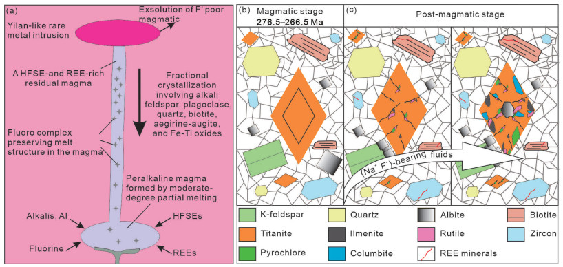
Despite extensive studies on Nb deposits associated with alkaline rocks, the key factors controlling Nb enrichment remain uncertain, with conditions varying across distinct alkaline intrusions. To better understand Nb mineralization in alkaline rocks, we conducted an integrated investigation of samples from an Nb-bearing peralkaline-alkaline intrusion in the Yilan-like region of the northern Tarim Basin. The Yilan-like intrusion is predominatly composed of granitic pegmatite, alkali pegmatite, syenite, and sodalite syenite. Zircon dating results reveal that this intrusion was emplaced at about 276 Ma. The Yilan-like intrusion is characterized by high SiO2 and total alkali contents and prominent enrichment of HFSE and LREE, with obvious depletions of Ba, K, P, and Ti. The peralkaline-alkaline rocks have high initial 87Sr/86Sr ratios (0.715 8 to 0.853 3) and negative


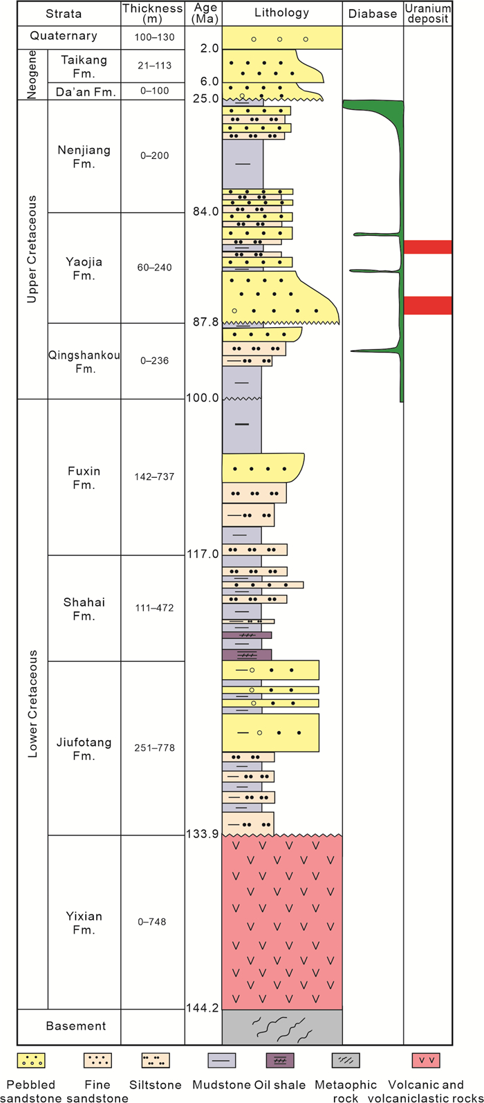
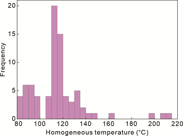
The metallogenic age of sandstone-type uranium deposits has always been a scientific problem to be solved in uranium exploration. This paper proposes a method combining the homogenization temperature of secondary fluid inclusions with the apatite (U-Th)/He dating method to determine the metallogenic age related to fluid trapping. The dates of apatite (U-Th)/He can be used as the lower limit of the metallogenic age when the closure temperature of apatite (U-Th)/He is less than the homogenization temperature of the secondary fluid. The samples of the uranium deposits in the Qianjiadian sag show that the homogenization temperatures of secondary fluid inclusions in the ore-bearing horizon are about 83–204 ℃ with a peak of 110–115 ℃, and the apatite (U-Th)/He dates in the same horizon vary between 29.0 ± 1.5–41.8 ± 2.7 Ma. Because the homogenization temperatures of secondary fluid are greater than the closure temperature of apatite (U-Th)/He (75 ± 5 ℃), the dates of apatite (U-Th)/He (29.0 ± 1.5–41.8 ± 2.7 Ma) are considered as the lower limit of the metallogenic age.

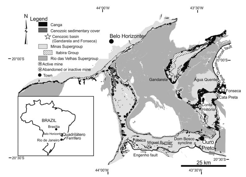
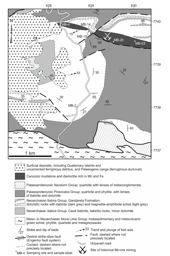
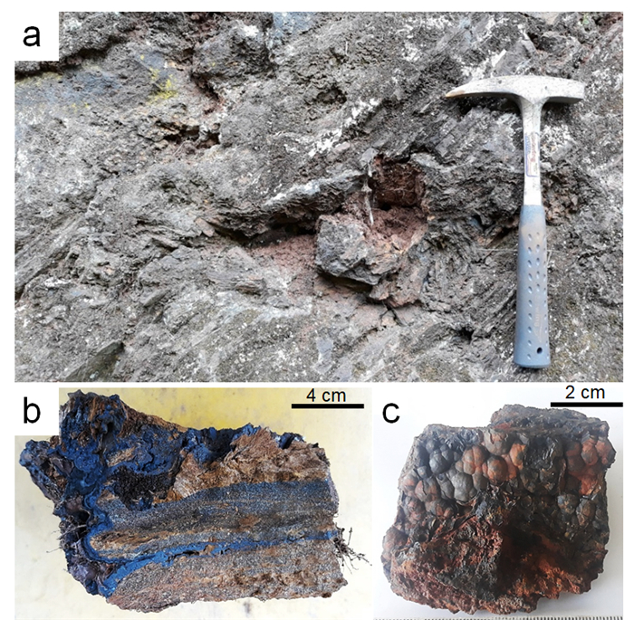
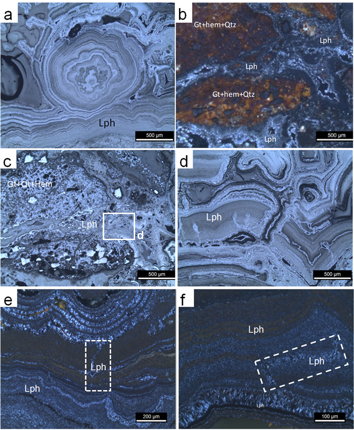
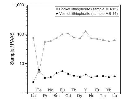
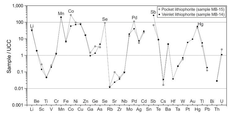
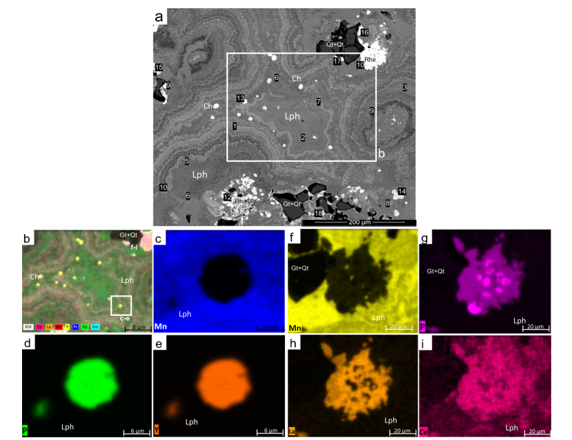
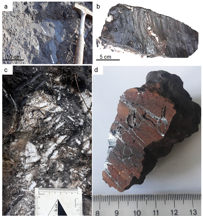
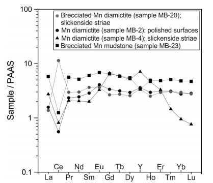
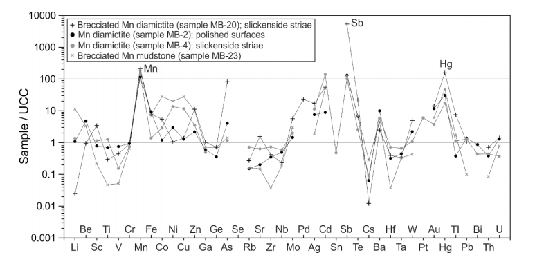
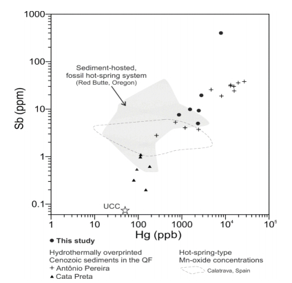
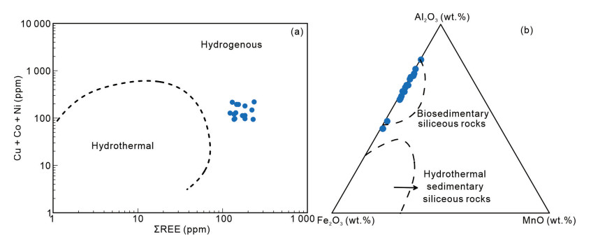
The Miguel Burnier manganese (Mn)-ore deposit, located in the Quadrilátero Ferrífero of Minas Gerais, Brazil, has enrichments in the rare-earth elements (REE). Here, this finding is reported. Three types of REE enrichments have been identified in: (1) Cenozoic wad-like diamictite; (2) hydrothermally altered manganiferous mudstone of Cenozoic age; (3) lithiophorite-rich veinlets and pockets within Precambrian itabirite. In the latter, churchite-(Y) [Y(PO4)·2H2O] and rhabdophane-(La) [La(PO4)·H2O] are the main REE-bearing minerals. Other metals, in particular mercury (Hg), are also enriched, indicating that metalliferous overprint took place during the Cenozoic in a tectonically stable, cratonic terrane.
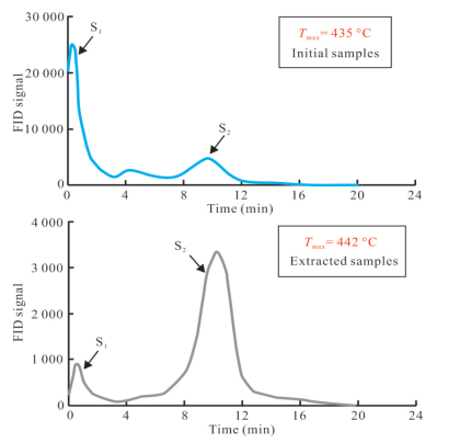
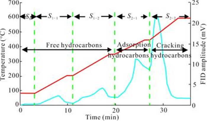
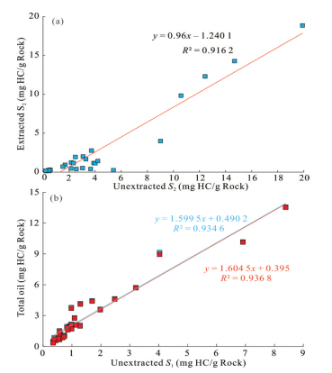
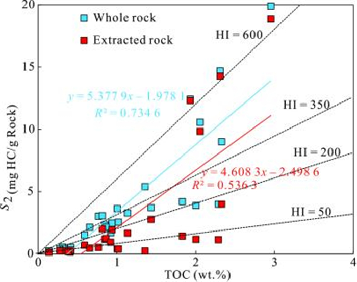
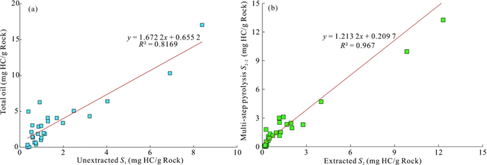
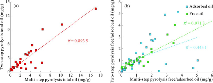
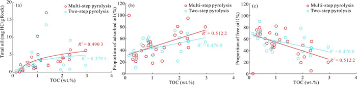
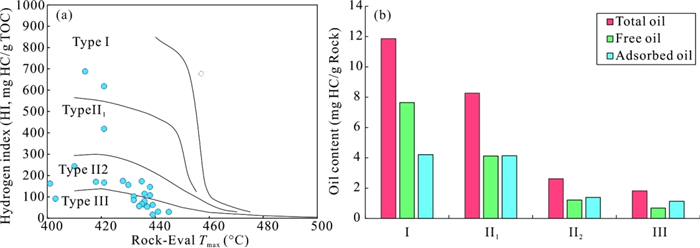
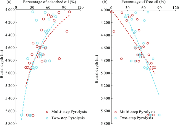
This research has investigated the oil content of lacustrine shale-oil systems from the Junggar Basin. Twenty-eight samples are used for different pyrolysis experiments to study the characteristics of shale oil occurrence and the difference between various evaluation methods. Additionally, the factors affecting the physical states of shale oil are discussed. Compared with the standard Rock-Eval, the two-step pyrolysis and multi-step pyrolysis can eliminate the influence of the carryover effect. Therefore, these two types of pyrolysis are used to obtain the total, free, and adsorbed oil yield of the shale. The results demonstrate that the total oil yield acquired by multi-step pyrolysis is quite similar to that obtained by two-step pyrolysis. Both of them can prevent the retained oil yield from being underestimated by more than 50%. However, the free oil yield obtained by multi-step pyrolysis is significantly higher than that obtained by two-step pyrolysis. The multi-step pyrolysis can easily exaggerate the real free oil yield in resource evaluation. Therefore, this article suggests using the two-step pyrolysis to eva-luate the characteristics of petroleum in shales. Furthermore, the amount of hydrocarbons within shales is related to organic matter properties. The higher the organic matter richness, the higher the total/adsorbed oil yield within the shale before reaching the adsorption saturation. The better the kerogen type, the higher the amount of liquid hydrocarbons within shales. As the thermal evolution of shales increases, the free oil proportion and the mobility of petroleum increase. This study compared different pyrolysis methods, which provided new insight for obtaining the oil content of shales, a key parameter of shale oil resource evaluation.
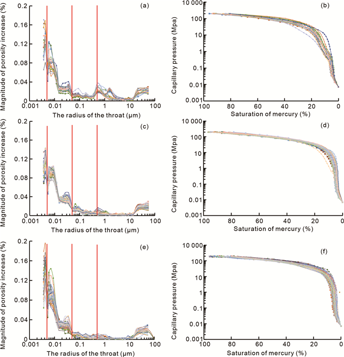
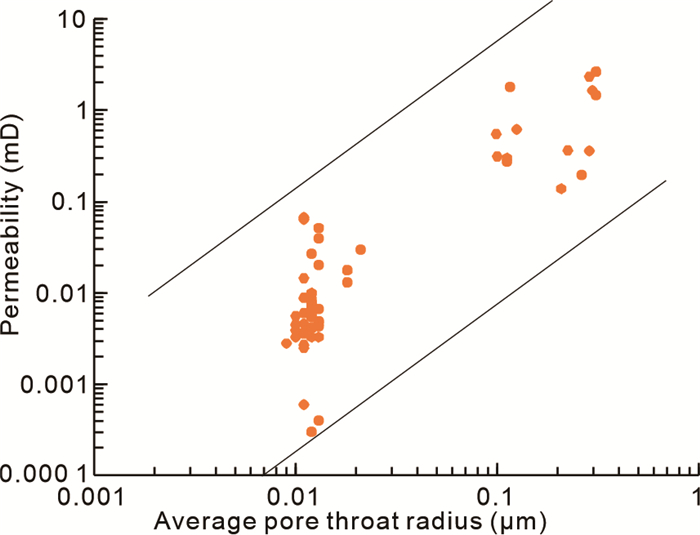
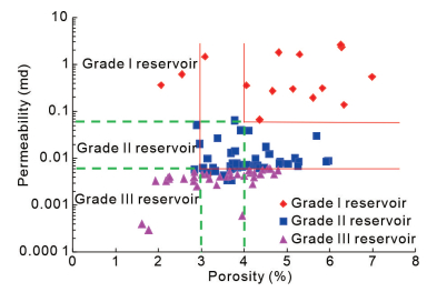
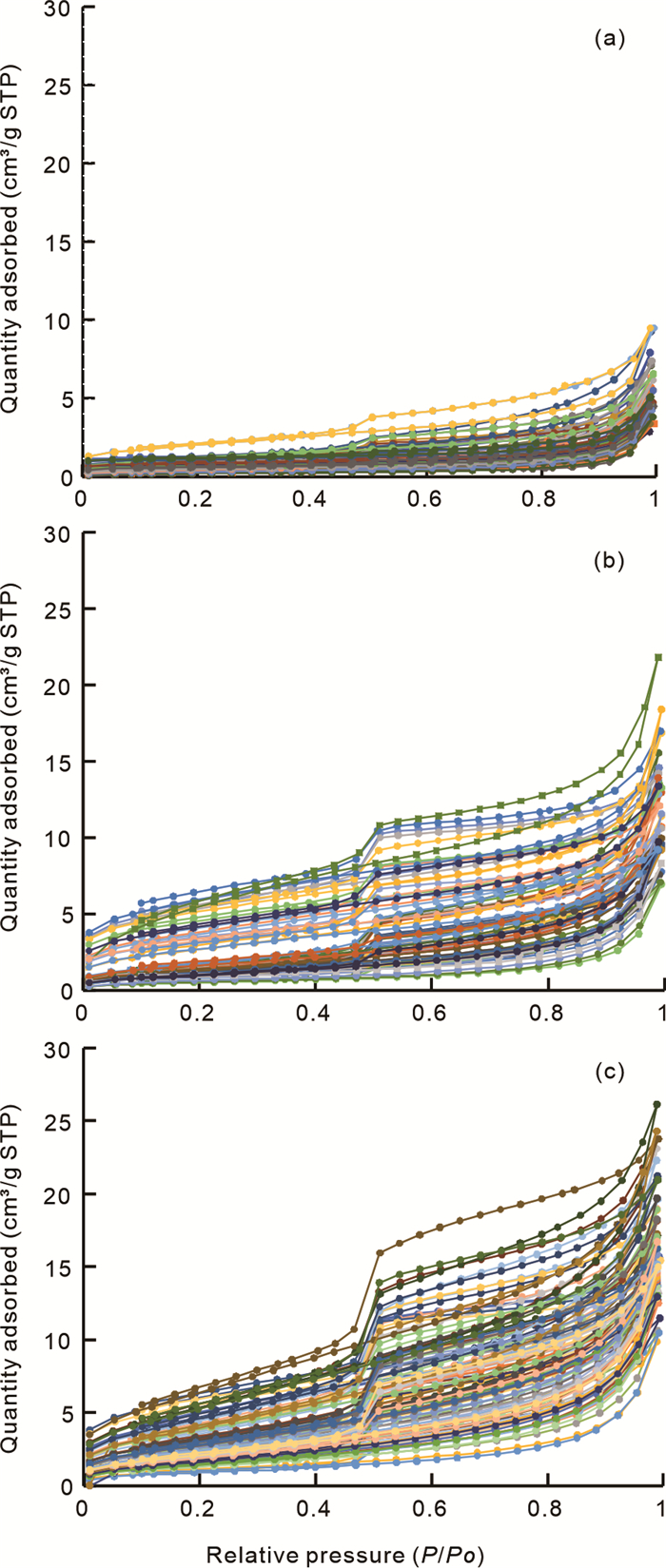
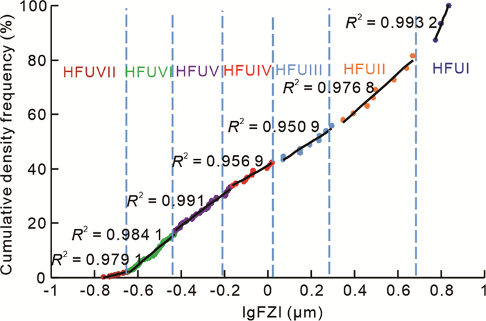
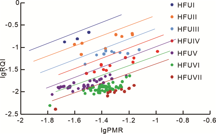
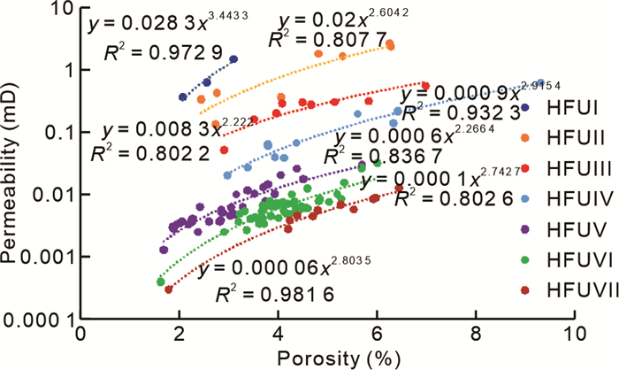
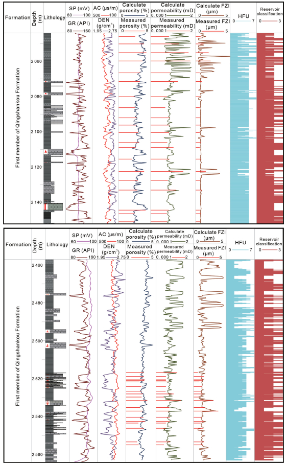
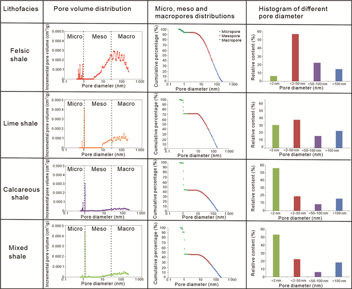
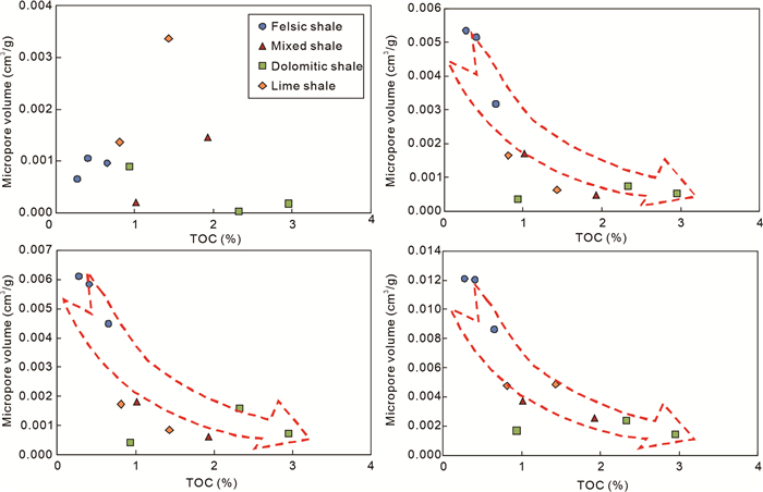
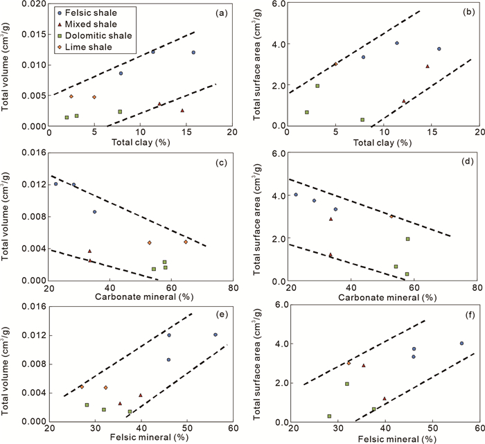
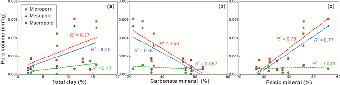
The reservoir's physical properties control the seepage capacity of the shale oil. Developing a method to classify and identify high-quality reservoirs is important to commercial shale oil production. In this study, the Qingshankou Formation shale oil reservoir in the southern Songliao Basin in China was selected. A series of reservoir characterization experiments were conducted to investigate the characteristics of the micropore structure of the reservoir and its influencing factors. A shale reservoir classification evaluation standard was established using fractal theory. It is based on the reservoir micro- and macrocharacteristics. The research results show that the reservoir qualities are controlled by mineral composition, sedimentation, and diagenesis. The larger the pore-throat ratio of the reservoir, the more significant the permeability decrease under compaction. A pore size classification standard based on the shale pore characteristics can be established using fractal theory. There is a coupling relationship between pore size and macroscopic physical properties, which can be used to establish the evaluation standard of the reservoir. Based on the division of hydraulic flow units, the standard can be applied to predict favorable reservoirs.

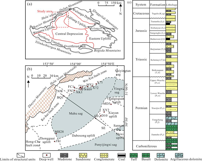
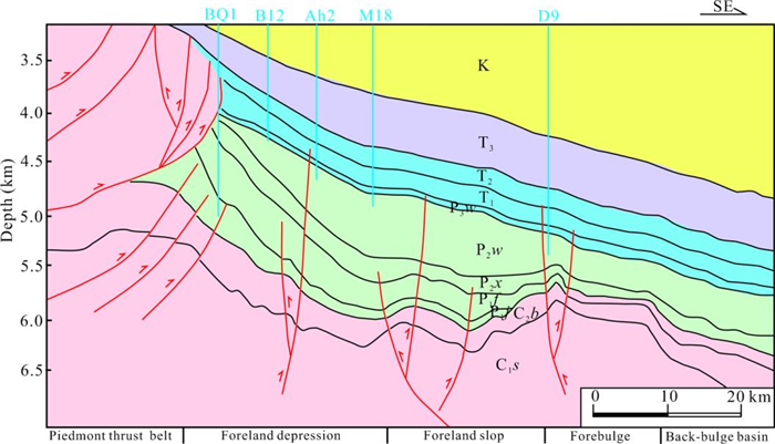
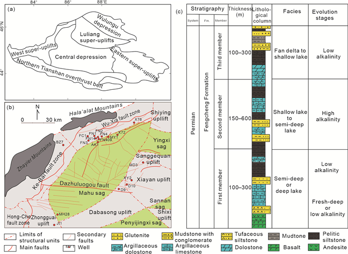
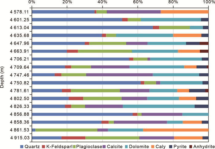
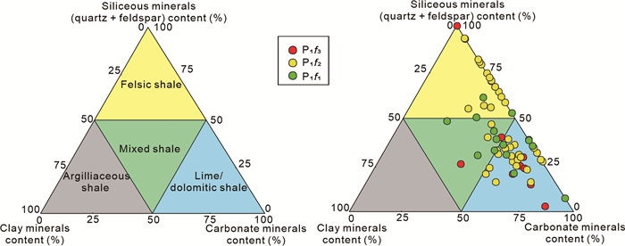
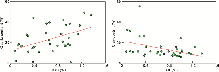
The practice of shale oil exploration and development all over the world has shown that reservoir quality is a key factor restricting oil and gas production, the study of ultra-deep (4 500 m) reservoirs in petroliferous basins is a hot spot for oil and gas exploration in the world today. In this paper, taking the Fengcheng Formation (P1
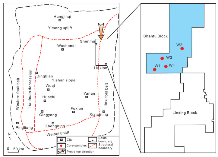
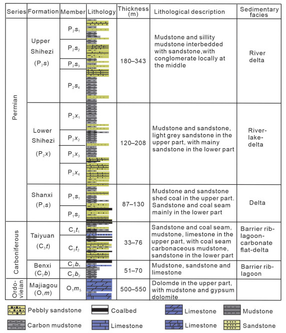
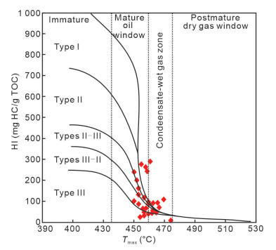
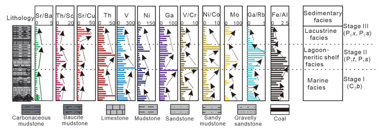
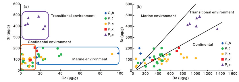
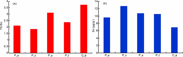
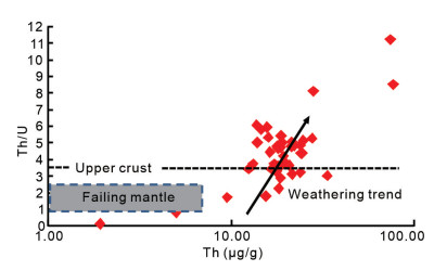
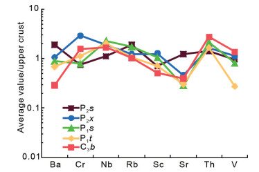
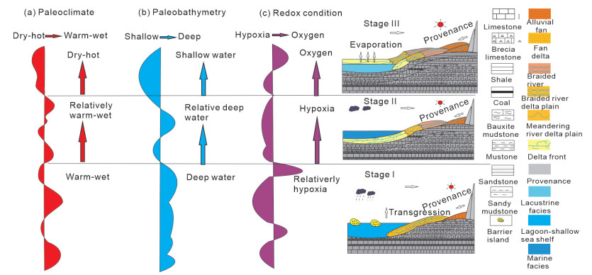
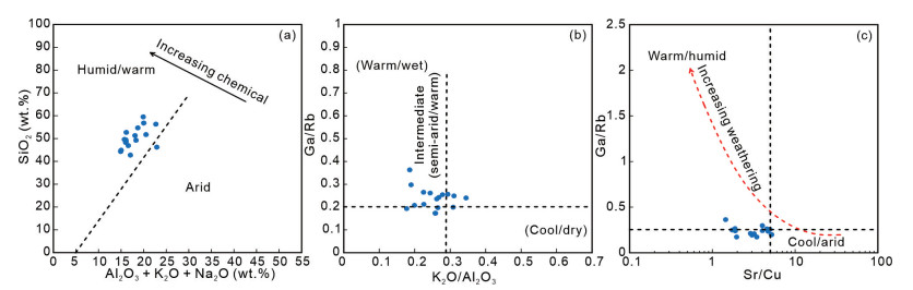
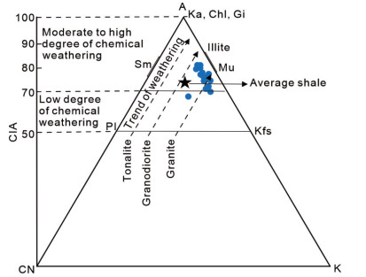
The shale gas exploration of marine-continental transitional facies has gained great attention in China, which is viewed as another breakthrough following the marine shale gas prior to continental shale gas. The Upper Paleozoic marine-continental transitional shales have high TOC abundance with large total thickness in the eastern Ordos Basin, progressively becoming a favorable area for exploration of transitional shale gas. Nevertheless, compared with the relatively homogeneous marine shales, the marine-continental transitional shales demonstrated strong anisotropy in the aspects of thickness, lithology and organic matter (OM). Thus, in this paper, based on the trace element and rock-eval data, we investigated the sedimentary facies, provenance, paleoclimate, paleobathymetry, and redox condition, as well as their controls on the enrichment of organic matter in the Shenfu Block, eastern Ordos Basin. The results of trace element experiments indicate that the paleoenvironment of the Ordos Basin underwent a transition from a marine to a continental environment, evolving from the Benxi Formation of the Carboniferous system to the Upper Shihezi Formation of the Permian system. The provenance area is characterised by the presence of high iron and high magnesium feldspar, with a medium degree of weathering. The paleoclimate experienced alternating periods of dry heat, relatively warm wet conditions, and dry heat. The paleowater depth decreased along the sedimentary profile. With regard to the redox environment index, the Taiyuan Formation is the stratum exhibiting the highest degree of reduction. The detection criteria for biomarkers were found to be consistent with the inorganic geochemical characteristics. The relationship between various trace elements and TOC indicates that redox conditions are the primary factors influencing the accumulation of organic matter in transitional shale. Organic matter is more abundant in warm and humid marine and terrestrial environments than in deep water and anoxic conditions. The characteristics of trace elements can be inferred to suggest that the Benxi Formation and Taiyuan Formation have greater potential for exploration and development.


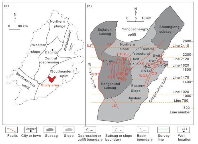
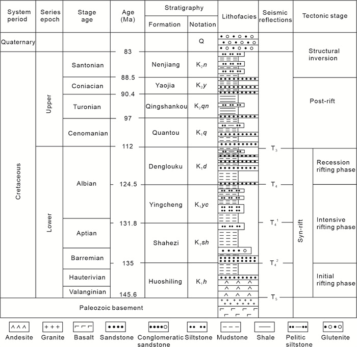
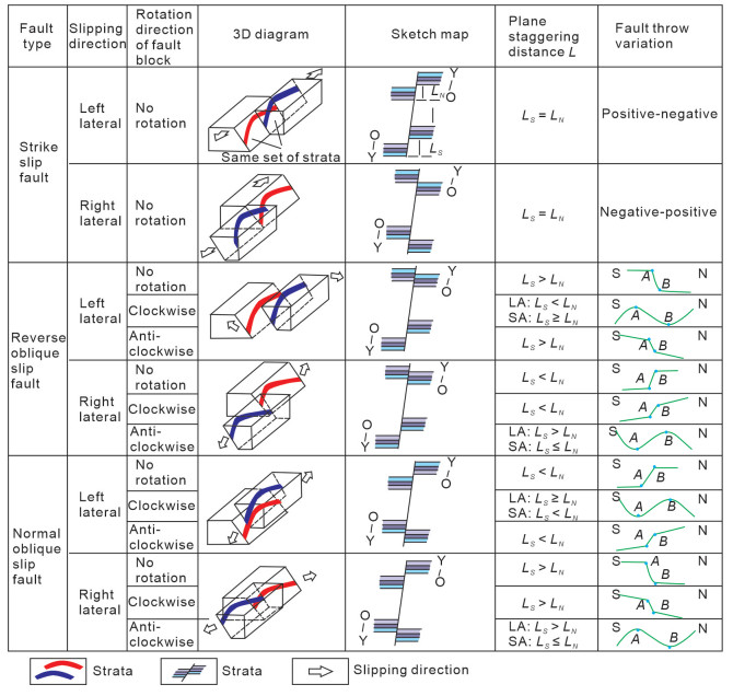
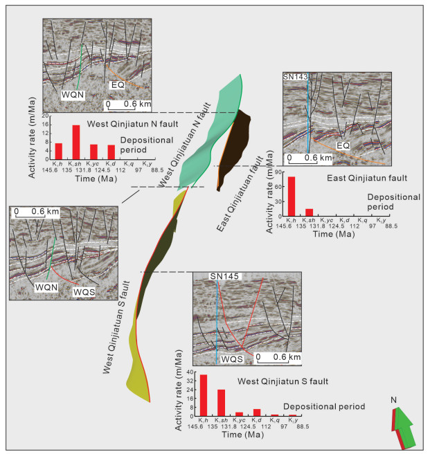
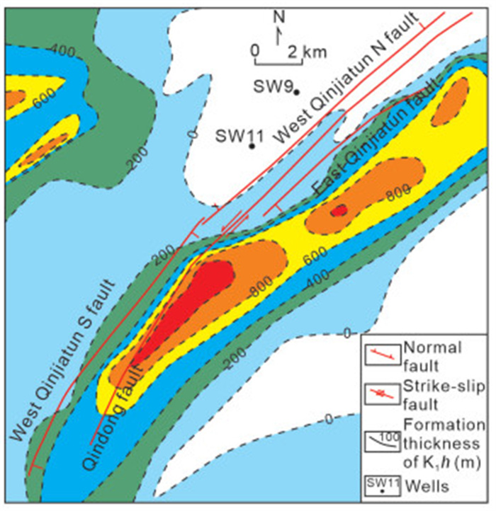
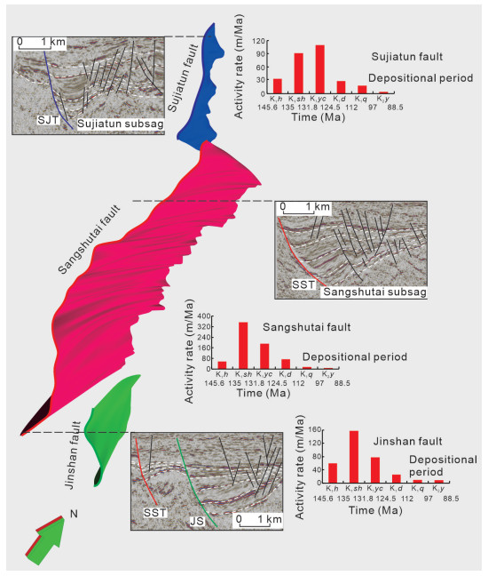
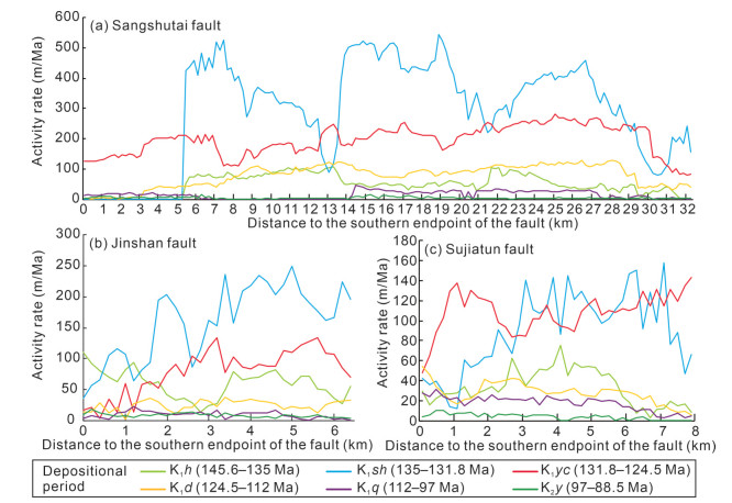
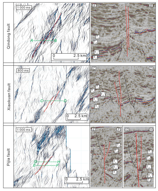
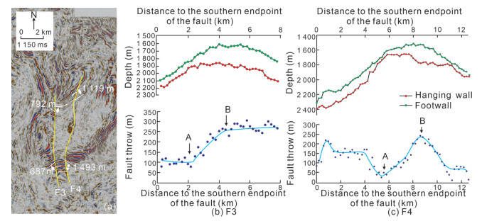
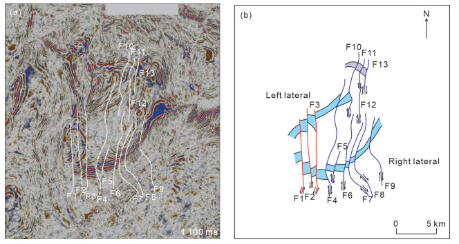
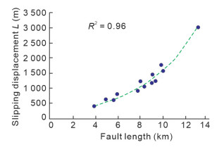
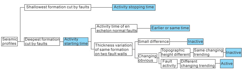
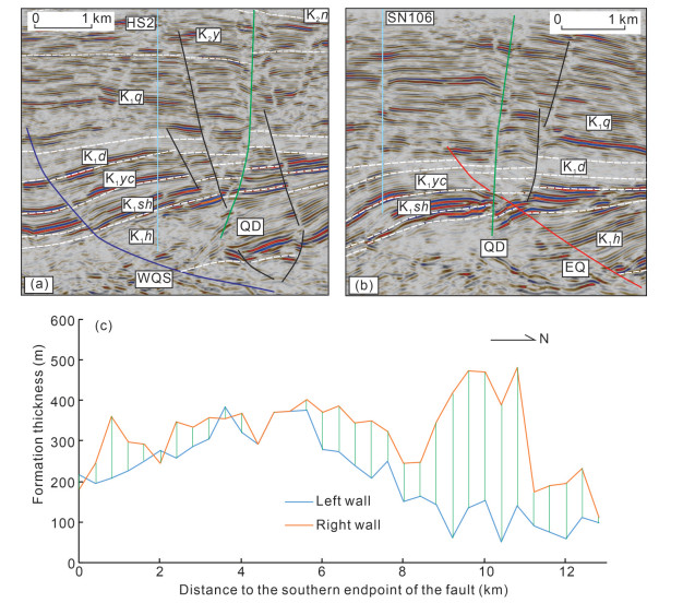
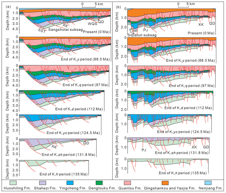
The Lishu depression, located in the southeastern region of the Songliao Basin, exhibits diverse fault types and complex tectonic evolution characteristics. However, the slipping direction and activity duration of strike-slip faults, as well as the overall tectonic evolution process remain unknown. This study applied a method for determining the slipping direction and activity duration of strike-slip faults, and reconstructed the tectonic evolution process of the Lishu depression using balanced cross sections. The determination of the slipping direction of strike-slip faults was based on the analysis of the dislocation distance of a specific set of strata on two fault walls within the anticline zone, and the activity duration of strike-slip faults was defined by the sedimentary period of the strata cut by faults, and the variation characteristics of formation thickness. The slipping direction and activity duration of the strike-slip faults in the study area suggest that the depression experienced a left-lateral strike regime during the sedimentary periods of 135–131.8 and 124.5–112 Ma. However, during the sedimentary periods of the Yingcheng Formation (131.8–124.5 Ma), the region was influenced by a right-lateral strike background. The study area experienced a continuous process of extension from 145.6 to 124.5 Ma, and compression commenced from the depositional period of the Nenjiang Formation (88.5 Ma), as shown by negative values of the extension rate. The findings of this study hold significant theoretical implications for the identification of the slipping direction and distance of strike-slip faults within comparable depressions. Moreover, these results have practical implications for further hydrocarbon exploration in the Lishu depression.
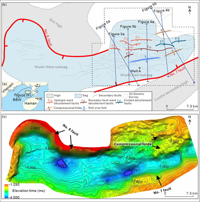
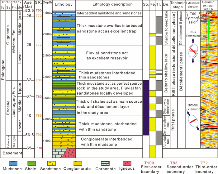
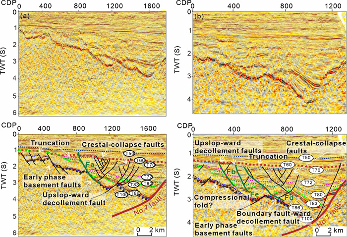
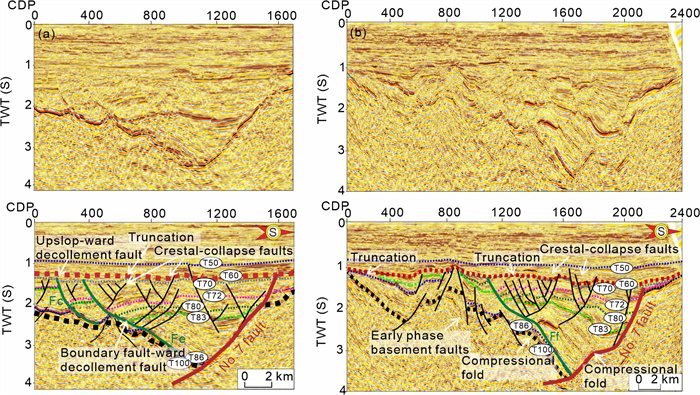
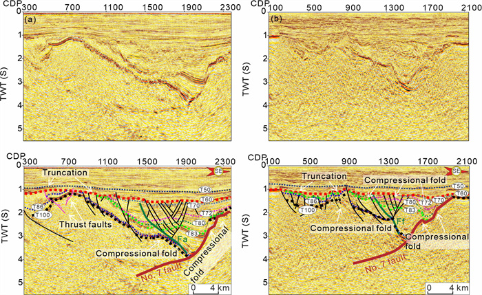
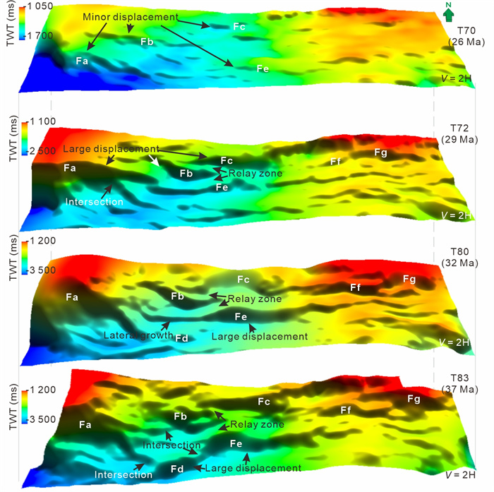
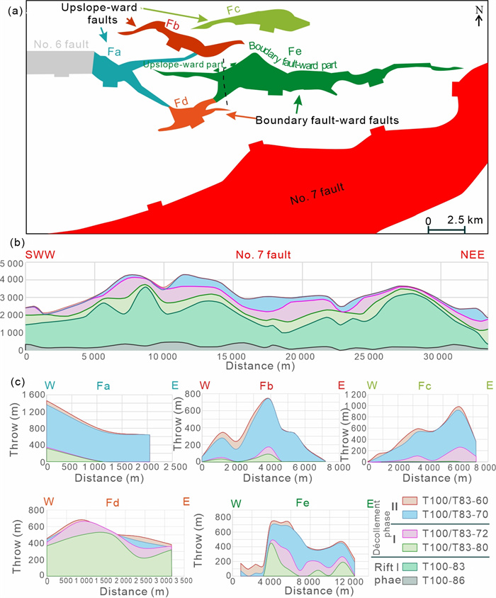
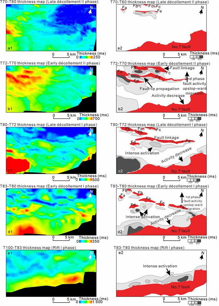
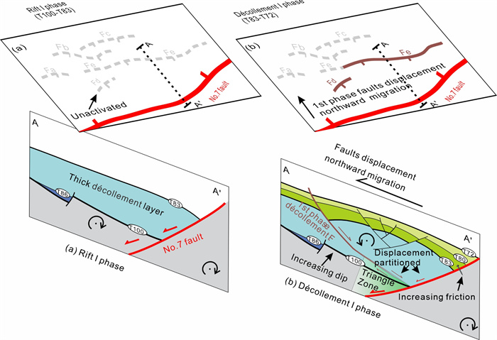
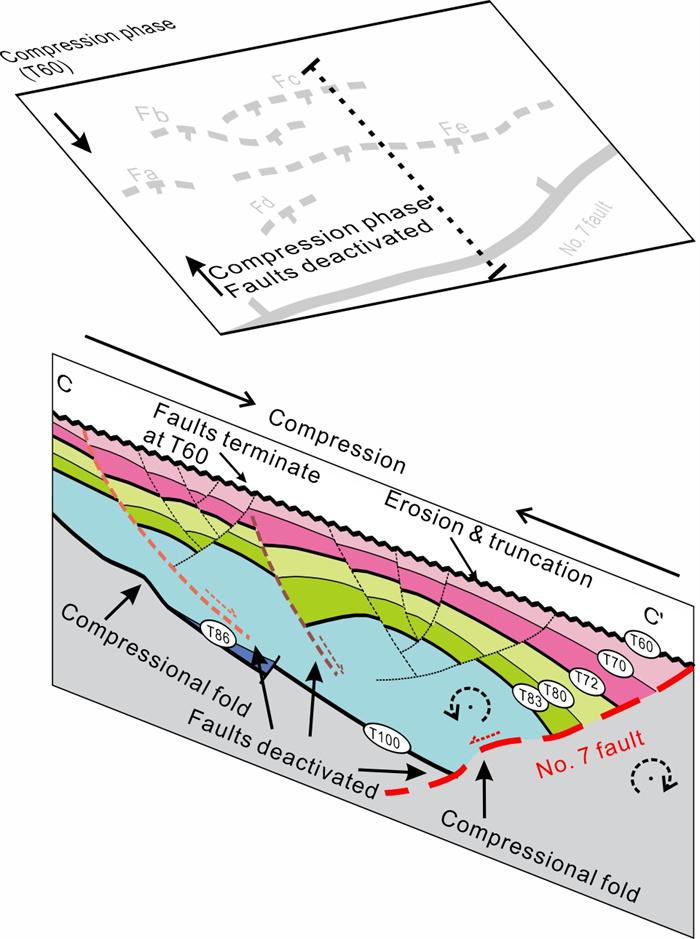
The Wushi sag is located in the central part of the Beibuwan Basin, northern South China Sea. Above the thick oily shale unit in the Wushi East subsag, a suite of terrace-like extensional décollement fault systems exists, which, in conjunction with the No. 7 boundary fault, control a complex fault system. This study integrates the high-resolution 3D seismic data and quantitative analysis of fault displacement to analyze the growth history of the complex fault system and to establish a model of fault system evolution in the Wushi East subsag. The findings reveal two phases of fault growth northward migration during the rifting process. The first phase occurred between the rift Ⅰ phase and the décollement Ⅰ phase, witnessing fault activity migrating northward from the No. 7 boundary fault to the décollement faults (Fd and Fe) in the hangingwall. The second phase occurred between the décollement Ⅰ phase and the décollement Ⅱ phase, with fault activity migrating further northward from Fd and Fe to Fa, Fb and Fd. By the end of the Oligocene, basin inversion controlled the syn- to post-rift transition of the Wushi East subsag. This study bears significant implications for hydrocarbon exploration and for understanding the mechanism underlying the syn- to post-rift process in the north continental marginal basins of the South China Sea.

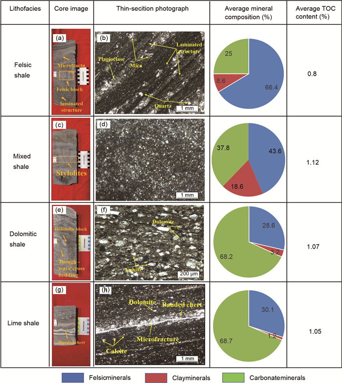
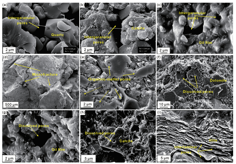
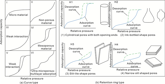
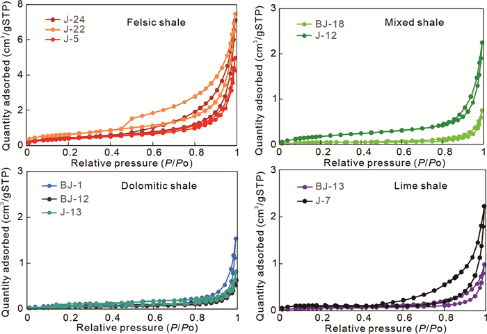
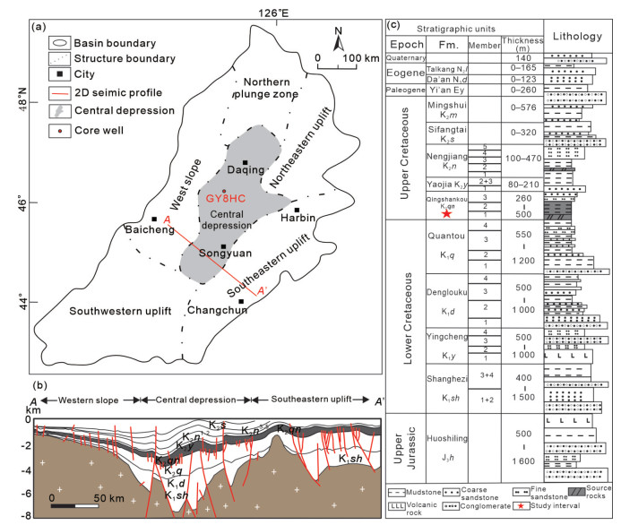
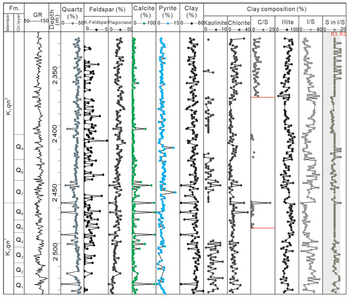
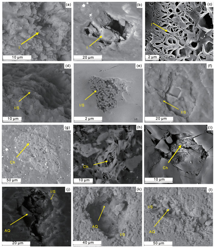
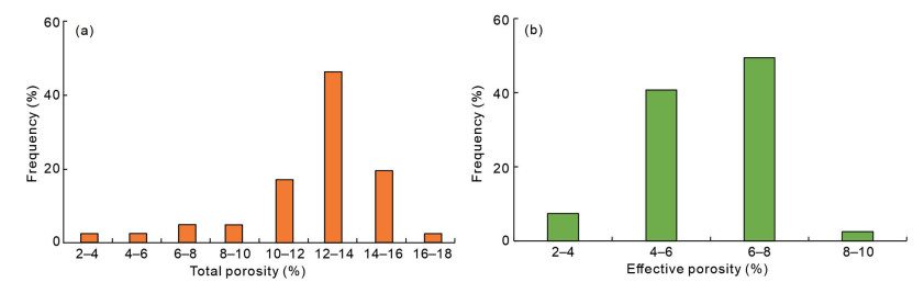
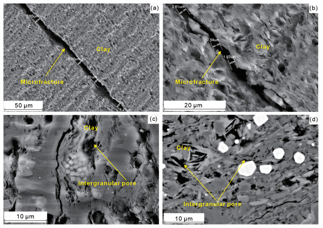
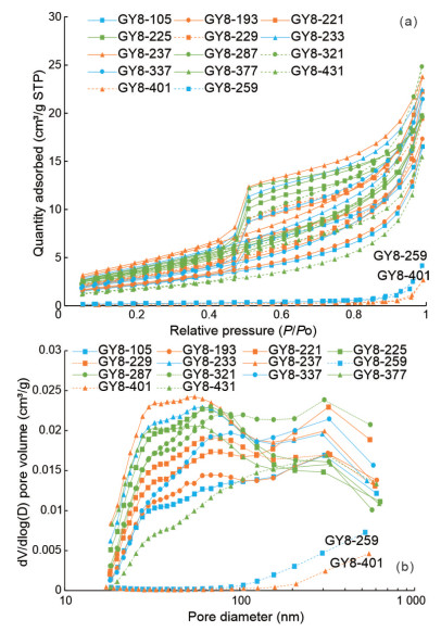
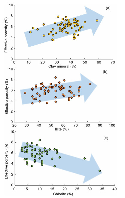
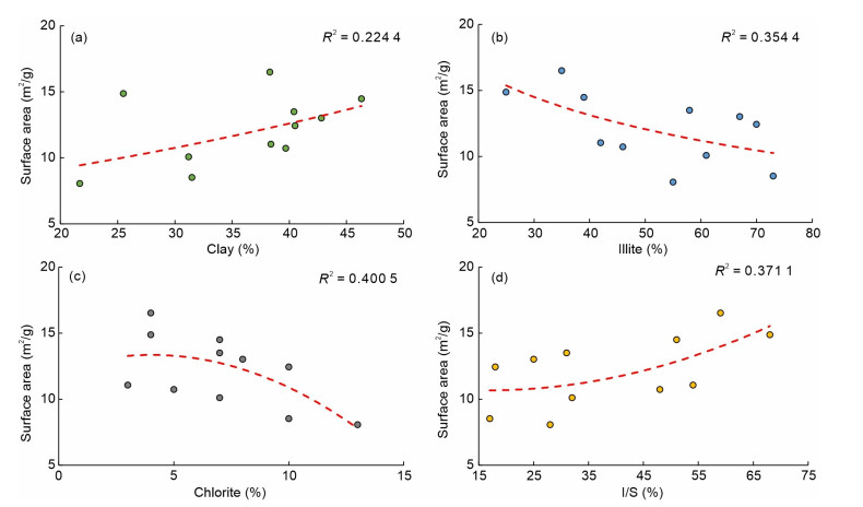
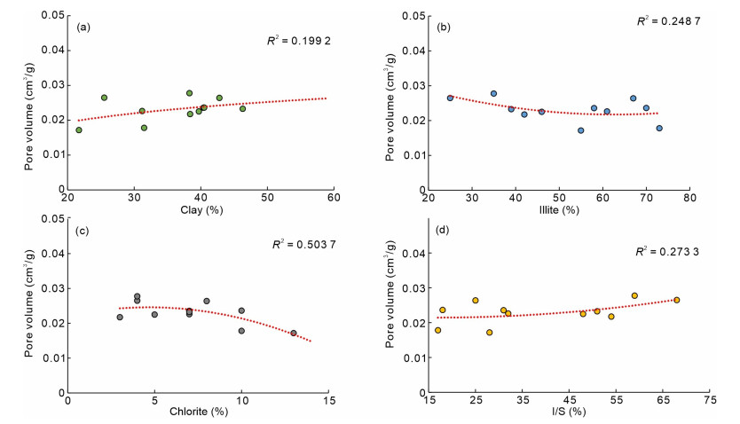
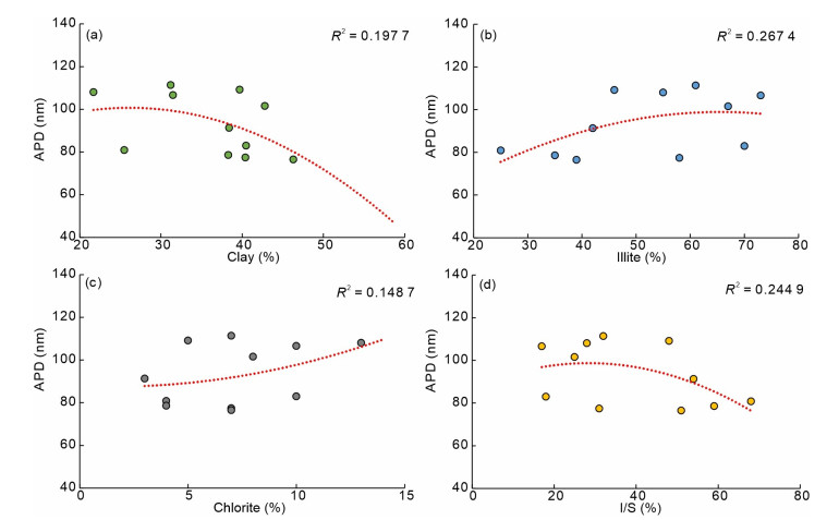
Currently, significant hurdles lie ahead in China's lacustrine shale oil exploration and exploitation, particularly due to the high clay mineral content, which severely impacts pore development in organic-rich shales. In this study, we take the medium- to high-maturity shale of the Qingshankou Formation (K2

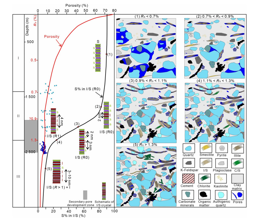
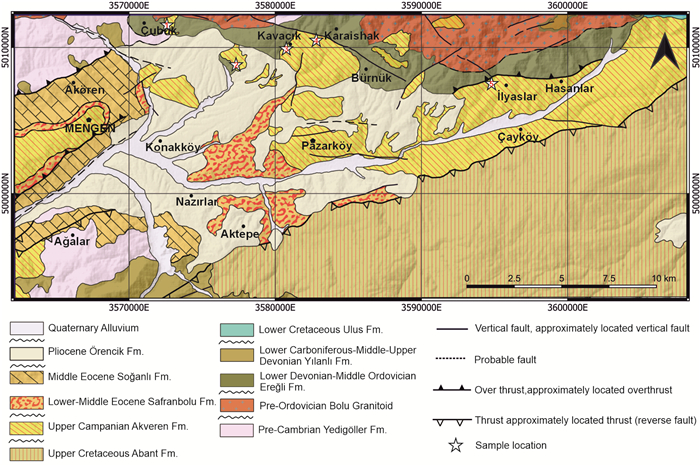
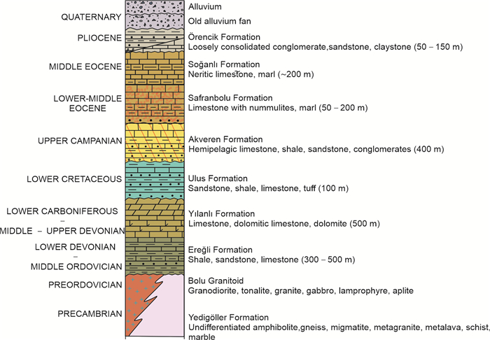
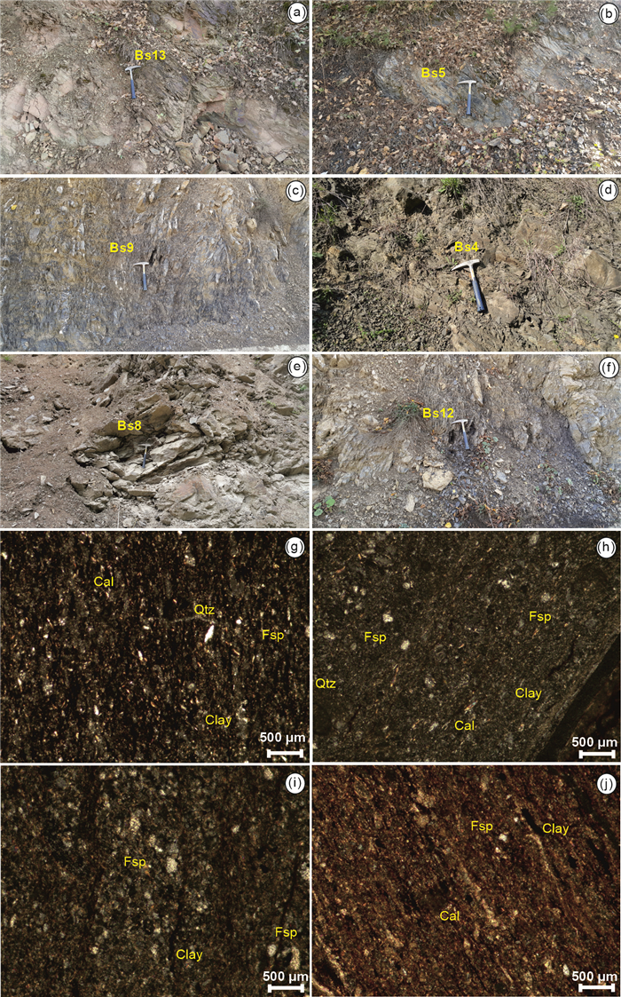
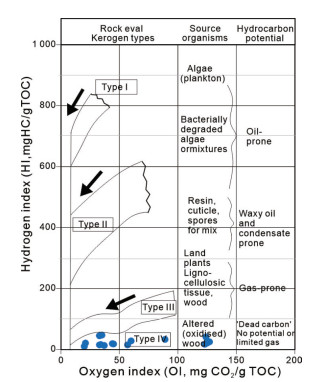
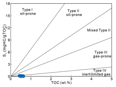
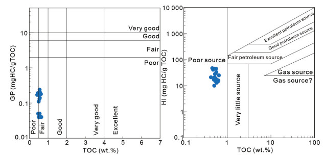
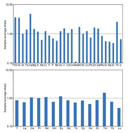
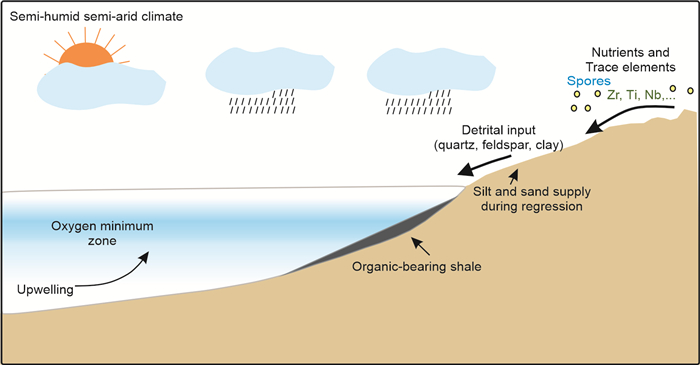
This study investigates the factors controlling organic matter accumulation in organic-bearing shales around the Bolu area of Western Pontides and their implications for hydrocarbon potential through elemental and organic geochemical analyses. The organic-bearing shales in this area contain both organic matter and various critical trace elements and also attract interest as a hydrocarbon resource. In the end, the paleoceanographic model of the depositional environment was established. The findings indicate that the studied shales were deposited in a shallow-marine shelf environment with a brackish to saline marine setting, under semi-humid to semi-arid paleoclimate conditions, and subject to low to moderate chemical weathering. However, paleoclimate and variability in water column productivity did not significantly influence organic matter enrichment. Redox indicators suggest deposition occurred under oxic to suboxic conditions, with minor oxygen deficiency aiding organic matter preservation. Fluctuations in sedimentation rate likely influenced organic matter by either promoting its degradation in an oxidizing environment or diluting its concentration. While detrital input contributed to organic matter enrichment, clay minerals did not appear to play a significant role in its preservation. These shales exhibit fair organic matter content and are characterized by Type Ⅳ kerogen, indicating limited or no gas generation potential, thereby classifying them as spent hydrocarbon sources. Furthermore, prolonged atmospheric exposure of outcrop samples may have led to organic matter degradation, resulting in residual carbon at high thermal maturity. By integrating multiple geochemical proxies, this study presents the first comprehensive assessment of these shales, offering new insights into their hydrocarbon potential.
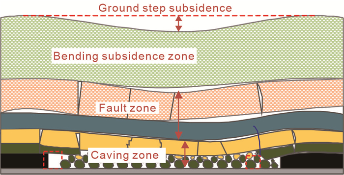
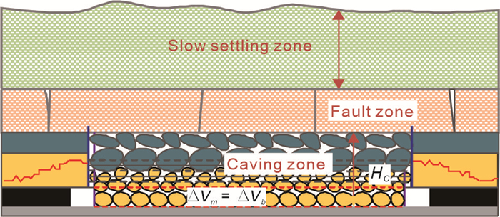
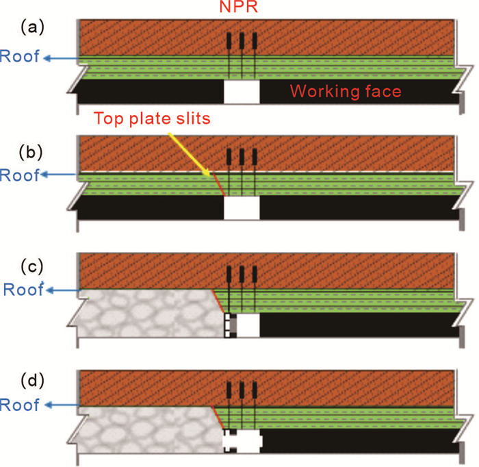
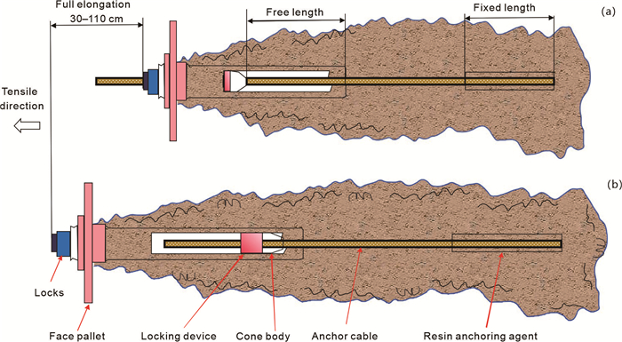
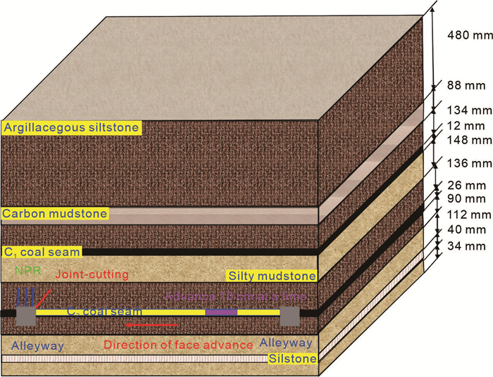
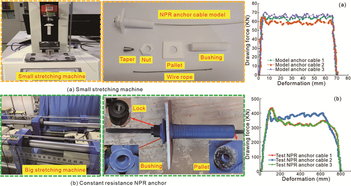
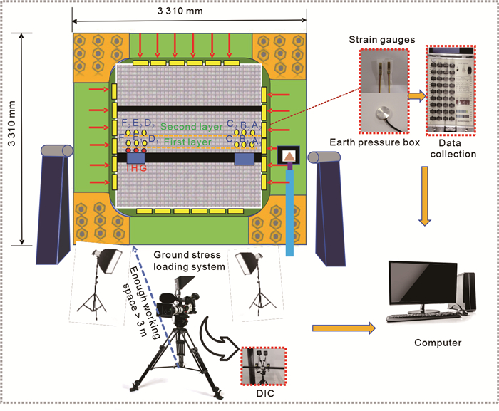
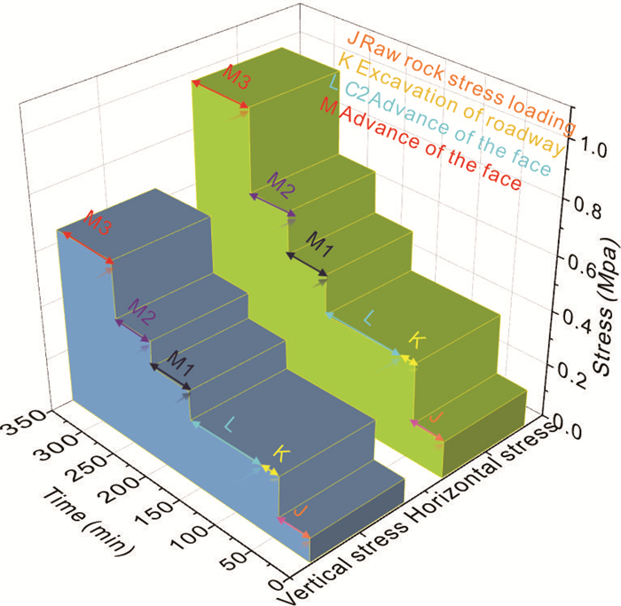
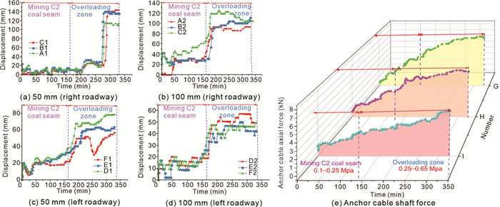
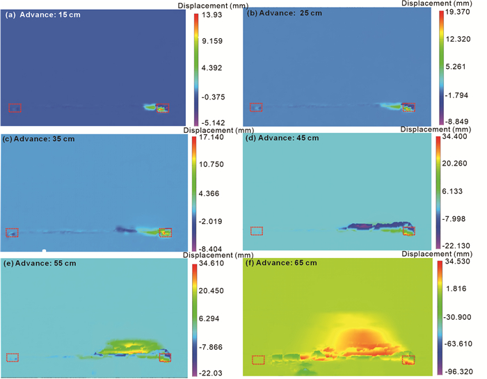
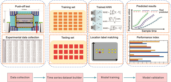
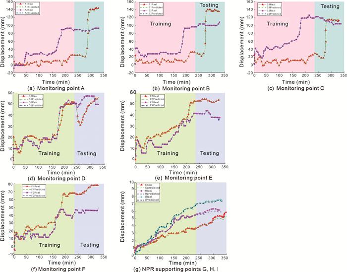
This study presents a new coal mining technique that uses top-cut unloading to induce the fragmentation and expansion of collapsed ore. Stress compensation and control are achieved by using a constant-resistance, large deformation anchor cable. The research employs laboratory physical model tests and an artificial neural network (ANN) time-series prediction model to monitor, analyze, and predict the movement and crack development of the overlying rock layers in tunnels. The results show that the support characteristics of constant-resistance, large-deformation anchor cables, combined with the filling effect of collapsed ore fragmentation and expansion, automatically form tunnel supports. This new mining method significantly reduces the displacement of the overlying rock layers and minimizes surface subsidence. Furthermore, the ANN time-series prediction model accurately forecasts displacement at multiple monitoring points in the overlying rock mass and the axial force of constant-resistance, large deformation anchors. This innovative mining method provides valuable insights for ecological protection and exploration of underground works.


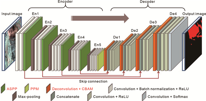
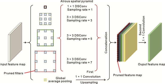
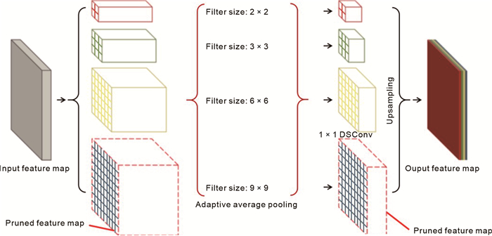
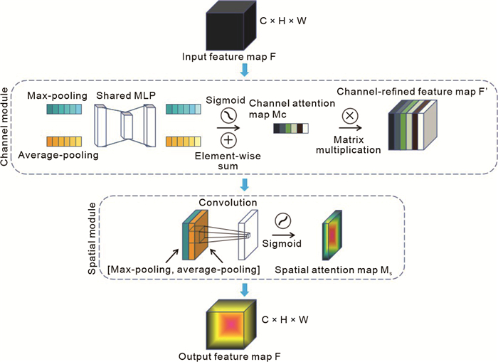
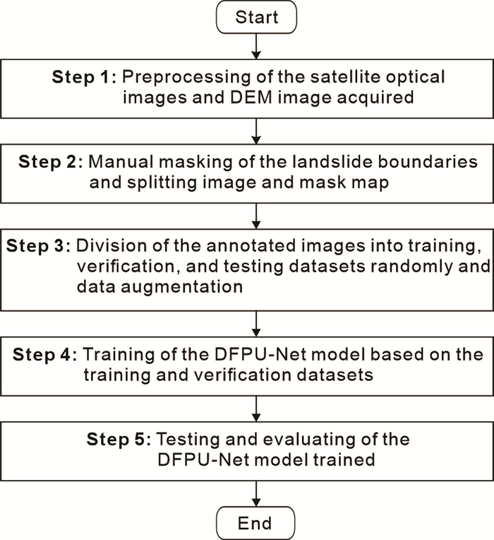
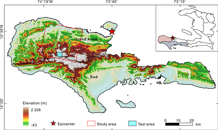
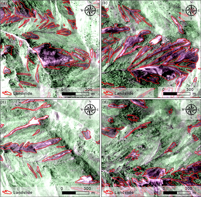
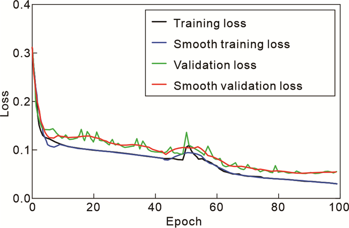
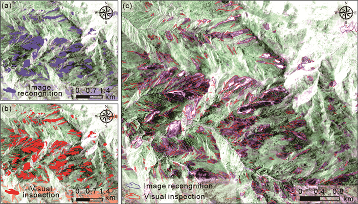
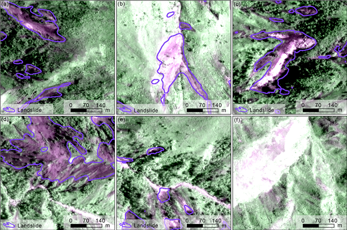
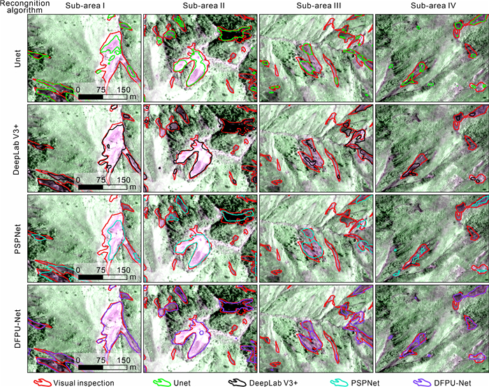
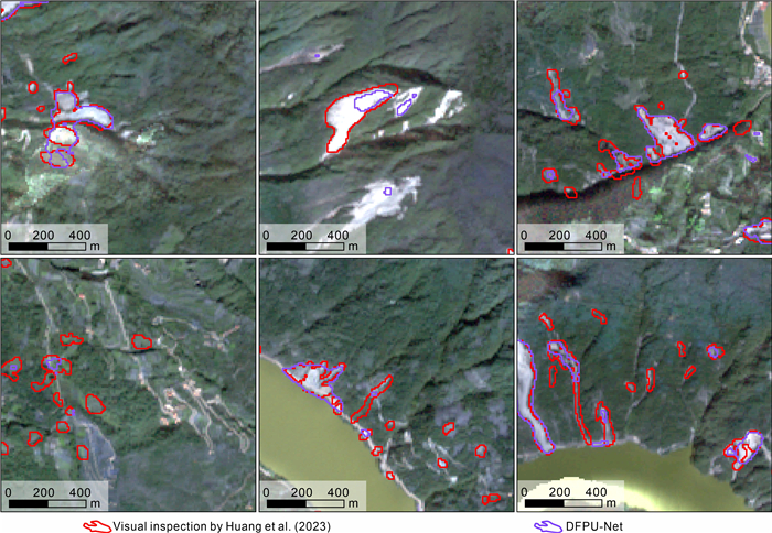
Landslides are widely distributed in mountainous regions around the world. Rapid mapping of earthquake-induced landslides in mountainous areas plays a crucial role in post-disaster assessment and rescue planning. In mountainous areas, it is challenging to identify small landslides using existing landslide mapping methods accurately. To address this challenge, this paper proposes a dual feature pyramid-based UNet (DFPU-Net) model, which utilizes the VGG16 model as the backbone feature extraction network. Meanwhile, two modified pyramid-structured modules, in terms of the atrous spatial pyramid pooling (ASPP) module and pyramid pooling module (PPM), are integrated into the backbone feature extraction network. Furthermore, the features of landslides extracted by the enhanced feature extraction network are screened by the deconvolution layers and convolutional block attention module (CBAM). To demonstrate the effectiveness of the proposed model, landslides in Grand'Anse and Sud departments, induced by the 2021 Haiti
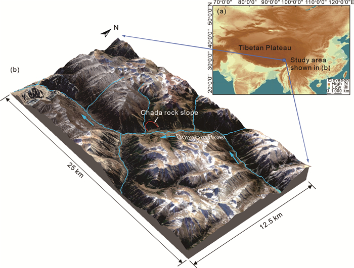
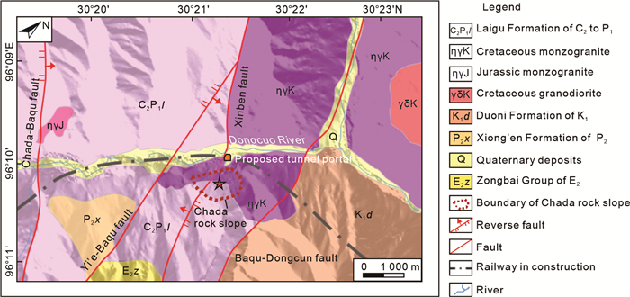
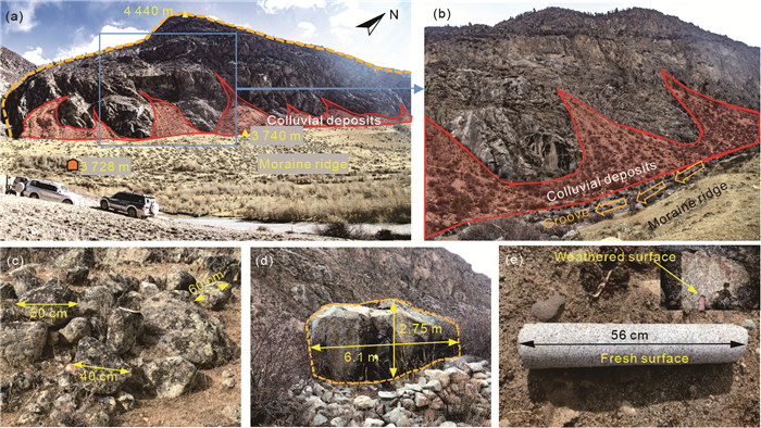
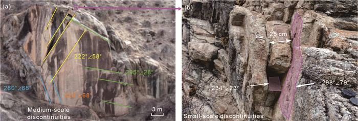
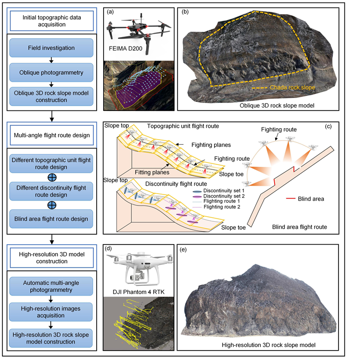
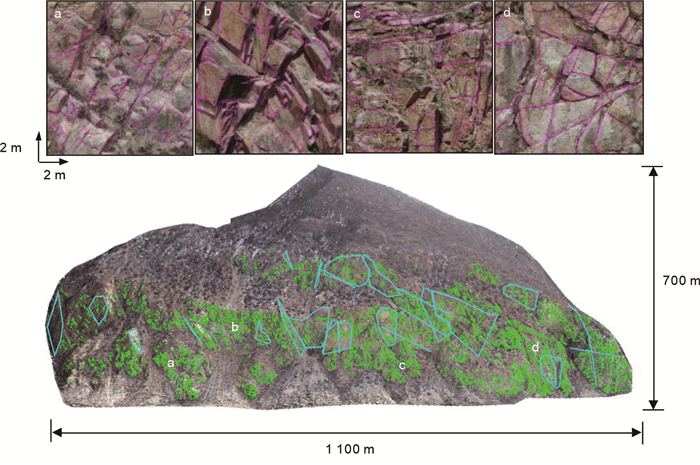
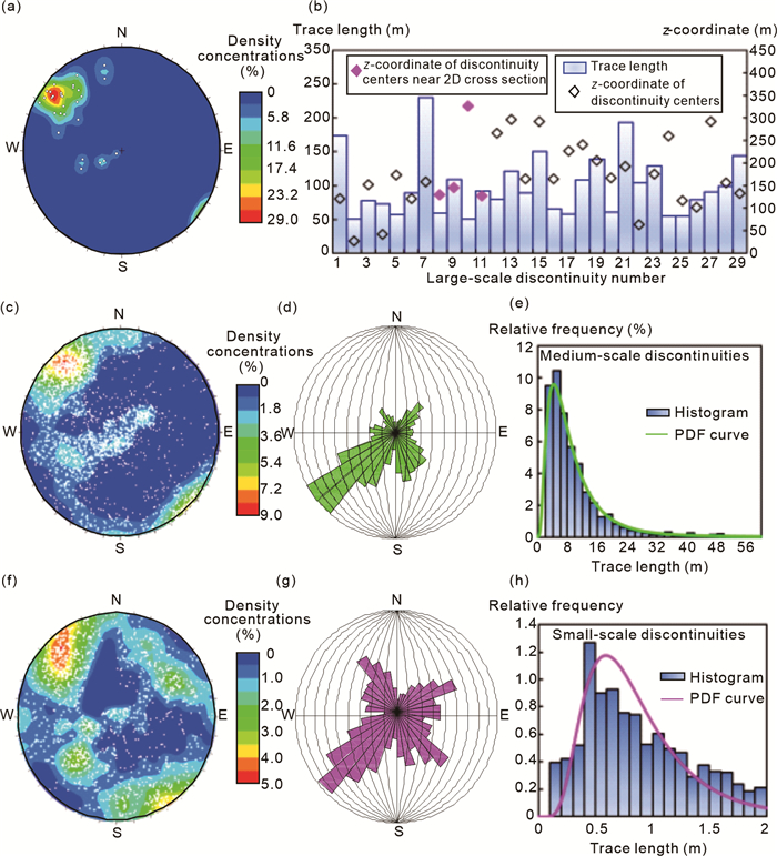
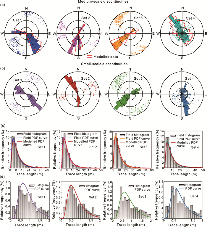
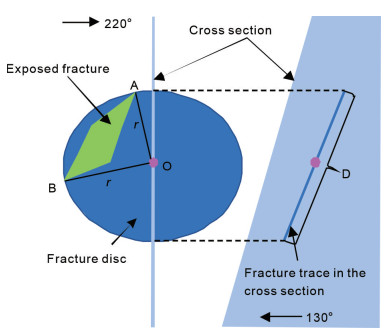
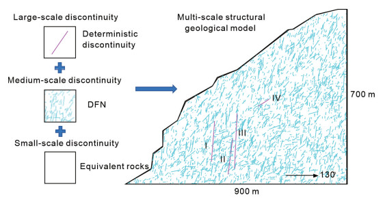
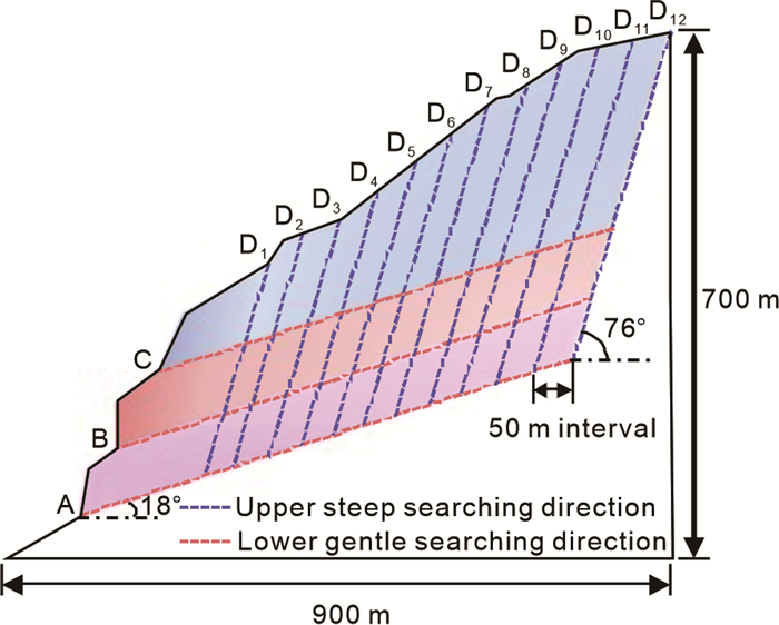
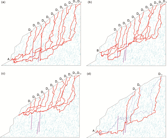
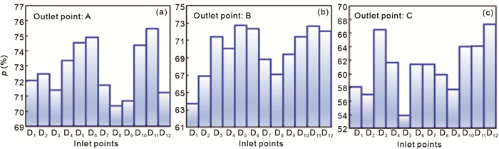
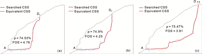
This study aims to evaluate the stability of a high-steep fractured rock slope on the right bank of Dongcuo River, Southeast Tibetan Plateau by establishing a multi-scale structural geological model. Multi-scale discontinuity information was first identified via unmanned aerial vehicle photogrammetry. The multi-scale structural geological model for the cross section of the slope was established by multi-scale discontinuity processing. In particular, large-scale discontinuities were directly embedded into the model, medium-scale discontinuities were realized via discrete fracture network simulation technology, and small-scale discontinuities were implicitly considered in the equivalent rock parameter calculation. A staged scheme for searching the shortest paths of the multi-scale structural geological model via Dijkstra's algorithm was established. The searched shortest path with the largest discontinuity persistence passes the most fractures and processes the lowest shear strength, which can represent the critical slip surface (CSS). Three potential CSSs were selected for the quantification of the factor of safety (FOS) using the transfer coefficient method. Modified Jennings' criteria were proposed to estimate the equivalent shear strength of the CSS composed of rock bridges and discontinuities. Finally, FOS is calculated as 3.81, implying that the studied rock slope remains stable.
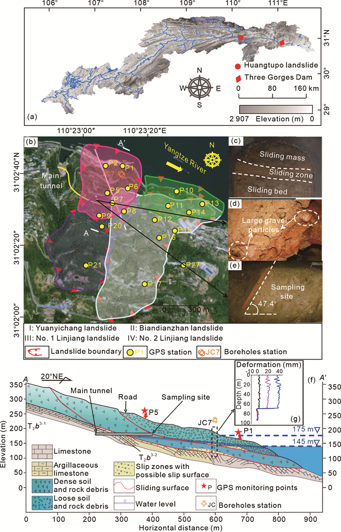
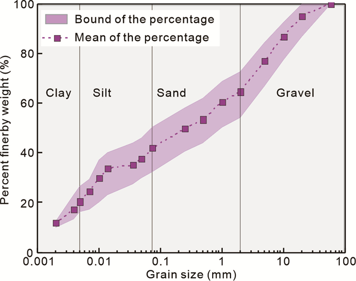
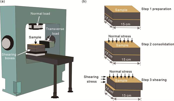
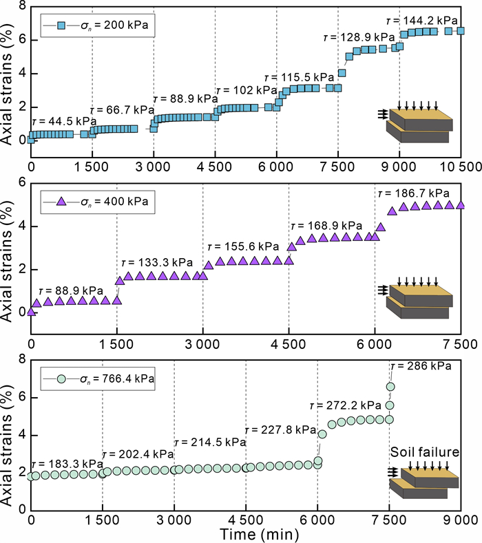
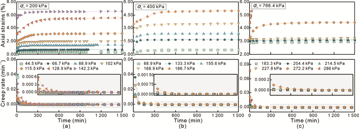
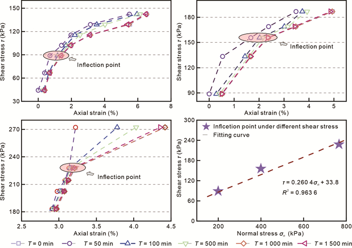
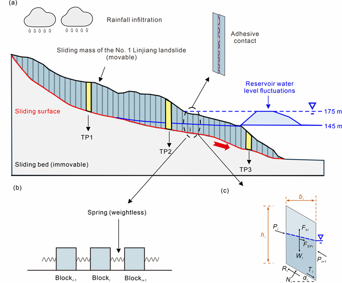
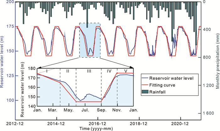
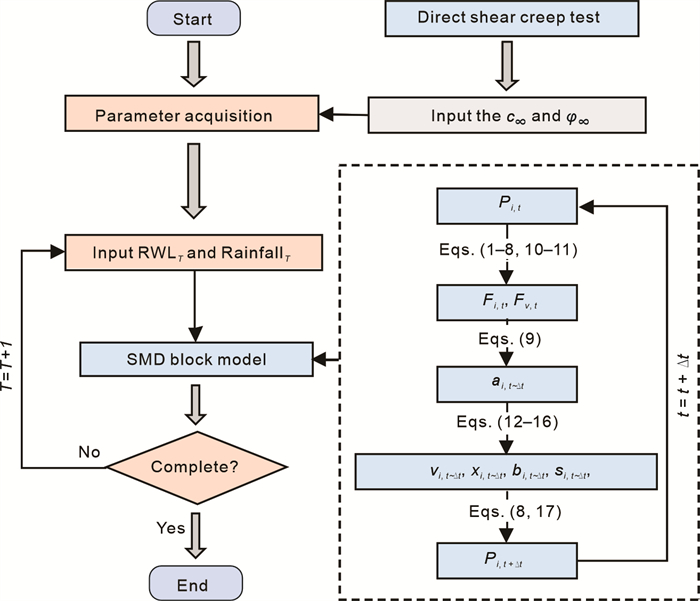
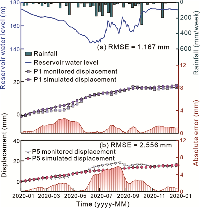
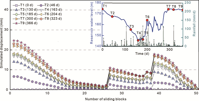
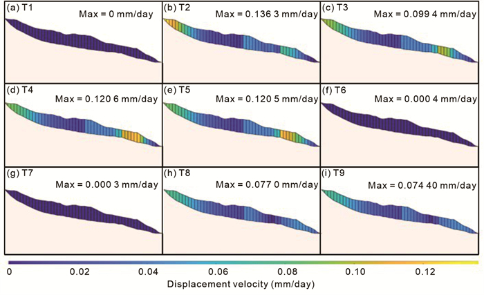
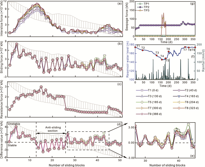
Creeping reservoir landslides experience slow, ongoing deformation driven by cyclical hydrological conditions, posing a significant threat to hydropower infrastructure and nearby communities. Long-term high consolidation pressure leads to the formation of a dense soil matrix unique structure in the slip zone soils, significantly affecting creeping reservoir landslides evolution. However, current studies often fail to adequately describe and incorporate creep properties of the intact slip zone soils, resulting in a lack of precision and efficiency when simulating the progressive evolution process of creeping reservoir landslides. This study conducted a series of large-scale direct shear creep tests on the intact slip zone soils, from No. 1 Linjiang landslide of the Huangtupo landslide in the Three Gorges Reservoir area (TGRA), to investigate their creep behavior and long-term strength. Subsequently, a seepage-mechanical-deformation (SMD) block model was developed, offering higher computational efficiency and the ability to dynamically adapt to real-time hydrological boundary conditions, and providing a novel framework for simulating the progressive evolution of the No.1 Linjiang landslide. The experimental results indicate that the intact slip zone soil exhibits distinct creep characteristics and a notable long-term strength. The performance of the SMD block model was further validated through comparison with monitoring data over one hydrological year. Furthermore, the simulation results highlight that the primary deformations occur at the front and rear of the landslide, and the middle acting as an anti-sliding section. Overall, this study advances the understanding of creeping reservoir landslide progressive evolution processes and enhances the simulation capabilities of landslide deformation, providing valuable insights for risk assessment and mitigation strategies in the TGRA.
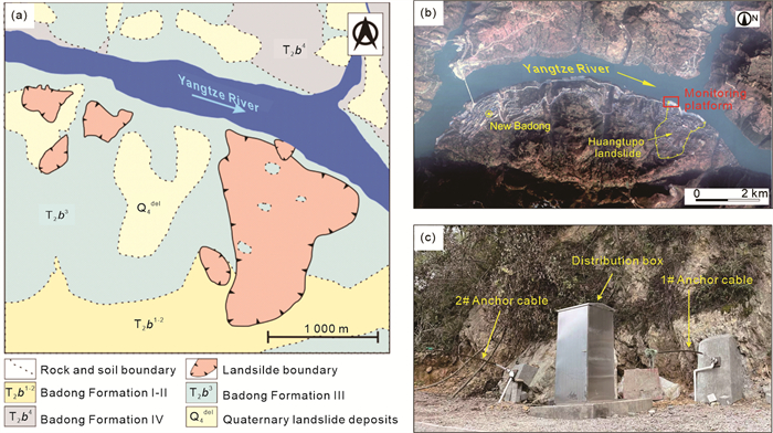
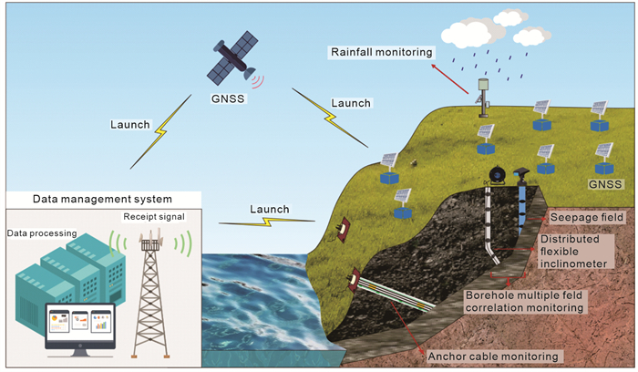
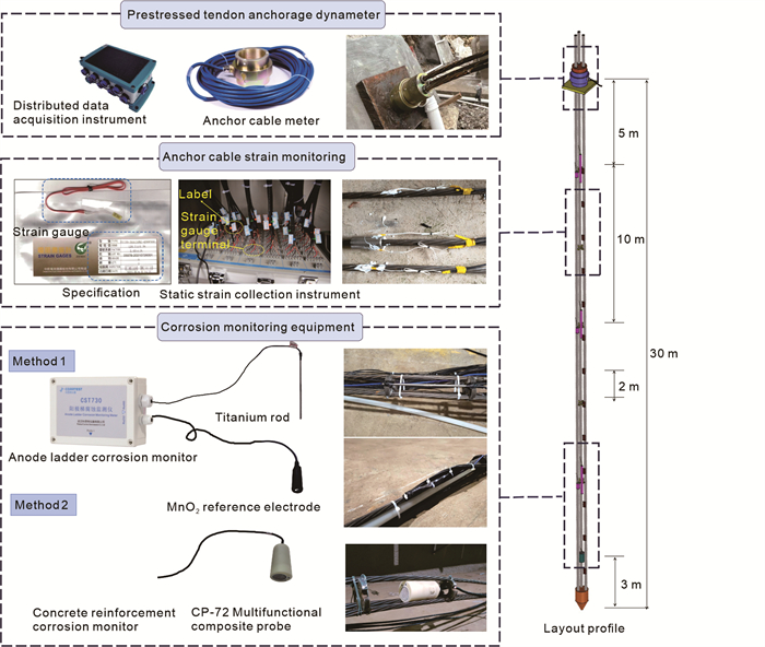
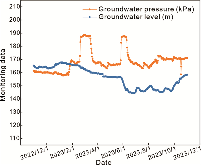
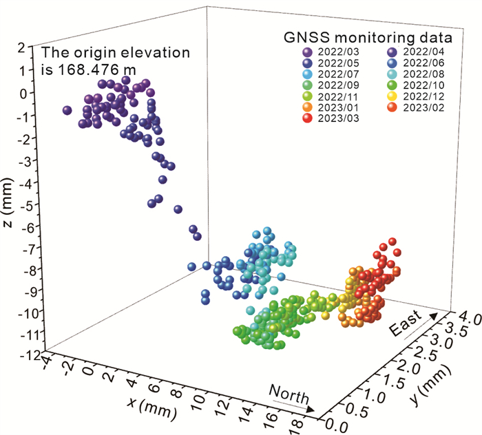
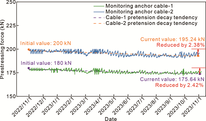
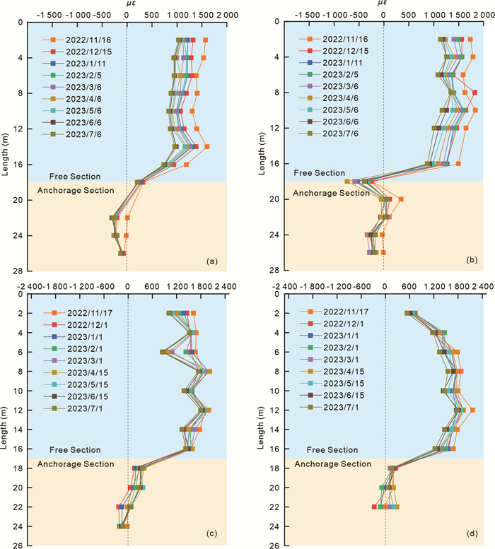
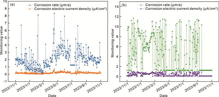
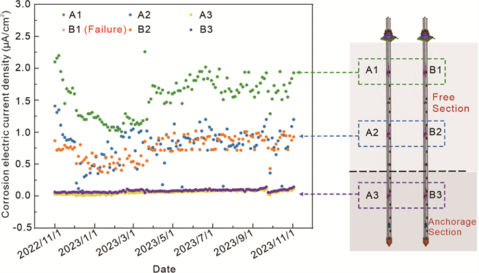
The geological environment in which the reservoir slope is situated is intricate, influenced by factors such as precipitation and fluctuations in reservoir water levels. Furthermore, the anchoring structure embedded within the rock mass of the slope undergoes corrosion and deterioration due to these factors, resulting in a highly complex interaction process between the slope rock mass and the anchoring structure. The long-term safety of rock-anchored structure systems is closely tied to the construction and safe operation of reservoirs, as both internal and external factors play a role in ensuring their stability. The present study aims to investigate this intricate issue by designing and establishing an on-site comprehensive multi-field information monitoring platform. The multi-site information monitoring platform comprises three components, namely the landslide monitoring system, anchor structure monitoring system, and data management system. The landslide monitoring system encompasses the surveillance of surface deformation, subsurface deformation, and environmental factors. The monitoring system for anchor structures includes the monitoring of prestress, anchor cable strain, and corrosion status of steel bars. The establishment of a preliminary system for data transmission and management has been accomplished. The current monitoring results indicate that the health condition of the tested anchor cables is satisfactory, and the strain and corrosion status are influenced by the design of the anchor cable structure. The platform is currently undergoing enhancements with the incorporation of cutting-edge anchoring structure design and monitoring equipment.
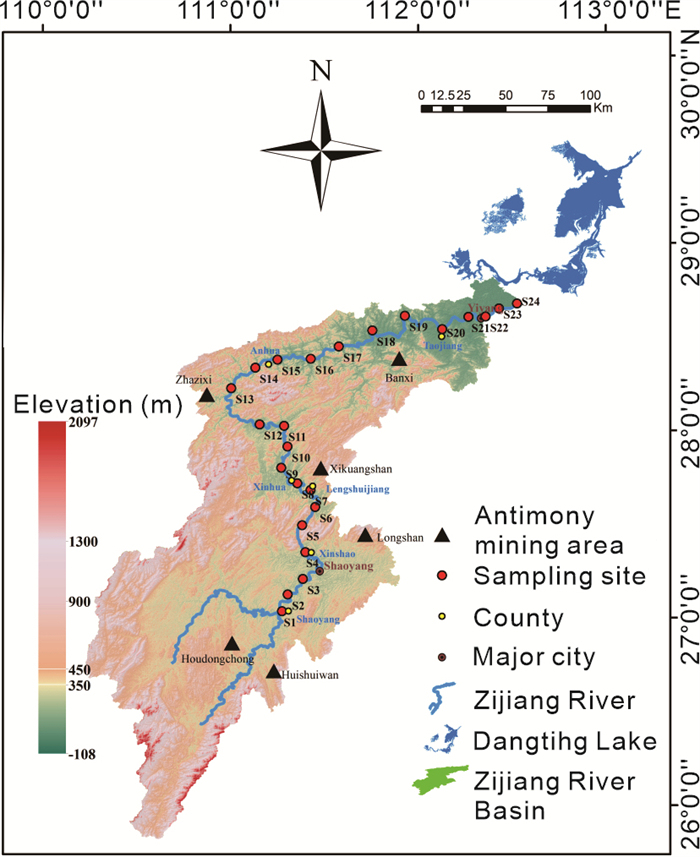
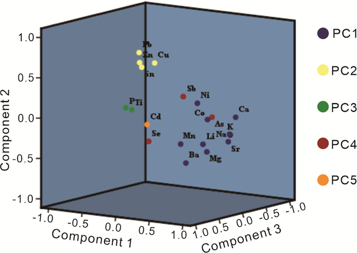
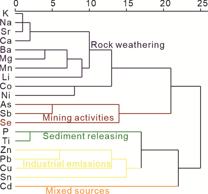
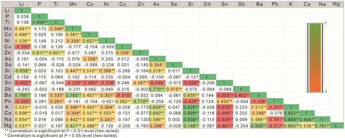
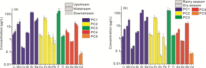
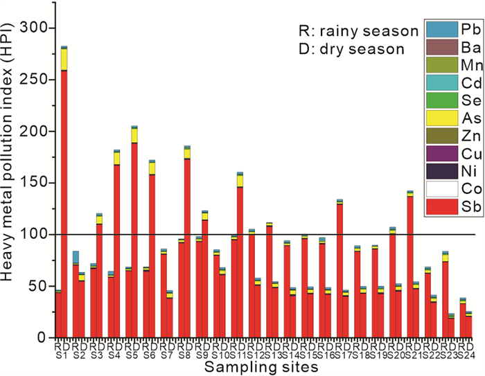
The Zijiang River Basin is home to the world's largest antimony reserves, but it also grapples with severe ecological contamination. Notably, there is a lack of information on surface water pollution, particularly with regard to trace elements (TEs). In order to gain a better understanding of the situation, risk, and sources of TEs, we conducted an extensive study on the Zijiang River. Our findings revealed that 95.83% of the samples had antimony levels exceeding China's drinking water limit of 5 μg/L. By using multiple multivariate statistical techniques, we identified five main sources of TEs. Sr, Mn, Co, Ni, and Ba are primarily derived from the natural weathering of rocks. Human activities, such as industrial emissions, are major contributors to the presence of Pb, Cu, Zn, and Sn. P and Ti are released from sediment influenced by cascading reservoirs. Sb, As, and Se stem from antimony mining activities. The hazard index indicated that antimony poses a non-carcinogenic risk to human health, with children being especially vulnerable. Furthermore, antimony was found to be the most significant factor for residential exposure. Consequently, we recommend paying close attention to antimony pollution and intensifying research efforts on antimony in the Zijiang River Basin.
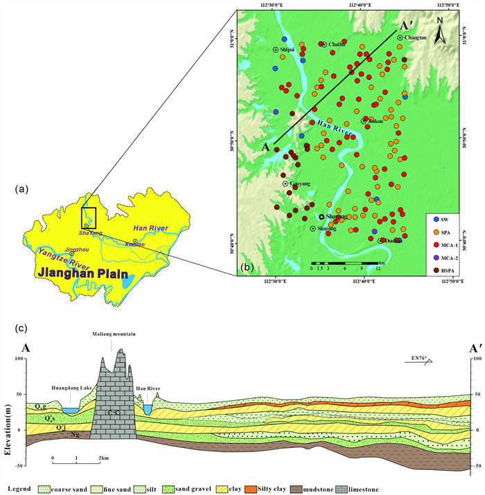
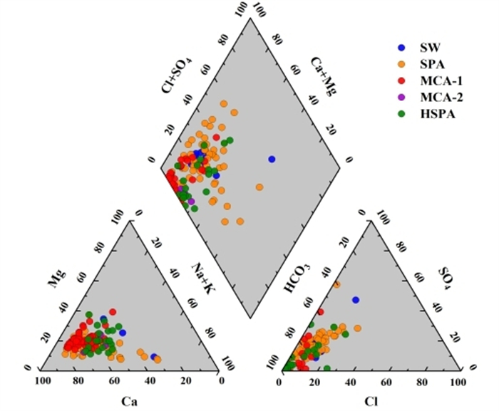
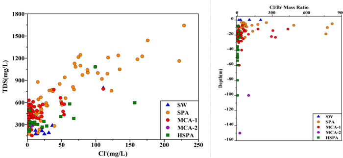
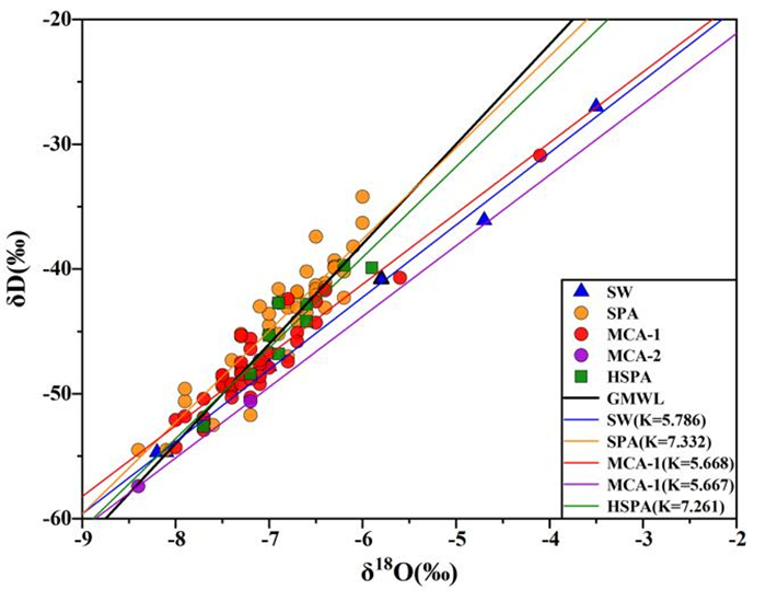
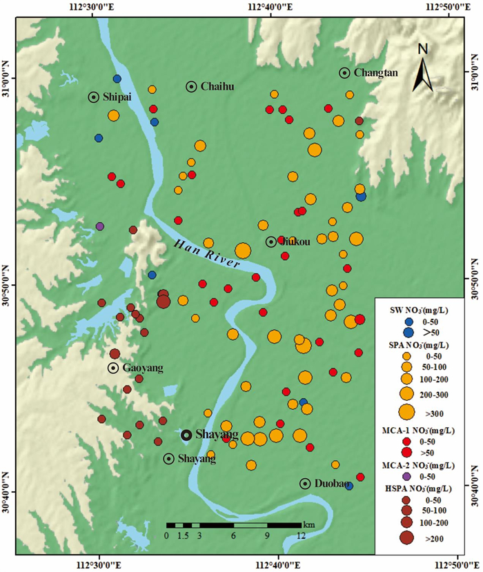
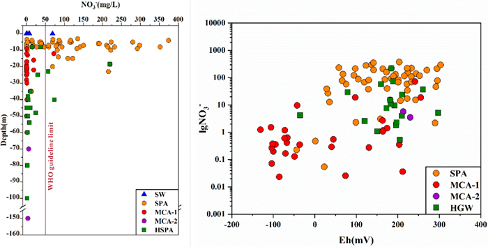
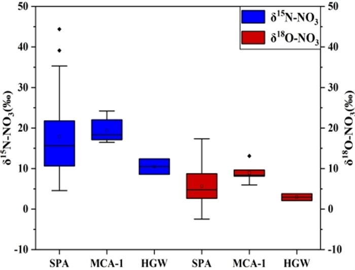
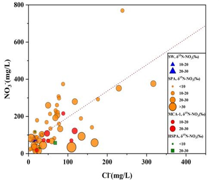
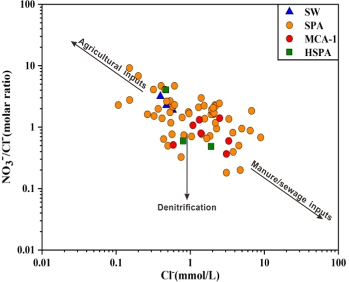
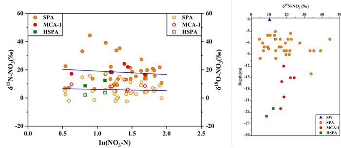
Nitrogen contamination of groundwater in the Jianghan Plain (JHP) in the middle reaches of the Yangtze River is widespread, but the sources and fate of nitrate (NO3-) in the transitional area between plains and hills are poorly understood. This paper characterized the distribution, sources and transformation processes of NO3- in groundwater in the hilly-plain transition area of JHP through hydrogeochemistry and dual isotopes (δ15N and δ18O-NO3-). The hydrogeochemical results showed that the NO3- in the plain and hilly areas is heterogeneous and controlled by topography. From plain to hilly areas in summer, NO3- in groundwater has a general trend of decreasing with the direction of groundwater flow. The groundwater in the plain area is strongly affected by anthropogenic activities, and the NO3- in the multi-level aquifer gradually decreases with increasing depth. Changes in redox conditions caused by river erosion may be responsible for higher NO3- in groundwater along the eroded banks. The isotopic results showed that NO3- in the hilly area mainly comes from soil organic nitrogen, which is a natural source. While, groundwater NO3- in the plain area is strongly affected by livestock manure and domestic sewage, which may be owing to the high density of residents and the impact of anthropogenic activities.


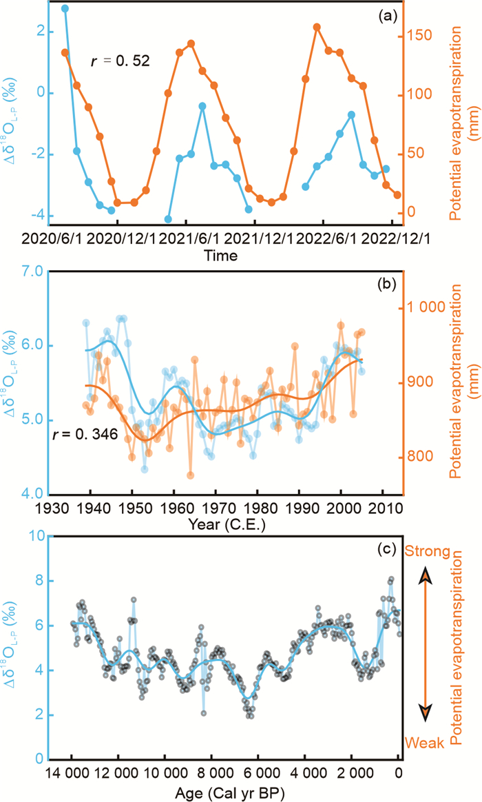
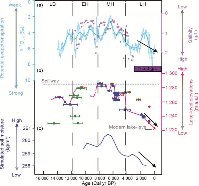
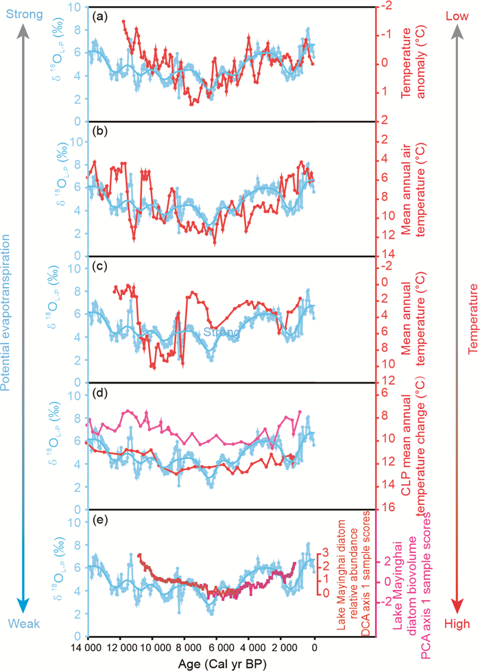
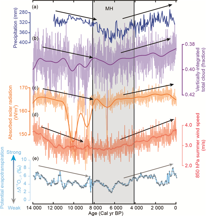
Variations in potential evapotranspiration (PET) are closely linked to regional water equilibria and agricultural productivity. Amid the backdrop of ongoing global warming, PET within the arid and semi-arid regions of northern China (ASARNC), notable for its fragile ecological conditions, exhibits non-monotonic fluctuations. In this study, we selected Dali Lake, a hydrologically closed-lake situated in the ASARNC, as the research object. We calculated ∆δ18OL-P based on δ18OCarb records (indicative of δ18OL) and stalagmite δ18O records (as a proxy for δ18OP) to reconstruct PET changes since the last deglaciation. The findings indicate a gradual decline in PET from ~14 000 cal yr before the present (BP), with PET reaching its minimum around 6 000 cal yr BP. Subsequently, PET exhibited a gradual increase. Moreover, we unveiled an inverse relationship between PET and temperature fluctuations in the ASARNC, suggesting the perpetuation of the evaporation paradox in the region since the last deglaciation. On a millennial timescale, variations in solar radiation (or global dimming) due to changes in cloud or aerosols concentrations, along with shifts in summer wind speed and humidity, rather than surface temperature fluctuations, may primarily drive changes in PET.

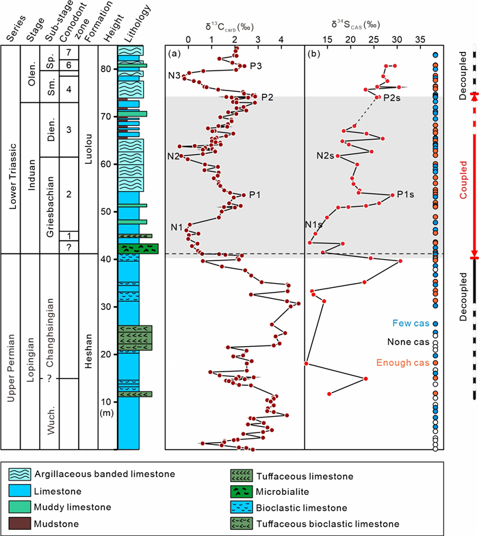
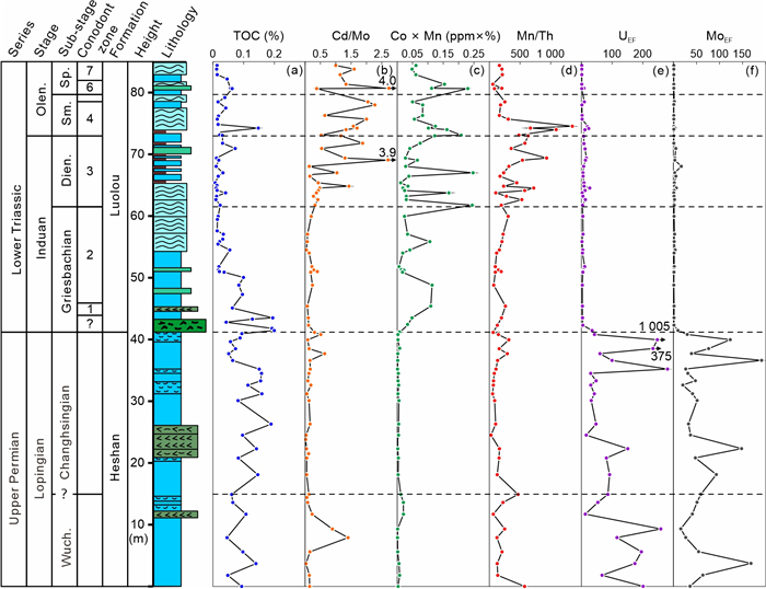
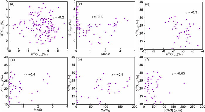
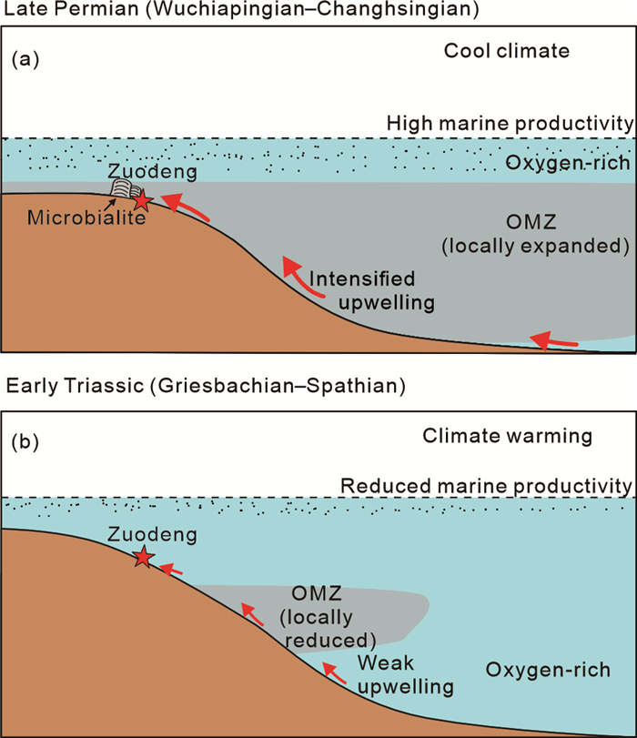
Marine carbon-sulfur cycles experienced long-term frequent perturbations through the Latest Permian to Early Triassic. However, relationships between carbon and sulfur isotopes are still unclear. Here, we report δ13Ccarb and δ34SCAS, and elemental proxies (UEF, MoEF, Mn/Th, Cd/Mo and Co × Mn) from the Wuchiapingian to Spathian successions (Zuodeng Section) in the southern Nanpanjiang Basin, South China. Sudden decreases in both UEF and MoEF values (from ~150 to < 10, and ~60 to < 10, respectively) and a gentle increase in Mn/Th ratios (< 200 to ~1 000) indicate a locally anoxic seawater condition during the Late Permian and an oxic condition during the Early Triassic. Variations of Cd/Mo, Co × Mn and TOC suggest that the Late Permian anoxic condition was related to locally intensive oceanic circulation (e.g., upwelling) and higher marine productivity, which was probably controlled by a relatively cool climate regime, whereas the Early Triassic climate warming may have resulted in intensive oceanic stratification, suppressed marine productivity, and thus narrowed the spatial distribution of the oxygen minimum zone, leaving the study site apart from anoxic water mass in that time. Both δ13Ccarb and δ34SCAS excursions were coupled during the Griesbachian and Dienerian substages probably due to elevated or suppressed marine productivity and co-burial of organic matter and pyrite driven by climatic variations. Decoupled δ13Ccarb-δ34SCAS excursions occurred during the Late Permian and the Smithian global warming, respectively probably because of elevated bacterial sulfate reduction and pyrite burial rate induced by serious global-oceanic anoxia. This study deciphers that dynamic variations of marine carbon-sulfur cycles may have been controlled by extremely environmental changes through the Late Permian to Early Triassic.


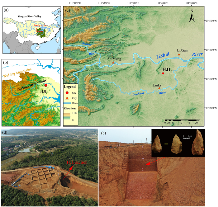
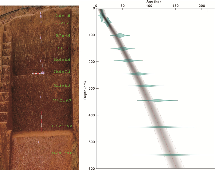
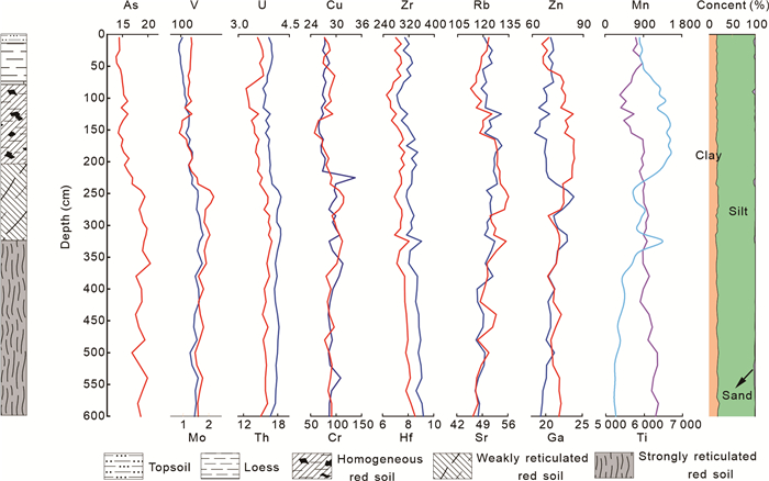
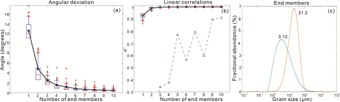
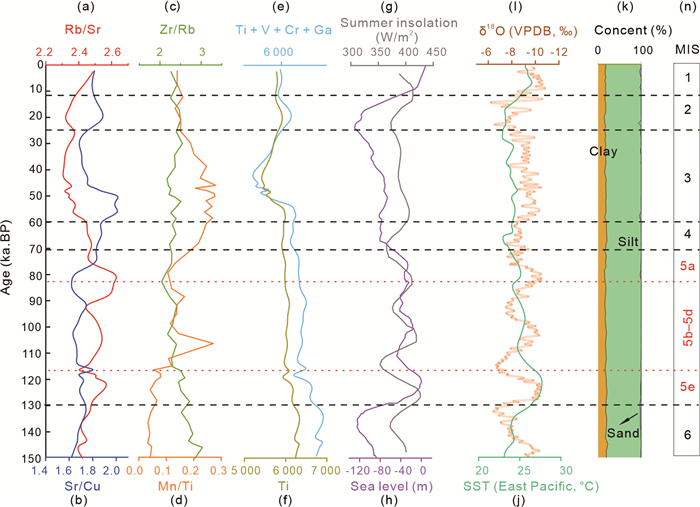
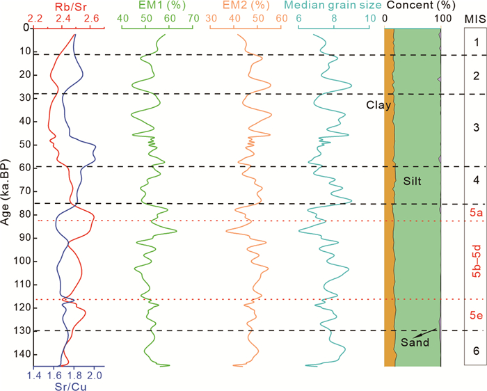
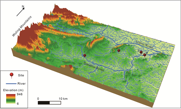
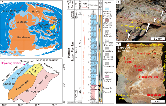
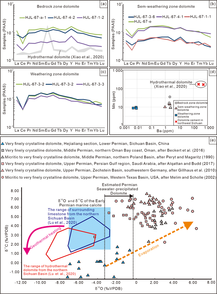
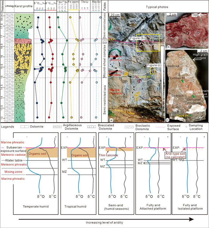
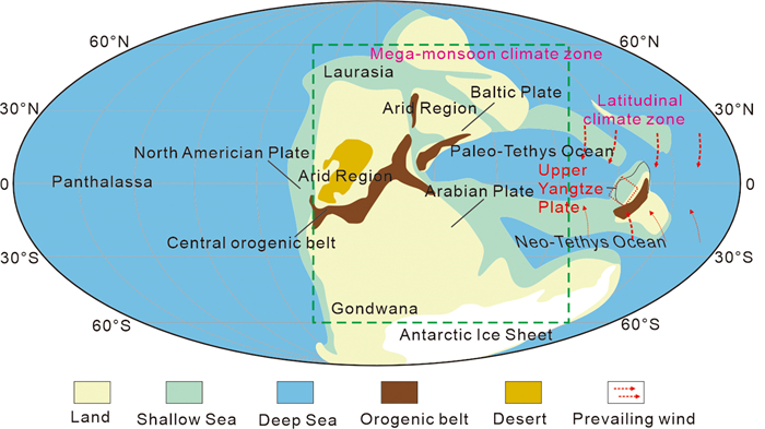
The Paleolithic sites in South China have caused controversy regarding human behaviors in response to the rapidly shifting environment of the Late Pleistocene. However, chronometric and high-resolution proxies are absent from interpreting the paleoenvironmental evolution. Here we present the chronology, grain size parameters, and geochemical elements records from the Hejialing (HJL) site in South China to reveal the crucial aspects of environmental evolution, and human occupation. The geochemical record shows that during MIS 5e–5a, northern Hunan experienced the influence of the summer monsoon and maintained a warm and humid climate. The laterite layer began to develop. During MIS 4, the climate transitioned to a dry and cold state, leading to the attraction of hominins to the HJL area due to the abundant water and lithic raw material resources, resulting in their establishment of a short-term camp. The HJL site was primarily inhabited by hunter-gatherer societies within a forested environment. From MIS 4 to MIS 2, Hunan experienced a prolonged period of dry and cold climatic conditions, with a brief rainfall recovery occurring in late MIS 3. Diminished vegetation and resource availability compelled human populations to broaden their activities and undertake migrations. The HJL site was abandoned amid the arid phase of MIS 2. The HJL area gradually became buried beneath eolian dust deposition (EM1) from distant sources and riverine dust from nearby sources (EM2), and the site was informed. In MIS 1, During MIS 1, the climate shifted to a warm and humid state, marking the emergence of early agricultural practices. As an essential part of South China, the environmental evolution process and diverse survival strategies employed by hominins in Hunan are vital for explaining how the paleoenvironment drove human occupation during the Late Pleistocene.
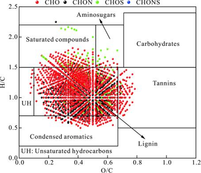
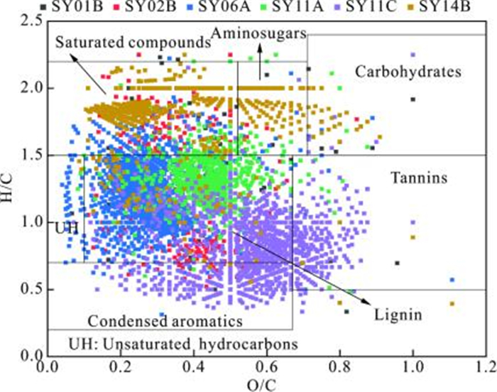
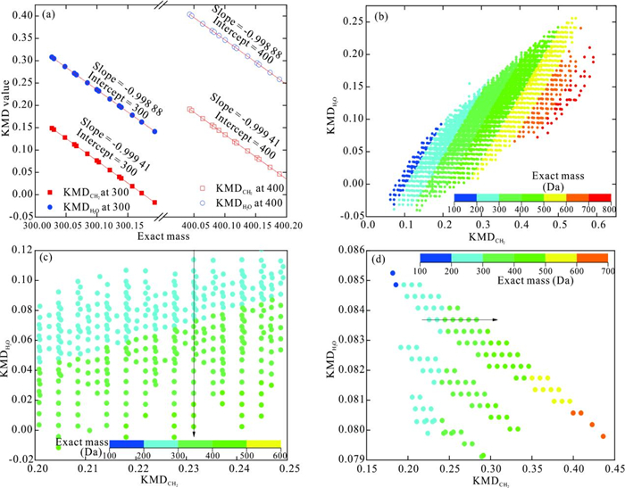
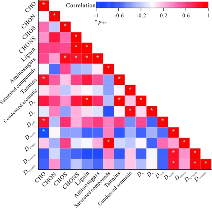
Dissolved organic matter (DOM) is an important reservoir of organic carbon ubiquitously present in various environmental systems. However, information regarding the chemodiversity of groundwater DOM at the molecular level is still limited. Herein, the Fourier transform ion cyclotron resonance mass spectrometry (FT-ICR MS) was used to characterize the molecular composition and chemodiversity of groundwater DOM from the Jianghan Plain, China. Overall, the groundwater DOM was mainly composed of CHO molecules, followed by CHON and CHOS molecules. Results of the Kendrick mass defect (KMD)-based homologous analysis revealed that the majority of CH2-homologue, H2O-homologue, and COO-homologue series generally have 2 to 8, 2 to 6, and 2 to 6 formulae for a given homologous series, respectively. The positive correlation observed among functional diversity indices suggesting that the chemodiversity of groundwater DOM is largely governed by their molecular characteristics could be quantified by the molecular parameter-based functional diversity. The higher functional diversity of unique molecules than common molecules suggests its potential role in tracing the transformation of DOM in various environments. The findings of this study are expected to deepen the understanding of chemical composition and structure, degradation and transformation of groundwater DOM, and its biogeochemical cycle in groundwater and surface water.
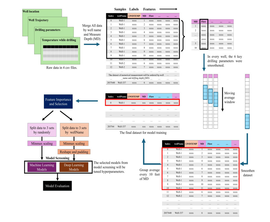
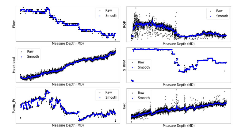
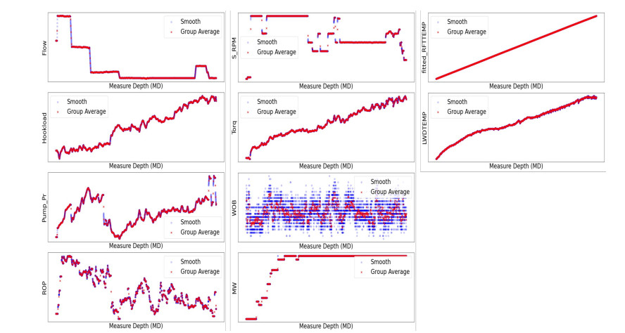
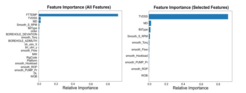
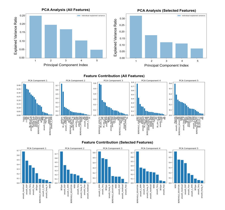
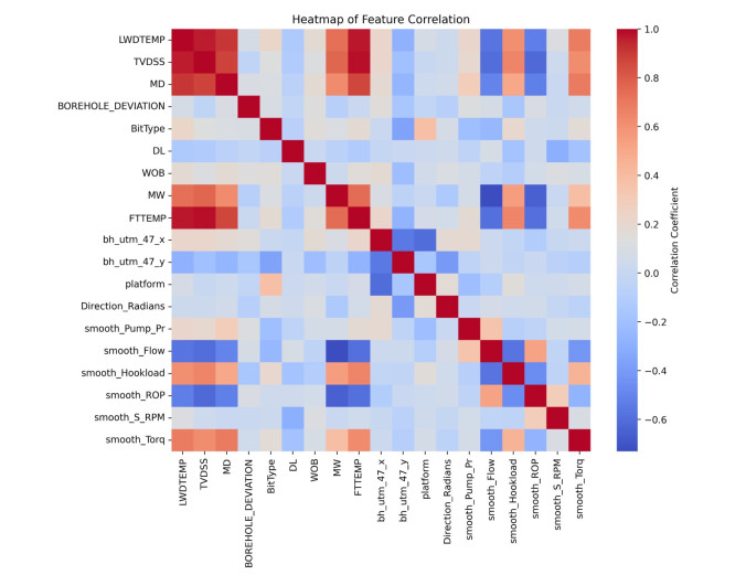
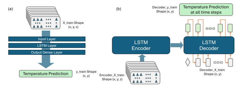
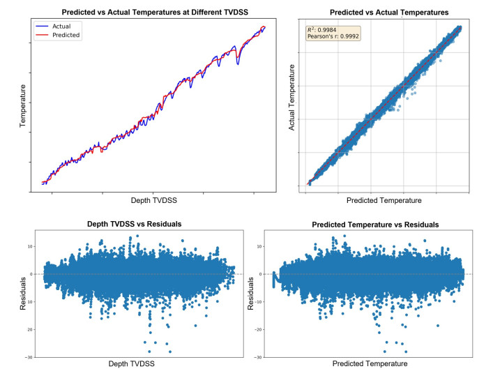
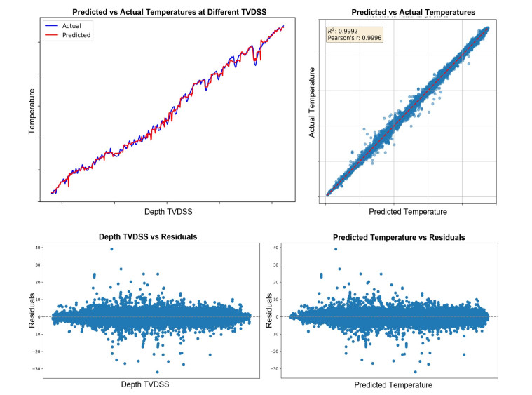
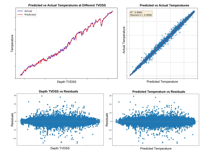
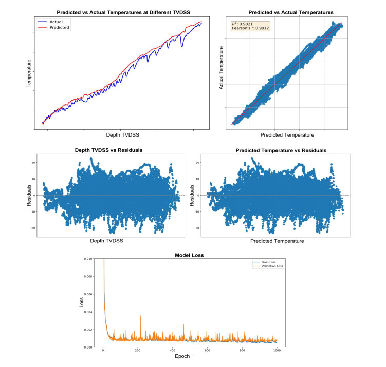
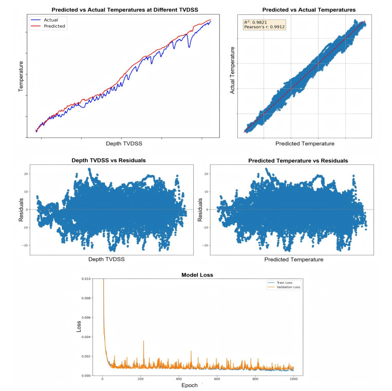
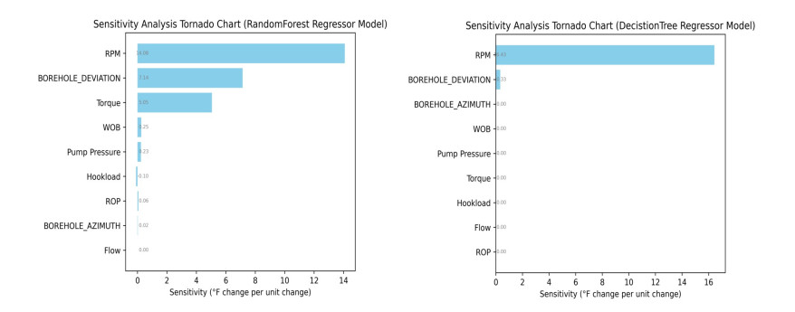
Understanding the dynamic behavior of downhole temperature during drilling operations is crucial for optimizing tool configuration and maximizing the acquisition of logging data, thereby eliminating the need for additional tripping or wireline logging runs. This paper presents a comprehensive study on the application of machine learning and deep learning techniques for predicting downhole temperatures in drilling operations. Following an extensive preprocessing stage that included smoothing and normalizing drilling parameters and related well data, the study compares several machine learning algorithms and long short-term memory (LSTM) architectures. Notable models such as random forest, k-nearest neighbors, decision tree regressors, and LSTM (both sequential and encoder-decoder) were found to be effective for temperature prediction. The LSTM Encoder-Decoder model demonstrated the highest accuracy, with a root mean squared error (RMSE) of 0.892, though it requires higher computational resources. Sensitivity analysis of the model identified revolutions per minute (RPM) and borehole deviation as key factors, providing valuable insights for model refinement and improved thermal management.
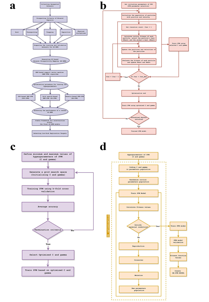
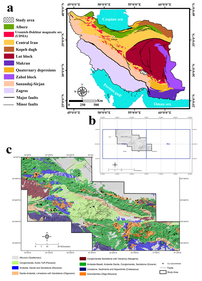
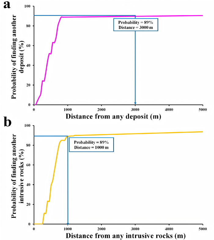
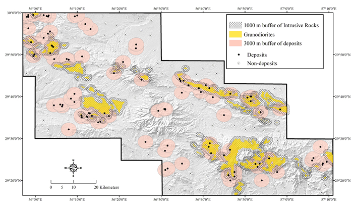
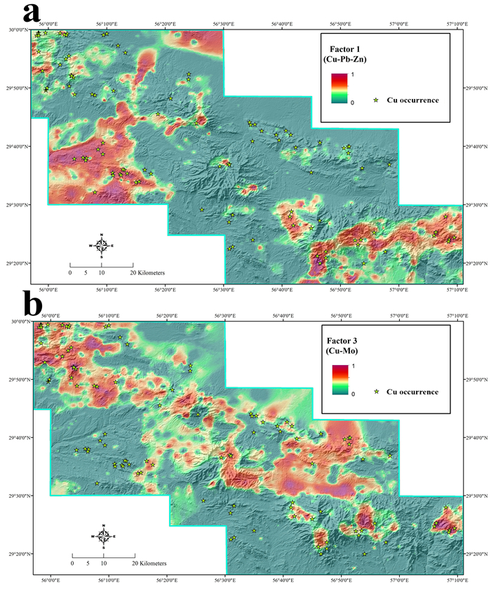
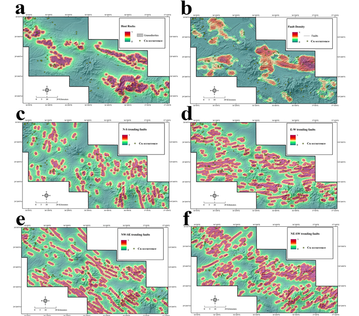
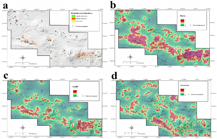
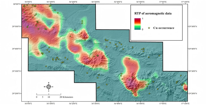
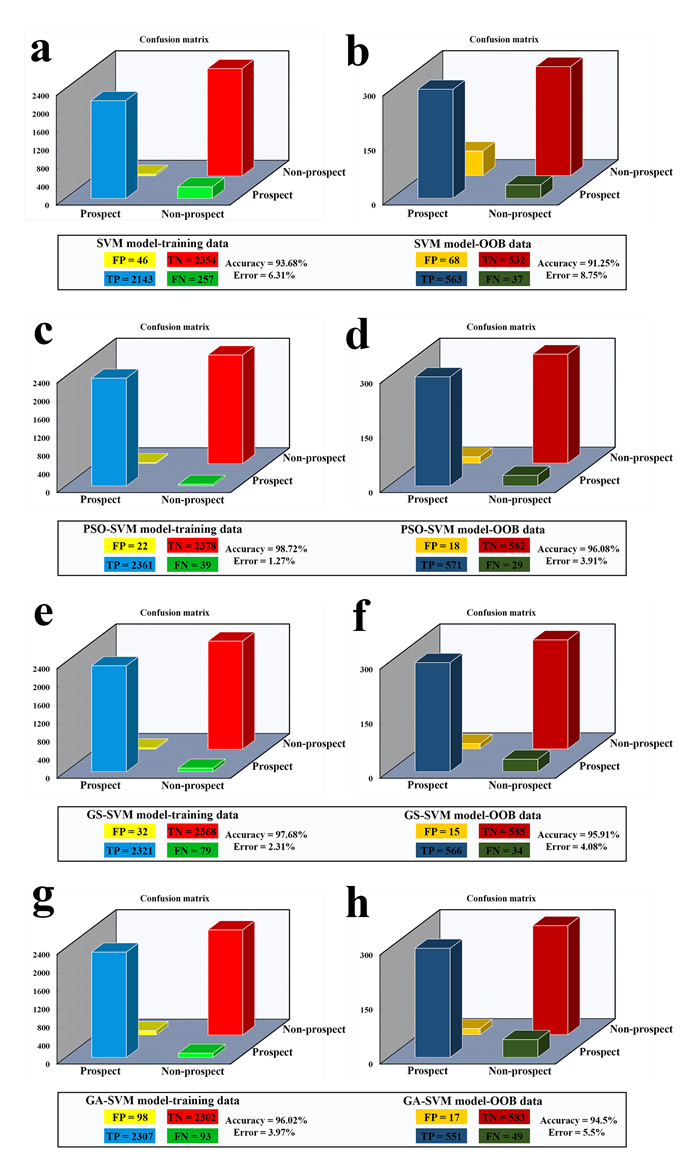
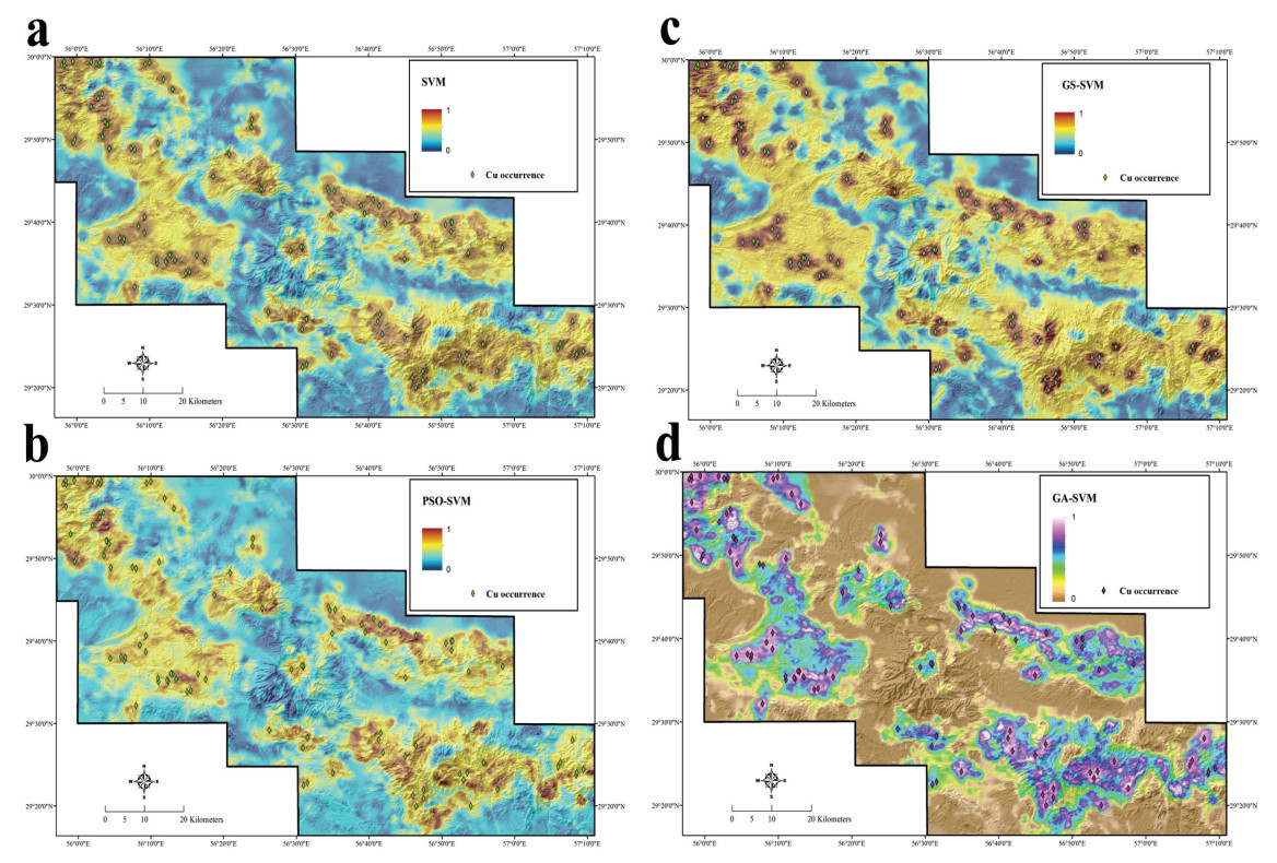
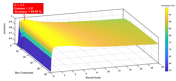
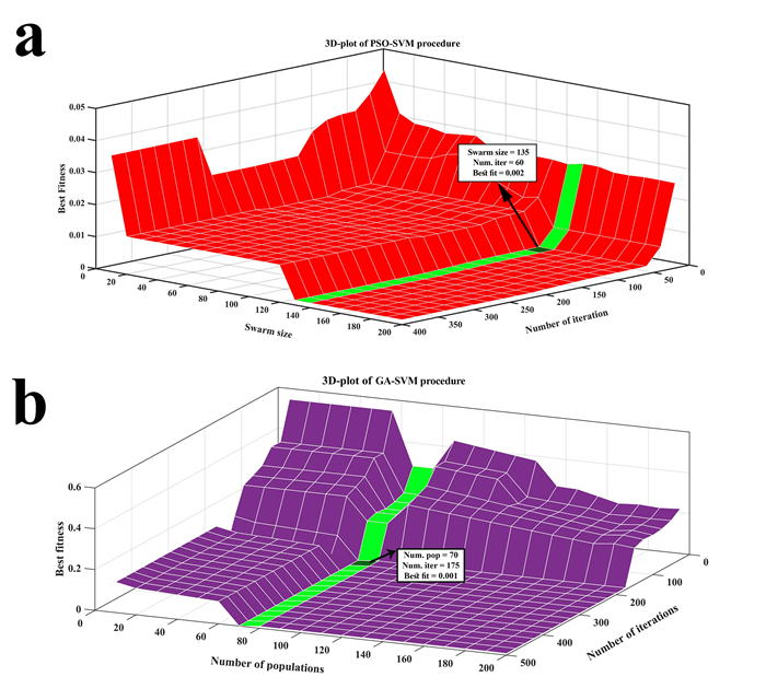
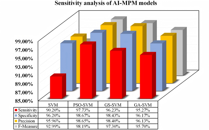
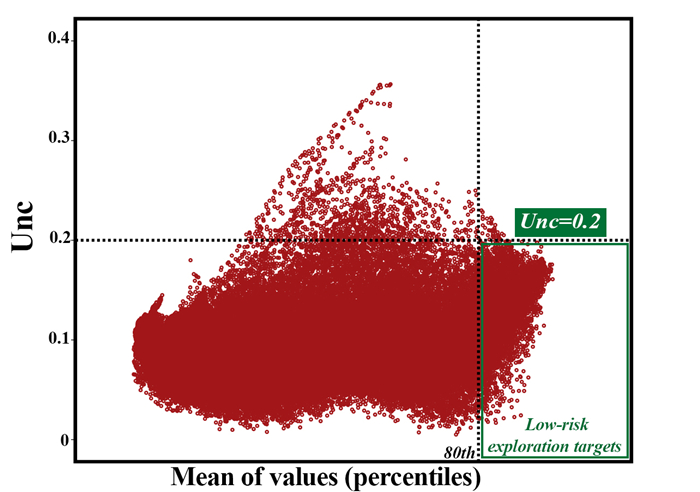
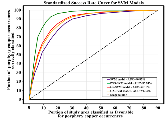
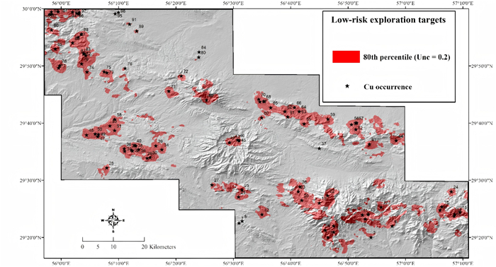
This study brings a revolutionary approach for defining low-risk exploration opportunities in mineral exploration. By harnessing the power of artificial intelligence (AI), it introduces an innovative strategy, known as AI mineral prospectivity mapping (AI-MPM), which aims to discover untapped mineral resources in unexplored territories. It introduces an innovative methodology that examines the uncertainty surrounding SVM-based predictive models. The study focuses on exploring “Cu porphyry mineralization in Kerman belt, Iran,” an area rich in untapped mineral wealth. The researchers utilize cutting-edge optimization algorithms to optimize the performance of SVM algorithm and deduce optimal hyperparameters (e.g., Grid search, PSO and GA). Diverse datasets are synthesized to gain a comprehensive understanding of the study area. The efficiency of auto tuned SVM-based prospectivity models is evaluated using various metrics, including K-fold cross-validation, confusion matrix, and classification accuracy indices values. The research successfully quantifies uncertainty at an individual cell level, enabling accurate identification of low-risk exploration targets. The approach demonstrates remarkable efficiency by covering only 13% of the entire study area. This research paves the way for integrating additional data sources and deploying advanced machine learning techniques to enhance predictive accuracy. Overall, it highlights the potential of SVM-based models in identifying low-risk exploration targets and advancing mineral exploration.
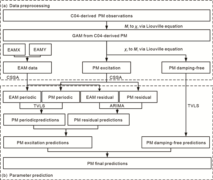
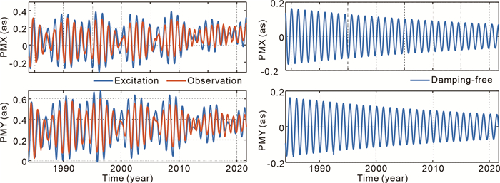
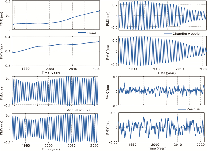
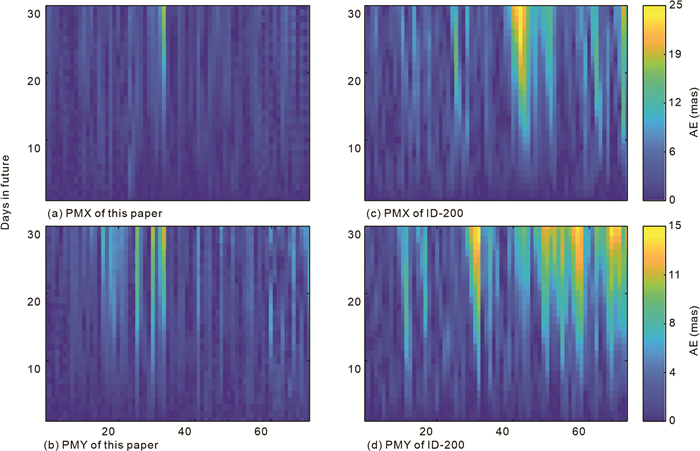
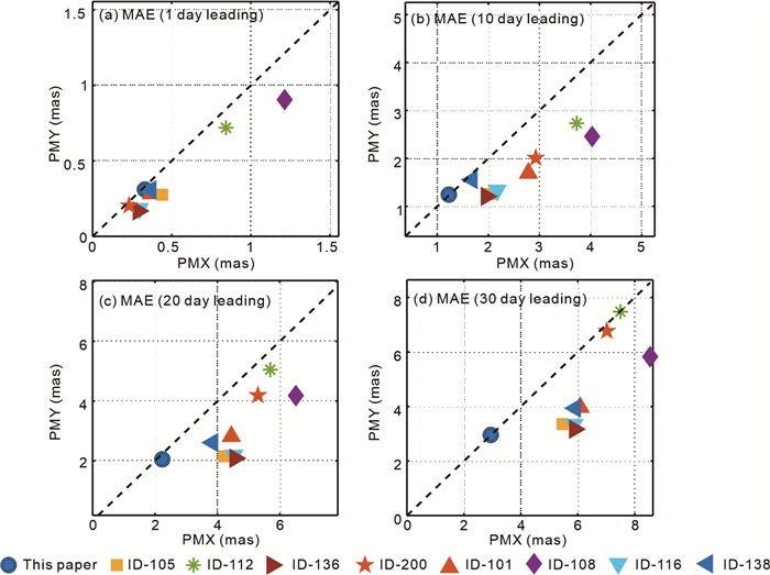
Accurate and rapid short-term (up to 30 days in advance) polar motion (PM) predictions are critical for real-time applications like earthquake monitoring and early warning, global navigation satellite system (GNSS) meteorology, etc. Traditional prediction models, such as the least squares (LS) model, primarily rely on empirical periodic signals with constant amplitude and phase for extrapolation. However, due to complicated internal and external geophysical processes, these signals exhibit irregular variations rather than remaining constant, making it challenging for traditional methods to resolve them autonomously, especially in short-term predictions. To address this issue, we propose a method that combines the LS model with time-varying PM characteristics (TVLS) using the Prony method and the autoregressive integrated moving average (ARIMA) model, along with the effective angular momentum (EAM) data, to enhance the accuracy of short-term PM prediction. Compared with the official predictions disseminated by the International Earth Rotation and Reference Systems Service (IERS), the proposed method improves the prediction accuracy of PMX and PMY by up to 60.84% and 56.70%, respectively. Our method also outperforms the LS + AR + EAM forecast models from the Second Earth Orientation Parameters Prediction Comparison Campaign (2nd EOP PCC), ranking first for forecast horizons beyond 7 days for our predicted PMX and 12 days for PMY. The improvement can be attributed to the core feature of the TVLS model, which constructs a model for the main components of the PM periodic signal based on the Prony method, effectively capturing the non-stationary characteristics by addressing amplitude and phase variations. Therefore, we conclude that the proposed method could significantly enhance short-term PM prediction accuracy and has potential applications in the fields such as real-time satellite orbit determination, precise positioning and navigation.


ISSN 1674-487X
CN 42-1788/P
Editor in Chief: Yanxin Wang
Executive Editors in Chief: Zhong-Qiang Chen, Jiang Shaoyong
Associate Editor:
Shu Jiang,Changdong Li,Rui Ma
Qiliang Sun,Timothy M. Kusky,Dun Wang
Lunche Wang,Long Xiao,Xin-Fu Zhao
Keqing Zong,Renguang Zuo ,Zongjun Yin
2024 Impact Factor 4.7, JCR Q1
JES Citing RankingMore +
- 1Seawater Temperature and Dissolved Oxygen over the Past 500 Million Years
- 2Inventory and Spatial Distribution of Landslides Triggered by the 8th August 2017 MW 6.5 Jiuzhaigou Earthquake, China
- 3Geological Evidence for the Operation of Plate Tectonics throughout the Archean: Records from Archean Paleo-Plate Boundaries
- 4Proto-South China Sea Plate Tectonics Using Subducted Slab Constraints from Tomography
- 5An Optimized Random Forest Model and Its Generalization Ability in Landslide Susceptibility Mapping:Application in Two Areas of Three Gorges Reservoir, China
- 1Dynamic hydromechanical behavior of reservoir slopes: Seepage and deformation under variable water level drawdown
- 2Automatic Stitching Method for Chang'E-2 CCD Images of the Moon
- 3Radial anisotropy in the crust beneath the northeastern Tibetan Plateau from ambient noise tomography
- 4Spatial Variation of Hydraulic Conductivity Categories in a Highly Heterogeneous Aquifer: A Case Study in the North China Plain (NCP)
- 5On the Numerical Modeling of the Deep Mantle Water Cycle in Global-Scale Mantle Dynamics: The Effects of the Water Solubility Limit of Lower Mantle Minerals
- 1Sedimentary Characteristics and Reservoir Prediction of Paleogene in the East Part of Kuqa Foreland Basin
- 2Chemical Composition of Urban Street Sediments and Its Sources
- 3Rainfall Threshold Calculation Method for Debris Flow Pre-Warning in Data-Poor Areas
- 4Hydrocarbon Distribution and Accumulation Model in the South of Lixian Slope, Raoyang Subbasin
- 5Deepwater Canyons Reworked by Bottom Currents: Sedimentary Evolution and Genetic Model
Recommended IssuesMore +
- Satellite remote sensing monitoring and its applications in major engineering projects
- Continental Margins of East and Southeast Asia: Sedimentology, Geomorphology, and Climate change Special Issue in The Journal of Earth Science
- Notice on Collecting “Top 70 Questions Facing Earth Science”
- Call for papers for a special issue of Journal of Earth Science: on Sustainable Technologies for Earth Science and Climate Change
- Tropical Large Benthic Foraminifera: Adaption, Extinction, and Radiation


